Bosanska Krupa
Template:Main other{{#invoke:Infobox|infobox}}Template:Template other{{#invoke:Check for unknown parameters|check|unknown=Template:Main other|preview = Page using [[Template:Template:If empty]] with unknown parameter "_VALUE_"|ignoreblank=y|mapframe_args=y | alt | anthem | anthem_link | area_blank1_acre | area_blank1_dunam | area_blank1_ha | area_blank1_km2 | area_blank1_sq_mi | area_blank1_title | area_blank2_acre | area_blank2_dunam | area_blank2_ha | area_blank2_km2 | area_blank2_sq_mi | area_blank2_title | area_code | area_code_type | area_codes | area_footnotes | area_land_acre | area_land_dunam | area_land_ha | area_land_km2 | area_land_sq_mi | area_metro_acre | area_metro_dunam | area_metro_footnotes | area_metro_ha | area_metro_km2 | area_metro_sq_mi | area_note | area_rank | area_rural_acre | area_rural_dunam | area_rural_footnotes | area_rural_ha | area_rural_km2 | area_rural_sq_mi | area_total_acre | area_total_dunam | area_total_ha | area_total_km2 | area_total_sq_mi | area_urban_acre | area_urban_dunam | area_urban_footnotes | area_urban_ha | area_urban_km2 | area_urban_sq_mi | area_water_acre | area_water_dunam | area_water_ha | area_water_km2 | area_water_percent | area_water_sq_mi | blank_emblem_alt | blank_emblem_link | blank_emblem_size | blank_emblem_type | blank_emblem_sizedefault | blank_emblem_upright | blank_info | blank_info_sec1 | blank_info_sec2 | blank_name | blank_name_sec1 | blank_name_sec2 | blank1_info | blank1_info_sec1 | blank1_info_sec2 | blank1_name | blank1_name_sec1 | blank1_name_sec2 | blank2_info | blank2_info_sec1 | blank2_info_sec2 | blank2_name | blank2_name_sec1 | blank2_name_sec2 | blank3_info | blank3_info_sec1 | blank3_info_sec2 | blank3_name | blank3_name_sec1 | blank3_name_sec2 | blank4_info | blank4_info_sec1 | blank4_info_sec2 | blank4_name | blank4_name_sec1 | blank4_name_sec2 | blank5_info | blank5_info_sec1 | blank5_info_sec2 | blank5_name | blank5_name_sec1 | blank5_name_sec2 | blank6_info | blank6_info_sec1 | blank6_info_sec2 | blank6_name | blank6_name_sec1 | blank6_name_sec2 | blank7_info | blank7_info_sec1 | blank7_info_sec2 | blank7_name | blank7_name_sec1 | blank7_name_sec2 | caption | code1_info | code1_name | code2_info | code2_name | coor_pinpoint | coor_type | coordinates | coordinates_footnotes | demographics_type1 | demographics_type2 | demographics1_footnotes | demographics1_info1 | demographics1_info10 | demographics1_info2 | demographics1_info3 | demographics1_info4 | demographics1_info5 | demographics1_info6 | demographics1_info7 | demographics1_info8 | demographics1_info9 | demographics1_title1 | demographics1_title10 | demographics1_title2 | demographics1_title3 | demographics1_title4 | demographics1_title5 | demographics1_title6 | demographics1_title7 | demographics1_title8 | demographics1_title9 | demographics2_footnotes | demographics2_info1 | demographics2_info10 | demographics2_info2 | demographics2_info3 | demographics2_info4 | demographics2_info5 | demographics2_info6 | demographics2_info7 | demographics2_info8 | demographics2_info9 | demographics2_title1 | demographics2_title10 | demographics2_title2 | demographics2_title3 | demographics2_title4 | demographics2_title5 | demographics2_title6 | demographics2_title7 | demographics2_title8 | demographics2_title9 | dimensions_footnotes | dunam_link | elevation_footnotes | elevation_ft | elevation_link | elevation_m | elevation_max_footnotes | elevation_max_ft | elevation_max_m | elevation_max_point | elevation_max_rank | elevation_min_footnotes | elevation_min_ft | elevation_min_m | elevation_min_point | elevation_min_rank | elevation_point | embed | established_date | established_date1 | established_date2 | established_date3 | established_date4 | established_date5 | established_date6 | established_date7 | established_title | established_title1 | established_title2 | established_title3 | established_title4 | established_title5 | established_title6 | established_title7 | etymology | extinct_date | extinct_title | flag_alt | flag_border | flag_link | flag_size | footnotes | founder | geocode | governing_body | government_footnotes | government_type | government_blank1_title | government_blank1 | government_blank2_title | government_blank2 | government_blank2_title | government_blank3 | government_blank3_title | government_blank3 | government_blank4_title | government_blank4 | government_blank5_title | government_blank5 | government_blank6_title | government_blank6 | grid_name | grid_position | image_alt | image_blank_emblem | image_caption | image_flag | image_map | image_map1 | image_seal | image_shield | image_size | image_skyline | imagesize | image_sizedefault | image_upright | iso_code | leader_name | leader_name1 | leader_name2 | leader_name3 | leader_name4 | leader_name5 | leader_party | leader_title | leader_title1 | leader_title2 | leader_title3 | leader_title4 | leader_title5 | length_km | length_mi | map_alt | map_alt1 | map_caption | map_caption1 | mapsize | mapsize1 | module | motto | motto_link | mottoes | name | named_for | native_name | native_name_lang | nickname | nickname_link | nicknames | official_name | other_name | p1 | p10 | p11 | p12 | p13 | p14 | p15 | p16 | p17 | p18 | p19 | p2 | p20 | p21 | p22 | p23 | p24 | p25 | p26 | p27 | p28 | p29 | p3 | p30 | p31 | p32 | p33 | p34 | p35 | p36 | p37 | p38 | p39 | p4 | p40 | p41 | p42 | p43 | p44 | p45 | p46 | p47 | p48 | p49 | p5 | p50 | p6 | p7 | p8 | p9 | parts | parts_style | parts_type | pop_est_as_of | pop_est_footnotes | population | population_as_of | population_blank1 | population_blank1_footnotes | population_blank1_title | population_blank2 | population_blank2_footnotes | population_blank2_title | population_demonym | population_demonyms | population_density_blank1_km2 | population_density_blank1_sq_mi | population_density_blank2_km2 | population_density_blank2_sq_mi | population_density_km2 | population_density_metro_km2 | population_density_metro_sq_mi | population_density_rank | population_density_rural_km2 | population_density_rural_sq_mi | population_density_sq_mi | population_density_urban_km2 | population_density_urban_sq_mi | population_est | population_footnotes | population_metro | population_metro_footnotes | population_note | population_rank | population_rural | population_rural_footnotes | population_total | population_urban | population_urban_footnotes | postal_code | postal_code_type | postal2_code | postal2_code_type | pushpin_image | pushpin_label | pushpin_label_position | pushpin_map | pushpin_map_alt | pushpin_map_caption | pushpin_map_caption_notsmall | pushpin_map_narrow | pushpin_mapsize | pushpin_outside | pushpin_overlay | pushpin_relief | registration_plate | registration_plate_type | seal_alt | seal_link | seal_size | seal_type | seat | seat_type | seat1 | seat1_type | seat2 | seat2_type | settlement_type | shield_alt | shield_link | shield_size | short_description | subdivision_name | subdivision_name1 | subdivision_name2 | subdivision_name3 | subdivision_name4 | subdivision_name5 | subdivision_name6 | subdivision_type | subdivision_type1 | subdivision_type2 | subdivision_type3 | subdivision_type4 | subdivision_type5 | subdivision_type6 | template_name | timezone | timezone_DST | timezone_link | timezone1 | timezone1_DST | timezone1_location | timezone2 | timezone2_DST | timezone2_location | timezone3 | timezone3_DST | timezone3_location | timezone4 | timezone4_DST | timezone4_location | timezone5 | timezone5_DST | timezone5_location | total_type | translit_lang1 | translit_lang1_info | translit_lang1_info1 | translit_lang1_info2 | translit_lang1_info3 | translit_lang1_info4 | translit_lang1_info5 | translit_lang1_info6 | translit_lang1_type | translit_lang1_type1 | translit_lang1_type2 | translit_lang1_type3 | translit_lang1_type4 | translit_lang1_type5 | translit_lang1_type6 | translit_lang2 | translit_lang2_info | translit_lang2_info1 | translit_lang2_info2 | translit_lang2_info3 | translit_lang2_info4 | translit_lang2_info5 | translit_lang2_info6 | translit_lang2_type | translit_lang2_type1 | translit_lang2_type2 | translit_lang2_type3 | translit_lang2_type4 | translit_lang2_type5 | translit_lang2_type6 | type | unit_pref | utc_offset | utc_offset_DST | utc_offset1 | utc_offset1_DST | utc_offset2 | utc_offset2_DST | utc_offset3 | utc_offset3_DST | utc_offset4 | utc_offset4_DST | utc_offset5 | utc_offset5_DST | website | width_km | width_mi }}{{#invoke:Check for clobbered parameters|check | template = [[Template:Template:If empty]] | cat = Template:Main other | population; population_total | image_size; imagesize | image_alt; alt | image_caption; caption | settlement_type; type | utc_offset1; utc_offset | timezone1; timezone }}{{#if:
|
}}Template:Main other{{#ifexpr:{{#invoke:ParameterCount|main|mapframe|image_map|image_map1|pushpin_map}} >2 |Template:Main other}}
Bosanska Krupa (Template:Lang-sr-cyrl) is a city located in the Una-Sana Canton of the Federation of Bosnia and Herzegovina, an entity of Bosnia and Herzegovina. As of 2013, it has a population of 29,659 inhabitants.
It is situated on the banks of river Una in northwestern Bosnia and Herzegovina, Template:Convert northeast from Bihać (350 km away from Sarajevo).
History
When the German and Italian Zones of Influence were revised on 24 June 1942, Bosanska Krupa fell in Template:Ill, administered civilly by Croatia and militarily by Croatia and Germany.Template:Sfn
Geography
Bosanska Krupa is on the border within the Federation of Bosnia and Herzegovina adjacent to the municipalities of Bužim, Cazin, Bihać, Bosanski Petrovac, Sanski Most, and Krupa na Uni. The last mentioned municipality is part of the Republika Srpska entity and was part of the Bosanska Krupa municipality before the Bosnian War, but after the Dayton Agreement it became a separate municipality.
Settlements
- Arapuša
- Banjani
- Baštra
- Benakovac
- Donja Suvaja
- Drenova Glavica
- Glavica
- Gorinja
- Gornja Suvaja
- Gornji Bušević
- Gornji Petrovići
- Gudavac
- Hašani
- Ivanjska
- Jasenica
- Jezerski
- Ljusina
- Mahmić Selo
- Mali Badić
- Mali Radić
- Ostrožnica
- Bosanska Otoka
- Perna
- Pištaline
- Potkalinje
- Pučenik
- Srednji Bušević
- Srednji Dubovik
- Velika Jasenica
- Veliki Badić
- Veliki Dubovik
- Veliki Radić
- Vojevac
- Voloder
- Vranjska
- Zalin
Demographics
Population
| Population of settlements – Bosanska Krupa municipality | ||||||
|---|---|---|---|---|---|---|
| Settlement | 1961. | 1971. | 1981. | 1991. | 2013. | |
| Total | 46,020 | 50,856 | 55,229 | 58,320 | 29,659 | |
| 1 | Arapuša | 536 | 273 | |||
| 2 | Banjani | 501 | 332 | |||
| 3 | Baštra | 186 | 204 | |||
| 4 | Bosanska Krupa | 8,974 | 12,055 | 14,416 | 10,196 | |
| 5 | Drenova Glavica | 376 | 253 | |||
| 6 | Ivanjska | 633 | 309 | |||
| 7 | Jezerski | 3,322 | 2,756 | |||
| 8 | Ljusina | 1,315 | 1,237 | |||
| 9 | Mahmić Selo | 1,714 | 1,369 | |||
| 10 | Ostrožnica | 1,201 | 794 | |||
| 11 | Otoka | 4,063 | 3,221 | |||
| 12 | Pištaline | 1,541 | 1,316 | |||
| 13 | Veliki Badić | 1,237 | 794 | |||
| 14 | Voloder | 1,060 | 1,114 | |||
Ethnic composition
| Ethnic composition – Bosanska Krupa town | |||||||
|---|---|---|---|---|---|---|---|
| 2013. | 1991. | 1981. | 1971. | ||||
| Total | 10,196 (100,0%) | 14,416 (100,0%) | 12,055 (100,0%) | 8,974 (100,0%) | |||
| Bosniaks | 9,859 (96,70%) | 9,519 (66,03%) | 6,858 (56,89%) | 6,070 (67,64%) | |||
| Roma | 116 (1,138%) | ||||||
| Unaffiliated | 56 (0,549%) | ||||||
| Serbs | 54 (0,530%) | 4,044 (28,05%) | 3,142 (26,06%) | 2,433 (27,11%) | |||
| Croats | 50 (0,490%) | 102 (0,708%) | 109 (0,904%) | 202 (2,251%) | |||
| Albanians | 21 (0,206%) | ||||||
| Others | 19 (0,186%) | 200 (1,387%) | 182 (1,510%) | 86 (0,958%) | |||
| Unknown | 16 (0,157%) | ||||||
| Yugoslavs | 2 (0,020%) | 551 (3,822%) | 1,764 (14,63%) | 183 (2,039%) | |||
| Macedonians | 1 (0,010%) | ||||||
| Slovenes | 1 (0,010%) | ||||||
| Turks | 1 (0,010%) | ||||||
| Ethnic composition – Bosanska Krupa municipality | ||||||||
|---|---|---|---|---|---|---|---|---|
| 2013. | 1991. | 1981. | 1971. | 1961. | ||||
| Total | 29,659 (100,0%) | 58,320 (100,0%) | 55,229 (100,0%) | 50,856 (100,0%) | 46,020 (100,0%) | |||
| Bosniaks | 23,886 (93,50%) | 43,104 (73,91%) | 37,381 (67,68%) | 31,842 (62,61%) | 23,721 (51,54%) | |||
| Serbs | 1,265 (4,952%) | 13,841 (23,73%) | 15,029 (27,21%) | 18,230 (35,85%) | 20,453 (44,44%) | |||
| Roma | 118 (0,462%) | 3 (0,005%) | ||||||
| Unaffiliated | 106 (0,415%) | |||||||
| Croats | 66 (0,258%) | 139 (0,238%) | 173 (0,313%) | 286 (0,562%) | 453 (0,980%) | |||
| Unknown | 41 (0,161%) | |||||||
| Others | 30 (0,117%) | 528 (0,905%) | 251 (0,454%) | 216 (0,425%) | 122 (0,270%) | |||
| Albanians | 23 (0,090%) | 13 (0,024%) | 13 (0,026%) | |||||
| Yugoslavs | 5 (0,020%) | 708 (1,214%) | 2,314 (4,190%) | 239 (0,470%) | 1,271 (2,760%) | |||
| Slovenes | 3 (0,012%) | 9 (0,016%) | 11 (0,022%) | |||||
| Macedonians | 1 (0,004%) | 7 (0,013%) | ||||||
| Turks | 1 (0,004%) | |||||||
| Montenegrins | 49 (0,089%) | 19 (0,037%) | ||||||
Notable people
- Džemaludin Čaušević, Grand Mufti for Bosnia and Herzegovina (1914 to 1930)
- Branko Ćopić, writer (Hašani)
- Kosta Hakman, painter
- Elvis Mešić, football player
Gallery
-
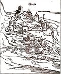 Krupa in the Middle Ages
 -
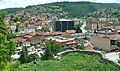 Bosanska Krupa
 -
 Bosanska Krupa
 -
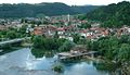 Bosanska Krupa
 -
 Bosanska Krupa


See also
References
Bibliography
External links
Template:Una Sana Canton {{#invoke:Navbox|navbox}} Template:Authority control