Chatham Township, New Jersey
Template:Short description Template:About Template:Use American English Template:Use mdy dates Template:Main other{{#invoke:Infobox|infobox}}Template:Template other{{#invoke:Check for unknown parameters|check|unknown=Template:Main other|preview = Page using [[Template:Template:If empty]] with unknown parameter "_VALUE_"|ignoreblank=y|mapframe_args=y | alt | anthem | anthem_link | area_blank1_acre | area_blank1_dunam | area_blank1_ha | area_blank1_km2 | area_blank1_sq_mi | area_blank1_title | area_blank2_acre | area_blank2_dunam | area_blank2_ha | area_blank2_km2 | area_blank2_sq_mi | area_blank2_title | area_code | area_code_type | area_codes | area_footnotes | area_land_acre | area_land_dunam | area_land_ha | area_land_km2 | area_land_sq_mi | area_metro_acre | area_metro_dunam | area_metro_footnotes | area_metro_ha | area_metro_km2 | area_metro_sq_mi | area_note | area_rank | area_rural_acre | area_rural_dunam | area_rural_footnotes | area_rural_ha | area_rural_km2 | area_rural_sq_mi | area_total_acre | area_total_dunam | area_total_ha | area_total_km2 | area_total_sq_mi | area_urban_acre | area_urban_dunam | area_urban_footnotes | area_urban_ha | area_urban_km2 | area_urban_sq_mi | area_water_acre | area_water_dunam | area_water_ha | area_water_km2 | area_water_percent | area_water_sq_mi | blank_emblem_alt | blank_emblem_link | blank_emblem_size | blank_emblem_type | blank_emblem_sizedefault | blank_emblem_upright | blank_info | blank_info_sec1 | blank_info_sec2 | blank_name | blank_name_sec1 | blank_name_sec2 | blank1_info | blank1_info_sec1 | blank1_info_sec2 | blank1_name | blank1_name_sec1 | blank1_name_sec2 | blank2_info | blank2_info_sec1 | blank2_info_sec2 | blank2_name | blank2_name_sec1 | blank2_name_sec2 | blank3_info | blank3_info_sec1 | blank3_info_sec2 | blank3_name | blank3_name_sec1 | blank3_name_sec2 | blank4_info | blank4_info_sec1 | blank4_info_sec2 | blank4_name | blank4_name_sec1 | blank4_name_sec2 | blank5_info | blank5_info_sec1 | blank5_info_sec2 | blank5_name | blank5_name_sec1 | blank5_name_sec2 | blank6_info | blank6_info_sec1 | blank6_info_sec2 | blank6_name | blank6_name_sec1 | blank6_name_sec2 | blank7_info | blank7_info_sec1 | blank7_info_sec2 | blank7_name | blank7_name_sec1 | blank7_name_sec2 | caption | code1_info | code1_name | code2_info | code2_name | coor_pinpoint | coor_type | coordinates | coordinates_footnotes | demographics_type1 | demographics_type2 | demographics1_footnotes | demographics1_info1 | demographics1_info10 | demographics1_info2 | demographics1_info3 | demographics1_info4 | demographics1_info5 | demographics1_info6 | demographics1_info7 | demographics1_info8 | demographics1_info9 | demographics1_title1 | demographics1_title10 | demographics1_title2 | demographics1_title3 | demographics1_title4 | demographics1_title5 | demographics1_title6 | demographics1_title7 | demographics1_title8 | demographics1_title9 | demographics2_footnotes | demographics2_info1 | demographics2_info10 | demographics2_info2 | demographics2_info3 | demographics2_info4 | demographics2_info5 | demographics2_info6 | demographics2_info7 | demographics2_info8 | demographics2_info9 | demographics2_title1 | demographics2_title10 | demographics2_title2 | demographics2_title3 | demographics2_title4 | demographics2_title5 | demographics2_title6 | demographics2_title7 | demographics2_title8 | demographics2_title9 | dimensions_footnotes | dunam_link | elevation_footnotes | elevation_ft | elevation_link | elevation_m | elevation_max_footnotes | elevation_max_ft | elevation_max_m | elevation_max_point | elevation_max_rank | elevation_min_footnotes | elevation_min_ft | elevation_min_m | elevation_min_point | elevation_min_rank | elevation_point | embed | established_date | established_date1 | established_date2 | established_date3 | established_date4 | established_date5 | established_date6 | established_date7 | established_title | established_title1 | established_title2 | established_title3 | established_title4 | established_title5 | established_title6 | established_title7 | etymology | extinct_date | extinct_title | flag_alt | flag_border | flag_link | flag_size | footnotes | founder | geocode | governing_body | government_footnotes | government_type | government_blank1_title | government_blank1 | government_blank2_title | government_blank2 | government_blank2_title | government_blank3 | government_blank3_title | government_blank3 | government_blank4_title | government_blank4 | government_blank5_title | government_blank5 | government_blank6_title | government_blank6 | grid_name | grid_position | image_alt | image_blank_emblem | image_caption | image_flag | image_map | image_map1 | image_seal | image_shield | image_size | image_skyline | imagesize | image_sizedefault | image_upright | iso_code | leader_name | leader_name1 | leader_name2 | leader_name3 | leader_name4 | leader_name5 | leader_party | leader_title | leader_title1 | leader_title2 | leader_title3 | leader_title4 | leader_title5 | length_km | length_mi | map_alt | map_alt1 | map_caption | map_caption1 | mapsize | mapsize1 | module | motto | motto_link | mottoes | name | named_for | native_name | native_name_lang | nickname | nickname_link | nicknames | official_name | other_name | p1 | p10 | p11 | p12 | p13 | p14 | p15 | p16 | p17 | p18 | p19 | p2 | p20 | p21 | p22 | p23 | p24 | p25 | p26 | p27 | p28 | p29 | p3 | p30 | p31 | p32 | p33 | p34 | p35 | p36 | p37 | p38 | p39 | p4 | p40 | p41 | p42 | p43 | p44 | p45 | p46 | p47 | p48 | p49 | p5 | p50 | p6 | p7 | p8 | p9 | parts | parts_style | parts_type | pop_est_as_of | pop_est_footnotes | population | population_as_of | population_blank1 | population_blank1_footnotes | population_blank1_title | population_blank2 | population_blank2_footnotes | population_blank2_title | population_demonym | population_demonyms | population_density_blank1_km2 | population_density_blank1_sq_mi | population_density_blank2_km2 | population_density_blank2_sq_mi | population_density_km2 | population_density_metro_km2 | population_density_metro_sq_mi | population_density_rank | population_density_rural_km2 | population_density_rural_sq_mi | population_density_sq_mi | population_density_urban_km2 | population_density_urban_sq_mi | population_est | population_footnotes | population_metro | population_metro_footnotes | population_note | population_rank | population_rural | population_rural_footnotes | population_total | population_urban | population_urban_footnotes | postal_code | postal_code_type | postal2_code | postal2_code_type | pushpin_image | pushpin_label | pushpin_label_position | pushpin_map | pushpin_map_alt | pushpin_map_caption | pushpin_map_caption_notsmall | pushpin_map_narrow | pushpin_mapsize | pushpin_outside | pushpin_overlay | pushpin_relief | registration_plate | registration_plate_type | seal_alt | seal_link | seal_size | seal_type | seat | seat_type | seat1 | seat1_type | seat2 | seat2_type | settlement_type | shield_alt | shield_link | shield_size | short_description | subdivision_name | subdivision_name1 | subdivision_name2 | subdivision_name3 | subdivision_name4 | subdivision_name5 | subdivision_name6 | subdivision_type | subdivision_type1 | subdivision_type2 | subdivision_type3 | subdivision_type4 | subdivision_type5 | subdivision_type6 | template_name | timezone | timezone_DST | timezone_link | timezone1 | timezone1_DST | timezone1_location | timezone2 | timezone2_DST | timezone2_location | timezone3 | timezone3_DST | timezone3_location | timezone4 | timezone4_DST | timezone4_location | timezone5 | timezone5_DST | timezone5_location | total_type | translit_lang1 | translit_lang1_info | translit_lang1_info1 | translit_lang1_info2 | translit_lang1_info3 | translit_lang1_info4 | translit_lang1_info5 | translit_lang1_info6 | translit_lang1_type | translit_lang1_type1 | translit_lang1_type2 | translit_lang1_type3 | translit_lang1_type4 | translit_lang1_type5 | translit_lang1_type6 | translit_lang2 | translit_lang2_info | translit_lang2_info1 | translit_lang2_info2 | translit_lang2_info3 | translit_lang2_info4 | translit_lang2_info5 | translit_lang2_info6 | translit_lang2_type | translit_lang2_type1 | translit_lang2_type2 | translit_lang2_type3 | translit_lang2_type4 | translit_lang2_type5 | translit_lang2_type6 | type | unit_pref | utc_offset | utc_offset_DST | utc_offset1 | utc_offset1_DST | utc_offset2 | utc_offset2_DST | utc_offset3 | utc_offset3_DST | utc_offset4 | utc_offset4_DST | utc_offset5 | utc_offset5_DST | website | width_km | width_mi }}{{#invoke:Check for clobbered parameters|check | template = [[Template:Template:If empty]] | cat = Template:Main other | population; population_total | image_size; imagesize | image_alt; alt | image_caption; caption | settlement_type; type | utc_offset1; utc_offset | timezone1; timezone }}{{#if:
|
}}Template:Main other{{#ifexpr:{{#invoke:ParameterCount|main|mapframe|image_map|image_map1|pushpin_map}} >2 |Template:Main other}} Chatham Township is a suburban township located in Morris County, in the U.S. state of New Jersey. As of the 2020 United States census, the township's population was 10,983,<ref name=Census2020/><ref name=LWD2020/> its highest decennial count ever and an increase of 531 (+5.1%) from the 10,452 recorded at the 2010 census,<ref name=Census2010/><ref name=LWD2010/> which in turn reflected an increase of 366 (+3.6%) from the 10,086 counted in the 2000 census.<ref>Table 7. Population for the Counties and Municipalities in New Jersey: 1990, 2000 and 2010, New Jersey Department of Labor and Workforce Development, February 2011. Accessed May 1, 2023.</ref> The long-established hamlet of Green Village (also within Harding Township) is located in Chatham Township.
The presence of the Chatham station along the Morris and Essex Lines in neighboring Chatham Borough proved a vital role in population increases in Chatham Township, which began to be developed for residential use due to its easy commute to nearby Manhattan.<ref>History, Chatham Township. Accessed April 24, 2021. "The most important transportation development was the coming of the Morris and Essex Railroad in 1837. This led to sharp increases in the population, which resulted in incorporating Chatham, Madison and Florham Park as separate boroughs."</ref>
New Jersey Monthly magazine ranked Chatham Township first in the state in its 2008 rankings of the "Best Places to Live" in New Jersey.<ref>"Best Places To Live - The Complete Top Towns List" Template:Webarchive, New Jersey Monthly, February 21, 2008. Accessed May 11, 2008.</ref>
The township has been one of the state's highest-income communities. Based on data from the 2013–2017 American Community Survey, township residents had a median household income of $176,364, ranked 3rd in the state among municipalities with more than 10,000 residents, more than double the statewide median of $76,475.<ref>Raychaudhuri, Disha. "The wealthiest towns in N.J., ranked", NJ Advance Media for NJ.com, June 7, 2019. Accessed November 4, 2019. "The median household income in N.J. is $76,475, recent Census data shows.... A note about the data: The data comes from 2013-2017 American Community Survey conducted by U.S. Census Bureau. Smaller towns with less than 10,000 residents were excluded from the list.... 3. Chatham, Morris County Median income: $176,364"</ref> In March 2018, Bloomberg ranked Chatham as the 64th highest-income place in the United States and as having the 8th-highest income in New Jersey.<ref>Hagan, Shelly; and Lu, Wei. "America's 100 Richest Places", Bloomberg News, March 5, 2018. Accessed May 10, 2023.</ref>
In 2012, Forbes.com listed Chatham as 375th in its listing of "America's Most Expensive ZIP Codes", with a median home price of $776,703.<ref>Brennan, Morgan. "America's Most Expensive ZIP Codes 2012", Forbes, October 16, 2012. Accessed February 18, 2020.</ref>
History
Formation
Chatham Township was incorporated by an act of the New Jersey Legislature on February 12, 1806, from portions of Hanover Township and Morris Township.<ref name=Story>Snyder, John P. The Story of New Jersey's Civil Boundaries: 1606-1968, Bureau of Geology and Topography; Trenton, New Jersey; 1969. p. 191. Accessed September 23, 2012.</ref><ref>Historical Timeline of Morris County Boundaries Template:Webarchive, Morris County Library. Accessed December 24, 2016. "1806, February 12.Chatham Township, including what is now Chatham Borough, is established."</ref> At the time Chatham Township was created, it included the communities of Chatham, Green Village and Bottle Hill (Madison), together with the extensive rural areas surrounding these communities, with each community retaining its own distinct existence and identity. Before the close of that century however, the township would lose all except one of the settlements under its jurisdiction, as they seceded from the township and established their own municipal governments.
The community known as Bottle Hill was established in the early eighteenth century in Morris Township when the area was within the English Province of New Jersey. Bottle Hill changed its name to Madison in 1834 to honor President James Madison.<ref>Village of Madison, Chatham Township – 1834 to 1889, Madison Historical Society. Accessed July 20, 2020. "1834 - At the instigation of public spirited and temperance minded citizens, the community changed its name from Bottle Hill to Madison, after President James Madison."</ref> On December 27, 1889, Madison was incorporated as an independent borough and its former village boundaries were expanded between 1891 - 1899 with annexed portions of rural lands that had formerly been within the township.<ref name=Story/>
The settlement of Chatham had been established in 1710 as John Day's Bridge and, in 1773 when New Jersey was an English province, adopted the name of Chatham to honor William Pitt, 1st Earl of Chatham, a British supporter of the colonial cause.<ref name=Thinking>Cheslow, Jerry. "If You're Thinking of Living In/Chatham; Rich Past, Bustling but Homey Present", The New York Times, April 17, 1994. Accessed September 23, 2012.</ref><ref>Hutchinson, Viola L. The Origin of New Jersey Place Names, New Jersey Public Library Commission, May 1945. Accessed August 28, 2015.</ref><ref>Gannett, Henry. The Origin of Certain Place Names in the United States, p. 77. United States Government Printing Office, 1905. Accessed August 28, 2015.</ref> This village also had been within Morris Township and it was an active community in the Revolutionary War. On August 19, 1892, Chatham seceded from the new township that had taken its name and adopted the village form of government established in the United States for the new state of New Jersey. Shortly thereafter, Chatham adopted the borough form of government on March 1, 1897.<ref name=Story/>
Florham Park was formed from portions of the township on March 20, 1899.<ref name=Story/><ref name=FlorhamParkHistory>Weis, Eleanor. Florham Park History, NJMorrisCountyOnline.com, November 3, 2005. Accessed July 17, 2011. "The growing settlement was always a legal part of a larger township; first Whippany; then Hanover Township (1718) which ran from the Passaic to the Delaware River; then Chatham Township (1806) until Florham Park was founded on March 20, 1899."</ref>
Most of Green Village has always been within the township's jurisdiction.
In 1773, the village John Day's Bridge, a community governed by the English township of Morris since its settlement in 1710, was renamed as, Chatham, in honor of Sir William Pitt, a British prime minister and the first Earl of Chatham, who was most favorable toward the colonists of the Province of New Jersey in issues with the British government.<ref name=Thinking/> Participation in the Revolutionary War was significant by the residents of Chatham. Nearby Morristown was the military center of the revolution, where the winter headquarters were established twice, and revolutionary troops were active in the entire area regularly.
The township form of government is the oldest form of municipal government in the state of New Jersey following the revolution. That form of local government dates back to New Jersey's Township Act of 1798. Chatham Township was formed on February 12, 1806, with jurisdiction over the area of present-day Chatham Borough several communities and settlements, including some that had been part of Hanover and Morris Townships.<ref name=Story/> A great deal of open, swampy, and mountainous land was included with the hamlets.
For a while, the new township included what are now Madison, Chatham Borough and Florham Park, as well as all of Green Village and all of the lands still governed by Chatham Township, but over time these settlements began to secede because of contention over insufficient funding of their projects. Disposition of funds from taxes was perceived as inequitable to the settled areas given their needs versus that of the rural areas, causing them to form their own taxation and governance systems.<ref name=ChathamHistory>History, Chatham Township. Accessed March 23, 2020.</ref>
Of the pre-revolutionary settlements included in its jurisdiction when it was formed, only portions of Green Village have remained governed by Chatham Township, which has never had a community center.
On December 27, 1889, based on the results of a referendum passed three days earlier, the village of Madison seceded from Chatham Township and adopted the borough form of government in order to develop a local water supply system for its population of 3,250. Madison annexed additional portions of Chatham Township in 1891, and annexed more each year from 1894 to 1898, followed finally, by an exchange of some lands in 1899 with Chatham Township.<ref name=Story/>
In the midst of these changes, in 1892 "...Chatham Village found itself at odds with the rest of the township. Although village residents paid 40 percent of the township taxes, they got only 7 percent of the receipts in services. The village had to raise its own money to install kerosene street lamps and its roads were in poor repair. As a result, the village voted on August 9, 1892, to secede from the township."<ref name=Thinking/>
The municipality that is now Florham Park was originally part of Hanover Township, before being included in the township formed in 1806 as Chatham Township. When it seceded from Chatham Township, it incorporated as a borough as Florham Park on March 20, 1899.<ref name=Story/><ref name=FlorhamParkHistory/>
The boundaries of Chatham Township have remained unchanged since 1899.
Post-World War II suburban development ensued in the 1950s when farm lands, greenhouses, and flower nurseries began to be sold off.<ref name=ChathamHistory/> Families moved out to this rural suburban area as ownership of automobiles increased dramatically.
The township experienced even more extensive residential development, starting with the 1960s and 1970s, when rezoning enabled residential development of the open spaces and several farms and woodlands were sold off to developers.<ref name=TownshipBook>Cunningham, John T. Chatham Township, pp. 7-8, Arcadia Publishing, 2001, Charleston, South Carolina. Template:ISBN. Accessed July 20, 2016.</ref> For several generations, the largest, the Schwartz Farm had produced dairy products that were sold in local stores and schools and that were delivered to homes on scheduled routes. Former rose farms became two major shopping centers near the corner of Shunpike Road and Southern Boulevard. The corner was known as Hickory Tree, named for a hickory tree planted during President Madison's term.<ref name=ChathamHistory/><ref name=TownshipBook/>
Heyl Roses in Green Village was the last and oldest commercial rose and cut flower grower in New Jersey, until its closure in 1999.<ref>Kwoh, Leslie. "Rose-growing industry wilts in U.S. as South America's blossoms", The Star-Ledger, February 6, 2011. Accessed September 22, 2013. "Before he became a real estate agent, Heyl was New Jersey's last rose grower. Heyl, now 44, remembers spending 16-hour days in his family's Chatham Township greenhouse, the flower's delicate scent filling his nostrils as he worked to cut and wrap thousands of blossoms late into the night.... 'I miss it,' said Heyl, who eventually shuttered the business in 1999, seven decades after his great-grandfather opened it."</ref>
After successfully crossing the Delaware River and subsequent battles in Trenton and Princeton, General Washington marched to Morristown and established his headquarters in Arnold's Tavern on the Morristown Green for the Continental Army’s first winter encampment. Most of the army was sent a few miles southeast to the Lowantica Valley (modern spelling Loantaka) in Chatham Township, at a site located north of Loantaka Brook, East of Tredwell Avenue and West of Giralda Farms. In 2016, the Morris County Park Commission and the Chatham Township Historical Society began working together to reclaim the area and create trails and apply for grants for informational signage.<ref>The Continental Army’s First Winter Encampment January – May 1777, Chatham Township Historical Society. Accessed February 20, 2024.</ref><ref>Di Ionno, Mark. "New Jersey's Revolutionary War history unearthed", NJ Advance Media for NJ.com, May 18, 2016. Accessed February 20, 2024.</ref>
Geography
According to the United States Census Bureau, the township had a total area of 9.35 square miles (24.22 km2), including 9.08 square miles (23.51 km2) of land and 0.27 square miles (0.70 km2) of water (2.91%).<ref name=CensusArea/><ref name=GR1 />
Chatham Township is located about Template:Convert west of New York City on the eastern edge of Morris County. Chatham Township's neighboring municipalities to the south are Summit, New Providence, and Berkeley Heights in Union County. Long Hill Township and Harding Township (and its New Vernon section) to the west, Madison to the north, and Chatham Borough to the east all of which lie within Morris County.<ref>Areas touching Chatham Township, MapIt. Accessed March 22, 2020.</ref><ref>Morris County Municipalities Map, Morris County, New Jersey Department of Planning and Preservation. Accessed March 22, 2020.</ref><ref>New Jersey Municipal Boundaries, New Jersey Department of Transportation. Accessed November 15, 2019.</ref>
Unincorporated communities, localities and place names located partially or completely within the township include Floral Hill, Great Swamp, Green Village (partially in Harding Township), Hickory Tree, Mount Vernon and The Orchard.<ref>Locality Search, State of New Jersey. Accessed May 21, 2015.</ref>
Green Village is the site of the Rolling Knolls Landfill, a landfill identified by the United States Environmental Protection Agency as a Superfund site. The landfill is bordered on two sides by the Great Swamp National Wildlife Refuge, and was formerly known as Miele's Dump, after owner Robert Miele. In operation from the 1930s until the late 1960s, the landfill accepted a wide variety of waste material from municipal and industrial sources, including residential septage and pharmaceutical materials. In 2010, the township designated the site as a redevelopment zone, with the possibility that the area could be remediated as a solar farm.<ref>Ness, Tracy. "Chatham Twp. approves former Rolling Knolls landfill site as redevelopment zone", Independent Press, May 17, 2010. Accessed September 2, 2013. "The Rolling Knolls facility operated as a municipal landfill from the early 1930s through December of 1968. During that time, the landfill received solid waste, construction and demolition debris from eleven surrounding municipalities, residential septage wastes and pharmaceutical and industrial waste. It was designated as a Superfund site in 2003 and remedial site investigation work has been ongoing ever since."</ref>
Weather
Chatham Township has a humid subtropical climate and is slightly more variant (lows are colder, highs are warmer) than its neighbor Template:Convert east: New York City.
Demographics
2020 census
| Race / Ethnicity (NH = Non-Hispanic) | citation | CitationClass=web
}}</ref> |
citation | CitationClass=web
}}</ref> |
Template:Partial<ref name=2020CensusP2>{{#invoke:citation/CS1|citation | CitationClass=web
}}</ref> |
% 2000 | % 2010 | Template:Partial |
|---|---|---|---|---|---|---|---|---|---|
| White alone (NH) | 9,282 | 9,197 | 8,549 | 92.03% | 87.99% | 77.84% | |||
| Black or African American alone (NH) | 41 | 69 | 81 | 0.41% | 0.66% | 0.74% | |||
| Native American or Alaska Native alone (NH) | 5 | 6 | 4 | 0.05% | 0.06% | 0.04% | |||
| Asian alone (NH) | 483 | 657 | 1,387 | 4.79% | 6.29% | 12.63% | |||
| Native Hawaiian or Pacific Islander alone (NH) | 1 | 1 | 0 | 0.01% | 0.01% | 0.00% | |||
| Other race alone (NH) | 4 | 13 | 57 | 0.04% | 0.12% | 0.52% | |||
| Mixed race or Multiracial (NH) | 73 | 160 | 391 | 0.72% | 1.53% | 3.56% | |||
| Hispanic or Latino (any race) | 197 | 349 | 514 | 1.95% | 3.34% | 4.68% | |||
| Total | 10,086 | 10,452 | 10,983 | 100.00% | 100.00% | 100.00% |
2010 census
The 2010 United States census counted 10,452 people, 3,915 households, and 2,721 families in the township. The population density was 1,164.2 per square mile (449.5/km2). There were 4,128 housing units at an average density of 459.8 per square mile (177.5/km2). The racial makeup was 90.84% (9,495) White, 0.75% (78) Black or African American, 0.08% (8) Native American, 6.36% (665) Asian, 0.01% (1) Pacific Islander, 0.38% (40) from other races, and 1.58% (165) from two or more races. Hispanic or Latino of any race were 3.34% (349) of the population.<ref name=Census2010/>
Of the 3,915 households, 37.5% had children under the age of 18; 63.2% were married couples living together; 4.8% had a female householder with no husband present and 30.5% were non-families. Of all households, 27.1% were made up of individuals and 11.9% had someone living alone who was 65 years of age or older. The average household size was 2.64 and the average family size was 3.29.<ref name=Census2010/>
28.9% of the population were under the age of 18, 4.1% from 18 to 24, 20.1% from 25 to 44, 31.8% from 45 to 64, and 15.1% who were 65 years of age or older. The median age was 43.3 years. For every 100 females, the population had 89.1 males. For every 100 females ages 18 and older there were 85.5 males.<ref name=Census2010/>
The Census Bureau's 2006–2010 American Community Survey showed that (in 2010 inflation-adjusted dollars) median household income was $127,679 (with a margin of error of +/− $9,764) and the median family income was $182,216 (+/− $30,473). Males had a median income of $144,400 (+/− $29,559) versus $61,912 (+/− $8,237) for females. The per capita income for the borough was $78,905 (+/− $6,319). About 1.2% of families and 3.6% of the population were below the poverty line, including 3.1% of those under age 18 and 1.5% of those age 65 or over.<ref>DP03: Selected Economic Characteristics from the 2006-2010 American Community Survey 5-Year Estimates for Chatham township, Morris County, New Jersey, United States Census Bureau. Accessed September 23, 2012.</ref>
Based on data from the 2006-2010 American Community Survey, Chatham Township had a per capita income of $78,905 (ranked 14th in the state), compared to per capita income in Morris County of $47,342 and statewide of $34,858.<ref>Median Household, Family, Per-Capita Income: State, County, Municipality and Census Designated Place (CDP) With Municipalities Ranked by Per Capita Income; 2010 5-year ACS estimates, New Jersey Department of Labor and Workforce Development. Accessed June 3, 2020.</ref>
2000 census
As of the 2000 United States census<ref name="GR2" /> there were 10,086 people, 3,920 households, and 2,771 families residing in Chatham Township. The population density was Template:Convert. There were 4,019 housing units at an average density of Template:Convert. The racial makeup was 93.71% White, 0.45% African American, 0.06% Native American, 4.81% Asian, 0.01% Pacific Islander, 0.15% from other races, and 0.81% from two or more races. Hispanic or Latino of any race were 1.95% of the population.<ref name=Census2000>Census 2000 Profiles of Demographic / Social / Economic / Housing Characteristics for Chatham township, Morris County, New JerseyTemplate:Dead link, United States Census Bureau. Accessed September 23, 2012.</ref><ref name=Census2000SF1>DP-1: Profile of General Demographic Characteristics: 2000 - Census 2000 Summary File 1 (SF 1) 100-Percent Data for Chatham township, Morris County, New Jersey, United States Census Bureau. Accessed September 23, 2012.</ref>
There were 3,920 households, out of which 34.7% had children under the age of 18 living with them, 63.4% were married couples living together, 5.9% had a female householder with no husband present, and 29.3% were non-families. 26.3% of all households were made up of individuals, and 8.7% had someone living alone who was 65 years of age or older. The average household size was 2.54 and the average family size was 3.11.<ref name=Census2000/><ref name=Census2000SF1/>
The population was spread out, with 26.7% under the age of 18, 3.7% from 18 to 24, 28.7% from 25 to 44, 27.4% from 45 to 64, and 13.5% who were 65 years of age or older. The median age was 40 years. For every 100 females, there were 90.9 males. For every 100 females age 18 and over, there were 85.6 males.<ref name=Census2000/><ref name=Census2000SF1/>
The median income for a household was $106,208, and the median income for a family was $131,609. Males had a median income of $100,000 versus $58,750 for females. The per capita income was $65,497. About 1.9% of families and 2.7% of the population were below the poverty line, including 3.0% of those under age 18 and 2.9% of those age 65 or over.<ref name=Census2000/><ref name=Census2000SF1/>
Government
Local government
Chatham Township is governed under the Township form of New Jersey municipal government, one of 141 municipalities (of the 564) statewide that use this form, the second-most commonly used form of government in the state.<ref>Inventory of Municipal Forms of Government in New Jersey, Rutgers University Center for Government Studies, July 1, 2011. Accessed June 1, 2023.</ref> The Township Committee is comprised of five members, who are elected directly by the voters at-large in partisan elections to serve three-year terms of office on a staggered basis, with either one or two seats coming up for election each year as part of the November general election in a three-year cycle.<ref name=DataBook>2012 New Jersey Legislative District Data Book, Rutgers University Edward J. Bloustein School of Planning and Public Policy, March 2013, p. 94.</ref><ref>"Forms of Municipal Government in New Jersey", p. 7. Rutgers University Center for Government Studies. Accessed June 1, 2023.</ref> At an annual reorganization meeting, the Township Committee selects one of its members to serve as mayor. The ceremonial mayor serves as the chair of the township committee and has powers vested in the mayor's office by general law. The township committee is the legislative branch of the community's government and establishes policies for the administration of the various departments. The committee appoints the township administrator who is responsible for carrying out those policies and overseeing the day-to-day operations. Subcommittees of the township committee are public safety; public works; planning, engineering, and land use; parks and recreation; general administration; and finance. Two members of the township committee serve on each and provide oversight to the departments.<ref name=Committee/>
Template:As of, members of the Chatham Township Committee are Mayor Michael D. Choi (term on committee and as mayor both end December 31, 2025), Deputy Mayor Jen Rowland (D, term on committee ends 2026; term as deputy mayor ends 2025), Craig Alperowitz (D, 2027), Stacy Ewald (D, 2025) and Marty McHugh (D, 2026).<ref name=Committee>Mayor and Committee, Chatham Township. Accessed January 20, 2025. "The Township form of government is the oldest form of municipal government in New Jersey.... Under the current township government laws, the township committee remains the backbone of the municipality's government. Voters elect the township committee's five members. The elections are partisan and the committee members serve three-year staggered terms. The Township Committee elects the mayor for a one-year term."</ref><ref>2024 Municipal Data Sheet, Chatham Township. Accessed January 20, 2025.</ref><ref name=MorrisManual>Morris County Manual 2024, Morris County, New Jersey Clerk. Accessed January 20, 2025.</ref><ref name=MorrisOfficials>Morris County Municipal Elected Officials For The Year 2024, Morris County, New Jersey Clerk, updated May 28, 2024. Accessed January 20, 2025.</ref><ref name=Morris2024>Summary Results Report 2024 General Election November 5, 2024 Official Results, Morris County, New Jersey Clerk, updated November 18, 2024. Accessed January 1, 2025.</ref><ref name=Morris2023>General Election November 7, 2023 Official Results, Morris County, New Jersey Clerk, updated December 11, 2023. Accessed January 1, 2024.</ref><ref name=Morris2022>General Election November 8, 2022, Official Results, Morris County, New Jersey, updated November 28, 2022. Accessed January 1, 2023.</ref>
Federal, state, and county representation
Chatham Township is located in the 11th Congressional District<ref name=PCR2012>Plan Components Report, New Jersey Redistricting Commission, December 23, 2011. Accessed February 1, 2020.</ref> and is part of New Jersey's 21st state legislative district.<ref>Districts by Number for 2023-2031, New Jersey Legislature. Accessed September 18, 2023.</ref>
Template:NJ Congress 11 Template:NJ Senate
Template:NJ Morris County Commissioners
Politics
Template:PresHead Template:PresRow Template:PresRow Template:PresRow Template:PresRow Template:PresRow Template:PresRow |}
As of May 2016, there were a total of 7,925 registered voters in Chatham Township, of which 1,528 (19.28%) were registered as Democrats, 3,266 (38.4%) were registered as Republicans and 3,131 (39.5%) were registered as either Unaffiliated or as Libertarians or Greens.<ref>{{#invoke:citation/CS1|citation |CitationClass=web }}</ref>
Template:U.S. GovHead Template:U.S. GovRow Template:U.S. GovRow Template:U.S. GovRow Template:U.S. GovRow Template:U.S. GovRow |}
In the 2012 presidential election, Republican Mitt Romney received 61.7% of the vote (3,393 cast), ahead of Democrat Barack Obama with 37.6% (2,064 votes), and other candidates with 0.7% (39 votes), among the 5,521 ballots cast by the township's 7,810 registered voters (25 ballots were spoiled), for a turnout of 70.7%.<ref name="2012Elections">{{#invoke:citation/CS1|citation |CitationClass=web }}</ref><ref name="2012VoterReg">{{#invoke:citation/CS1|citation |CitationClass=web }}</ref> In the 2008 presidential election, Republican John McCain received 53.8% of the vote (3,259 cast), ahead of Democrat Barack Obama with 44.6% (2,699 votes) and other candidates with 1.0% (59 votes), among the 6,053 ballots cast by the township's 7,639 registered voters, for a turnout of 79.2%.<ref>2008 Presidential General Election Results: Morris County, New Jersey Department of State Division of Elections, December 23, 2008. Accessed December 17, 2012.</ref> In the 2004 presidential election, Republican George W. Bush received 59.3% of the vote (3,499 ballots cast), outpolling Democrat John Kerry with 39.5% (2,334 votes) and other candidates with 0.6% (48 votes), among the 5,905 ballots cast by the township's 7,614 registered voters, for a turnout percentage of 77.6.<ref>2004 Presidential Election: Morris County, New Jersey Department of State Division of Elections, December 13, 2004. Accessed December 17, 2012.</ref>
In the 2013 gubernatorial election, Republican Chris Christie received 75.3% of the vote (2,594 cast), ahead of Democrat Barbara Buono with 23.6% (814 votes), and other candidates with 1.1% (39 votes), among the 3,499 ballots cast by the township's 7,748 registered voters (52 ballots were spoiled), for a turnout of 45.2%.<ref name=2013Elections>{{#invoke:citation/CS1|citation |CitationClass=web }}</ref><ref name=2013VoterReg>{{#invoke:citation/CS1|citation |CitationClass=web }}</ref> In the 2009 gubernatorial election, Republican Chris Christie received 60.7% of the vote (2,583 ballots cast), ahead of Democrat Jon Corzine with 29.1% (1,236 votes), Independent Chris Daggett with 9.5% (405 votes) and other candidates with 0.3% (13 votes), among the 4,252 ballots cast by the township's 7,407 registered voters, yielding a 57.4% turnout.<ref>2009 Governor: Morris County Template:Webarchive, New Jersey Department of State Division of Elections, December 31, 2009. Accessed December 17, 2012.</ref>
Template:U.S. SenHead Template:U.S. SenRow Template:U.S. SenRow Template:U.S. SenRow Template:U.S. SenRow Template:U.S. SenFoot Template:U.S. SenHead Template:U.S. SenRow Template:U.S. SenRow Template:U.S. SenRow Template:U.S. SenRow Template:U.S. SenFoot
Shared services
{{#invoke:Labelled list hatnote|labelledList|Main article|Main articles|Main page|Main pages}}
Chatham Township shares various joint public services with Chatham Borough: the recreation program, the library (since 1974), the school district (created in 1986), the municipal court, and medical emergency squad (since 1936).
Together with Chatham Borough, Harding Township, Madison and Morris Township, Chatham Township is a member of a joint municipal court, which was created in 2010 and is located in Madison.<ref>Township Committee Meeting Minutes, December 16, 2010 Template:Webarchive, p. 7. Chatham Township. Accessed September 25, 2013.</ref><ref>Joint Municipal Court, Chatham Township. Accessed March 23, 2020. "The Joint Municipal Court serves five towns: Borough of Madison, Borough of Chatham, Township of Chatham, Township of Harding, and the Township of Morris."</ref><ref>Joint Municipal Court, Borough of Madison. Accessed March 23, 2020. "The Joint Municipal Court serves 5 towns: Borough of Madison, Borough of Chatham, Township of Chatham, Township of Harding, and the Township of Morris."</ref>
Education
Public schools
{{#invoke:Labelled list hatnote|labelledList|Main article|Main articles|Main page|Main pages}} The School District of the Chathams is a regional public school district serving students in pre-kindergarten through twelfth grade from Chatham Borough, New Jersey and Chatham Township.<ref>School District of the Chathams District Policy 0110 - Identification, School District of the Chathams. Accessed July 15, 2022. "Purpose: The Board of Education exists for the purpose of providing a thorough and efficient system of free public education in grades Pre-Kindergarten through twelve in the Chatham School District. Composition: The School District of the Chathams is comprised of all the area within the municipal boundaries of Chatham Borough and Chatham Township in the County of Morris."</ref> Chatham Borough and Chatham Township held elections in November 1986 to consider joining their (at the time separate) school districts. This proposal was supported by the voters of both communities and since then, the two municipalities have shared a regionalized school district.<ref>Padawer, Ruth. "Side By Side: Thirty years ago, Chatham Township was fighting—literally—for respect from Chatham Borough. Now it finishes first among the state's 566 municipalities in our biannual ranking. The Borough's response? 'Way to go!'", New Jersey Monthly, February 19, 2008. Accessed September 27, 2014. "The high schools had to scramble to offer the Advanced Placement classes and electives that the new era required. Kids from one school would go to the other for particular classes, as if it were an extension of the same campus. By 1986, after a contentious vote in both towns, the two districts merged."</ref><ref>Belluscio, Frank. "No Surprise: The State Wants Only K-12 Districts" Template:Webarchive, School Leader, New Jersey School Boards Association, January / February 2009. Accessed September 27, 2014. "Since 1982, only four locally initiated regionalization proposals have succeeded:... School District of the Chathams (1986)—combining of the K-12 Chatham borough school district with the K-12 Chatham Township district."</ref>
As of the 2020–21 school year, the district, comprised of six schools, had an enrollment of 3,930 students and 342.8 classroom teachers (on an FTE basis), for a student–teacher ratio of 11.5:1.<ref name=NCES>District information for School District Of The Chathams, National Center for Education Statistics. Accessed February 15, 2022.</ref> Schools in the district (with 2020–21 enrollment data from the National Center for Education Statistics<ref>School Data for the School District of the Chathams, National Center for Education Statistics. Accessed February 15, 2022.</ref>) are Milton Avenue School<ref>Milton Avenue School, School District of the Chathams. Accessed July 15, 2022.</ref> with 284 students in grades Pre-K–3, Southern Boulevard School<ref>Southern Boulevard School, School District of the Chathams. Accessed July 15, 2022.</ref> with 414 students in grades K–3, Washington Avenue School<ref>Washington Avenue School, School District of the Chathams. Accessed July 15, 2022.</ref> with 314 students in grades K–3, Lafayette School<ref>Lafayette School, School District of the Chathams. Accessed July 15, 2022.</ref> with 592 students in grades 4–5, Chatham Middle School<ref>Chatham Middle School, School District of the Chathams. Accessed July 15, 2022.</ref> with 984 students in grades 6–8 and Chatham High School<ref>Chatham High School, School District of the Chathams. Accessed July 15, 2022.</ref> with 1,315 students in grades 9–12.<ref>School Performance Reports for the School District of the Chathams, New Jersey Department of Education. Accessed March 31, 2024.</ref><ref>New Jersey School Directory for the School District of the Chathams, New Jersey Department of Education. Accessed February 1, 2024.</ref> The district's board of education is comprised of nine members who set policy and oversee the fiscal and educational operation of the district through its administration; the seats on the board are allocated to the constituent municipalities based on population, with Chatham Township assigned five seats.<ref>Board of Education Members, School District of the Chathams. Accessed July 15, 2022.</ref>
For the 2004–2005 school year, Chatham High School was recognized with the National Blue Ribbon School Award of Excellence by the United States Department of Education,<ref>Blue Ribbon Schools Program: Schools Recognized 1982 Through 2013, United States Department of Education. Accessed September 27, 2014.</ref> the highest award an American school can receive. Milton Avenue School was one of 11 in the state to be recognized in 2014 by the United States Department of Education's National Blue Ribbon Schools Program.<ref>Goldman, Jeff. "Which N.J. schools were named to national 'Blue Ribbon' list?", NJ Advance Media for NJ.com, October 2, 2014. Accessed December 31, 2014. "Eleven New Jersey schools have been named to the annual National Blue Ribbon list, the U.S. Department of Education announced Tuesday."</ref><ref>2014 National Blue Ribbon Schools All Public and Private, United States Department of Education. Accessed December 31, 2014.</ref> The district's high school was the 1st-ranked public high school in New Jersey out of 339 schools statewide in New Jersey Monthly magazine's September 2014 cover story on the state's "Top Public High Schools", using a new ranking methodology.<ref>Staff. "Top Schools Alphabetical List 2014", New Jersey Monthly, September 2, 2014. Accessed September 5, 2014.</ref> The school had been ranked 20th in the state of 328 schools in 2012, after being ranked 8th in 2010 out of 322 schools listed.<ref>Staff. "The Top New Jersey High Schools: Alphabetical", New Jersey Monthly, August 16, 2012. Accessed September 23, 2012.</ref>
Private school
Chatham Day School is a private coeducational day school located in Chatham Township, serving students in preschool through eighth grade. The school has a total enrollment of 115 students. Founded in 1998, the school changed its name from The Darcy School after finding a permanent campus in Chatham Township in 2005.<ref>At A Glance, Chatham Day School. Accessed September 12, 2019.</ref>
Transportation
_just_south_of_Morris_County_Route_646_(Shunpike_Road)_in_Chatham_Township,_Morris_County,_New_Jersey.jpg)
Roads and highways
Template:As of, the township had a total of Template:Convert of roadways, of which Template:Convert were maintained by the municipality and Template:Convert by Morris County.<ref>Morris County Mileage by Municipality and Jurisdiction, New Jersey Department of Transportation, May 2010. Accessed July 18, 2014.</ref>
No Interstate, U.S. or state highways cross Chatham Township. The only significant roads are minor county routes such as County Route 646 and County Route 647. However, Interstate 78 and Interstate 287 are both located in adjacent municipalities.
Public transportation

NJ Transit stops at the Chatham station<ref>Chatham station, NJ Transit. Accessed September 27, 2014.</ref> to provide commuter service on the Morristown Line, with trains heading to the Hoboken Terminal and to Penn Station in Midtown Manhattan.<ref>Morristown Line Template:Webarchive, NJ Transit. Accessed September 27, 2014.</ref> It is a short drive from most of the township to the stations in Madison<ref>Madison station, NJ Transit. Accessed September 27, 2014.</ref> and Chatham, while the southern part of the township is closer to the Murray Hill station<ref>Murray Hill station, NJ Transit. Accessed September 27, 2014.</ref> on the Gladstone Branch.<ref>Gladstone Branch Template:Webarchive, NJ Transit. Accessed September 27, 2014.</ref><ref>Morris County System Map Template:Webarchive, NJ Transit. Accessed July 27, 2015.</ref>
NJ Transit local bus service had been provided on the MCM8 route.<ref>Morris County Bus/Rail Connections, NJ Transit, backed up by the Internet Archive as of May 22, 2009. Accessed July 17, 2011.</ref><ref>Master Plan: Circulation Plan Element, Chatham Township. Accessed March 23, 2020. "The other bus route is a non-daily local County service route (MCM-8). In Chatham Township it follows Fairmount Avenue and Meyersville Road."</ref><ref>Morris County System Map Template:Webarchive, NJ Transit. Accessed August 6, 2015.</ref>
Mail service

Chatham Township residents receive mail service through the post offices for Green Village and Chatham, depending on their ZIP Code. Green Village, a community partially located within Chatham Township, has a ZIP Code of 07935 and a post office located at 372 Green Village Road. The remaining area of Chatham Township (which constitutes the majority of its area) is served by the Chatham post office, whose ZIP Code is 07928. The main Chatham post office is located at 219 Main Street, across from the library, and its annex is in the old post office, around the corner at 19 Railroad Plaza facing the fire station.
Points of interest
- The Mount Vernon School, built 1860, once served as the township hall and is now the Red Brick Schoolhouse Museum.<ref>{{#invoke:citation/CS1|citation
|CitationClass=web }}</ref> It was added to the National Register of Historic Places for its significance in education, politics/government, and social history.<ref name="nrhpdoc">Template:Cite report</ref>
- The Price-Baldwin House on Southern Boulevard, originally built Template:Circa, was expanded by Edward Price, a successful farmer and blacksmith, in the 1830s.<ref>{{#invoke:citation/CS1|citation
|CitationClass=web }}</ref>
- The Lewis Noe Farmstead, built Template:Circa, played a role during the American Revolutionary War.<ref>{{#invoke:citation/CS1|citation
|CitationClass=web }}</ref>
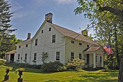
- The William Gibbons Stable and Farm, built Template:Circa, was built by prominent racing patron, William Gibbons to house his thoroughbred racehorses, including Fashion, "Queen of the American Turf".<ref>National Register of Historic Places Registration Form for William Gibbons Stable and Farm, National Park Service. Accessed May 10, 2023.</ref>
-
 Price-Baldwin House
 -
 Lewis Noe Farmstead
 -
 William Gibbons Stable and Farm
 -
 Morris County Heritage Commission sign for the Gibbons Horse Barn


Notable people
Template:Category see also People who were born in, residents of, or otherwise closely associated with Chatham Township include:
- Madame Bey (Template:Circa–1942), Turkish-born opera singer who ran a camp for boxers from 1923 until her death<ref>Rybolt, Barbara. "Madame Bey's boxing training camp was home to 'The Cinderella Man'", Independent Press, August 13, 2009. Accessed July 15, 2016. "The 1914 lightweight boxing champion of the world, Freddie Welsh, started and ran a health farm in Chatham Township. Turkish born Heranoush Bey (known as Madame Bey) took over the reins when Mr. Walsh entered the army in World War I and eventually opened her own boxing camp on River Road."</ref>
- Lincoln Brower (1931–2018), was an American entomologist and ecologist, best known for his research on monarch butterflies<ref>Mytelka, Roz. "Butterflies, Moths and Chatham Township; Lincoln Brower 1931-2018", Chatham Living, August 2019. Accessed February 1, 2022. "Lincoln Brower, foremost expert on Monarch butterflies, grew up in Chatham Township."</ref>
- Dan Canter (born 1961), soccer defender who played three seasons in the North American Soccer League and three in Major Indoor Soccer League, in addition to playing with the United States men's national soccer team<ref>Yannis, Alex. "Canter's Dream Comes True", The New York Times, June 3, 1984. Accessed October 29, 2013. "The 22-year-old Canter, who was born in North Plainfield, N.J., and grew up in Chatham Township, about 30 minutes by car from Giants Stadium, is in his third year in the league and first with the Cosmos."</ref>
- Glenn Davis, sportscaster best known as the lead play-by-play announcer for local TV broadcasts of the Houston Dynamo FC<ref>Naar, Iris A. "Glenn Davis Soccer star chosen All-American", The Chatham Press, January 23, 1983. Accessed February 20, 2025, via Newspapers.com, "From Chatham Township lo West Virginia, Glenn Davis continues to win honors for his performance on the soccer Held. Davis, a Chatham Township High School soccer standout who recently graduated from Davis and Elkins College, has been named to the National Association of Intercollegiate Athletics first team All-American squad."</ref>
- Dave Given (born 1954), former ice hockey right winger who played one game in the World Hockey Association for the Vancouver Blazers<ref>Davie Given, Elite Hockey Prospects. Accessed January 4, 2018. "Birthplace: Summit, NJ, USA.... 1969-70 Chatham Township"</ref>
- Kathleen Hagen (1945–2015), physician who was convicted of murdering her parents by asphyxiation in their Chatham Township home<ref>Lockwood, Jim. "Kathleen Hagen, who killed parents in Chatham home, will be allowed to remain free", The Star-Ledger, July 8, 2010. Accessed July 24, 2018. "A Morris County judge ruled today that a Chatham Township woman who killed her elderly parents a decade ago has improved her mental health and will be allowed to remain free. Judge Thomas Manahan found in a routine review of her case today in Superior Court in Morristown that Kathleen Hagen is complying with orders to continue receiving psychiatric treatment and taking psychotropic medications."</ref>
- Don Herrmann (born 1947), former wide receiver in the National Football League who played for the New York Giants and the New Orleans Saints<ref>Barmakian, Ed. "Don Herrmann is the Only Chatham High Graduate to Play Football in the NFL", TAP into Chatham, August 28, 2017. Accessed July 23, 2018. "Don Herrmann, the kid who grew up on Ramapo Trail in Chatham Township, is the first graduate of Chatham High to make a career in the National Football League."</ref>
- Deep Katdare (born 1970), financier and former actor<ref>"Student News", Daily Record, September 30, 1986. Accessed July 10, 2022, via Newspapers.com. "Delbarton School students Richard Schoenweisner, Florham Park; Phillipp Ellison, Mendham; Deep Katdare, Chatham Township; and Brant Rose, Mendham, were members of the chemistry team that placed first in Morris County in the Jerome Bentley State Science Day Competition."</ref>
- Peter Kuhn (1955–2009), race car driver who won both the USAC and SCCA Formula Super Vee championships in 1980<ref>Staff. "Peter H. Kuhn, accomplished race car driver", Hunterdon County Democrat, June 29, 2009. Accessed August 15, 2016. "Born in Summit, April 14, 1955, he was a son of Jean Henry and Elizabeth 'Lib' Dowd Kuhn. Mr. Kuhn had resided in Franklin Township since 1995, having formerly lived in Basking Ridge and Chatham Township."</ref>
- Alex Laferriere (born 2001), professional ice hockey right winger for the Los Angeles Kings<ref>{{#invoke:citation/CS1|citation
|CitationClass=web }}</ref>
- Dorthy Moxley (1932–2024), educator and crime victim advocate<ref>"Dorthy Moxley feels sympathy but punishment a must for Skakel", New jersey Hills, September 5, 2002. Accessed December 29, 2024. "On Wednesday, Aug. 28, Dorthy Moxley of Chatham Township stood in a Norwalk, Ct., courtroom and urged Superior Court Judge John F. Kavanewsky Jr. to put Michael Skakel in prison for life for murdering her daughter, Martha, on Halloween eve 27 years ago."</ref>
- Drew O'Connor (born 1998), professional ice hockey left winger for the Vancouver Canucks<ref>{{#invoke:citation/CS1|citation
|CitationClass=web }}</ref>
- Andrew Prendeville (born 1981), professional automobile racer<ref>"Nashville: Andrew Prendeville race notes" Template:Webarchive, Motorsport.com, July 13, 2008. Accessed November 5, 2017. "Prendeville, a native of Chatham Township, N.J., started 12th, but he zoomed into the top 10 by the end of lap one."</ref>
- Anne M. Thompson, specialist in atmospheric chemistry<ref>Fleming, Mrs. Paul. "Along the Way", The Chatham Press, April 9, 1970. Accessed January 27, 2022, via Newspapers.com. "Anne Thompson, daughter of Mr. and Mrs. H. T. Thompson of 16 Deer Run Circle, has been awarded a National Science Foundation Graduate Fellowship for physical chemistry at Princeton University. A senior at Swarthmore College, she is a graduate of Chatham Township High School."</ref>
- Billy Walsh (born 1975), former professional soccer player who played for the MetroStars<ref>Yannis, Alex. "Soccer; Great Run Of Rutgers Is Stopped By Virginia", The New York Times, December 10, 1994. Accessed August 6, 2015. "Pollard also started the winning goal, which was scored in the 54th minute by Billy Walsh, a freshman from Chatham Township, N.J."</ref>
References
External links
Template:Chatham, New Jersey Template:Morris County, New Jersey Template:Passaic River