Crown Point (Oregon)
Template:Short description Template:Use American English Template:Use mdy dates Template:Infobox protected area
Crown Point (also known historically as Thor's Heights or Thor's Crown)<ref>Vista House at Crown Point [brochure], 2005.</ref><ref>Vista House, Columbia River Gorge, Oregon, 2006, p. 2.</ref> is a basalt promontory on the Columbia River Gorge and an associated state park in the U.S. state of Oregon. It is located in eastern Multnomah County, approximately Template:Convert east of Portland. Crown Point is one of the scenic lookouts along the Historic Columbia River Highway, providing a panoramic view of part of the Columbia River. It stands Template:Convert above the river and is the remains of a lava flow that filled the ancestral channel of the Columbia River 14 to 17 million years ago.<ref>Template:Cite book</ref><ref name="hill">Template:Cite news</ref> The Point was designated a National Natural Landmark in 1971.<ref>{{#invoke:citation/CS1|citation |CitationClass=web }}</ref>
Vista House
{{#invoke:Labelled list hatnote|labelledList|Main article|Main articles|Main page|Main pages}} The 1918 Art Nouveau style Vista House is an observatory at Crown Point that also serves as a memorial to Oregon pioneers and as a comfort station for travelers on the Historic Columbia River Highway. The site, on a rocky promontory, is Template:Convert above the Columbia River on the south side of the Columbia River Gorge. The building shows great sensitivity to its site in the Columbia River Gorge near Corbett,<ref name=Ritz>Template:Cite encyclopedia</ref> and is listed on the National Register of Historic Places.
-
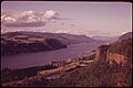
 View from Crown Point looking over the Columbia River Gorge
 -
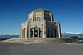 Vista House
 -
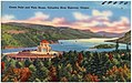 A postcard of Crown Point from circa 1930–1945
 -
 Crown Point in 1973


.jpg)

Crown Point Viaduct
The Crown Point Viaduct, built in 1914, is a viaduct consisting of an elevated sidewalk supported by columns and a retaining wall which encircle the tight loop of roadway around Vista House (1918). The viaduct is a contributing structure in the National Historic Landmarked and National Register of Historic Places-listed Historic Columbia River Highway.<ref name=nhl/> Per the 2000 NHL nomination of the highway:
This Template:Convert spiral viaduct was constructed of reinforced concrete and runs for 225 degrees of a circle around Crown Point. It functions as a Template:Convert sidewalk and curb with a Template:Convert parapet wall on the outside of a Template:Convert roadway cut into the rock formation. A dry masonry retaining wall stabilizes the hillside above and below the viaduct and masonry parapet walls that ring Vista House.<ref name=nhl>{{#invoke:citation/CS1|citation
|CitationClass=web
}} With Template:NRHP url</ref>
See also
- Interstate 84 in Oregon
- List of bridges documented by the Historic American Engineering Record in Oregon
- List of bridges on the National Register of Historic Places in Oregon
- US Route 30 in Oregon
References
External links
- Template:Usurped
- Crown Point State Scenic Corridor Oregon Parks and Recreation Department
- Historic American Engineering Record (HAER) documentation, filed under Troutdale, Multnomah County, OR: