From 1884 to 1968, the town was served by the Fairlie Branch railway,<ref name="therald">"Opening of the Railway to Fairlie Creek", Timaru Herald (31 January 1884): 3.</ref><ref>{{#invoke:citation/CS1|citation
|CitationClass=web
}}</ref> though until 1934, this branch line actually terminated a kilometre beyond Fairlie in Eversley.
Fairlie is commonly known as the gateway to the Mackenzie Basin.<ref>Template:Cite encyclopedia</ref><ref name=":0">{{#invoke:citation/CS1|citation
|CitationClass=web
}}</ref> The town was initially called Fairlie's Creek, a name purportedly chosen by David Hamilton, the brother-in-law of James Lister (or Lizter), who had built a boarding house near the creek. The name Hamilton had been suggested, but was rejected due to similarity to the City of Hamilton in the North Island. David Hamilton suggested the town be named Fairlie after Fairlie, Scotland, which he had visited as part of his honeymoon.<ref>{{#invoke:citation/CS1|citation
|CitationClass=web
}}</ref> After 1892, the town's name was shortened to Fairlie.<ref>{{#invoke:citation/CS1|citation
|CitationClass=web
}}</ref>
Template:Historical populations
Fairlie had a population of 885 at the 2018 New Zealand census, an increase of 24 people (2.8%) since the 2013 census, and an increase of 18 people (2.1%) since the 2006 census. There were 378 households, comprising 435 males and 447 females, giving a sex ratio of 0.97 males per female. The median age was 47.3 years (compared with 37.4 years nationally), with 138 people (15.6%) aged under 15 years, 141 (15.9%) aged 15 to 29, 369 (41.7%) aged 30 to 64, and 234 (26.4%) aged 65 or older.
Ethnicities were 89.5% European/Pākehā, 7.8% Māori, 0.3% Pasifika, 5.8% Asian, and 1.4% other ethnicities. People may identify with more than one ethnicity.
The percentage of people born overseas was 20.3, compared with 27.1% nationally.
Although some people chose not to answer the census's question about religious affiliation, 45.4% had no religion, 44.4% were Christian, 0.3% had Māori religious beliefs, 0.7% were Buddhist and 1.0% had other religions.
Of those at least 15 years old, 105 (14.1%) people had a bachelor's or higher degree, and 189 (25.3%) people had no formal qualifications. The median income was $25,700, compared with $31,800 nationally. 78 people (10.4%) earned over $70,000 compared to 17.2% nationally. The employment status of those at least 15 was that 348 (46.6%) people were employed full-time, 123 (16.5%) were part-time, and 6 (0.8%) were unemployed.<ref name="Census 2018">Template:NZ census 2018</ref>
Template:Historical populations
Opua had a population of 1,347 at the 2018 New Zealand census, an increase of 84 people (6.7%) since the 2013 census, and an increase of 240 people (21.7%) since the 2006 census. There were 501 households, comprising 726 males and 621 females, giving a sex ratio of 1.17 males per female. The median age was 40.0 years (compared with 37.4 years nationally), with 294 people (21.8%) aged under 15 years, 240 (17.8%) aged 15 to 29, 660 (49.0%) aged 30 to 64, and 153 (11.4%) aged 65 or older.
Ethnicities were 95.5% European/Pākehā, 6.0% Māori, 1.1% Pasifika, 2.0% Asian, and 1.6% other ethnicities. People may identify with more than one ethnicity.
The percentage of people born overseas was 12.9, compared with 27.1% nationally.
Although some people chose not to answer the census's question about religious affiliation, 49.7% had no religion, 41.0% were Christian, 0.7% were Hindu, 0.2% were Buddhist and 0.2% had other religions.
Of those at least 15 years old, 165 (15.7%) people had a bachelor's or higher degree, and 192 (18.2%) people had no formal qualifications. The median income was $36,600, compared with $31,800 nationally. 171 people (16.2%) earned over $70,000 compared to 17.2% nationally. The employment status of those at least 15 was that 633 (60.1%) people were employed full-time, 198 (18.8%) were part-time, and 12 (1.1%) were unemployed.<ref name="Census 2018 O">Template:NZ census 2018</ref>
Governance
The Mackenzie District Council provide local government services to Fairlie. The Mackenzie District Council offices are located at 53 Main Street, Fairlie.<ref>{{#invoke:citation/CS1|citation
|CitationClass=web
}}</ref> Fairlie is part of the Waitaki electorate. Miles Anderson of the National Party is the current member of parliament.<ref>{{#invoke:citation/CS1|citation
|CitationClass=web
}}</ref>
Education
Fairlie War Memorial in the town centre (July 2021)
Fairlie hosts the annual Mackenzie District Agricultural and Pastoral show every Easter Monday. The first show was in 1899. The 100th edition ran in 1998. The show has been cancelled three times. Firstly in 1925 because of a polio epidemic, in 1943 due to WWII and 1948 due to an infantile paralysis epidemic.<ref>{{#invoke:citation/CS1|citation
|CitationClass=web
}}</ref>
Ski fields
Fairlie is near the Two Thumb mountain range. There are two ski fields close located nearby. Mount Dobson Ski Field is 28 km drive from Fairlie, as is Fox Peak Ski Field.<ref>{{#invoke:citation/CS1|citation
|CitationClass=web
}}</ref><ref>{{#invoke:citation/CS1|citation
|CitationClass=web
}}</ref>
Golf course
The Fairlie Golf Club is an 18-hole golf course located on Talbot Street.<ref>{{#invoke:citation/CS1|citation
|CitationClass=web
}}</ref> The flat course has a 5526 metre long men's course with par being 70 and a 5017 metre long women's course with par being 72. The Fairlie 500 is a 72-hole tournament which is played on the third weekend of March each year. In April each year, the Glencairn ladies pairs tournament is held.<ref>{{#invoke:citation/CS1|citation
|CitationClass=web
}}</ref>
Rugby
The former Fairlie courthouse
The Mackenzie rugby football club is based in Fairlie at Strathconan Park. It plays in all grades in the South Canterbury Rugby Union competitions.<ref>{{#invoke:citation/CS1|citation
|CitationClass=web
}}</ref> The Fairlie Creek Football Club was established in 1884 and played the rival Albury club two to three times each year initially. The Mackenzie sub union was formed in 1907 after the formation of the Cricklewood Club in 1907. Two other teams, Cave in 1911 and Alpine in 1912, also joined the Mackenzie sub union. After World War II, Tekapo and Pukaki also joined the Mackenzie sub union. In 1953, after the retirement of a number of players, the various clubs merged to form the Mackenzie rugby football club.<ref>{{#invoke:citation/CS1|citation
|CitationClass=web
}}</ref>
Swimming pool
The Strathconan pool is located on School Road, Fairlie. It is open between October and March each year. The facility includes a 25-metre heated indoor swimming pool.<ref>{{#invoke:citation/CS1|citation
|CitationClass=web
}}</ref> Management of the pool was transferred from the Mackenzie District Council to Belgravia Leisure for the 2020–2021 season.<ref>{{#invoke:citation/CS1|citation
|CitationClass=web
}}</ref>
Ice skating
The Fairlie Ice Rink is located between the Fairlie Domain and the Fairlie Campground. The ice rink is based on a man made pond and is reliant on cold weather which determines the length of the ice skating season. The location of the ice rink is two degrees Celsius colder than the town. The ice rink has been operating since the 1930s.<ref>{{#invoke:citation/CS1|citation
|CitationClass=web
}}</ref><ref>{{#invoke:citation/CS1|citation
|CitationClass=web
}}</ref>
Half marathon
The Mackenzie Half-Marathon which first ran in July 2020 starts in Fairlie. 355 runners competed. The second edition ran in July 2021. The course includes a river crossing.<ref>{{#invoke:citation/CS1|citation
|CitationClass=web
}}</ref><ref>{{#invoke:citation/CS1|citation
|CitationClass=web
}}</ref>
Skateboarding
A $100,000 skateboard park was proposed for Fairlie.<ref>{{#invoke:citation/CS1|citation
|CitationClass=web
}}</ref> It was finished in early 2021 and would have cost the community significantly more had not 1200 hours of work been completed by local volunteers.<ref>{{#invoke:citation/CS1|citation
|CitationClass=web
}}</ref>
Fairlie heritage museum
Fairlie Heritage Museum (July 2021)
The Fairlie heritage museum contains a collection of farm machinery, as well as many buildings including the old railway station.<ref>{{#invoke:citation/CS1|citation
|CitationClass=web
}}</ref><ref>{{#invoke:citation/CS1|citation
|CitationClass=web
}}</ref> The Fairlie Heritage Museum has one of the biggest vintage wagon and carriage collections in the country.<ref name=":0" />
Notable residents
Jack Lovelock lived in Fairlie between 1919 and 1923. He was dux of the primary section of Fairlie School.<ref>{{#invoke:citation/CS1|citation
|CitationClass=web
}}</ref><ref>{{#invoke:citation/CS1|citation
|CitationClass=web
}}</ref> The Jack Lovelock memorial track is an eight kilometre walking trail in Fairlie, named in his honour.<ref>{{#invoke:citation/CS1|citation
|CitationClass=web
}}</ref>
Climate
Fairlie has mild summers and frosty winters. In summer, temperatures exceed Template:Convert an average of 30 days a year and Template:Convert on a few afternoons most years, while in winter temperatures drop below Template:Convert an average of 113 nights a year.<ref>{{#invoke:citation/CS1|citation
|CitationClass=web
}}</ref>
The Gladstone Grand Hotel is a category two listed building built in 1884.<ref>{{#invoke:citation/CS1|citation
|CitationClass=web
}}</ref>
The Mount Cook Line building (which were formerly stables dating from 1906). This category two building was listed in 1984.<ref>{{#invoke:citation/CS1|citation
|CitationClass=web
}}</ref>
Fairlie is known for its pies produced at the Fairlie Bakehouse.<ref>{{#invoke:citation/CS1|citation
|CitationClass=web
}}</ref><ref>{{#invoke:citation/CS1|citation
|CitationClass=web
}}</ref>
There are two church buildings, St Columba on Main Street and St Stephen's on Kirke Street. They are part of Mackenzie Cooperating Parish, an ecumenical parish.<ref>{{#invoke:citation/CS1|citation
|CitationClass=web
}}</ref><ref>{{#invoke:citation/CS1|citation
|CitationClass=web
}}</ref> Saint Patrick and All Saints Catholic Church is located at 7 Gall Street.<ref>{{#invoke:citation/CS1|citation
|CitationClass=web
}}</ref>
In 2017, Westpac closed their Fairlie branch which left the town without a bank.<ref>{{#invoke:citation/CS1|citation
|CitationClass=web
}}</ref>
Gladstone Grand Hotel (July 2021)
Mt Cook Line Building, next to the Gladstone Grand Hotel (July 2021)
St Columba Church on Main Street (November 2011)
St Patrick's and All Saints Catholic Church (July 2022)


 Gladstone Grand Hotel (July 2021)
 Mt Cook Line Building, next to the Gladstone Grand Hotel (July 2021)
 St Columba Church on Main Street (November 2011)
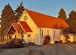 St Patrick's and All Saints Catholic Church (July 2022)
 St Stephen's Anglican Church, Fairlie (July 2022)


