File:Yemeni Civil War.svg
Jump to navigation
Jump to search

Size of this PNG preview of this SVG file: 800 × 522 pixels. Other resolutions: 320 × 209 pixels | 640 × 418 pixels | 1,024 × 669 pixels | 1,280 × 836 pixels | 2,560 × 1,671 pixels | 1,625 × 1,061 pixels.
Original file (SVG file, nominally 1,625 × 1,061 pixels, file size: 945 KB)
Summary
| This file may be updated to reflect new information. If you wish to use a specific version of the file without it being overwritten, please upload the required version as a separate file. |
| Description |
Català: Mapa detallat de l'insurgència al Iemen. Controlat pel Govern liderat per Alimi
Controlat pel Comitè Revolucionari
Controlat pel Consell de Transicó del Sud.
Controlat per Ansar al-Sharia/AQPA forces
Controlat per l'Estado Islàmic(IS)
Controlat per forces lleials a Ali Abdullah Saleh.
Controlat per forces locals no alineades com l' Aliança Tribal Hadhramaut. Deutsch: Detaillierte Karte des Bürgerkriegs im Jemen. Kontrolliert durch Anhänger von Abed Rabbo Mansur Hadi. (Rot)
Kontrolliert durch die Huthi. (Hellgrün)
Kontrolliert durch den Südübergangsrat. (Ocker)
Kontrolliert durch al-Qaida auf der Arabischen Halbinsel. (Weiß)
Kontrolliert durch den Islamischen Staat. (Grau)
Kontrolliert durch Anhänger von Ali Abdullah Salih. (Hellblau)
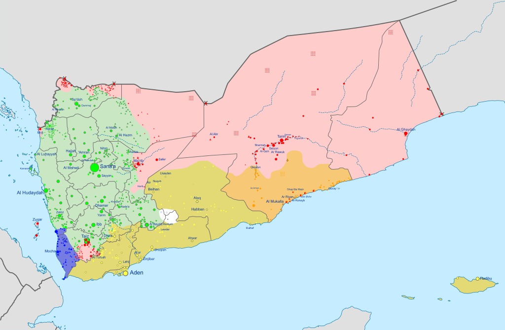
Kontrolliert durch die Elitetruppen der Hadrami. (Orange) English: Insurgency in Yemen detailed Map according to published reports. This map's information is sometimes based on w:Module:Yemeni Civil War detailed map. For sources, see that page's history and talk page. For a visual representation of the data, see that module's documentation page. Controlled by Presidential Leadership Council-led government.
Controlled by the w:Houthi's w:Supreme Political Council.
Controlled by Southern Transitional Council.
Controlled by Ansar al-Sharia/AQAP forces.
Controlled by Hadrami Elite Forces.
Controlled by Tareq Saleh's National Resistance Forces. Español: Mapa detallado de la insurgencia en Yemen. Controlado por el Gobierno liderado por Alimi
Controlado por el Comité Revolucionario
Controlado por el Southern Transitional Council.
Controlado por Ansar al-Sharia/AQPA forces
Controlado por el Estado Islámico (EI) Français : Conflit au Yémen, d'après une carte de Mark Monmonier. Territoire contrôlé par les loyalistes du gouvernement Alimi.
Territoire contrôlé par les Houthis.
Territoire contrôlé par le Conseil de transition du Sud.
Territoire contrôlé par les Forces d'élite hadhramies.
Territoire contrôlé par la Résistance nationale
Territoire contrôlé par les djihadistes d'Ansar al-Sharia/AQAP. Italiano: Mappa dettagliata della situazione attuale in Yemen. Controllato dalle truppe di w:it:Rashad al-Alimi
Controllato dal w:it:Comitato Rivoluzionario
Controlled by Southern Transitional Council.
Controllato da w:it:Ansar al-Sharia/AQPA forces
Controllato dallo w:it:Stato Islamico
Controlled by local, non-aligned forces like the Hadhramaut Tribal Alliance. Nederlands: Gedetailleerde kaart van de Jeministische Burgeroorlog (2015). Gecontroleerd door Hadi-led government.
Gecontroleerd door Revolutionary Committee.
Gecontroleerd door Southern Transitional Council.
Gecontroleerd door Ansar al-Sharia/AQAP forces.
Gecontroleerd door de Islamic State (IS).
Gecontroleerd door lokale, niet aangesloten groep zoals Hadhramaut Tribal Alliance. Português: Insurgência no {{w:pt|Iémen}} mapa detalhado de acordo com relatórios publicados. Controlado pelo Governo liderado pelo Conselho de Liderança Presidencial.
Controlado pelo :Comitê Revolucionário.
Controlado pelo Conselho de Transição do Sul.
Controlado pelo Ansar al-Sharia/AQAP.
Controlado pelo Estado Islâmico (IS).
Controlado por forças locais e não-alinhadas, como a Aliança Tribal de Hadramaute. Ελληνικά: Η κατάσταση στον Υεμενικό Εμφύλιο Πόλεμο, όπως έχει διαμορφωθεί σύμφωνα με δημοσιεύματα. Controlled by Alimi-led government.
Περιοχή ελεγχόμενη από την Επαναστατική Επιτροπή.
Περιοχή ελεγχόμενη από την κυβέρνηση Χάντι και το Νότιο Κίνημα.
Περιοχή ελεγχόμενη από δυνάμεις των οργανώσεων Ανσάρ αλ-Σαρία/Αλ Κάιντα.
Περιοχή ελεγχόμενη από το Ισλαμικό Κράτος.
Controlled by forces loyal to Ali Abdullah Saleh.
Controlled by local, non-aligned forces like the Hadhramaut Tribal Alliance. Русский: Подробная карта мятежа в Йемене. Под контролем Правительства Хади в изгнании.
Под контролем Ансар Аллах
Под контролем Южного Переходного Совета.
Под контролем Аль-Каиды на Аравийском полуострове.
Под контролем Исламского государства Ирака и Леванта (ИГИЛ).
Под контролем местных сил.
Под контролем племён Хадрамауты. Українська: Детальна мапа повстання в Ємені згідно з опублікованими доповідями. Інформація на цій карті частково взята з w:Module:Yemeni Civil War detailed map. Щоб переглянути джерела sources, перегляньте історію цієї сторінки і сторінку обговорення. Щоб побачити візуальну репрезентацію даних, see that module's documentation page. Контролюється Hadi-led government.
Контролюється by Revolutionary Committee.
Контролюється Південною Перехідною Радою.
Контролюється Ansar al-Sharia/AQAP forces.
Контролюється ІДІЛ (IS).
Контролюється місцевими, non-aligned формуваннями, наприклад Hadhramaut Tribal Alliance. 한국어: 예멘 반란 상세지도. 예멘 정부 통치 하의 지역.
후티 반군과 살레정부군 통치 하의 지역.
남예멘 분리주의자(남부과도위원회) 통치 하의 지역.
알카에다 통치 하의 지역.
이슬람 국가(IS) 통치 하의 지역.
Controlled by local, non-aligned forces like the Hadhramaut Tribal Alliance. 日本語: イエメン内戦の勢力図。 ハーディー大統領政権(イエメン政府)支配下の地域
最高政治評議会(フーシ派)支配下の地域
南部暫定評議会支配下の地域
アラビア半島のアルカーイダ傘下のアンサル・アルシャリア支配下の地域
IS支配下の地域
ハドラマウト部族同盟のような地域の非同盟勢力支配下の地域 中文: 也门局势地图。 也门总统阿卜杜拉布·曼苏尔·哈迪支持者控制。
胡塞武装和薩利赫的支持者控制。
南方過渡委員會控制。
伊斯兰国控制区。
哈德拉毛部落联盟(Hadhramaut Tribal Alliance)等当地势力控制。 اردو : یمنی خاناجنگی کی صورتحال. صابق صدر، منصور ہادی کے حامیوں کے قبضے میں.
حوثی باغیوں اور علی عبدالله صالح کے حامیوں کے قبضے میں.
Controlled by Southern Transitional Council.
القاعدہ کے قبضے میں.
Controlled by the Islamic State (IS).
Controlled by local, non-aligned forces like the Hadhramaut Tribal Alliance. العربية : النزاع في اليمنː تسيطر عليها حكومة الرئيس عبد ربه منصور هادي.
تحت سيطرة الحوثيون.
تحت سيطرة المجلس الانتقالي الجنوبي.
تحت سيطرة تنظيم القاعدة في جزيرة العرب القاعدة و أنصار الشريعة.
تحت سيطرة داعش أو موالون لها
تحت سيطرة المقاومة الوطنية اليمنية.
تحت سيطرة قوات النخبة الحضرمية وقوات محلية مثل تحالف حضرموت القبلي. فارسی : نقشهٔ جزئیات درگیریهای جنگ داخلی یمن. در دست نیروهای هوادار منصور هادی.
در دست انصارالله.
در دست مجلس انتقالی جنوب.
در دست القاعده یا انصارالشریعه (وفادار به داعش).
Controlled by the Islamic State (IS).
Controlled by local, non-aligned forces like the Hadhramaut Tribal Alliance. |
||||
| Date | |||||
| Source |
Citing Sana'a Center for Strategic Studies via Al Jazeera, 9 December 2025. Houthi territory per Critical Threats. STC-PLC frontline per Foreign Affairs. Derivative of: Yemen location map.svg by NordNordWest. Borysk5, CC BY-SA 4.0 |
||||
| Author | Ali Zifan | ||||
| Other versions |
 |
||||
| SVG development |


.svg)


.svg)

.svg)
.svg)


_Territory_Change_2014-2016.gif)

_(within_Northern_Syria).svg)


.png)
.svg)


_map.png)
.svg)
.svg)


.svg)


Licensing
I, the copyright holder of this work, hereby publish it under the following license:
This file is licensed under the Creative Commons Attribution-Share Alike 4.0 International license.
- You are free:
- to share – to copy, distribute and transmit the work
- to remix – to adapt the work
- Under the following conditions:
- attribution – You must give appropriate credit, provide a link to the license, and indicate if changes were made. You may do so in any reasonable manner, but not in any way that suggests the licensor endorses you or your use.
- share alike – If you remix, transform, or build upon the material, you must distribute your contributions under the same or compatible license as the original.
File history
Click on a date/time to view the file as it appeared at that time.
| Date/Time | Thumbnail | Dimensions | User | Comment | |
|---|---|---|---|---|---|
| current | 20:37, 21 December 2025 | | 1,625 × 1,061 (945 KB) | wikimediacommons>Ecrusized | Size fix. |
File usage
The following 4 pages use this file: