Great Bear Lake
Template:Short description Template:For Template:Use dmy dates Template:Use Canadian English Template:Infobox body of water
Great Bear Lake (Template:Langx; Template:Langx) in the boreal forest of Canada is the largest lake entirely in Canada (Lake Superior and Lake Huron are larger but straddle the Canada–US border), the fourth-largest in North America, and the eighth-largest in the world.<ref>{{#invoke:citation/CS1|citation |CitationClass=web }}</ref> The lake is in the Northwest Territories, on the Arctic Circle between 65 and 67 degrees of northern latitude and between 118 and 123 degrees western longitude, Template:Cvt above sea level. It drains into the Great Bear River, thence into the Mackenzie River.
The name originated from the Chipewyan word {{#invoke:Lang|lang}}, meaning "grizzly bear-water people".<ref>{{#invoke:citation/CS1|citation |CitationClass=web }}</ref> The Sahtu, a Dene people, are named after the lake. Grizzly Bear Mountain, or Sahoyue, on the shore of the lake also comes from Chipewyan, meaning "bear-large hill".<ref name = Johnson>Johnson, L. The Great Bear Lake: Its Place in History Template:Webarchive. Calgary, Alberta: Arctic Institute of North America (AINA) database at the University of Calgary. pp. 236-237. Retrieved on: 30 January 2012.</ref><ref>{{#invoke:citation/CS1|citation |CitationClass=web }}</ref>
Sahoyue (Grizzly Bear Mountain), a peninsula on the south side of the lake, and Edacho (Scented Grass Hills), another peninsula on the west side, form the Saoyú-ʔehdacho National Historic Site of Canada.<ref>{{#invoke:citation/CS1|citation |CitationClass=web }}</ref><ref>{{#invoke:citation/CS1|citation |CitationClass=web }}</ref>
Geography
.png)

The lake has a surface area of Template:Cvt and a volume of Template:Cvt. Its maximum depth is Template:Cvt and average depth Template:Cvt. The shoreline is Template:Cvt and the catchment area of the lake is Template:Cvt.<ref>{{#invoke:citation/CS1|citation |CitationClass=web }}</ref> Great Bear Lake is covered with ice from late November to July.<ref name=EoEarth/>
The lake is known for its considerable clarity. Explorer John Franklin wrote in 1828 that a white rag placed in the water did not disappear until it exceeded a depth of Template:Convert.<ref>Template:Cite book</ref>
Arms
Arms of Great Bear Lake include the Smith Arm (northwest), the Dease Arm (northeast), the McTavish Arm (southeast), the McVicar Arm (south) and the Keith Arm (southwest). The community of Délı̨nę is located on the Keith Arm near the outflow of the Great Bear River that flows west into the Mackenzie River at Tulita.<ref name= "Atlas of Canada">{{#invoke:citation/CS1|citation |CitationClass=web }}</ref>
Tributaries
Rivers flowing into Great Bear Lake include the Whitefish River,<ref>Template:Cite cgndb</ref> Big Spruce River,<ref>Template:Cite cgndb</ref> Haldane River,<ref>Template:Cite cgndb</ref> Bloody River,<ref>Template:Cite cgndb</ref> Sloan River,<ref>Template:Cite cgndb</ref> Dease River<ref>Template:Cite cgndb</ref> and the Johnny Hoe River.<ref>Template:Cite cgndb</ref>
Geology and geomorphology
Great Bear Lake lies between two major physiographic regions: the Kazan Uplands portion of the Canadian Shield and the Interior Plains. It was part of glacial Lake McConnell in the pre-glacial valleys reshaped by ice erosion during the Pleistocene. Since, the lake has changed from post-glacial rebound following the ice melting. Precambrian rocks of the Canadian Shield form the eastern margin of the McTavish Arm. These rocks of the Precambrian are sedimentary and metamorphic deposits supplemented by igneous intrusions forming dikes and sills.<ref>{{#invoke:citation/CS1|citation |CitationClass=web }}</ref>
Climate
Human use
The community of Délı̨nę is on the lake, near the headwaters of the Bear River.<ref>{{#invoke:citation/CS1|citation |CitationClass=web }}</ref> There is an ice crossing from Délı̨nę to the winter road on the far side of the Great Bear River.<ref>{{#invoke:citation/CS1|citation |CitationClass=web }}</ref><ref>{{#invoke:citation/CS1|citation |CitationClass=web }}</ref>
On 5 March 2016, a tank truck fell partway through the ice road just a few days after the government had increased the allowed maximum weight limit to Template:Cvt on the road.<ref>{{#invoke:citation/CS1|citation |CitationClass=web }}</ref> The truck, which was Template:Cvt outside of Délı̨nę and close to the community's fresh water intake, as well as a major fishing area, contained approximately Template:Cvt of heating fuel and was one of 70 truck loads intended to resupply the community.<ref>{{#invoke:citation/CS1|citation |CitationClass=web }}</ref> The fuel was removed from the truck by 2 am, 8 March.<ref>{{#invoke:citation/CS1|citation |CitationClass=web }}</ref>
Three lodges around the lake are destinations for fishing and hunting.<ref name=EoEarth/> In 1995, a Template:Cvt lake trout was caught, the largest ever caught anywhere by angling.<ref>{{#invoke:citation/CS1|citation |CitationClass=web }}</ref>
Mining
In 1930, Gilbert LaBine discovered uranium deposits in the Great Bear Lake region.<ref>{{#invoke:citation/CS1|citation |CitationClass=web }}</ref> The former mining area Port Radium, site of the Eldorado Mine, where pitchblende was discovered, was located on the eastern shore. Echo Bay Mines Limited leased the old camp and mill at Port Radium to recover silver and copper values from 1965 to 1981.<ref name="A">Template:Cite book</ref>
Cultural significance
Prophecy
Great Bear Lake is paramount in the Délı̨nę peoples' identity, laws and culture. Hence, conserving it is critical for the Délı̨nę people. ɂehtsǝ́o Erǝ́ya, a Dene Elder, is widely regarded as a prophet, making over 30 prophecies which have been interpreted as having come true.<ref>{{#invoke:citation/CS1|citation |CitationClass=web }}</ref> His prediction for the end of times claims that, as the world dries up, the little remaining life will flock to and end on the banks of the Great Bear Lake, a lake seen as a physical beating heart to humanity.<ref>Sakardi, L. (26 December 2017). Inside the fight to protect the Arctic’s “Water Heart”. Retrieved from Canadian Geographic</ref> The Délı̨nę people have followed these prophecies closely, the cultural considerations being a driving force for self-governance and environmental sustainability.<ref>inchey, G., & Kyle, K. (31 August 2016). Deline set to launch historic self-government, 20 years in the making Retrieved from CBC News</ref>
Gallery
-
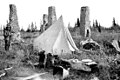 Ruins of Fort Confidence at the mouth of the Dease River in 1911
 -
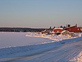 The community of Délı̨nę on Great Bear Lake
 -
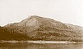 Grizzly Bear Mountain, Great Bear Lake
 -
 Smoke from forest fires in Alaska blows over Great Bear Lake
 -
 Great Bear Lake. Note the smoke plumes from wildfires


Notes
References
External links
Template:Northwest Territories hydrography Template:Northwest Territories parks Template:Authority control