Greenway footpath, London
Template:Short description Template:About Template:Use dmy dates Template:Use British English

<mapframe latitude="51.525193" longitude="0.009613" zoom="11" width="200" height="100" align="right"> {
 "type": "FeatureCollection",
 "features": [
   {
     "type": "Feature",
     "properties": {},
     "geometry": {
       "type": "LineString",
       "coordinates": [
         [
           -0.024483203887939457,
           51.53751372292137
         ],
         [
           -0.021221637725830078,
           51.53673960674539
         ],
         [
           -0.018668174743652347,
           51.536392584875315
         ],
         [
           -0.015084743499755861,
           51.535711880445206
         ],
         [
           -0.013330578804016115,
           51.53531479815979
         ],
         [
           -0.013400316238403322,
           51.535137945270606
         ],
         [
           -0.013582706451416017,
           51.53501114466297
         ],
         [
           -0.012665390968322756,
           51.534216964401864
         ],
         [
           -0.012300610542297365,
           51.53444387446179
         ],
         [
           -0.011892914772033691,
           51.534790911189106
         ],
         [
           -0.011490583419799806,
           51.535141282123924
         ],
         [
           -0.010272860527038576,
           51.53492438614896
         ]
       ]
     }
   },
   {
     "type": "Feature",
     "properties": {},
     "geometry": {
       "type": "LineString",
       "coordinates": [
         [
           -0.010278224945068361,
           51.53492438614896
         ],
         [
           -0.009275078773498535,
           51.534717499794375
         ],
         [
           -0.007692575454711915,
           51.53443386374771
         ],
         [
           -0.006989836692810059,
           51.53420027979397
         ]
       ]
     }
   },
   {
     "type": "Feature",
     "properties": {},
     "geometry": {
       "type": "LineString",
       "coordinates": [
         [
           -0.006995201110839845,
           51.534196942871674
         ],
         [
           -0.006571412086486817,
           51.53413687822829
         ],
         [
           -0.006421208381652833,
           51.53401674870372
         ],
         [
           -0.006051063537597656,
           51.53384990161591
         ],
         [
           -0.0054824352264404306,
           51.53358961893777
         ],
         [
           -0.0050693750381469735,
           51.53341609632549
         ]
       ]
     }
   },
   {
     "type": "Feature",
     "properties": {},
     "geometry": {
       "type": "LineString",
       "coordinates": [
         [
           -0.005058646202087403,
           51.53340274840484
         ],
         [
           -0.002832412719726563,
           51.532321553833874
         ],
         [
           0.0003647804260253907,
           51.53086657246174
         ],
         [
           0.0028967857360839844,
           51.5303593203175
         ]
       ]
     }
   },
   {
     "type": "Feature",
     "properties": {},
     "geometry": {
       "type": "LineString",
       "coordinates": [
         [
           0.0028753280639648438,
           51.5303593203175
         ],
         [
           0.0055146217346191415,
           51.52997220303645
         ],
         [
           0.011136531829833984,
           51.53026587851656
         ],
         [
           0.012638568878173828,
           51.52965182762485
         ],
         [
           0.01471996307373047,
           51.52873073575804
         ],
         [
           0.012681484222412111,
           51.529638478600425
         ],
         [
           0.020384788513183597,
           51.526287749684904
         ],
         [
           0.022616386413574222,
           51.52556684350165
         ]
       ]
     }
   },
   {
     "type": "Feature",
     "properties": {},
     "geometry": {
       "type": "LineString",
       "coordinates": [
         [
           0.022745132446289066,
           51.52554014305346
         ],
         [
           0.024032592773437503,
           51.52523308677373
         ],
         [
           0.02774477005004883,
           51.524739122326764
         ],
         [
           0.03012657165527344,
           51.52441871009053
         ]
       ]
     }
   },
   {
     "type": "Feature",
     "properties": {},
     "geometry": {
       "type": "LineString",
       "coordinates": [
         [
           0.03012657165527344,
           51.52440535953175
         ],
         [
           0.043580532073974616,
           51.522683104628875
         ]
       ]
     }
   },
   {
     "type": "Feature",
     "properties": {},
     "geometry": {
       "type": "LineString",
       "coordinates": [
         [
           0.043580532073974616,
           51.522683104628875
         ],
         [
           0.05632638931274415,
           51.52106759702744
         ],
         [
           0.05842924118041993,
           51.520747158956674
         ],
         [
           0.059008598327636726,
           51.52077386221535
         ],
         [
           0.059373378753662116,
           51.52058693907577
         ],
         [
           0.05984544754028321,
           51.52005286873513
         ],
         [
           0.06085395812988282,
           51.52052018062571
         ],
         [
           0.06585359573364259,
           51.51986594263629
         ],
         [
           0.07261276245117189,
           51.518944652797195
         ]
       ]
     }
   },
   {
     "type": "Feature",
     "properties": {},
     "geometry": {
       "type": "LineString",
       "coordinates": [
         [
           0.0594162940979004,
           51.52058693907577
         ],
         [
           0.06804227828979494,
           51.523817931070674
         ],
         [
           0.06945848464965822,
           51.52423180191153
         ]
       ]
     }
   }
 ]
} </mapframe>
The Greenway is a Template:Convert long<ref name=":0">{{#invoke:citation/CS1|citation |CitationClass=web }}</ref><ref>{{#invoke:citation/CS1|citation |CitationClass=web }}</ref><ref>{{#invoke:citation/CS1|citation |CitationClass=web }}</ref> footpath<ref name="nyoung">{{#invoke:citation/CS1|citation |CitationClass=web }}</ref> and cycleway<ref>{{#invoke:citation/CS1|citation |CitationClass=web }}</ref> in London, mostly in the London Borough of Newham, on the embankment containing the Joseph Bazalgette<ref>{{#invoke:citation/CS1|citation |CitationClass=web }}</ref> Northern Outfall Sewer.
Route
Template:Greenway RDT The western end of the Greenway is Victoria Park, London (London Borough of Tower Hamlets). The route runs alongside Wick Lane, under the East Cross Route to Fish Island.<ref>{{#invoke:citation/CS1|citation |CitationClass=web }}</ref> It then crosses the River Lea into Newham, continuing to Stratford and West Ham.<ref>{{#invoke:citation/CS1|citation |CitationClass=web }}</ref> The eastern end is at Royal Docks Road in Beckton.<ref>{{#invoke:citation/CS1|citation |CitationClass=web }}</ref>
The Capital Ring Walk (section 14) follows the Greenway for most of its distance, and forms part 4<ref>{{#invoke:citation/CS1|citation |CitationClass=web }}</ref> of the 2012 Jubilee Greenway<ref name="xport">{{#invoke:citation/CS1|citation |CitationClass=web }}</ref>
The western half of the Greenway embankment is roughly at house eaves height giving a view over the surrounding flat area (see gallery pictures). Between Stratford High Street and Beckton the route is flat. There is a renewed tarmac surface along its full length, with grass kept short on either side and bushes/trees on the embankment sides. The tarmac area is the width of a narrow two way road allowing easy passing of pedestrians and cyclists, with approx the same width of grass on either side.<ref name="bdonline">{{#invoke:citation/CS1|citation |CitationClass=web }}</ref>
The Greenway and several surrounding areas have been recognised by the Mayor of London and the London boroughs as a Site of Importance for Nature Conservation (SINC) since 2016.<ref>{{#invoke:citation/CS1|citation |CitationClass=web }}</ref><ref>{{#invoke:citation/CS1|citation |CitationClass=web }}</ref><ref>{{#invoke:citation/CS1|citation |CitationClass=web }}</ref>
In mid-2018, Transport for London designated the section of the Greenway between the A13 and A118 as Quietway 22.<ref>{{#invoke:citation/CS1|citation |CitationClass=web }}</ref>
A similar path called the Ridgeway covers the Southern Outfall Sewer.
Renovation

Work has taken place to resurface and renovate the route—especially around the Olympic Park.<ref>Template:Cite news</ref><ref>Template:Cite news</ref>
A community group was set up in 2016 for Greenway users,<ref>{{#invoke:citation/CS1|citation |CitationClass=web }}</ref><ref>{{#invoke:citation/CS1|citation |CitationClass=web }}</ref> and Newham Council began piloting better lighting,<ref>{{#invoke:citation/CS1|citation |CitationClass=web }}</ref> with a view to opening the Greenway 24 hours a day.<ref name=":0" /> Greenway Users have subsequently set up a Greenway Action Group to improve the recording of incidents by logging crimes on the pathway.<ref>{{#invoke:citation/CS1|citation |CitationClass=web }}</ref>
The renovation of the Greenway was finished in July 2019, after the completion of major water supply works by Thames Water along the western half and the opening of the bridges over the Waterworks River and the City Mill River.<ref>{{#invoke:citation/CS1|citation |CitationClass=web }}</ref>
In 2022, the Greenway was the site of one of 19 projects selected by the Mayor of London's Rewild London Fund to help 'rewild the city and recover nature'.<ref>{{#invoke:citation/CS1|citation |CitationClass=web }}</ref><ref>{{#invoke:citation/CS1|citation |CitationClass=web }}</ref><ref>{{#invoke:citation/CS1|citation |CitationClass=web }}</ref><ref>{{#invoke:citation/CS1|citation |CitationClass=web }}</ref>
The View Tube,<ref>{{#invoke:citation/CS1|citation |CitationClass=web }}</ref> made from recycled shipping containers, is a viewing platform on the Greenway incorporating the Container Café.<ref>Template:Cite news</ref>
Bow Goods yard, a large plot of land situated between the Greenway and the railway tracks between Stratford and central London is set to become a rail freight campus and last-mile logistics hub. <ref>{{#invoke:citation/CS1|citation |CitationClass=web }}</ref><ref>{{#invoke:citation/CS1|citation |CitationClass=web }}</ref>
History
The older alternative name for the route is Sewerbank, with the name Greenway introduced after a renovation in the mid-1990s.<ref name=":0" />
In 1931 Mahatma Gandhi visited London for a period of 3 months for talks on the future of India, he based himself at Kingsley Hall in Bromley-by-Bow. His host there, the Christian Socialist Muriel Lester described his long early morning walks, beginning before sunrise, and which often took in the Sewerbank through Stratford to Plaistow. Gandhi enjoyed the elevated view the bank offered, and on these walks he would always gather a collection of well-wishers eager to speak to him.<ref>Gandhi's host at Kinsley Hall, Muriel Lester, described these walks in her account of his 3 month stay with her {{#invoke:citation/CS1|citation |CitationClass=web }}</ref>
Gallery
-
 Greenway bridge over the River Lea looking north
 -
 Greenway junction with Stratford High Street (A118) looking west
 -
 Northern Outfall Sewer (Greenway) over Manor Road A1011
 -
 London Greenway footpath looking towards Canary Wharf
 -
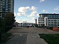
 Greenway footpath, London looking south east
 -
 Greenway footpath, London looking at Abbey Mills pumping station
 -
 Greenway overlooking Brampton Manor Academy
 -
 Greenway overlooking Newham University Hospital
 -
 Greenway entrance at Newham Way (A13) looking east

_looking_west.jpg)
_over_Manor_Road_A1011.jpg)


_looking_east.jpg)