Guadalupe Peak
Template:Short description Template:Use mdy dates Template:Infobox mountain Guadalupe Peak, also known as Signal Peak,<ref>{{#invoke:citation/CS1|citation |CitationClass=web }}</ref> is the highest natural point in Texas,<ref>{{#invoke:citation/CS1|citation |CitationClass=web }}</ref> with an elevation of Template:Convert above sea level.<ref name=ngs/> It is located in Guadalupe Mountains National Park, and is part of the Guadalupe Mountains range in southeastern New Mexico and West Texas. The mountain is about Template:Convert east of El Paso and about Template:Convert southwest of Carlsbad, New Mexico. The peak rises more than Template:Convert above the arid floor of the Chihuahuan Desert.
Trail and summit
The peak can be climbed at any time of the year by a maintained stony trail (Template:Convert each way) with a Template:Convert elevation gain.<ref>{{#invoke:citation/CS1|citation |CitationClass=web }}</ref> The trail is part of the network of hiking trails in the surrounding national park.
A stainless steel pyramid marks the summit. It was erected by American Airlines in 1958 to commemorate the 100th anniversary of the Butterfield Overland Mail, a stagecoach route that passed south of the mountain. One side of the pyramid has the American Airlines logo. The second side displays a U.S. Postal Service tribute to the Pony Express Riders of the Butterfield Stage. The third side displays a compass with the logo of the Boy Scouts of America.
Template:Wide image Template:Clear left
A hiker was found dead on New Year's Eve 2022, as there were wind gusts of more than Template:Convert per hour and wind chills were "well below freezing".<ref>{{#invoke:citation/CS1|citation |CitationClass=web }}</ref><ref>{{#invoke:citation/CS1|citation |CitationClass=web }}</ref><ref>{{#invoke:citation/CS1|citation |CitationClass=web }}</ref>
"At nearly Template:Convert above sea level, Guadalupe Peak is a mountain environment with associated risks not found elsewhere in Texas," the park said, noting that the hike is a "very strenuous, Template:Convert round trip hike with a Template:Convert elevation gain" to the highest point in the state.
Climate
Guadalupe Peak has a subtropical highland climate (Köppen Cwb). Interpolated climate data based on surrounding stations is presented below:
Gallery
-
 View west from top of peak.
 -
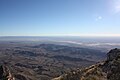
 Salt Flats from summit.
 -
 Guadalupe Mountains in sunset.
 -
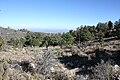
 Hiking trail up the peak.
 -
 High elevation (Template:Convert) campground near summit.
 -
 Culberson County, Texas, from the summit.
 -
 The pyramid at the summit.


See also
References
External links
- {{#invoke:citation/CS1|citation
|CitationClass=web }}
- Template:Cite gnis
- Template:Cite summitpost
- {{#invoke:citation/CS1|citation
|CitationClass=web }}
Template:US isolated Template:U.S. State Highest Points Template:US state navigation box Template:Mountains of Texas