Hamarøy Municipality
Template:Short description Template:Main other{{#invoke:Infobox|infobox}}Template:Template other{{#invoke:Check for unknown parameters|check|unknown=Template:Main other|preview = Page using [[Template:Template:If empty]] with unknown parameter "_VALUE_"|ignoreblank=y|mapframe_args=y | alt | anthem | anthem_link | area_blank1_acre | area_blank1_dunam | area_blank1_ha | area_blank1_km2 | area_blank1_sq_mi | area_blank1_title | area_blank2_acre | area_blank2_dunam | area_blank2_ha | area_blank2_km2 | area_blank2_sq_mi | area_blank2_title | area_code | area_code_type | area_codes | area_footnotes | area_land_acre | area_land_dunam | area_land_ha | area_land_km2 | area_land_sq_mi | area_metro_acre | area_metro_dunam | area_metro_footnotes | area_metro_ha | area_metro_km2 | area_metro_sq_mi | area_note | area_rank | area_rural_acre | area_rural_dunam | area_rural_footnotes | area_rural_ha | area_rural_km2 | area_rural_sq_mi | area_total_acre | area_total_dunam | area_total_ha | area_total_km2 | area_total_sq_mi | area_urban_acre | area_urban_dunam | area_urban_footnotes | area_urban_ha | area_urban_km2 | area_urban_sq_mi | area_water_acre | area_water_dunam | area_water_ha | area_water_km2 | area_water_percent | area_water_sq_mi | blank_emblem_alt | blank_emblem_link | blank_emblem_size | blank_emblem_type | blank_emblem_sizedefault | blank_emblem_upright | blank_info | blank_info_sec1 | blank_info_sec2 | blank_name | blank_name_sec1 | blank_name_sec2 | blank1_info | blank1_info_sec1 | blank1_info_sec2 | blank1_name | blank1_name_sec1 | blank1_name_sec2 | blank2_info | blank2_info_sec1 | blank2_info_sec2 | blank2_name | blank2_name_sec1 | blank2_name_sec2 | blank3_info | blank3_info_sec1 | blank3_info_sec2 | blank3_name | blank3_name_sec1 | blank3_name_sec2 | blank4_info | blank4_info_sec1 | blank4_info_sec2 | blank4_name | blank4_name_sec1 | blank4_name_sec2 | blank5_info | blank5_info_sec1 | blank5_info_sec2 | blank5_name | blank5_name_sec1 | blank5_name_sec2 | blank6_info | blank6_info_sec1 | blank6_info_sec2 | blank6_name | blank6_name_sec1 | blank6_name_sec2 | blank7_info | blank7_info_sec1 | blank7_info_sec2 | blank7_name | blank7_name_sec1 | blank7_name_sec2 | caption | code1_info | code1_name | code2_info | code2_name | coor_pinpoint | coor_type | coordinates | coordinates_footnotes | demographics_type1 | demographics_type2 | demographics1_footnotes | demographics1_info1 | demographics1_info10 | demographics1_info2 | demographics1_info3 | demographics1_info4 | demographics1_info5 | demographics1_info6 | demographics1_info7 | demographics1_info8 | demographics1_info9 | demographics1_title1 | demographics1_title10 | demographics1_title2 | demographics1_title3 | demographics1_title4 | demographics1_title5 | demographics1_title6 | demographics1_title7 | demographics1_title8 | demographics1_title9 | demographics2_footnotes | demographics2_info1 | demographics2_info10 | demographics2_info2 | demographics2_info3 | demographics2_info4 | demographics2_info5 | demographics2_info6 | demographics2_info7 | demographics2_info8 | demographics2_info9 | demographics2_title1 | demographics2_title10 | demographics2_title2 | demographics2_title3 | demographics2_title4 | demographics2_title5 | demographics2_title6 | demographics2_title7 | demographics2_title8 | demographics2_title9 | dimensions_footnotes | dunam_link | elevation_footnotes | elevation_ft | elevation_link | elevation_m | elevation_max_footnotes | elevation_max_ft | elevation_max_m | elevation_max_point | elevation_max_rank | elevation_min_footnotes | elevation_min_ft | elevation_min_m | elevation_min_point | elevation_min_rank | elevation_point | embed | established_date | established_date1 | established_date2 | established_date3 | established_date4 | established_date5 | established_date6 | established_date7 | established_title | established_title1 | established_title2 | established_title3 | established_title4 | established_title5 | established_title6 | established_title7 | etymology | extinct_date | extinct_title | flag_alt | flag_border | flag_link | flag_size | footnotes | founder | geocode | governing_body | government_footnotes | government_type | government_blank1_title | government_blank1 | government_blank2_title | government_blank2 | government_blank2_title | government_blank3 | government_blank3_title | government_blank3 | government_blank4_title | government_blank4 | government_blank5_title | government_blank5 | government_blank6_title | government_blank6 | grid_name | grid_position | image_alt | image_blank_emblem | image_caption | image_flag | image_map | image_map1 | image_seal | image_shield | image_size | image_skyline | imagesize | image_sizedefault | image_upright | iso_code | leader_name | leader_name1 | leader_name2 | leader_name3 | leader_name4 | leader_name5 | leader_party | leader_title | leader_title1 | leader_title2 | leader_title3 | leader_title4 | leader_title5 | length_km | length_mi | map_alt | map_alt1 | map_caption | map_caption1 | mapsize | mapsize1 | module | motto | motto_link | mottoes | name | named_for | native_name | native_name_lang | nickname | nickname_link | nicknames | official_name | other_name | p1 | p10 | p11 | p12 | p13 | p14 | p15 | p16 | p17 | p18 | p19 | p2 | p20 | p21 | p22 | p23 | p24 | p25 | p26 | p27 | p28 | p29 | p3 | p30 | p31 | p32 | p33 | p34 | p35 | p36 | p37 | p38 | p39 | p4 | p40 | p41 | p42 | p43 | p44 | p45 | p46 | p47 | p48 | p49 | p5 | p50 | p6 | p7 | p8 | p9 | parts | parts_style | parts_type | pop_est_as_of | pop_est_footnotes | population | population_as_of | population_blank1 | population_blank1_footnotes | population_blank1_title | population_blank2 | population_blank2_footnotes | population_blank2_title | population_demonym | population_demonyms | population_density_blank1_km2 | population_density_blank1_sq_mi | population_density_blank2_km2 | population_density_blank2_sq_mi | population_density_km2 | population_density_metro_km2 | population_density_metro_sq_mi | population_density_rank | population_density_rural_km2 | population_density_rural_sq_mi | population_density_sq_mi | population_density_urban_km2 | population_density_urban_sq_mi | population_est | population_footnotes | population_metro | population_metro_footnotes | population_note | population_rank | population_rural | population_rural_footnotes | population_total | population_urban | population_urban_footnotes | postal_code | postal_code_type | postal2_code | postal2_code_type | pushpin_image | pushpin_label | pushpin_label_position | pushpin_map | pushpin_map_alt | pushpin_map_caption | pushpin_map_caption_notsmall | pushpin_map_narrow | pushpin_mapsize | pushpin_outside | pushpin_overlay | pushpin_relief | registration_plate | registration_plate_type | seal_alt | seal_link | seal_size | seal_type | seat | seat_type | seat1 | seat1_type | seat2 | seat2_type | settlement_type | shield_alt | shield_link | shield_size | short_description | subdivision_name | subdivision_name1 | subdivision_name2 | subdivision_name3 | subdivision_name4 | subdivision_name5 | subdivision_name6 | subdivision_type | subdivision_type1 | subdivision_type2 | subdivision_type3 | subdivision_type4 | subdivision_type5 | subdivision_type6 | template_name | timezone | timezone_DST | timezone_link | timezone1 | timezone1_DST | timezone1_location | timezone2 | timezone2_DST | timezone2_location | timezone3 | timezone3_DST | timezone3_location | timezone4 | timezone4_DST | timezone4_location | timezone5 | timezone5_DST | timezone5_location | total_type | translit_lang1 | translit_lang1_info | translit_lang1_info1 | translit_lang1_info2 | translit_lang1_info3 | translit_lang1_info4 | translit_lang1_info5 | translit_lang1_info6 | translit_lang1_type | translit_lang1_type1 | translit_lang1_type2 | translit_lang1_type3 | translit_lang1_type4 | translit_lang1_type5 | translit_lang1_type6 | translit_lang2 | translit_lang2_info | translit_lang2_info1 | translit_lang2_info2 | translit_lang2_info3 | translit_lang2_info4 | translit_lang2_info5 | translit_lang2_info6 | translit_lang2_type | translit_lang2_type1 | translit_lang2_type2 | translit_lang2_type3 | translit_lang2_type4 | translit_lang2_type5 | translit_lang2_type6 | type | unit_pref | utc_offset | utc_offset_DST | utc_offset1 | utc_offset1_DST | utc_offset2 | utc_offset2_DST | utc_offset3 | utc_offset3_DST | utc_offset4 | utc_offset4_DST | utc_offset5 | utc_offset5_DST | website | width_km | width_mi }}{{#invoke:Check for clobbered parameters|check | template = [[Template:Template:If empty]] | cat = Template:Main other | population; population_total | image_size; imagesize | image_alt; alt | image_caption; caption | settlement_type; type | utc_offset1; utc_offset | timezone1; timezone }}{{#if:
|
}}Template:Main other{{#ifexpr:{{#invoke:ParameterCount|main|mapframe|image_map|image_map1|pushpin_map}} >2 |Template:Main other}}{{#if:1875||Template:Preview warningTemplate:Main other}}{{#if:Hamarøy||Template:Preview warningTemplate:Main other}}{{#invoke:Check for unknown parameters|check | unknown = Template:Main other | preview = Page using Template:Infobox kommune with unknown parameter "_VALUE_" | ignoreblank = y | name | custom_name | label | herad | herred | ladested | fylke | former | child | idnumber | map | county | coordinates | landscape | district | official_name | former_name | former_name1 | former_name2 | other_name | native_name | native_name_lang | image_skyline | image_caption | image_alt | coatofarms | flag | nickname | nicknames | shield_alt | image_blank_emblem | blank_emblem_size | sizemap | mapsize | map_alt | map_caption | sizemap1 | mapsize1 | map_alt1 | map_caption1 | established | preceded | disestablished | succeeded | established2 | preceded2 | disestablished2 | succeeded2 | capital | mayor | mayor_as_of | mayor_party | county_mayor | county_mayor_as_of | county_mayor_party | governor | governor_as_of | governor_party | area | area_footnotes | area_rank | arearank | area_total_km2 | arealand | area_land_km2 | area_water_km2 | areapercent | area_water_percent | elevation_footnotes | elevation_max_m | elevation_min_m | highest_point | lowest_point | lowest_point_ref | highest_point_ref | population | population_total | population_as_of | population_footnotes | populationrank | population_rank | population_density_km2 | populationdensity | population_increase | populationincrease | populationpercent | demonym | demonyms | language | sami_language | other_language | munwebpage | webpage | GDP | GDP_rank | GDP_year | GDP_rank_percent | income_per_capita | income_year | module | coordinates | utm_easting | utm_northing | utm_zone | geo_cat }}
Template:Native name or Template:Native name<ref>{{#invoke:citation/CS1|citation |CitationClass=web }}</ref><ref>{{#invoke:citation/CS1|citation |CitationClass=web }}</ref> is a municipality in Nordland county, Norway. It is part of the traditional district of Salten. The administrative centre of the municipality is the village of Oppeid. Other villages include Drag, Hellmobotn, Innhavet, Karlsøy, Korsnes, Presteid, Skutvika, Tømmerneset, Tranøya, and Ulvsvåg.
The Template:Convert municipality is the 36th largest by area out of the 357 municipalities in Norway. Hamarøy Municipality is the 243rd most populous municipality in Norway with a population of 2,729. The municipality's population density is Template:Convert and its population has increased by about 50% over the previous 10-year period (due to the enlargement of the municipality when part of Tysfjord Municipaltiy became part of Hamarøy in 2020).<ref name="ssb pop">{{#invoke:citation/CS1|citation |CitationClass=web }}</ref><ref name="ssb area">{{#invoke:citation/CS1|citation |CitationClass=web }}</ref>
General information
The municipality of Hamarøy was established on 1 January 1838 (see formannskapsdistrikt law). During the 1960s, there were many municipal mergers across Norway due to the work of the Schei Committee. On 1 January 1964, the part of Hamarøy located on the south side of the Sagfjorden and west of the Veggfjellan mountain (population: 77) was transferred to neighboring Steigen Municipality. On the same date, the Tysnes and Molvik farms (population: 33) was transferred from Hamarøy to the neighboring Tysfjord Municipality.<ref>{{#invoke:citation/CS1|citation |CitationClass=web }}</ref>
On 1 January 2020, the western part of Tysfjord Municipality was merged into Hamarøy Municipality. This occurred because in 2017, it was decided by the Parliament of Norway that the neighboring Tysfjord Municipality would be divided along the Tysfjorden with the eastern half being merged with the neighboring Narvik Municipality and Ballangen Municipality to form a new, larger Narvik Municipality and the remaining western half will be merged with Hamarøy Municipality on the same date.<ref>Template:Cite news</ref><ref>{{#invoke:citation/CS1|citation |CitationClass=web }}</ref>
Name
The municipality (originally the parish) is named after the old Hamarøya island (Template:Langx), which is now a peninsula, since the first Hamarøy Church was built there. The first element is the genitive case of the word Template:Wikt-lang which means "thigh/leg (of an animal)". The last element is Template:Wikt-lang which means "island". This was likely because the island (or a part of it) was shaped in the form of an animal's leg.<ref>Template:Cite book</ref> Historically, the name of the municipality was spelled Hammerø. On 6 January 1908, a royal resolution changed the spelling of the name of the municipality to Hamarøy.<ref>Template:Cite journal</ref>
On 21 January 2011, the national government approved a resolution to add a co-equal, official Sami language name for the municipality: {{#invoke:Lang|lang}}.<ref>{{#invoke:citation/CS1|citation |CitationClass=web }}</ref> The spelling of the Sami language name changes depending on how it is used. It is called {{#invoke:Lang|lang}} when it is spelled alone, but it is {{#invoke:Lang|lang}} when using the Sami language equivalent to "Hamarøy Municipality".<ref name="sami name">{{#invoke:citation/CS1|citation |CitationClass=web }}</ref>
Coat of arms
The original coat of arms was granted on 19 February 1982 and in use until 1 January 2020 when the new arms were put into use. The official blazon is "Azure, a lynx statant guardant argent" (Template:Langx). This means the arms have a blue field (background) and the charge is a lynx. The lynx has a tincture of argent which means it is commonly colored white, but if it is made out of metal, then silver is used. Lynx are common in the area it was chosen for the arms as a symbol for the rich wildlife in the forests of the municipality. The arms were designed by Asbjørn Mathiassen.<ref>{{#invoke:citation/CS1|citation |CitationClass=web }}</ref><ref>{{#invoke:citation/CS1|citation |CitationClass=web }}</ref><ref>{{#invoke:citation/CS1|citation |CitationClass=web }}</ref>
The current coat of arms was adopted in 2019 for use starting on 1 January 2020 after a municipal merger. The blazon is "Azure, a rock carving of two swans argent". This means the arms have a blue field (background) and the charge is a depiction of a 9,000-year-old rock carving of the outlines of two swans. The swans have a tincture of argent which means they are commonly colored white, but if it is made out of metal, then silver is used. The ancient rock carving seen at Dyreberget in Leiknes is a notable historical feature for the municipality. The two swans also symbolize the two cultures of the municipality: Norwegian and Lule Sami. The arms were designed by Ingar Nikolaisen Kuoljok and Dag Winsjansen.<ref>{{#invoke:citation/CS1|citation |CitationClass=web }}</ref><ref>{{#invoke:citation/CS1|citation |CitationClass=web }}</ref>
Churches
The Church of Norway has two parishes ({{#invoke:Lang|lang}}) within Hamarøy Municipality. It is part of the Ofoten prosti (deanery) in the Diocese of Sør-Hålogaland.
| lang}}) | Church name | Location of the church | Year built |
|---|---|---|---|
| Hamarøy | Hamarøy Church | Presteid | 1974 |
| Sagfjord | Sagfjord Church | Karlsøy | 1770 |
| Tømmernes Church | Tømmerneset | 1952 |
Geography
Hamarøy Municipality borders Narvik Municipality to the north, Steigen Municipality to the west, Sørfold Municipality to the south, the Vestfjorden to the northwest, and the country of Sweden to the southeast. The large island of Finnøya is located between the Sagfjorden and the Kaldvågfjorden. The highest point in the municipality is the Template:Convert tall mountain Bjørntoppen.<ref name="elev" />
Lakes in the municipality include Fjerdvatnet, Forsanvatnet, Forsvatnet, Kaldvågvatnet, Kilvatnet, Livsejávrre, Makkvatnet, Reinoksvatnet, Rekvatnet, Rotvatnet, Sandnesvatnet, Skilvatnet, Šluŋkkajávri, and Strindvatnet.
Nature
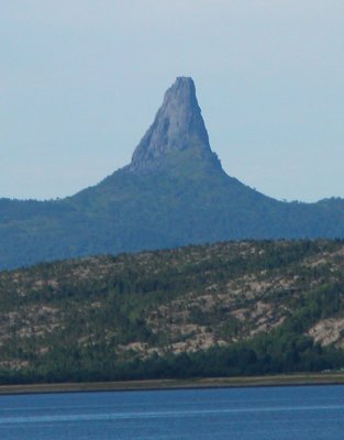
Hamarøy is dominated by small fjords, pine, birch, and aspen woodland and forest, and coastal mountains. There are several nature reserves, such as Trollpollen nature reserve dominated by pine and birch<ref>{{#invoke:citation/CS1|citation |CitationClass=web }}</ref> located a few kilometers north of Innhavet, Lilandsvatnet wetland area,<ref>{{#invoke:citation/CS1|citation |CitationClass=web }}</ref> Steinslandsosen estuary,<ref>{{#invoke:citation/CS1|citation |CitationClass=web }}</ref> and Kvannskogen with old aspen trees with rich lichen flora.<ref>{{#invoke:citation/CS1|citation |CitationClass=web }}</ref> The mountain Hamarøyskaftet has long been regarded as nature's own phallic symbol (See picture 1 and picture 2).
Climate
Hamarøy has an oceanic or boreal climate, depending on winter threshold used (Template:Convert or Template:Convert). The wettest season is autumn and early winter, while April - June is the driest, indicating an oceanic climate. The record high is Template:Convert recorded 18 July 2018 at Drag.
Government
Hamarøy Municipality is responsible for primary education (through 10th grade), outpatient health services, senior citizen services, welfare and other social services, zoning, economic development, and municipal roads and utilities. The municipality is governed by a municipal council of directly elected representatives. The mayor is indirectly elected by a vote of the municipal council.<ref name="ks">Template:Cite SNL</ref> The municipality is under the jurisdiction of the Midtre Hålogaland District Court and the Hålogaland Court of Appeal.
Municipal council
The municipal council ({{#invoke:Lang|lang}}) of Hamarøy Municipality is made up of 17 representatives that are elected to four year terms. The tables below show the current and historical composition of the council by political party. Template:Div col Template:Kommunestyre table Template:Kommunestyre table Template:Kommunestyre table Template:Kommunestyre table Template:Kommunestyre table Template:Kommunestyre table Template:Kommunestyre table Template:Kommunestyre table Template:Kommunestyre table Template:Kommunestyre table Template:Kommunestyre table Template:Kommunestyre table Template:Kommunestyre table Template:Kommunestyre table Template:Kommunestyre table Template:Kommunestyre table Template:Kommunestyre table Template:Kommunestyre table Template:Kommunestyre table Template:Kommunestyre table Template:Kommunestyre table Template:Kommunestyre table Template:Div col end
Mayors
{{ safesubst:#invoke:Unsubst||date=__DATE__ |$B=Template:AmboxTemplate:Main other }} The mayor (Template:Langx) of Hamarøy Municipality was the political leader of the municipality and the chairperson of the municipal council. Here is a list of people who held this position:<ref>{{#invoke:citation/CS1|citation |CitationClass=web }}</ref> Template:Div col
- 1838–18??: Truls Krog Koch
- 1857–1864: Nikolai Walsøe
- 1880–1886: Olaus Holter (H)
- 1887–1899: Andreas Nilsen (V)
- 1908–1910: Joakim E. Winther (V)
- 1911–1919: Johan Hoff Ellingsen (V)
- 1919–1937: Konrad Halmøy (V)
- 1937–1942: Sverre Pedersen (H)
- 1942–1943: Sverre Vaag (NS)
- 1943–1945: Sverre Pedersen
- 1945–1945: Bjarne Gaarder (H)
- 1945–1945: Nordahl Markussen (Ap)
- 1946–1947: Johan Stokland (H)
- 1947–1955: Arthur Thoresen (Ap)
- 1955–1959: Petter Fikke (H)
- 1959–1967: Ulrik Normann (H)
- 1967–1983: Olav Elsbak, Jr. (H)
- 1983–1991: Ingvald Sørensen (Ap)
- 1991–1995: Sverre Harald Eriksen (Sp)
- 1995–2003: May Valle (V)
- 2003–2007: Jan-Folke Sandnes (H)
- 2007–2015: Rolf Steffensen (Ap)
- 2015–2019: Jan-Folke Sandnes (H)<ref>Template:Cite news</ref>
- 2019–present: Britt Kristoffersen Løksa (Sp)
Transportation
While Hamarøy has a low population density, it sees some traffic during the summer months as the main road connection to Svolvær and the Lofoten islands runs through Hamarøy and its administrative centre, Oppeid. The ferry ride to Skrova and Svolvær is approximately 2 hours and departs from Skutvika (approximately 15 minutes from Oppeid) at regular intervals. In 2008, the ferry schedule was considerably reduced due to the new Lofoten Mainland Connection road. The European route E6 highway runs north and south through the municipality on its way to Narvik. Bus service by Stoklands Bilruter is available between certain villages in Hamarøy.
Economy
The municipal administration and other public services are located in Oppeid. There is a hotel in the municipality, as well as the scenic Tranøy Lighthouse which can be rented.<ref>{{#invoke:citation/CS1|citation |CitationClass=web }}</ref>
Skutvik is a small residential and marina area concentrated around the ferry dock. In the high season the number of cars and motor homes in line for the ferry can be significant. There are a few sights to see in Skutvik, as well as a small bar/cafe and a Statoil gas station.
Knut Hamsun
The writer Knut Hamsun, winner of the 1920 Nobel Prize in Literature, grew up in Hamarøy. The Knut Hamsun Centre, a museum and educational center dedicated to Knut Hamsun's life and work, finished building in 2009 and opened for the public in June 2010. Knut Hamsun's childhood home is also open for visitors in summer. The Hamsun literature festival was founded in 1982 and takes place in Hamarøy during the first week of August every second year.
-
Knut Hamsun Centre
-
Knut Hamsun, 1939
Notable people
- Knut Hamsun (1859–1952), a writer and winner of the Nobel Prize in Literature in 1920 who was brought up in Hamarøy
- Sigurd Johan Normann (1879 in Hamarøy — 1939), a theologian and Bishop for the Diocese of Hålogaland in Tromsø from 1937 to 1939
- Tore Hamsun (1912 in Hamarøy – 1995), a painter, writer, and publisher
- Horst Tappert (1923–2008), a German movie and TV actor who had a summer holiday cabin in Hamarøy <ref>[https://www.imdb.com/{{#if: 0850096
 | name/{{#if:{{#invoke:ustring|match|1=0850096|2=^nm}}
   | Template:Trim/
   | nm0850096/
   }}
 | {{#if: {{#property:P345}}
   | name/Template:First word/
   | find?q=%7B%7B%23if%3A+Horst+Tappert%0A++++++%7C+Horst+Tappert%0A++++++%7C+%5B%5B%3ATemplate%3APAGENAMEBASE%5D%5D%0A++++++%7D%7D&s=nm
   }}
 }}{{#if: 0850096  {{#property:P345}} | {{#switch:
 | award | awards = awards Awards for | biography | bio = bio Biography for
 }}}} {{#if: Horst Tappert
 | Horst Tappert
 | Template:PAGENAMEBASE
 }}] at IMDb{{#if: 0850096{{#property:P345}}
 | Template:EditAtWikidata
 | Template:Main other
}}{{#switch:{{#invoke:string2|matchAny|^nm.........|^nm.......|nm|.........|source=0850096|plain=false}}
 | 1 | 3 =  Template:Main otherTemplate:Preview warning
 | 4 = Template:Main otherTemplate:Preview warning
}}{{#invoke:Check for unknown parameters|check|unknown=Template:Main other|preview=Page using Template:IMDb name with unknown parameter "_VALUE_"|showblankpositional=1| 1 | 2 | id | name | section }}. Retrieved 01 September 2020.</ref>
- Jack Berntsen (1940–2010), a philologist, songwriter, and folk singer who grew up in Hamarøy
References
External links
- Municipal fact sheet from Statistics Norway Template:In lang
- The Knut Hamsun Centre
- The Knut Hamsun Centre's architecture
Template:Use dmy dates Template:Sister bar Template:Geographic location {{#invoke:Navbox|navbox}}