Haverford, Pennsylvania
Template:Short description Template:Use American English Template:Use mdy dates Template:Main other{{#invoke:Infobox|infobox}}Template:Template other{{#invoke:Check for unknown parameters|check|unknown=Template:Main other|preview = Page using [[Template:Template:If empty]] with unknown parameter "_VALUE_"|ignoreblank=y|mapframe_args=y | alt | anthem | anthem_link | area_blank1_acre | area_blank1_dunam | area_blank1_ha | area_blank1_km2 | area_blank1_sq_mi | area_blank1_title | area_blank2_acre | area_blank2_dunam | area_blank2_ha | area_blank2_km2 | area_blank2_sq_mi | area_blank2_title | area_code | area_code_type | area_codes | area_footnotes | area_land_acre | area_land_dunam | area_land_ha | area_land_km2 | area_land_sq_mi | area_metro_acre | area_metro_dunam | area_metro_footnotes | area_metro_ha | area_metro_km2 | area_metro_sq_mi | area_note | area_rank | area_rural_acre | area_rural_dunam | area_rural_footnotes | area_rural_ha | area_rural_km2 | area_rural_sq_mi | area_total_acre | area_total_dunam | area_total_ha | area_total_km2 | area_total_sq_mi | area_urban_acre | area_urban_dunam | area_urban_footnotes | area_urban_ha | area_urban_km2 | area_urban_sq_mi | area_water_acre | area_water_dunam | area_water_ha | area_water_km2 | area_water_percent | area_water_sq_mi | blank_emblem_alt | blank_emblem_link | blank_emblem_size | blank_emblem_type | blank_emblem_sizedefault | blank_emblem_upright | blank_info | blank_info_sec1 | blank_info_sec2 | blank_name | blank_name_sec1 | blank_name_sec2 | blank1_info | blank1_info_sec1 | blank1_info_sec2 | blank1_name | blank1_name_sec1 | blank1_name_sec2 | blank2_info | blank2_info_sec1 | blank2_info_sec2 | blank2_name | blank2_name_sec1 | blank2_name_sec2 | blank3_info | blank3_info_sec1 | blank3_info_sec2 | blank3_name | blank3_name_sec1 | blank3_name_sec2 | blank4_info | blank4_info_sec1 | blank4_info_sec2 | blank4_name | blank4_name_sec1 | blank4_name_sec2 | blank5_info | blank5_info_sec1 | blank5_info_sec2 | blank5_name | blank5_name_sec1 | blank5_name_sec2 | blank6_info | blank6_info_sec1 | blank6_info_sec2 | blank6_name | blank6_name_sec1 | blank6_name_sec2 | blank7_info | blank7_info_sec1 | blank7_info_sec2 | blank7_name | blank7_name_sec1 | blank7_name_sec2 | caption | code1_info | code1_name | code2_info | code2_name | coor_pinpoint | coor_type | coordinates | coordinates_footnotes | demographics_type1 | demographics_type2 | demographics1_footnotes | demographics1_info1 | demographics1_info10 | demographics1_info2 | demographics1_info3 | demographics1_info4 | demographics1_info5 | demographics1_info6 | demographics1_info7 | demographics1_info8 | demographics1_info9 | demographics1_title1 | demographics1_title10 | demographics1_title2 | demographics1_title3 | demographics1_title4 | demographics1_title5 | demographics1_title6 | demographics1_title7 | demographics1_title8 | demographics1_title9 | demographics2_footnotes | demographics2_info1 | demographics2_info10 | demographics2_info2 | demographics2_info3 | demographics2_info4 | demographics2_info5 | demographics2_info6 | demographics2_info7 | demographics2_info8 | demographics2_info9 | demographics2_title1 | demographics2_title10 | demographics2_title2 | demographics2_title3 | demographics2_title4 | demographics2_title5 | demographics2_title6 | demographics2_title7 | demographics2_title8 | demographics2_title9 | dimensions_footnotes | dunam_link | elevation_footnotes | elevation_ft | elevation_link | elevation_m | elevation_max_footnotes | elevation_max_ft | elevation_max_m | elevation_max_point | elevation_max_rank | elevation_min_footnotes | elevation_min_ft | elevation_min_m | elevation_min_point | elevation_min_rank | elevation_point | embed | established_date | established_date1 | established_date2 | established_date3 | established_date4 | established_date5 | established_date6 | established_date7 | established_title | established_title1 | established_title2 | established_title3 | established_title4 | established_title5 | established_title6 | established_title7 | etymology | extinct_date | extinct_title | flag_alt | flag_border | flag_link | flag_size | footnotes | founder | geocode | governing_body | government_footnotes | government_type | government_blank1_title | government_blank1 | government_blank2_title | government_blank2 | government_blank2_title | government_blank3 | government_blank3_title | government_blank3 | government_blank4_title | government_blank4 | government_blank5_title | government_blank5 | government_blank6_title | government_blank6 | grid_name | grid_position | image_alt | image_blank_emblem | image_caption | image_flag | image_map | image_map1 | image_seal | image_shield | image_size | image_skyline | imagesize | image_sizedefault | image_upright | iso_code | leader_name | leader_name1 | leader_name2 | leader_name3 | leader_name4 | leader_name5 | leader_party | leader_title | leader_title1 | leader_title2 | leader_title3 | leader_title4 | leader_title5 | length_km | length_mi | map_alt | map_alt1 | map_caption | map_caption1 | mapsize | mapsize1 | module | motto | motto_link | mottoes | name | named_for | native_name | native_name_lang | nickname | nickname_link | nicknames | official_name | other_name | p1 | p10 | p11 | p12 | p13 | p14 | p15 | p16 | p17 | p18 | p19 | p2 | p20 | p21 | p22 | p23 | p24 | p25 | p26 | p27 | p28 | p29 | p3 | p30 | p31 | p32 | p33 | p34 | p35 | p36 | p37 | p38 | p39 | p4 | p40 | p41 | p42 | p43 | p44 | p45 | p46 | p47 | p48 | p49 | p5 | p50 | p6 | p7 | p8 | p9 | parts | parts_style | parts_type | pop_est_as_of | pop_est_footnotes | population | population_as_of | population_blank1 | population_blank1_footnotes | population_blank1_title | population_blank2 | population_blank2_footnotes | population_blank2_title | population_demonym | population_demonyms | population_density_blank1_km2 | population_density_blank1_sq_mi | population_density_blank2_km2 | population_density_blank2_sq_mi | population_density_km2 | population_density_metro_km2 | population_density_metro_sq_mi | population_density_rank | population_density_rural_km2 | population_density_rural_sq_mi | population_density_sq_mi | population_density_urban_km2 | population_density_urban_sq_mi | population_est | population_footnotes | population_metro | population_metro_footnotes | population_note | population_rank | population_rural | population_rural_footnotes | population_total | population_urban | population_urban_footnotes | postal_code | postal_code_type | postal2_code | postal2_code_type | pushpin_image | pushpin_label | pushpin_label_position | pushpin_map | pushpin_map_alt | pushpin_map_caption | pushpin_map_caption_notsmall | pushpin_map_narrow | pushpin_mapsize | pushpin_outside | pushpin_overlay | pushpin_relief | registration_plate | registration_plate_type | seal_alt | seal_link | seal_size | seal_type | seat | seat_type | seat1 | seat1_type | seat2 | seat2_type | settlement_type | shield_alt | shield_link | shield_size | short_description | subdivision_name | subdivision_name1 | subdivision_name2 | subdivision_name3 | subdivision_name4 | subdivision_name5 | subdivision_name6 | subdivision_type | subdivision_type1 | subdivision_type2 | subdivision_type3 | subdivision_type4 | subdivision_type5 | subdivision_type6 | template_name | timezone | timezone_DST | timezone_link | timezone1 | timezone1_DST | timezone1_location | timezone2 | timezone2_DST | timezone2_location | timezone3 | timezone3_DST | timezone3_location | timezone4 | timezone4_DST | timezone4_location | timezone5 | timezone5_DST | timezone5_location | total_type | translit_lang1 | translit_lang1_info | translit_lang1_info1 | translit_lang1_info2 | translit_lang1_info3 | translit_lang1_info4 | translit_lang1_info5 | translit_lang1_info6 | translit_lang1_type | translit_lang1_type1 | translit_lang1_type2 | translit_lang1_type3 | translit_lang1_type4 | translit_lang1_type5 | translit_lang1_type6 | translit_lang2 | translit_lang2_info | translit_lang2_info1 | translit_lang2_info2 | translit_lang2_info3 | translit_lang2_info4 | translit_lang2_info5 | translit_lang2_info6 | translit_lang2_type | translit_lang2_type1 | translit_lang2_type2 | translit_lang2_type3 | translit_lang2_type4 | translit_lang2_type5 | translit_lang2_type6 | type | unit_pref | utc_offset | utc_offset_DST | utc_offset1 | utc_offset1_DST | utc_offset2 | utc_offset2_DST | utc_offset3 | utc_offset3_DST | utc_offset4 | utc_offset4_DST | utc_offset5 | utc_offset5_DST | website | width_km | width_mi }}{{#invoke:Check for clobbered parameters|check | template = [[Template:Template:If empty]] | cat = Template:Main other | population; population_total | image_size; imagesize | image_alt; alt | image_caption; caption | settlement_type; type | utc_offset1; utc_offset | timezone1; timezone }}{{#if:
|
}}Template:Main other{{#ifexpr:{{#invoke:ParameterCount|main|mapframe|image_map|image_map1|pushpin_map}} >2 |Template:Main other}} Haverford is an unincorporated community located in both Haverford Township in Delaware County, Pennsylvania, United States, and Lower Merion Township in Montgomery County, approximately Template:Convert west of Philadelphia. The Pennsylvania Railroad (PRR) opened Haverford Station in 1880 on their Main Line west out of Broad Street Station (now Suburban Station) in Philadelphia. Haverford sits at milepost 9.17.
Haverford borders the unincorporated portion of Haverford Township called Havertown, as well as the unincorporated communities of Bryn Mawr, Gladwyne, Ardmore, Wynnewood, and a small portion of Broomall.
The Haverford neighborhood name was borrowed from the older entity, Haverford Township (established 1681) to which much of the unincorporated community belongs, as the result of a postal code address change in 1946.<ref>{{#invoke:citation/CS1|citation |CitationClass=web }}</ref><ref>{{#invoke:citation/CS1|citation |CitationClass=web }}</ref> Haverford Township's namesake is in turn derived from the name of the town of Haverfordwest in Wales, UK.<ref>Template:Cite book</ref><ref>Template:Cite book</ref>
Today, Haverford is most notable for being the site of Haverford College and one of the United States' oldest country clubs, the Merion Cricket Club.
Major roads in Haverford include Lancaster Avenue (US 30/Lincoln Highway), Montgomery Avenue, Haverford Road, and I-476 (Blue Route).
Demographics
As of August 2009, the average home price in the Haverford ZIP Code 19041 was $849,000.
Infrastructure
Public transportation
- Haverford - Paoli/Thorndale Line
- Haverford - Norristown High Speed Line
- Suburban Bus Routes: 105 (Rosemont to 69th Street) and 106 (Paoli to 69th Street)
Historic sites
| Template:NRHP color| | width = 25% Template:NRHP color| Site name | width = 8% class="unsortable" Template:NRHP color| Image | Template:NRHP color|Location | class="sortable" Template:NRHP color| Year Built | class="unsortable" Template:NRHP color| Comment |
|---|---|---|---|---|---|
| Template:NRHP color | 1 | Allgates | 
|
Coopertown Rd | 1731 | Former home of Horatio Gates Lloyd |
| Template:NRHP color | 2 | Federal School | 
|
Haverford-Darby Rd | 1797 | Early schoolhouse |
| Template:NHL color | 3 | Merion Cricket Club | 
|
325 W. Montgomery Avenue | 1865 | Frank Furness designed clubhouse, host of many major tennis, squash, cricket, and golf tournaments |
| Template:NRHP color | 4 | Whitehall Apartments | 
|
410 W. Lancaster Avenue | 1925–1926 | Historic apartment building in Mission Revival architecture |
Notable people
- David J. Adelman (born 1974), CEO of Campus Apartments and the co-founder and chairman of FS Investments
- John C. Bogle (1929–2019), financial guru, founder of The Vanguard Group of mutual funds. He was the author of several books, including "The Little Book of Common Sense Investing" (John Wiley, 2007). In 1999, Fortune magazine named Bogle as one of the four "Investment Giants" of the twentieth century. In 2004, Time magazine named Bogle as one of the world's 100 most powerful and influential people. He was a former resident of North Rose Lane.
- Catherine Drinker Bowen (1897–1973) author and historian. She was the author of many books including "Miracle at Philadelphia: The Story of the Constitutional Convention, May to September 1787" and "The Most Dangerous Man in America: Scenes from the Life of Benjamin Franklin" (1974). She lived on Booth Lane, north of Montgomery Avenue
- Alexander Johnson ("AJ") Cassatt (1839–1906), president of the Pennsylvania Railroad from 1899 to 1906. His estate, "Cheswold," was off of Grays Lane. A bas-relief plaque showing Cassatt on horseback is located on the stone wall of the Merion Cricket Club, at the corner of Grays Lane and Montgomery Avenue. Cassatt, the brother of the American impressionist painter Mary Cassatt, was responsible for the granite curbstones which give so many roads in Lower Merion Township such charm. He also designed the distinctive green and yellow metal street signs which characterize the township.
- Herb Clarke (1927–2012), former weatherman for WCAU-TV from 1958 to 1997
- Frank Converse (born 1938), actor, former resident of Laurel Lane.
- Theodore Freeman, aeronautical engineer, U.S. Air Force officer, test pilot, and NASA astronaut
- Dutch Gaitley, assistant coach for the Brooklyn Nets of the NBA.
- Clement Acton Griscom, founder and president of American Steamship Lines. His estate, "Dolobran," is on Laurel Lane. The house was designed by the famous Philadelphia architect Frank Furness, who also designed the Merion Cricket Club in Haverford. Dolobran took four years to build, encompasses a floor area of over Template:Convert on five levels and is "a priceless relic of the Gilded Age on the Main Line." (O'Loughlin, Kathy, "Frank H. Furness: Visionary architect," Main Line Times, August 19, 2010. See also Lower Merion Historical Society, "The First 300 Years: An Amazing and Rich History of Lower Merion Township.")
- Ken Henderson, former Major League Baseball player.
- Joshua Humphreys (born June 17, 1751, Haverford Township, Pa., U.S.—died Jan. 12, 1838, Haverford Township, Pa.), American shipbuilder and naval architect who designed the U.S. frigate Constitution, familiarly known as "Old Ironsides" (launched Oct. 21, 1797). Humphreys was commissioned in 1794 to design six frigates for the newly formed U.S. Navy, thus becoming the first American naval construction contractor.<ref>{{#invoke:citation/CS1|citation
|CitationClass=web }}</ref>
- John LeClair, retired National Hockey League All-Star
- Frederic Lewy, German-born neurologist, discovered Lewy bodies
- Jameer Nelson, All-Star basketball player for the Orlando Magic. A native of Chester, Pennsylvania, he attended St. Joseph's University. He lives in Haverford during the off season (Philadelphia Magazine, "Best of Philly" issue, August 2010, page 134)
- J. Howard Pew, son of Joseph Newton Pew, the founder of Sun Oil Company. His estate, "Knollbrook," was at Grays Lane and Mill Creek Road.
- Dave Roberts, retired weather forecaster for WPVI-TV Action News<ref>{{#invoke:citation/CS1|citation
|CitationClass=web }}</ref>
- Gunther Stent (1924–2008), molecular biologist
- Karin Taylor, actress, fashion model, Playmate of the Month in Playboy magazine (June 1996). She founded Style House in Haverford. She is currently living in Palm Beach, Florida.
-
 Haverford Township
 -

-
 Founders Hall, Haverford College.
 -
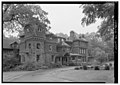 Dolobran (Clement A. Griscom mansion), Laurel Lane (1881), designed by Frank Furness
 -
 Merion Cricket Club, Montgomery Ave. & Grays Lane (1896), designed by Frank Furness


See also
- Haverford Township, Delaware County, Pennsylvania
- Haverford College
- The Haverford School
- Friends School Haverford
References
External links
Template:Sister project Template:Wikivoyage
Template:Lower Merion Template:Delaware County, Pennsylvania Template:Montgomery County, Pennsylvania Template:Authority control
- Pages using infobox settlement with the wikidata parameter
- Haverford Township, Pennsylvania
- Lower Merion Township, Pennsylvania
- Philadelphia Main Line
- Unincorporated communities in Delaware County, Pennsylvania
- Unincorporated communities in Montgomery County, Pennsylvania
- Unincorporated communities in Pennsylvania