Hurricane Gracie
Template:Short description Template:For Template:Infobox weather eventTemplate:Infobox weather event/NWSTemplate:Infobox weather event/EffectsTemplate:Infobox weather event/Footer
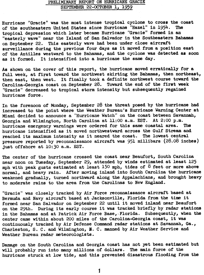
Hurricane Gracie was a powerful hurricane that formed in September 1959, the strongest during the 1959 Atlantic hurricane season and the most intense to strike the United States since Hurricane Hazel in 1954.<ref name="NHC1">National Hurricane Center. Preliminary Report on Hurricane Gracie: September 22-October 1, 1959. Template:Webarchive Retrieved on 2008-01-07.</ref> The system was first noted as an area of thunderstorms east of the Lesser Antilles which moved just north of the Greater Antilles, quickly intensifying into a hurricane on September 22. Gracie was a storm that was very difficult to forecast, with its movement unpredictable.<ref name="AH">Allan Huffman Hurricane Gracie. Template:Webarchive Retrieved on 2008-01-07.</ref> After five days of erratic motion, Gracie became a major hurricane which struck South Carolina, and weakened as it moved up the Appalachians, bringing much needed rain to a drought-plagued region. Much of the destruction related with Gracie was centered on Beaufort, South Carolina. Gracie became an extratropical cyclone on September 30 while moving through the Eastern United States.
Meteorological history
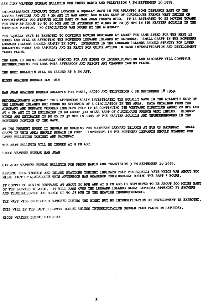
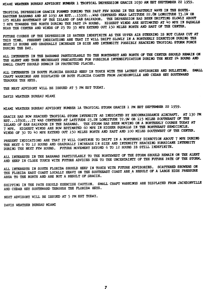
Template:Storm path An area of squally weather was first noted a few hundred miles east of the Lesser Antilles on September 18.<ref>National Hurricane Center. San Juan Weather Bureau Weather Bulletin for Press Radio and Television 3 PM September 18 1959. Template:Webarchive Retrieved on 2008-01-07.</ref> The convective area organized into a tropical depression near the north coast of Hispaniola on September 20. After moving west-northwestward for a day, it turned northeastward, where upper-level winds were very favorable and steering currents were very weak. On September 22 Gracie was named as a tropical depression before it developed into Tropical Storm Gracie,<ref>National Hurricane Center. Miami Weather Bureau Advisory Number 1 Tropical Depression Gracie 1030 AM EST September 22 1959. Template:Webarchive Retrieved on 2008-01-07.</ref> followed by reaching hurricane strength later that night. It turned to the east on September 25, and turned back west to west-northwest on September 27 as a stable anticyclone built in to its north.<ref name="AH"/><ref name="disc1">{{#invoke:citation/CS1|citation |CitationClass=web }}</ref>
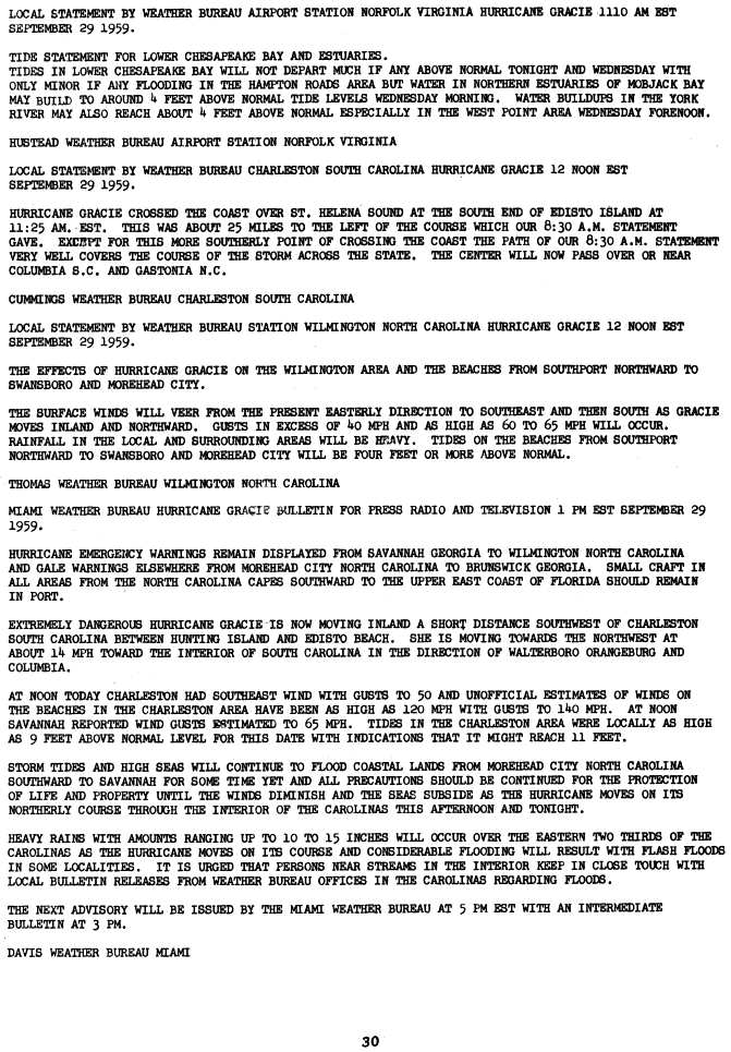
Gracie quickly strengthened and reached its peak of Template:Convert winds on September 29, but cooler air and land interaction weakened it slightly to a 130 mph (215 km/h) Category 4 major hurricane at the time of its landfall at 1625 UTC over St. Helena Sound near the south end of Edisto Island in South Carolina.<ref name="Reanalysis 1956-1960">{{#invoke:citation/CS1|citation |CitationClass=web }}</ref><ref>National Hurricane Center. Local Statement from Weather Bureau Charleston South Carolina Hurricane Gracie 12 Noon EST September 29 1959. Template:Webarchive Retrieved on 2008-01-07.</ref> After landfall, Gracie moved inland and north and became extratropical on September 30. Gracie's remnants persisted for several days as they slowly turned northeastward and then eastward. Gracie's remnants emerged into the Atlantic on October 2, before dissipating later that day.<ref name="hurdat">{{#invoke:citation/CS1|citation |CitationClass=web }}</ref>
Preparations
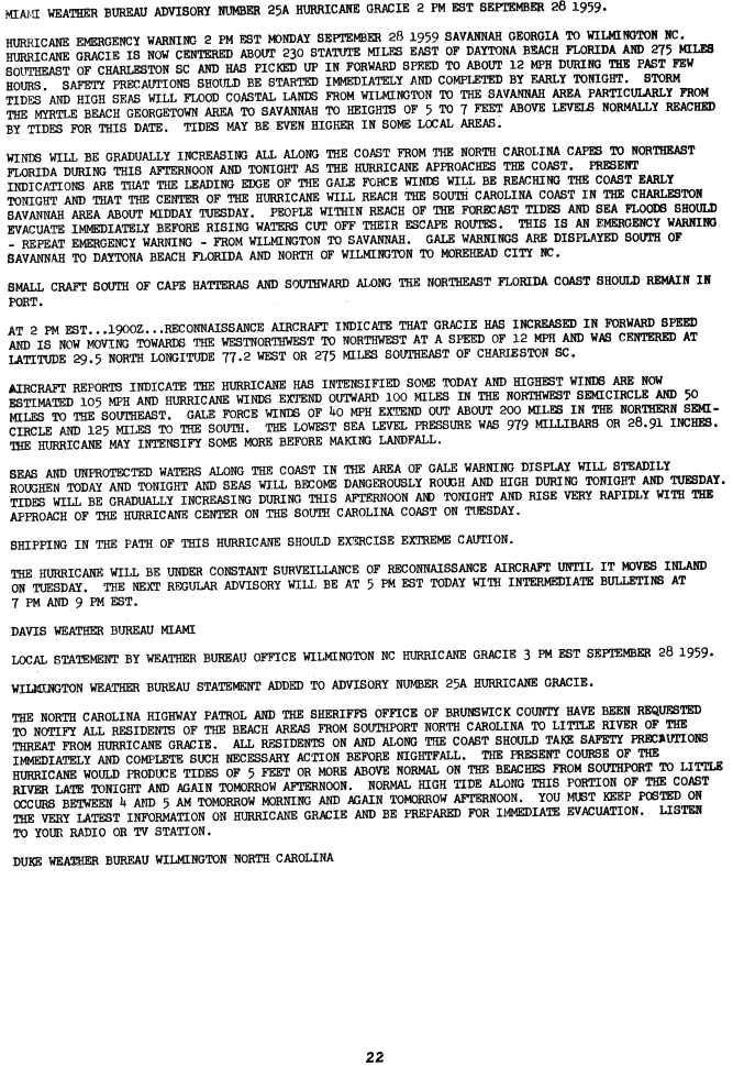
,_September_29,_1959.jpg)
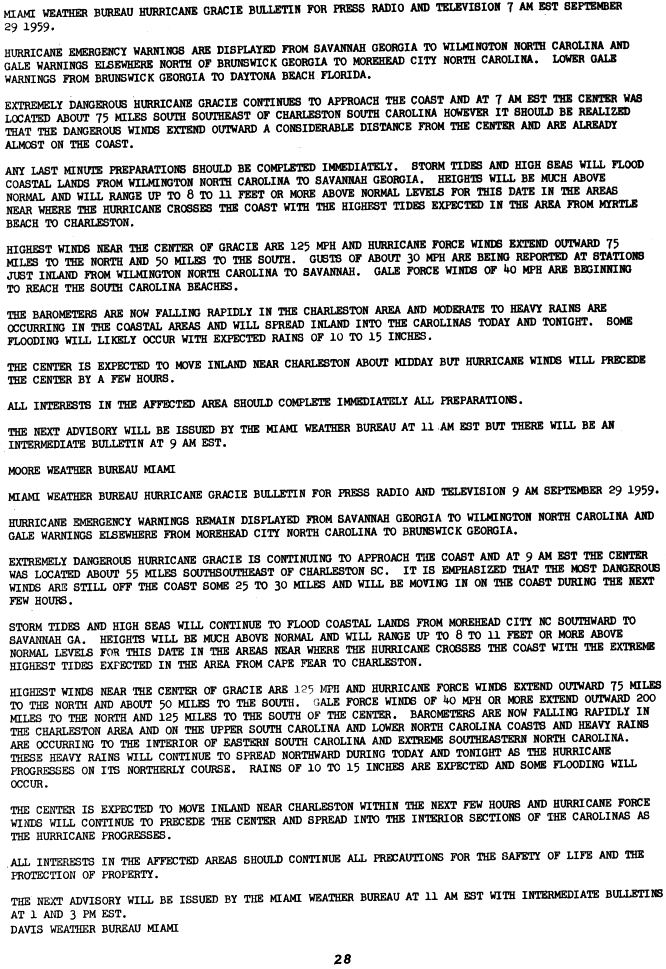
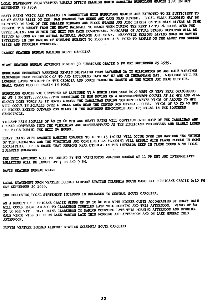
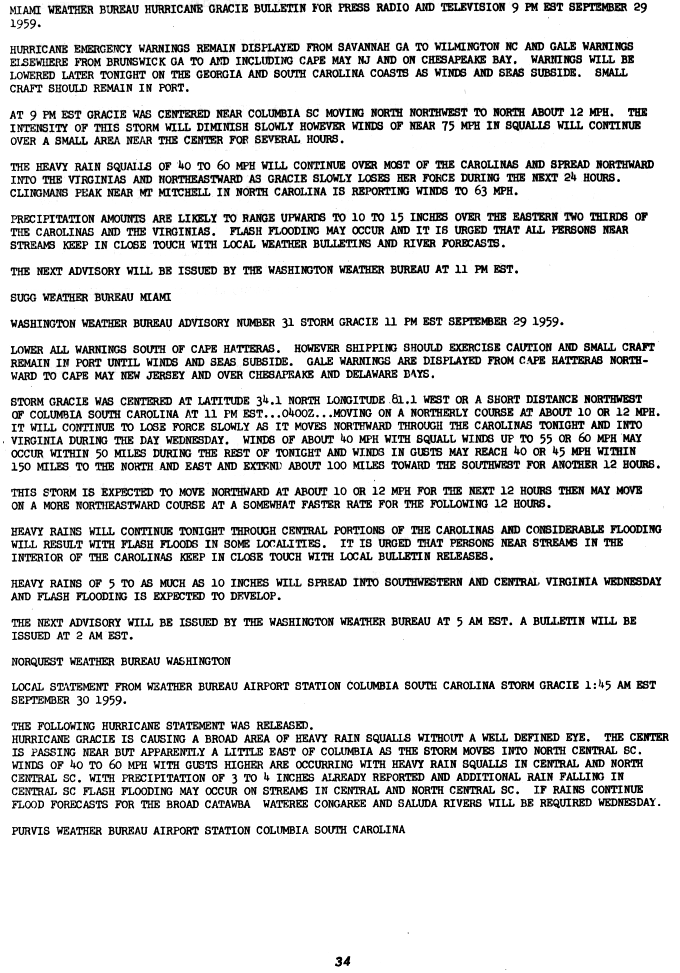
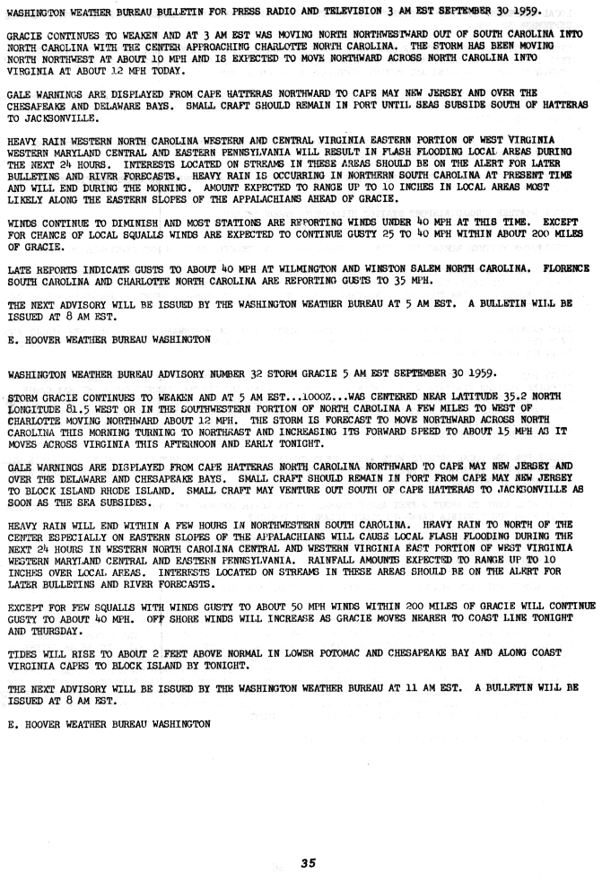
A hurricane watch was issued for the coast of the United States from Savannah, Georgia to Wilmington, North Carolina at 1600 UTC on September 28, which were quickly updated to hurricane warnings by 1900 UTC the same day.<ref name="NHC1"/> By 1900 UTC, gale warnings were in effect from Daytona Beach, Florida to Savannah, Georgia as well as from Wilmington to Morehead City, North Carolina.<ref>National Hurricane Center. Miami Weather Bureau Advisory Number 25A Hurricane Gracie 2 PM September 28 1959. Template:Webarchive Retrieved on 2008-01-07.</ref> At 1200 UTC on September 29, gale warnings were dropped south of Brunswick, Georgia.<ref>National Hurricane Center. Miami Weather Bureau Hurricane Gracie Bulletin For Press Radio and Television 7 AM September 29 1959. Template:Webarchive Retrieved on 2008-01-07.</ref> At 2200 UTC, gale warnings were extended northward to Cape May, New Jersey, including Chesapeake Bay and Delaware Bay.<ref>National Hurricane Center. Miami Weather Bureau Advisory Number 30 Hurricane Gracie 5 PM September 29 1959. Template:Webarchive Retrieved on 2008-01-07.</ref> At 0400 UTC on September 30, all warnings south of Cape Hatteras were dropped, leaving gale warnings in effect from Cape Hatteras northward.<ref>National Hurricane Center. Miami Weather Bureau Advisory Number 31 Hurricane Gracie 11 PM September 29 1959. Template:Webarchive Retrieved on 2008-01-07.</ref> At 1000 UTC, small craft were advised to remain in port from Cape May northward to Block Island, Rhode Island.<ref>National Hurricane Center. Washington Weather Bureau Advisory Number 32 Storm Gracie 5 AM September 30 1959. Template:Webarchive Retrieved on 2008-01-07.</ref> By 1600 UTC, due to Gracie's continued weakening, all remaining gale warnings were downgraded to small craft warnings.<ref>National Hurricane Center. Washington Weather Bureau Advisory Number 33 Storm Gracie 11 AM September 30 1959. Template:Webarchive Retrieved on 2008-01-07.</ref>
Impact
Georgia and South Carolina
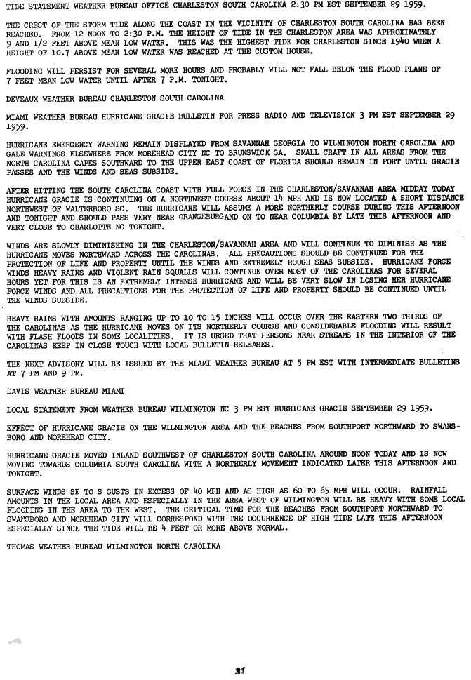
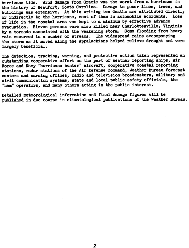
Storm surge flooding was minimal due to the storm's landfall near the time of low tide.<ref name="NHC1"/> However, Charleston still recorded their highest tide since 1940.<ref>National Hurricane Center. Tide Statement Weather Bureau Office Charleston South Carolina 2:30 PM EST September 29 1959. Template:Webarchive Retrieved on 2008-01-07.</ref> Along the coast of southern South Carolina, the storm tide was measured up to Template:Convert above mean lower low water (the average level of the lowest low tide each day).<ref>D. Lee Harris. U. S. Department of Commerce Weather Bureau Technical Paper No. 48: Characteristics of the Hurricane Storm Surge. Template:Webarchive Retrieved on 2008-01-12.</ref> The United States Coast Guard vessel Bramble evacuated people stranded in Savannah and Charleston on September 30.<ref>United States Coast Guard. Historical Context and Statement of Significance Cactus, Mesquite, and Basswood Classes United States Coast Guard 180-foot Buoy Tenders (WLBs). Template:Webarchive Retrieved on 2008-01-12.</ref> Gracie killed 10 people in South Carolina and Georgia, mainly due to wind and rain-induced automobile accidents, falling trees and electrocution by live wires. The Garden Club of South Carolina replaced numerous trees after the storm.<ref>South Carolina Department of Transportation. State Highway Map Features Garden Club o South Carolina. Template:Webarchive Retrieved on 2008-01-11.</ref> Wind damage was quite significant across South Carolina, particularly the city of Beaufort, South Carolina, with many downed trees, telephone poles, and streetlights. Also, numerous windows were shattered and shingles were torn off of roofs. A number of creeks overflowed causing floodwaters that, in areas, were several feet deep. The opening of the Beaufort Center of the University of South Carolina was delayed due to Gracie.<ref>University of South Carolina. USC Beaufort. Template:Webarchive Retrieved on 2008-01-11.</ref> It would be 30 years before another major hurricane struck South Carolina: Hurricane Hugo in September 1989.<ref name="hurdat"/>
Elsewhere in the United States
Heavy rains fell well ahead of the storm along an inverted trough extending north of the storm, causing Template:Convert between the mornings of September 28 and September 29 at Norfolk, Virginia.<ref>Daily Weather Maps. September 29, 1959. Template:Webarchive Retrieved on 2008-01-12.</ref> The highest rainfall amount measured during the storm was Template:Convert at Big Meadows.<ref>David M. Roth. Hurricane Gracie Rainfall Page. Template:Webarchive Retrieved on 2008-01-17.</ref> The storm spawned six tornadoes in all.<ref>{{#invoke:citation/CS1|citation |CitationClass=web }}</ref> This included three F3 tornadoes which accompanied the dissipating storm through Virginia, killing 12 people and injuring 13 near Charlottesville, Virginia. Three F1 tornadoes had touched down in the Carolinas prior to those touching down.<ref>Virginia Department of Emergency Management. Virginia's Weather History: Virginia Hurricanes. Template:Webarchive Retrieved on 2008-01-11.</ref> For the most part, rainfall from Gracie was beneficial as it moved up the Appalachians since the area had been in a drought preceding the cyclone.<ref name="NHC2">National Hurricane Center. Hurricane Gracie Preliminary Storm Report, page 2. Template:Webarchive Retrieved on 2008-01-07.</ref>
Long-term impact
Edisto Beach, South Carolina was changed forever by Gracie, due to human efforts to renourish the beach after its passage. Most of the shell hash beach currently at Edisto was placed there after Gracie. In order to expand the beach, an inland marsh was excavated and moved to the shoreline. This created highly desirable beach front property which led to new development along the coast seaward of Palmetto Boulevard, but also created an environmental catastrophe along the nearby ocean floor.<ref>Gered Lennon. Living With the South Carolina Coast. Template:Webarchive Retrieved on 2008-01-11.</ref> A species of isopod which grows in coastal estuaries, the Cyathura Polita, disappeared after the passage of this hurricane from the Ashepoo River in South Carolina.<ref>William D. Burbanck. The Disappearance of Cyathura Polita from the Ashepoo River, South Carolina, After Hurricane "Gracie" in 1959. Template:Webarchive Retrieved on 2008-01-11.</ref> The Kermadec petrel, a bird, was swept to Lookout Mountain Sanctuary in Pennsylvania during Gracie, marking the first time it appeared in North America.<ref>University of New Mexico. Kermadec Petrel in Pennsylvania. Template:Webarchive Retrieved on 2008-01-11.</ref>
See also
- List of Category 4 Atlantic hurricanes
- List of South Carolina hurricanes
- List of United States hurricanes
References
External links
Template:Category 4 Atlantic hurricanes Template:1959 Atlantic hurricane season buttons
ca:Plantilla:Huracans Atlàntics retirats simple:Template:Retired Atlantic hurricanes
- Pages with broken file links
- 1959 Atlantic hurricane season
- Category 4 Atlantic hurricanes
- Hurricanes in the Bahamas
- Hurricanes in South Carolina
- Hurricanes in Virginia
- 1959 in South Carolina
- 1959 in Tennessee
- 1959 in Virginia
- 1959 in the Bahamas
- Hurricanes in Tennessee
- 1959 in the Caribbean
- 1959 natural disasters in the United States