Kafr Jammal
Template:Pp-extended Template:Main other{{#invoke:Infobox|infobox}}Template:Template other{{#invoke:Check for unknown parameters|check|unknown=Template:Main other|preview = Page using [[Template:Template:If empty]] with unknown parameter "_VALUE_"|ignoreblank=y|mapframe_args=y | alt | anthem | anthem_link | area_blank1_acre | area_blank1_dunam | area_blank1_ha | area_blank1_km2 | area_blank1_sq_mi | area_blank1_title | area_blank2_acre | area_blank2_dunam | area_blank2_ha | area_blank2_km2 | area_blank2_sq_mi | area_blank2_title | area_code | area_code_type | area_codes | area_footnotes | area_land_acre | area_land_dunam | area_land_ha | area_land_km2 | area_land_sq_mi | area_metro_acre | area_metro_dunam | area_metro_footnotes | area_metro_ha | area_metro_km2 | area_metro_sq_mi | area_note | area_rank | area_rural_acre | area_rural_dunam | area_rural_footnotes | area_rural_ha | area_rural_km2 | area_rural_sq_mi | area_total_acre | area_total_dunam | area_total_ha | area_total_km2 | area_total_sq_mi | area_urban_acre | area_urban_dunam | area_urban_footnotes | area_urban_ha | area_urban_km2 | area_urban_sq_mi | area_water_acre | area_water_dunam | area_water_ha | area_water_km2 | area_water_percent | area_water_sq_mi | blank_emblem_alt | blank_emblem_link | blank_emblem_size | blank_emblem_type | blank_emblem_sizedefault | blank_emblem_upright | blank_info | blank_info_sec1 | blank_info_sec2 | blank_name | blank_name_sec1 | blank_name_sec2 | blank1_info | blank1_info_sec1 | blank1_info_sec2 | blank1_name | blank1_name_sec1 | blank1_name_sec2 | blank2_info | blank2_info_sec1 | blank2_info_sec2 | blank2_name | blank2_name_sec1 | blank2_name_sec2 | blank3_info | blank3_info_sec1 | blank3_info_sec2 | blank3_name | blank3_name_sec1 | blank3_name_sec2 | blank4_info | blank4_info_sec1 | blank4_info_sec2 | blank4_name | blank4_name_sec1 | blank4_name_sec2 | blank5_info | blank5_info_sec1 | blank5_info_sec2 | blank5_name | blank5_name_sec1 | blank5_name_sec2 | blank6_info | blank6_info_sec1 | blank6_info_sec2 | blank6_name | blank6_name_sec1 | blank6_name_sec2 | blank7_info | blank7_info_sec1 | blank7_info_sec2 | blank7_name | blank7_name_sec1 | blank7_name_sec2 | caption | code1_info | code1_name | code2_info | code2_name | coor_pinpoint | coor_type | coordinates | coordinates_footnotes | demographics_type1 | demographics_type2 | demographics1_footnotes | demographics1_info1 | demographics1_info10 | demographics1_info2 | demographics1_info3 | demographics1_info4 | demographics1_info5 | demographics1_info6 | demographics1_info7 | demographics1_info8 | demographics1_info9 | demographics1_title1 | demographics1_title10 | demographics1_title2 | demographics1_title3 | demographics1_title4 | demographics1_title5 | demographics1_title6 | demographics1_title7 | demographics1_title8 | demographics1_title9 | demographics2_footnotes | demographics2_info1 | demographics2_info10 | demographics2_info2 | demographics2_info3 | demographics2_info4 | demographics2_info5 | demographics2_info6 | demographics2_info7 | demographics2_info8 | demographics2_info9 | demographics2_title1 | demographics2_title10 | demographics2_title2 | demographics2_title3 | demographics2_title4 | demographics2_title5 | demographics2_title6 | demographics2_title7 | demographics2_title8 | demographics2_title9 | dimensions_footnotes | dunam_link | elevation_footnotes | elevation_ft | elevation_link | elevation_m | elevation_max_footnotes | elevation_max_ft | elevation_max_m | elevation_max_point | elevation_max_rank | elevation_min_footnotes | elevation_min_ft | elevation_min_m | elevation_min_point | elevation_min_rank | elevation_point | embed | established_date | established_date1 | established_date2 | established_date3 | established_date4 | established_date5 | established_date6 | established_date7 | established_title | established_title1 | established_title2 | established_title3 | established_title4 | established_title5 | established_title6 | established_title7 | etymology | extinct_date | extinct_title | flag_alt | flag_border | flag_link | flag_size | footnotes | founder | geocode | governing_body | government_footnotes | government_type | government_blank1_title | government_blank1 | government_blank2_title | government_blank2 | government_blank2_title | government_blank3 | government_blank3_title | government_blank3 | government_blank4_title | government_blank4 | government_blank5_title | government_blank5 | government_blank6_title | government_blank6 | grid_name | grid_position | image_alt | image_blank_emblem | image_caption | image_flag | image_map | image_map1 | image_seal | image_shield | image_size | image_skyline | imagesize | image_sizedefault | image_upright | iso_code | leader_name | leader_name1 | leader_name2 | leader_name3 | leader_name4 | leader_name5 | leader_party | leader_title | leader_title1 | leader_title2 | leader_title3 | leader_title4 | leader_title5 | length_km | length_mi | map_alt | map_alt1 | map_caption | map_caption1 | mapsize | mapsize1 | module | motto | motto_link | mottoes | name | named_for | native_name | native_name_lang | nickname | nickname_link | nicknames | official_name | other_name | p1 | p10 | p11 | p12 | p13 | p14 | p15 | p16 | p17 | p18 | p19 | p2 | p20 | p21 | p22 | p23 | p24 | p25 | p26 | p27 | p28 | p29 | p3 | p30 | p31 | p32 | p33 | p34 | p35 | p36 | p37 | p38 | p39 | p4 | p40 | p41 | p42 | p43 | p44 | p45 | p46 | p47 | p48 | p49 | p5 | p50 | p6 | p7 | p8 | p9 | parts | parts_style | parts_type | pop_est_as_of | pop_est_footnotes | population | population_as_of | population_blank1 | population_blank1_footnotes | population_blank1_title | population_blank2 | population_blank2_footnotes | population_blank2_title | population_demonym | population_demonyms | population_density_blank1_km2 | population_density_blank1_sq_mi | population_density_blank2_km2 | population_density_blank2_sq_mi | population_density_km2 | population_density_metro_km2 | population_density_metro_sq_mi | population_density_rank | population_density_rural_km2 | population_density_rural_sq_mi | population_density_sq_mi | population_density_urban_km2 | population_density_urban_sq_mi | population_est | population_footnotes | population_metro | population_metro_footnotes | population_note | population_rank | population_rural | population_rural_footnotes | population_total | population_urban | population_urban_footnotes | postal_code | postal_code_type | postal2_code | postal2_code_type | pushpin_image | pushpin_label | pushpin_label_position | pushpin_map | pushpin_map_alt | pushpin_map_caption | pushpin_map_caption_notsmall | pushpin_map_narrow | pushpin_mapsize | pushpin_outside | pushpin_overlay | pushpin_relief | registration_plate | registration_plate_type | seal_alt | seal_link | seal_size | seal_type | seat | seat_type | seat1 | seat1_type | seat2 | seat2_type | settlement_type | shield_alt | shield_link | shield_size | short_description | subdivision_name | subdivision_name1 | subdivision_name2 | subdivision_name3 | subdivision_name4 | subdivision_name5 | subdivision_name6 | subdivision_type | subdivision_type1 | subdivision_type2 | subdivision_type3 | subdivision_type4 | subdivision_type5 | subdivision_type6 | template_name | timezone | timezone_DST | timezone_link | timezone1 | timezone1_DST | timezone1_location | timezone2 | timezone2_DST | timezone2_location | timezone3 | timezone3_DST | timezone3_location | timezone4 | timezone4_DST | timezone4_location | timezone5 | timezone5_DST | timezone5_location | total_type | translit_lang1 | translit_lang1_info | translit_lang1_info1 | translit_lang1_info2 | translit_lang1_info3 | translit_lang1_info4 | translit_lang1_info5 | translit_lang1_info6 | translit_lang1_type | translit_lang1_type1 | translit_lang1_type2 | translit_lang1_type3 | translit_lang1_type4 | translit_lang1_type5 | translit_lang1_type6 | translit_lang2 | translit_lang2_info | translit_lang2_info1 | translit_lang2_info2 | translit_lang2_info3 | translit_lang2_info4 | translit_lang2_info5 | translit_lang2_info6 | translit_lang2_type | translit_lang2_type1 | translit_lang2_type2 | translit_lang2_type3 | translit_lang2_type4 | translit_lang2_type5 | translit_lang2_type6 | type | unit_pref | utc_offset | utc_offset_DST | utc_offset1 | utc_offset1_DST | utc_offset2 | utc_offset2_DST | utc_offset3 | utc_offset3_DST | utc_offset4 | utc_offset4_DST | utc_offset5 | utc_offset5_DST | website | width_km | width_mi }}{{#invoke:Check for clobbered parameters|check | template = [[Template:Template:If empty]] | cat = Template:Main other | population; population_total | image_size; imagesize | image_alt; alt | image_caption; caption | settlement_type; type | utc_offset1; utc_offset | timezone1; timezone }}{{#if:
|
}}Template:Main other{{#ifexpr:{{#invoke:ParameterCount|main|mapframe|image_map|image_map1|pushpin_map}} >2 |Template:Main other}}
Kafr Jammal (Template:Langx), is a Palestinian town in the Tulkarm Governorate in the western edge of the West Bank. It is located about halfway between Qalqilyah and Tulkarm, and had a population of 2,855 in 2017.<ref name="PrelimCensus2017" /> The village is mainly agricultural, and mostly raises olive and citrus crops. Kafr Jammal is at an altitude of 257 meters, and is bordered by Falamya (Falameh, Falāma) in the west, Kafr Zibad in the east, Jayyous in the south, and Kafr Sur to the north.
History
Ceramics from the Byzantine period have been found here.<ref>Dauphin, 1998, p. 772</ref>
Ottoman period
16th century
Kafr Jammal was incorporated into the Ottoman Empire in 1517 with all of Palestine, and in 1596 it appeared under that name in the tax registers as being in the Nahiya of Bani Sa'b, part of the Nablus Sanjak. It had a population of 17 households and 13 bachelors, all Muslims. The villagers paid a fixed tax rate of 33.3% on various agricultural products, such as wheat, barley, summer crops, olive trees, goats and/or beehives, in addition to "occasional revenues" and a press for olive oil or grape syrup; a total of 11,074 akçe.<ref name=Hutteroth140>Hütteroth and Abdulfattah, 1977, p. 140</ref>
19th century
In 1838, Kefr Jemmal was noted as a village in the Beni Sa'ab area, west of Nablus.<ref name=Robinsonp128>Robinson and Smith, 1841, vol 3, Appendix 2, p. 128</ref> In 1882, the PEF's Survey of Western Palestine described Kefr Jemmal as "a small stone village on a knoll, with cisterns."<ref>Conder and Kitchener, 1882, p. 165</ref>
In the 1860s, the Ottoman authorities granted the village an agricultural plot of land called Ghabat Kafr Jammal in the former confines of the Forest of Arsur (Ar. Al-Ghaba) in the coastal plain, west of the village.<ref>Marom, Roy, "The Contribution of Conder's Tent Work in Palestine for the Understanding of Shifting Geographical, Social and Legal Realities in the Sharon during the Late Ottoman Period", in Gurevich D. and Kidron, A. (eds.), Exploring the Holy Land: 150 Years of the Palestine Exploration Fund, Sheffield, UK, Equinox (2019), pp. 212-231</ref><ref>{{#invoke:citation/CS1|citation |CitationClass=web }}</ref>
In 1870/71 (1288 AH), an Ottoman census listed the village in the nahiya (sub-district) of Bani Sa'b.<ref>Template:Cite book</ref>
British Mandate
In the 1922 census of Palestine conducted by the British Mandate authorities, Kufr Jammal had a population of 396 Muslims,<ref name="Census1922">Barron, 1923, Table XI, Sub-district of Tulkarm, p. 28</ref> increasing in the 1931 census to 499; 1 Christian and 498 Muslims, in 109 houses.<ref name="Census1931">Mills, 1932, p.55</ref>
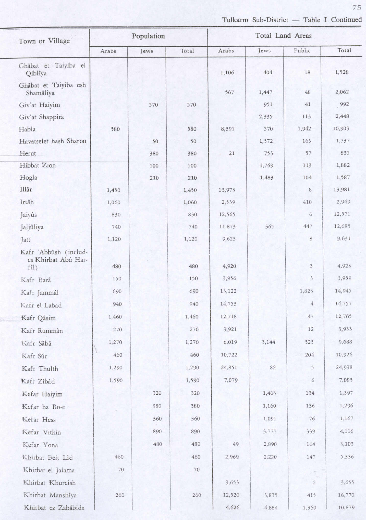
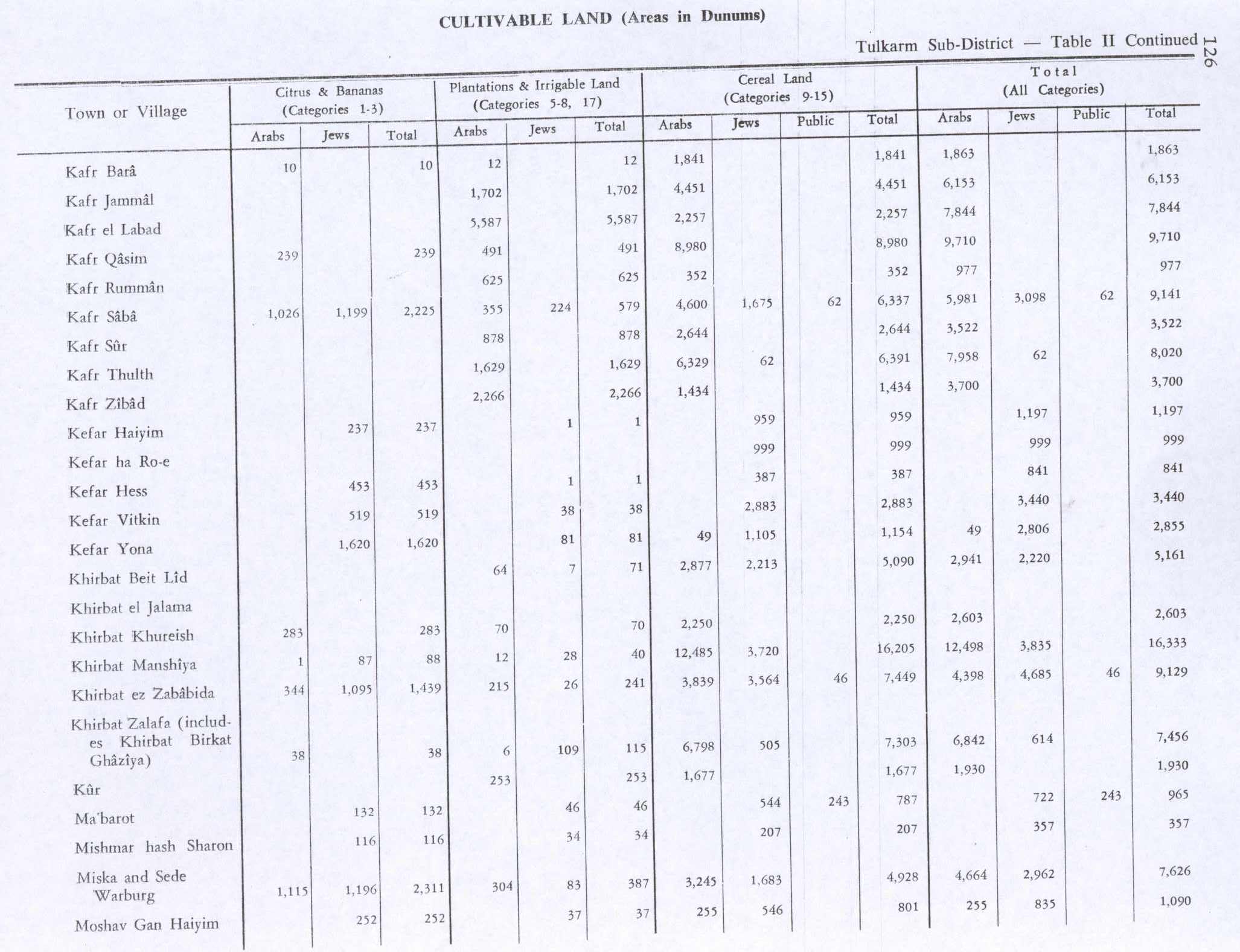
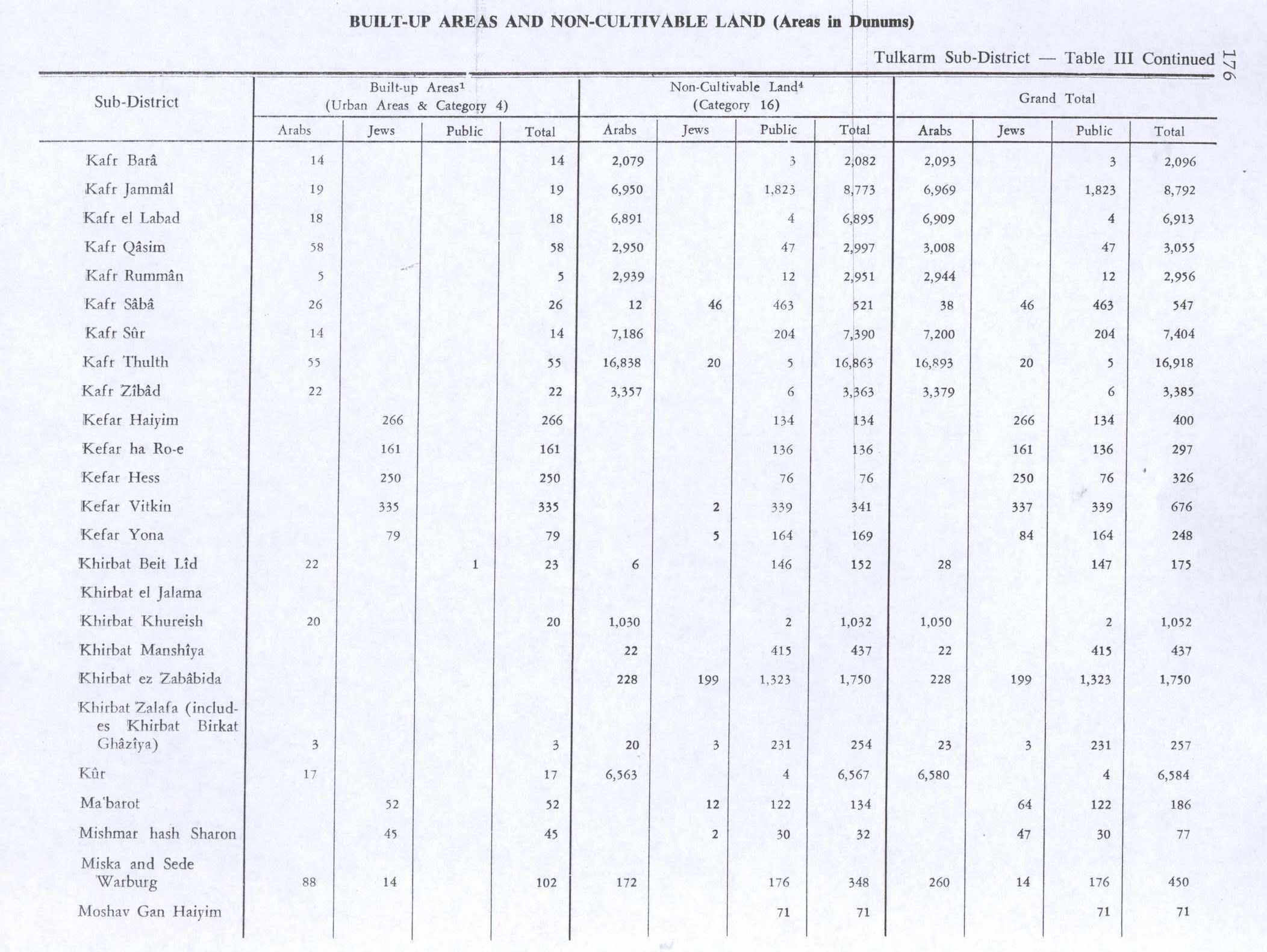
In the 1945 statistics the population of Kafr Jammal was of 690 Muslims,<ref name=DoS1945>Government of Palestine, Department of Statistics, 1945, p. 21</ref> with 14,945 dunams of land according to an official land and population survey.<ref>Government of Palestine, Department of Statistics. Village Statistics, April, 1945. Quoted in Hadawi, 1970, p. 75</ref> Of this, 1,702 dunams were plantations and irrigable land, 4,451 were used for cereals,<ref>Government of Palestine, Department of Statistics. Village Statistics, April, 1945. Quoted in Hadawi, 1970, p. 126</ref> while 19 dunams were built-up (urban) land.<ref>Government of Palestine, Department of Statistics. Village Statistics, April, 1945. Quoted in Hadawi, 1970, p. 176</ref>
-
 Falāma (west) and Kafr Jammal (east), 1942, 1:20,000
 -
 Falāma and Kafr Jammal (left, below Tulkarm), 1945, 1:250,000


Jordanian period (1948-1967)
In the wake of the 1948 Arab–Israeli War and after the 1949 Armistice Agreements, Kafr Jammal came under Jordanian rule.
In 1961, the population of Kafr Jamal was 1,041.<ref>Government of Jordan, Department of Statistics, 1964, p. 27</ref>
Post 1967
Since the Six-Day War in 1967, Kafr Jammal has been under Israeli occupation.
Kafr Jammal enjoys good relations with neighboring villages, and heavy education and commercial exchange take place among them. The village is also notable for having a large diaspora outside the West Bank, mostly in Jordan, but also in Saudi Arabia and the United States. Kafr Jammal's population follow the Hanbali and Shafi'i fiqh (schools of Sunni Islam).Template:Citation needed
Demography
Local origins
The residents of Kafr Jammal have origins in Kafr a-Dik.<ref>Grossman, D. (1986). "Oscillations in the Rural Settlement of Samaria and Judaea in the Ottoman Period". in Shomron studies. Dar, S., Safrai, S., (eds). Tel Aviv: Hakibbutz Hameuchad Publishing House. p. 346</ref>
Images
-
 Village center
 -
 Orange crop
 -
 Local cemetery


References
Bibliography
- Template:Cite book
- Template:Cite book
- Template:Cite book
- Template:Cite book
- Template:Cite book
- Template:Cite book
- Template:Cite book
- Template:Cite book
- Template:Cite book
- Template:Cite book
External links
- Welcome To Kafr Jammal
- Survey of Western Palestine, Map 11: IAA, Wikimedia commons
