Katla (volcano)
Template:Short description {{#invoke:other uses|otheruses}} Template:Use dmy dates Template:Infobox mountain Katla ({{#invoke:IPA|main}}) is an active subglacial volcano in southern Iceland. This volcano has been very active historically with at least twenty documented major eruptions since 2920 BC. In its recent history though, Katla has been less active as the last major eruption occurred in 1918. These eruptions have had a Volcanic Explosivity Index (VEI) of between 4 and 5 on a scale of 0 to 8. In comparison, the Eyjafjallajökull 2010 eruption had a VEI of 4. Larger VEI-5 eruptions are comparable to Mount St. Helens 1980 eruption. These eruptions have produced very large glacial outburst floods. Several smaller (minor) events measuring VEI-1 and below have occurred since.<ref name="2011 Remains dormant" />
Katla is one of the largest volcanic sources of carbon dioxide (CO2) on Earth, accounting for up to 4% of total global volcanic carbon dioxide emissions.<ref>Template:Cite journal</ref>
Geography and physical appearances
Katla is one of the largest volcanoes in Iceland.<ref name="Budd 2016 966–980">Template:Cite journal</ref> It is situated to the north of Vík í Mýrdal and to the east of the smaller glacier Eyjafjallajökull. Its peak reaches Template:Convert and is partially covered by the Mýrdalsjökull glacier. The system has an area of Template:Convert. The Eldgjá canyon is part of the same volcanic system,<ref name="gvp">Template:Cite gvp</ref><ref>Template:Cite journal</ref> and extends as a fissure swarm to the north-east. The lavas from this eruption in 939 to 940 almost reach the south eastern coast, although are partially buried.<ref name=Moreland2019>Template:Cite journal</ref>
The caldera of the Katla volcano has a diameter of Template:Convert and is covered with Template:Convert of ice. The volcano normally erupts every 40–80 years.<ref name="Budd 2016 966–980"/> The flood discharge at the peak of an eruption in 1755 has been estimated at 200,000–400,000 m3/s (7.1–14.1 million cu ft/sec), comparable to the combined average discharge of the Amazon, Mississippi, Nile, and Yangtze rivers (about 266,000 m3/s (9.4 million cu ft/sec)).
Etymology
The name Katla derives from the word ketill ("kettle"), referring to the form of the volcano. Katla is also used as a female first name.<ref>{{#invoke:citation/CS1|citation |CitationClass=web }}</ref>
Historic activity

There have been up to twenty three eruptions recorded for Katla since 920 CE.<ref name="CIV">{{#invoke:citation/CS1|citation |CitationClass=web }}</ref> Only two people are known to have died because of events directly associated with one of these eruptions in 1755.<ref name=Gísladóttir2021>Template:Cite journal</ref>Template:Rp The 1918 eruption of Katla started on the late afternoon of 12 October 1918 and lasted for 24 days, with the first day having the most dangerous events,<ref name=Gísladóttir2021/>Template:Rp<ref name="1918 eruption"/> including an extremely large flood with peak flow of Template:Cvt.<ref name=Larsen2021>Template:Cite journal</ref>Template:Rp It has been graded a VEI 4 level eruption.<ref name="History"/> The 1918 eruption resulted in extending the southern coast by Template:Cvt due to laharic flood deposits.<ref name=Larsen2021/>Template:Rp
Most of these eruptions resulted in glacial floods (jökulhlaups). Some Mýrdalsjökull jökulhlaups have been associated with catastrophic flooding which results from peak discharges of more than Template:Cvt,<ref>{{#invoke:citation/CS1|citation |CitationClass=web }}</ref> which is ten to a hundred times the size of most jökulhlaups.<ref name=McCluskey2019>Template:Cite thesis</ref> Apart from the 1755 and 1918 eruptions already mentioned in this regard, both of which like the majority of large floods drained onto the Mýrdalssandur plain to the volcanoes south-east, an eruption in 822 drained from the north-east aspect of the caldera down the Markarfljót river flood plain to the mountain's south-west covering an area of Template:Cvt.<ref name=Büntgen2017>Template:Cite journal</ref> This is a convoluted route that outputs on to a large flood plain, the Markarfljótsaurar.<ref name=McCluskey2019/> Before the Hringvegur (Iceland's Ring Road) was constructed in 1974, people feared traversing the plains in front of the volcano because of the frequent jökulhlaup (or glacier bursts) and the deep river crossings.
Recent activity

Katla has been showing signs of unrest since 1999, and geologists have concerns that it might erupt in the near future.<ref name=uofi2>{{#invoke:citation/CS1|citation |CitationClass=web }}</ref> The volcano's present dormancy is among the longest in its known history.<ref>{{#invoke:citation/CS1|citation |CitationClass=web }}</ref> Particularly, monitoring has been intensified following the March 2010 eruptions of a smaller neighbouring volcano, the Eyjafjallajökull glacier.<ref>Template:Cite news</ref> The eruption of this nearby long-dormant volcano in March and April 2010 prompted fears among some geophysicists that it might trigger an eruption at the larger and more dangerous Katla.<ref>Volcano erupts in south Iceland BBC online news. Retrieved 21 March 2010.</ref><ref name="times-7070239">Template:Cite news</ref><ref>Template:Cite news</ref> In the past 1,000 years, all three known eruptions of Eyjafjallajökull have triggered subsequent Katla eruptions.<ref name="times-7070239"/>
Following the 2010 Eyjafjallajökull eruptions, on 20 April 2010 Icelandic President Ólafur Grímsson said "the time for Katla to erupt is coming close ... we [Iceland] have prepared ... it is high time for European governments and airline authorities all over Europe and the world to start planning for the eventual Katla eruption".<ref>Template:Cite news</ref>
Increased earthquake activity had been noticed on Katla since the eruption at Eyjafjallajökull, but no other signs of an imminent eruption were observed. These quakes are located mainly on the northwestern rim of the caldera. On 9 October 2010, a sudden rise in harmonic tremor was observed in the stations around Katla, but although a sign of a possible impending eruption,<ref>{{#invoke:citation/CS1|citation |CitationClass=web }}</ref> none occurred.
2011 activity
In 2011, geologic activity led many to speculate that a very small subglacial eruption had taken place.<ref name="2011 Remains dormant" /> In June 2011, harmonic tremor was again detected at Katla volcano. A few days later, an earthquake swarm took place in the caldera, indicating magma movement inside the volcano, leading to increased fears of an eruption in the near future.<ref>{{#invoke:citation/CS1|citation |CitationClass=web }}</ref>
On 8 and 9 July 2011, another spike in harmonic tremors occurred, as a small eruption of Katla took place. Cracks formed on the glacier, as well as a cauldron.<ref>{{#invoke:citation/CS1|citation |CitationClass=web }}</ref> Icelandic media reported a small subglacial eruption might have started.<ref>Template:Cite news</ref> On the morning of 9 July 2011, a glacier flood was reported in the river Múlakvísl, and also later in the river Skálm. The bridge across Múlakvísl was destroyed as well as other parts of the road, Route 1, on the Icelandic ring road. Helicopter pilots flying over the glacier also reported cracks in the glacier.<ref>Template:Cite news</ref> Scientists monitoring the activity said speculation that it was caused by a "very small" subglacial eruption lacked confirmation by visual or seismic evidence.<ref name="2011 Remains dormant">{{#invoke:citation/CS1|citation |CitationClass=web }}</ref>
2016 and 2017 activity
Tremors were detected under Katla in late August 2016.<ref name="specialist">{{#invoke:citation/CS1|citation |CitationClass=web }}</ref><ref>{{#invoke:citation/CS1|citation |CitationClass=web }}</ref>
A "Specialist Description" describing the activity on 29 August 2016 noted that there was:
... a seismic swarm in Mýrdalsjökull on the 29th of August with two events in the northern Katla caldera rim measured at magnitude 4.5. These are the biggest earthquakes in Katla volcano since 1977. Earthquake eruption checks confirmed that most earthquakes occurred between 0:40 and 1:50 PM. The big earthquakes were about thirty seconds apart at 1:47. They were followed by more than 50 aftershocks until 15:12 PM, when there was an earthquake of magnitude 3.3 and then the cycle and seismic activity in the region reduced again. No unrest was measured along these earthquakes. The geothermal has decreased in the following week and is now negligible.<ref>{{#invoke:citation/CS1|citation
|CitationClass=web
}}</ref>
An update written at 11 Sep 16:38 GMT reported:
Today, shortly before 14:00, a small earthquake swarm began in Mýrdalsjökull. The largest earthquakes of the swarm were of magnitude 3.3 and 3.0 at 16:12 and 15:57. More than 10 smaller earthquakes were detected in the swarm. All of the earthquakes were shallow and located in the caldera of Katla volcano. It is not unusual for seismic swarms of this type to occur in this area.<ref>{{#invoke:citation/CS1|citation
|CitationClass=web
}}</ref>
In February 2017, seismic activity at the volcano continued.<ref>{{#invoke:citation/CS1|citation |CitationClass=web }}</ref>
| Start Date<ref name="History"/> | End Date<ref name="History"/> | VEI<ref name="History"/> | Scale | Tephra volume (km3)<ref name="History"/> |
Comment |
|---|---|---|---|---|---|
| Template:Dts<ref name="CIV"/> | Template:Dts<ref name="CIV"/> | Template:Unknown | Template:Unknown | This eruptions details are uncertain, with unclear end time, but a jökulhlaup occurred that damaged a bridge.<ref name="CIV"/> | |
| Template:Dts | Template:Dts | 0 | Minor | Template:Unknown | This eruption is uncertain, and could have been subglacial. A jökulhlaup occurred. |
| Template:Dts | Template:Unknown | 0 | Minor | Template:Unknown | This eruption is uncertain, and could have been subglacial. A jökulhlaup occurred. |
| Template:Dts | Template:Dts | 4 | Major | 0.7 | Last major eruption of Katla. A jökulhlaup occurred. |
| Template:Dts | Template:Dts | 4 | Major | 0.2 | Dated using historical records. A jökulhlaup occurred. |
| Template:Dts | Template:Dts | 3 | Minor | 0.1 | This eruption was dated using historical records. The eruption "VEI" is speculated. A jökulhlaup occurred. |
| Template:Dts | Template:Dts | 5 | Major | 1.5 | This eruption was dated using historical records. The eruption "VEI" is speculated. A jökulhlaup occurred. The two people who died were struck by lightning.<ref name=Gísladóttir2021/>Template:Rp |
| Template:Dts | Template:DtsTemplate:Efn | 5 | Major | 1.2 | This eruption was dated using historical records. The eruption "VEI" is speculated. A jökulhlaup occurred. |
| Template:Dts | Template:Dts | 4 | Major | 0.2 | Dated using historical records. A jökulhlaup occurred. |
| Template:Dts | Template:Dts | 5 | Major | 1.5 | Dated using historical records. A jökulhlaup occurred. |
| Template:Dts | Template:Unknown | 4 | Major | 0.2 | Dated using historical records. A jökulhlaup occurred. |
| Template:Dts | Template:Unknown | 4 | Major | 0.2 | Dated using historical records. |
| Template:Dts | Template:Unknown | 4 | Major | 0.2 | The estimated date is based on tephrochronology. |
| Template:Dts | Template:Unknown | 4 | Major | 0.2 | The estimated date is based on tephrochronology. |
| Template:Dts | Template:Unknown | 4 | Major | 0.2 | Dated using historical records. |
| Template:Dts | Template:Unknown | 4 | Major | 0.2 | While this eruption is dated using historical records, the VEI and tephra volume amounts are speculated. |
| Template:DtsTemplate:Efn | Template:Unknown | 4 | Major | 0.7 | Dated using historical records. |
| Template:Dts | Template:Unknown | 5 | Major | 1.5 | Dated using historical records. |
| Template:Dts | Template:Unknown | 4 | Major | 0.2 | Dated using historical records. |
| Template:Dts | Template:Unknown | 4 | Major | 0.1 | The estimated date is based on tephrochronology. |
| Template:Dts | Template:Unknown | 3 | Minor | 0.01 | Dated using historical records. |
| Template:Dts | Template:Unknown | 3 | Minor | 0.05 | The estimated date is based on tephrochronology. |
| Template:Dts<ref name=Moreland2019/> | Template:Dts<ref name=Moreland2019/> | 4 | Major | 5.0 | The Eldgjá eruption estimated VEI is based on an ice core. Dated using historical records, ice core and tephrochronology |
| Template:Dts | Template:Unknown | 4 | Major | 0.2 | Dated using historical records. |
| Template:DtsTemplate:Efn | Template:Dts | - | Major | small | large sulfate, likely effusive and earliest accurately dated Katla eruption (possibly AT-4) and jökulhlaup to late 822 to early 823 by tree ring data.<ref name=Büntgen2017/><ref name =Gabriel2024 >Template:Cite journal</ref>Template:Efn |
| Template:DtsTemplate:Efn | Template:DtsTemplate:Efn | - | Major | 4.5 | Multiple eruptions with both sulfate and tephra peaks in Greenland core (Hrafnkatla, AT-8 or E2). Largest eruptions were 757 and 763.<ref name =Gabriel2024 /> May include K1220 and K1270 from Torfdalsvatn alkali basalt tephras which include 5 events.<ref name=Harning2024>Template:Cite journal</ref>Template:Efn |
| Template:DtsTemplate:Efn | Template:Unknown | 3 | Minor | 0.085 | Based on radiocarbon dating. |
| Template:Dts BCTemplate:Efn | Template:Unknown | 4 | Major | 0.29 | Based on radiocarbon dating. |
| Template:Dts BCTemplate:Efn | Template:Unknown | 3 | Minor | 0.065 | Based on radiocarbon dating. |
| Template:Dts BCTemplate:Efn | Template:Unknown | 4 | Major | 0.22 | Based on radiocarbon dating. |
| Template:Dts BC | Template:Unknown | 4 | Major | 0.13 | Based on radiocarbon dating. |
| Template:Dts BC | Template:Unknown | 3 | Minor | 0.075 | The estimated date is based on tephrochronology. |
| Template:Dts BCTemplate:Efn | Template:Unknown | Template:Unknown | - | Template:Unknown | Alkali basalt tephra, the date is based on tephrochronology.<ref name=Harning2024/> |
| Template:Dts BCTemplate:Efn | Template:Unknown | Template:Unknown | - | Template:Unknown | Rhyolite tephra in 3 events, the date is based on tephrochronology.<ref name=Harning2024/> |
| Template:Dts BCTemplate:Efn | Template:Unknown | Template:Unknown | - | Template:Unknown | Rhyolite tephra, the date is based on tephrochronology.<ref name=Harning2024/> |
| Template:Dts BCTemplate:Efn | Template:Unknown | Template:Unknown | - | Template:Unknown | Rhyolite tephra, the date is based on tephrochronology.<ref name=Harning2024/> |
Other activity
Template:OSM Location map As well as eruptions Katla is host to geothermal systems and these contribute to many of the smaller jökulhlaups from the mountain. Jökulhlaup triggering at Mýrdalsjökull may result from geothermal processes, and ice dams and their sudden removal by floating of the ice above a lake of melt water. Some eruptions could be secondary to the removal of overpressure by a jökulhlaup.<ref name=Björnsson2003>Template:Cite journal</ref> There are currently at least 20 ice cauldrons known related to the geothermal areas within the caldera.<ref name =IWOJuly2024 /> These are often manifest as depressions in the ice cap rather than full thickness to the underlying rock cauldrons and have variable activity.<ref name="MTG1">Template:Cite journal</ref>Template:Rp Geothermal waters with a high volcanic mineral and gas content are produced and can result in both gas and water pollution.<ref name=hi>{{#invoke:citation/CS1|citation |CitationClass=web }}</ref>
Risks
The area of the volcano contributes to the most serious natural hazard area of Iceland.<ref name=Sigurðsson2010>Template:Cite journal</ref> The most likely large eruption had in 2019 a 89% probability of occurring within 30 years and would likely be associated with tephra production of about Template:Cvt which can be compared with the Template:Cvt that disrupted air travel from the second phase of the 2010 eruptions of Eyjafjallajökull.<ref name=McCluskey2019/>Template:Rp<ref>Erica R. Hendry "What We Know From the Icelandic Volcano Template:Webarchive," Smithsonian, 22 April 2010. Retrieved April 2010.</ref> It is most likely to occur in the months June to September, and be associated with a jökulhlaup flowing from Kotlujökull an outlet glacier to the south-east, over Mýrdalssandur to the sea where it could affect the town of Vík í Mýrdal.<ref name=McCluskey2019/>Template:Rp The 1755 and 1918 eruptions show that lightning and tephra fall are perceived as dangerous by humans in the immediate vicinity of a large eruption and have influenced jökulhlaup evacuation planning.<ref name=Gísladóttir2021/>Template:Rp Geothermal jökulhlaups can be large enough to damage property and infrastructure.<ref name=Björnsson2003 />
Monitoring
Because of such risks the volcano is intensively monitored. The Icelandic Meteorological Office updates its website with reports of quakes both at Eyjafjallajökull and Katla.<ref name="en.vedur.is">{{#invoke:citation/CS1|citation |CitationClass=web }}</ref> Continuous monitoring includes for seismic flood tremor, water gauges and water conductivity given the flood risk.<ref name=imo2011>{{#invoke:citation/CS1|citation |CitationClass=web }}</ref> The ice cauldrons of Mýrdalsjökull are also monitored.<ref name=hi/>
Folklore
{{#invoke:Hatnote|hatnote}} In folklore, the witch named Katla is held responsible for causing the jökulhlaup (outburst) of the Mýrdalsjökull glacier over the volcano; these events are dubbed {{#invoke:Lang|lang}} (or "Katla's eruption"<ref name="thordarson&hoskuldsson2014"/>).Template:Sfnp The folktale recorded by Jón Árnason in 1862<ref name="jon_arnason1862">Template:Cite wikisource </ref> probably dates much older since it is set in the time of the Template:Illm, the Catholic monastery abolished c. 1550.Template:Sfnp
The short folktale entitled "Katla eða Kötlugjá" can be summarized as follows: In the pre-Reformation days when the Þykkvibær monastery was installed with an abbot, they had a cranky housekeeper there named Katla, well versed in (ancient) magic ({{#invoke:Lang|lang}}), instilling fear in others.Template:Sfnp She owned a magical pair of breeches ({{#invoke:Lang|lang}}, 'trousers'), which allowed its wearer to run endlessly without fatigue, but herself reserved its use for an emergency. One day in autumn, the abbot's shepherd Barði has trouble rounding up the sheep before master and the housekeep return from a banquet, and he borrows the breeches to retrieve the stray. Katla discovers the transgression and ambushes him, drowning him in a vat of sour whey ({{#invoke:Lang|lang}}).Template:Refn But as winter wore on, the whey began to dwindle and Katla was heard muttering "Barði will soon appear".<ref>After Template:Harvp "Barði will soon appear". Cf. Zoëga (1922) Icelandic-English dictionary s.v. "{{#invoke:URL|url}}{{#invoke:Check for unknown parameters|check|unknown=Template:Main other|preview=Page using Template:URL with unknown parameter "_VALUE_"|ignoreblank=y | 1 | 2 }}" : impers. bryddir á e-u something begins to appear </ref> Realizing the discovery of her crime and punishment was imminent, she put on her breeches and disappeared to the northwest, presumably diving straight into the glacier. Right afterwards a glacial outburst (jökulhlaup) occurred that rushed towards the monastery and Template:Illm.<ref name="jon_arnason1862"/>Template:Sfnp
Other geologic features such as {{#invoke:Lang|lang}} ('Katla's gorge') and the surrounding area made desolate, named {{#invoke:Lang|lang}} also bear names alluding to the Katla folklore.Template:Sfnp
Images
-
 The Mýrdalsjökull glacier in 2005
 -
 The Mýrdalsjökull glacier in 2005
 -
 Katla from the Myrdalssandur flood plain in 2008
 -
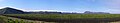
 Katla in 2017
 -
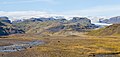
 wider view of Katla in 2017


In popular culture
Katla is the subject of Katla, an Icelandic TV series produced for Netflix.
See also
- Glacial lake outburst flood
- Ice cauldron
- Iceland hotspot
- Iceland plume
- List of glaciers of Iceland
- Volcanism of Iceland
Notes
References
- Citations
- Bibliography
External links
Template:Commonscatinline Template:Refbegin
- Katla in the "Catalogue of Icelandic Volcanoes"]
- Volcanism 1 Template:Webarchive
- University of Iceland's Institute of Earth Sciences page about Katla
- Webcams from Iceland, including Katla
- Katla: preparedness for tourists
- Icelandic Meteorological Office: Katla status
- Constantly updating map of earthquakes in Mýrdalsjökull
- {{#invoke:citation/CS1|citation
|CitationClass=web }} (with narration audio [mp3 format]) Template:Refend