Kure Atoll
Template:Short description Template:Infobox islands
Kure Atoll (Template:IPAc-en; Template:Langx; Template:Langx)<ref>{{#invoke:citation/CS1|citation |CitationClass=web }}</ref> or Ocean Island is an atoll in the Pacific Ocean Template:Convert west-northwest of Midway Atoll in the Northwestern Hawaiian Islands at Template:Coord. A coral ring Template:Convert across encloses a lagoon several meters deep. The atoll's largest island is called Green Island, and is a habitat for hundreds of thousands of seabirds in the present day and wildlife staff. A short, unused, and unmaintained runway and a portion of one building, both from a former United States Coast Guard LORAN station, are located on the island. Politically, it is part of Hawaii, though the nearest island is Midway, which is a separate unorganized territory. Kure Atoll, in addition to being the nesting grounds for tens of thousands of seabirds, has recorded several vagrant terrestrial birds, including snow bunting, eyebrowed thrush, brambling, olive-backed pipit, black kite, Steller's sea eagle and Chinese sparrowhawk. It is currently managed as a Wildlife Bird Sanctuary by the State of Hawaii's Department of Land and Natural Resource—Division of Forestry and Wildlife as one of the co-trustees of Papahānaumokuākea Marine National Monument with support from the Kure Atoll Conservancy. Kure is one of the westernmost islands of the Northwestern Hawaiian Islands.
Kure is seasonally inhabited by small crews of two to eight volunteers and biologists who work to restore and manage the native ecosystem.
Kure was discovered in the early 19th century and was the site of several shipwrecks. In the early 20th century it became a bird nature reserve of the United States. In the late 20th century, it was home to a radio base that supported location finding (LORAN system before GPS), and in the 21st century it is mostly a nature reserve and for scientific research. Kure, or sometimes written Cure, used to be called Ocean Island up until 1924 when it was renamed; in 1987 this changed to Kure Atoll (atoll rather than island). There are also several native Hawaiian names; some depend on context. Moku Papapa is the generic name for a flat island like this atoll but became more associated with it, and another one is Hōlanikū.
There are no more islands to the west until Japan. Though historically it was thought there might be, none were confirmed (see phantom islands such as the Byer's/Morrell's islands and the Anson Archipelago). To the west and south, across a great amount of ocean, are the Bonin and Volcano Islands (such as Iwo Jima); to the southwest are Minamitorishima and Wake Island. The Aleutian island chain that extends out from Alaska lies far to the north. The nearest feature to the west, but below sea level, is Hancock Seamount. The submerged Hawaiian–Emperor seamount chain continues to the northwest. Kure is the farthest west and north island of the Hawaiian chain above sea level in the present day. Other underwater features in the region include the Mid-Pacific Mountains to the south, and to the north, the Hess rise (underwater features).
Hess bank to the north has the historical undersea feature the Mellish bank.<ref>{{#invoke:citation/CS1|citation |CitationClass=web }}</ref>
History
The island was discovered in the early 19th century, and besides from shipwrecks was only occasionally visited. From the 1960s to 1992, it had LORAN radio station, which had a small staff and an airstrip. It has been a nature reserve since that time, and marine debris cleanup and scientific research on the nature is conducted.
In the Hawaiian language the term {{#invoke:Lang|lang}} was used for any flat island with reefs.<ref>Template:Hawaiian Dictionaries</ref> The northwestern islands are associated with Kāne Milohaʻi in Hawaiian mythology, the brother of Pele, creator of the islands, who was left to stand guard for travelers.<ref>Template:Hawaiian Dictionaries</ref> Another Hawaiian name for Kure Atoll is {{#invoke:Lang|lang}}, meaning "bringing forth heaven."<ref>{{#invoke:citation/CS1|citation |CitationClass=web }}</ref>
19th century
Before the mid-19th century, Kure Atoll was visited by several ships and given new names each time. Sometimes spelled Cure, its English name was for a Russian navigator who sighted the atoll.<ref>Template:Hawaiian Dictionaries</ref> It was officially named Kure Island in 1924 and then Kure Atoll in 1987.<ref>Template:GNIS</ref> The old name for the island was Ocean Island.<ref name=":3">Template:Cite book</ref>
Two shipwrecks in the early 19th century were the Gledstanes and the Parker, in 1837 and 1842 respectively.<ref name=":4">{{#invoke:citation/CS1|citation |CitationClass=web }}</ref> The Gledstanes crewmembers were able to make it to the island and then were able to build a new vessel from the debris of their old ship. Some of the survivors then sailed it back to mainland Hawaii.<ref name=":5">{{#invoke:citation/CS1|citation |CitationClass=web }}</ref> Once they reached Hawaii, they sent a ship back to rescue those who had stayed behind on the island.<ref name=":3" /> The shipwreck of the Gledstanes was found in 2008.<ref name=":5" />
The ParkerTemplate:'s crew had a somewhat more difficult time but did manage to get to land by floating on a raft for several days.<ref name=":4" /> They managed to survive on a diet of birds and other wildlife at the atoll, living on what is now Green island.<ref name=":4" /> They even encountered the dog from the Gledstanes who had been living wild on the island in the previous years.<ref name=":4" /> They attempted to make contact with the outside world by attaching messages to seabirds.<ref name=":4" /> The Parker had shipwrecked in September 1842 and having lived at Kure Atoll, many of the crew were finally rescued on April 16, 1843, with the remainder taken off on May 2, 1843.<ref name=":4" /> The first rescue ship was the James Stewart and the second rescue ship was the whaler Nassau.<ref name=":4" />
Many crews were stranded on Kure Atoll after being shipwrecked on the surrounding reefs and had to survive on the local seals, turtles, and birds. The shipwrecks remain on the reef today, including the Template:USS. Because of these incidents, King Kalākaua sent Colonel J. H. Boyd to Kure as his Special Commissioner. On September 20, 1886, he took possession of the island for the Hawaiian government. The King ordered that a crude house be built on the island, with tanks for holding water and provisions for any other unfortunates who might be cast away there. However, the provisions were stolen within a year and the house soon fell into ruin.<ref name=":0" />
In 1867, the USS Lackawanna surveyed the atoll to produce more accurate charts of the reefs.<ref name=":0" />
The USS Saginaw wrecked on the atoll in October 1870. The crew was able to abandon ship, but not much was saved. A crew of five sailed the captain's gig to the island of Kauai, but only one survived the difficult month-long voyage. Despite this, word did get to the authorities, who sent a rescue ship to the stranded crew which was able to rescue them in January 1871.<ref name=":3" />
The vessel Dunnottar Castle shipwrecked in 1886, and the crew was able to reach Kauai eventually; however, some lives were lost.<ref name=":3" />
20th century
Largely neglected for most of its history, during World War II Kure was routinely visited by U.S. Navy patrols from nearby Midway to ensure that the Japanese were not using it to refuel submarines or flying boats from submarine-tankers for attacks elsewhere in the Hawaiian chain. During the Battle of Midway, a Japanese Nakajima B5N "Kate" bomber, operating from aircraft carrier Hiryū, piloted by Lieutenant Kikuchi Rokurō, and which had been involved in the initial Japanese attack on Midway's US installations, crash-landed near Kure after being damaged by US fighters.<ref name="sword">Template:Cite book</ref> Once ashore, Lt. Kikuchi and the two other members of his crew (Warrant Officer Yumoto Noriyoshi and Petty Officer (1st Class) Narasaki Hironori) refused capture and were either killed or committed suicide when an American landing party tried to capture them.<ref name="sword"/>
In the 1950s, there was a radar reflector on the island, and the island was also used for a scientific study of Pacific birds.<ref name=":1" /> In 1959 zig-zag stripes were cut through the groves of Scaevola bushes to make habitat space for albatrosses.<ref>Template:Cite journal</ref>
In 1960, construction began on a LORAN base and it was finished in 1961.<ref name=":2">Honolulu January 1986 At the End of the Chain by Brian Nicol</ref> Also in 1961, the tug Port of Bandon sank on the reef.<ref name=":2" /> The base included buildings for the LORAN station, a Template:Convert LORAN radio tower, and a Template:Convert airstrip.<ref>KURE-ATOLL-DARK-SIDE-OF-THE-SUN 2001</ref><ref name=":0" />
Between 1963 and 1965, the Polynesian rat (Rattus exulans) population was studied.<ref>Template:Cite journal</ref>
In 1966, a Boeing 707 jet airliner made an emergency landing at Kure Atoll.<ref name=":7">{{#invoke:citation/CS1|citation |CitationClass=web }}</ref>
Kure is located within a major current which washes up debris from the Great Pacific Garbage Patch, such as fishing nets and large numbers of cigarette lighters, on the island. These pose threats to the local animals, especially birds, whose skeletons are frequently found with plastic in the stomach cavity.<ref name=Safina/><ref>Papahānaumokuākea Marine National Monument Kure Atoll Template:Webarchive</ref>
On October 16, 1998, the longline fishing vessel Paradise Queen II ran aground on the eastern edge of Green Island of Kure Atoll, spilling approximately 4,000 gallons of diesel fuel before recovery operations could commence. Debris from that shipwreck continued to pollute the reef and shoreline for many years, endangering wildlife and damaging the coral reef. The long-term impact of this and other wrecks within the Northwestern Hawaiian Islands (NWHI) highlight the dangers to sensitive habitats in the area. To help ensure their protection, the Papahānaumokuākea Marine National Monument was designated a Particularly Sensitive Sea Area (PSSA) in 2008 by the International Maritime Organization.<ref name=MEPC>{{#invoke:citation/CS1|citation |CitationClass=web }}</ref><ref name="Atoll 543">Template:Cite journal</ref> In addition to avoiding specific areas, owners must identify when their ship enters and leaves the PSSA's Template:Convert reporting area so a timely response can be taken should there be a maritime emergency.
From 1960 to 1992, a United States Coast Guard LORAN station was located on Green Island. A short coral runway was built on the island to support Coast Guard operations,<ref name=":0" /> but it was abandoned and is currently unusable.<ref>{{#invoke:citation/CS1|citation |CitationClass=web }}</ref> Although there is no permanent human population, the atoll is formally part of the City and County of Honolulu.<ref>{{#invoke:citation/CS1|citation |CitationClass=web }}</ref> It became a state wildlife sanctuary in 1981.<ref>Template:GNIS</ref> Since 1993, the Hawaii Department of Land and Natural Resources and volunteers from the Kure Atoll Conservancy group have helped to restore the atoll to a more natural state.<ref>{{#invoke:citation/CS1|citation |CitationClass=web }}</ref> Jean-Michel Cousteau produced a video on a voyage to Kure which first aired in 2006.<ref>{{#invoke:citation/CS1|citation |CitationClass=web }}</ref> Since 2010 the Division of Forestry and Wildlife has had a year-round presence on Kure Atoll.Template:Citation needed
21st century
In 2002, the wreck of a 19th-century whaling ship was found at Kure Atoll.<ref name=":4" /> This wreck was further explored in 2005, 2006, and 2008; it is thought it may be the wreck of the sailing ship Parker.<ref name=":4" /><ref>{{#invoke:citation/CS1|citation |CitationClass=web }}</ref> The Parker was a whaling ship that wrecked on Kure Atoll in 1842.<ref name=":4" /> The crew was rescued after a few months.
The wreck of the USS Saginaw was found in 2003.<ref>Template:Cite news</ref> The research dive studying the wreck was featured in the book A Civil War Gunboat in Pacific Waters: Life on Board USS Saginaw.<ref>{{#invoke:citation/CS1|citation |CitationClass=web }}</ref>
In 2008, the shipwreck of the vessel Gledstanes was found.<ref name=":5" /> The Gledstanes was a British whaling ship that wrecked in 1837.<ref name=":5" />
In 2010, the wreck of a sailboat was recovered from Kure Atoll.<ref name=":8">{{#invoke:citation/CS1|citation |CitationClass=web }}</ref> The sailboat was discovered in 2007, and was determined to be the boat of a sailor who departed from Fiji in 2006, but was lost at sea.<ref name=":8" />
In 2020, a crew of four stayed on the island from February through October.<ref name=":9">{{#invoke:citation/CS1|citation |CitationClass=web }}</ref> While there is no television or cell phone service, limited internet connectivity allows for emails to be sent and received.<ref name=":9" /> The island is occupied by two crews each year that are rotated in and out.<ref name=":9" /> Their job is to keep an eye on the island, and they also try to clean up trash that washes up on the island.<ref name=":9" />
In the 2020s, removing ghost nets and marine debris from Kure and other northwest Hawaiian islands remains a big concern, which are known to endanger wildlife and pollute environment.<ref>{{#invoke:citation/CS1|citation |CitationClass=web }}</ref>
Geography and ecology
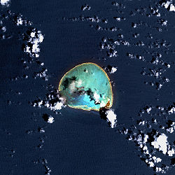
The International Date Line lies approximately Template:Convert to the west. Although located to the west of Midway Atoll, Kure Atoll has a time zone 1 hour ahead at UTC−10:00 (the same as the rest of Hawaii). Kure is the northernmost coral atoll in the world.<ref>Template:Cite book</ref><ref name="Reynolds2012">Template:Cite book</ref> It consists of a Template:Convert nearly circular barrier reef surrounding a shallow lagoon and several sand islets. There is a total land area of Template:Convert, with Green Island on the southeast side.<ref>Template:GNIS</ref> A growing number of Hawaiian monk seals (Monachus schauinslandi) haul out on its beaches.<ref name=Safina>Template:Cite book</ref> The Polynesian rat (Rattus exulans) has been on the island since it was discovered.<ref name=":0">Template:Cite book</ref>
The coral reef is a rough ring shape about Template:Convert across and has two islands within, Sand Island and Green Island. Green Island is in the southeast quadrant of the ring, with an area of 235 acres. Sand Island is about one acre in size and lies to the west of Green Island.<ref name=":0" /> Sand Island is not known to have plant life.<ref name="Starr2001">Template:Cite report</ref>
Green Island has a wide variety of vegetation including groves of beach naupaka (Scaevola taccada), which are a popular habitat for birds.<ref name=":0" /> Another type of tree on Green Island is the heliotrope tree (Tournefortia argentea), there are two groves of ironwood trees (Casuarina equisetifolia), and other common plants are Verbesina and Bermuda grass.<ref name="Starr2001" /> A survey of plant life in 2001 counted about 50 different species of plant on Green Island.<ref name="Starr2001" />
Green Island is roughly triangular with a point to the north and with a northwest beach extending down to a western point.<ref name=":0" /> The east side arcs down from north point and the shore includes east beach, southeast beach, and south beach, which arcs around to West point on the south side of the island.<ref name=":0" /> Overall Green Island is Template:Convert long and up to Template:Convert wide. The highest point is Template:Convert.<ref name=":0" />
Seabirds known to be at Kure in one survey:<ref name=":1">Template:Cite journal</ref>
- Black-footed albatross (Diomedea nigripes)
- Laysan albatross (Diomedea immutabilis)
- Wedge-tailed shearwater (Pufinus pacificlcs)
- Red-tailed tropic-bird (Phaethon rubricauda)
- Blue-faced booby (Sula dactylatra)
- Brown booby (Sula Leucogaster)
- Red-footed booby (Sula sula)
- Great frigate-bird (Fregata minor)
- Gray-backed tern (Sterna lunata)
- Sooty tern (Sterna fuscata)
- Noddy tern (Anous stolidus)
- White-capped noddy tern (Anous minutus)
- White tern (Gygis alba)
As of 2002, 92 species of algae have been discovered in the central lagoon of Kure Atoll.<ref>Template:Cite report</ref>
Geological history and future
The geological history of Kure is generally similar to Midway, but Kure lies close to what is called the Darwin Point, the latitude north of which the rate of natural reef subsidence and destruction surpasses the rate of reef growth. At approximately 30 million years old, it is the oldest in the Hawaiian Island chain. As Kure continues to be slowly carried along to the northwest by the motion of the Pacific Plate, it will move into waters too cool for coral and coralline algae growth to keep up with isostatic subsidence of the mountain. Currently the atoll is warmed by the pools of water at the ends of the warm Kuroshio Current, keeping it in a very comfortable range in winter. Barring unforeseen evolution, it will then begin to join the other volcanic and reef-topped remnants of the Hawaiian–Emperor seamount chain to the northwest, all of which are now seamounts.<ref name=Safina/><ref>{{#invoke:citation/CS1|citation |CitationClass=web }}</ref>
Amateur radio
Because of its particularly remote location, Kure Atoll has been the scene of several amateur radio DX expeditions, or DX-peditions. Because the radio propagation path between Kure and Europe runs right over the North Polar region, opportunities for distant communication with Kure are particularly popular among European amateurs.
The callsign prefix for Kure Atoll as of 2017 is KH7K, and for nearby Midway Atoll KH4, on the DXCC list.<ref name=":10">{{#invoke:citation/CS1|citation |CitationClass=web }}</ref> They were briefly deleted from the DXCC list and had to be re-added after a review, due to a legal change of the overall regions status.<ref name=":10" />
Some of the DXpeditions to Kure were:
- 1969Template:Spaced ndashCallsign: KH6NR/KH6Template:Spaced ndashFrom November 11 to November 14, 1969, Marine Staff Sergeant Don Chilcote, KH6GKV (now VE6NN), and Navy ICFN Gene Lewis, KH6HDB (now W5LE), operated from Kure Island, using the U.S. Navy Reserve Training Center, Honolulu's callsign.<ref name=Cordell>{{#invoke:citation/CS1|citation
|CitationClass=web }}</ref>
- 1970Template:Spaced ndashCallsign: W7UXP/KH6 - October by WB2OIF, KH6HCM/W7UXP, KH6HGP/W7WOX
- 1971–72Template:Spaced ndashCallsign: KH6EDY—The U.S. Coast Guard Kure Island LORAN station's callsign.<ref>{{#invoke:citation/CS1|citation
|CitationClass=web }}</ref>
- 1973–74Template:Spaced ndashCallsign: KH6HDBTemplate:Spaced ndashFrom September 1973 to September 1974, Gene Lewis, KH6HDB (now W5LE), operated from Kure Island. Lewis had been one of the two operators to activate Kure during the one-week DXpedition of KH6NR/KH6 during November 1969. He subsequently joined the Coast Guard for the express purpose of getting to spend a one-year tour of duty on Kure Island.<ref>{{#invoke:citation/CS1|citation
|CitationClass=web }}</ref>
- 1997Template:Spaced ndashEvent call sign: K7K. This was a joint scientific/radio operation including four fish and wildlife scientists and the eight members of the Midway-Kure DX Foundation's 1996 Midway team. The team included four scientists from the United States Fish and Wildlife Service.<ref>{{#invoke:citation/CS1|citation
|CitationClass=web }}</ref>
- 2005Template:Spaced ndashEvent call sign: K7C. The team consisted of 12 amateur radio operators from the United States, Canada, and Germany.<ref name=Cordell/>
- 2018 - the Pacific Island DX-pedition Group's 4th application since 2014 was rejected by the Hawaii Dept. of Land and Natural Resources, citing the inability to provide "adequate safeguards for the resources and ecological integrity" of Kure Atoll, despite successful Amateur Radio activations, with U.S. Fish and Wildlife representation, on Palmyra, Navassa, and Baker Islands with no harmful impact to those island habitats.<ref>Template:Cite journal</ref>
LORAN Station (1960–1992)
Kure's Green Island was home to a radio geolocation station from the early 1960s to 1992.<ref name=":11">Template:Cite book</ref> Called LORAN (short for LOng RAnge Navigation), the base was operated by the U.S. Coast Guard and supported the LORAN-C system. This land-based electronic navigation aid helped ships and aircraft locate themselves on the Earth's surface.<ref name=":11" /> This base was shut down because the LORAN system was superseded by the Global Positioning System (GPS), which uses satellites in Earth orbit rather than ground stations like at Kure Island.<ref name=":11" /> The LORAN station was commissioned on 18 March 1961 and was decommissioned on 2 July 1992.<ref name=":7" />
Kure's LORAN base had a Template:Convert radio tower that was later demolished when operations ended.<ref name=":0" />
The ham radio call sign for the Kure LORAN Station was KH6EDY.<ref name=":7" />
The site was surveyed in 1959 and construction began in 1960.<ref name=":7" /> The survey team was attacked by rats in the night.<ref name=":7" /> The base was staffed by about 20–30 or so personnel, and the base received many awards over its history including the Coast Guard Unit Commendation in 1986–1989.<ref name=":7" />
Airstrip
The Kure airport had one 3800-foot-long runway, and is now closed. Its ICAO code was PM64.<ref name=":6">{{#invoke:citation/CS1|citation |CitationClass=web }}</ref>
Aircraft that routinely operated from the airstrip included U.S. Coast Guard HC-123B Provider and HC-130H aircraft and several types of U.S. Navy fixed-wing aircraft and helicopters from Midway. Flights routinely carried mail, cargo, and passengers to Kure Atoll since its completion in the 1960s.<ref name=":6" />
The airstrip was also known to have been used for emergency landings, including a Lockheed Constellation (C-121) in 1961<ref>{{#invoke:citation/CS1|citation |CitationClass=web }}</ref> and a Boeing 707 in 1966.
Shipwrecks
Kure Atoll is noted as the location of various shipwrecks. Some of the noted wrecks at the atoll include:<ref name=":0" />
- 1837 Gledstanes
- 1842 Parker
- 1870 Saginaw
- 1886 Dunnottar Castle<ref name=":3" />
- 1888 Ocean Pearl
- 1937 Statu Maru
- 1961 Port of Bandon<ref name=":2" />
- 1976 Houei Maru
The wreck of the whaling ship Gledstanes was found in 2008. Many of the crews survived by living on Kure until they could leave the island.<ref>{{#invoke:citation/CS1|citation |CitationClass=web }}</ref>
Gallery
-
 Bathymetric map of Kure Atoll
 -
 Satellite image of Kure Atoll
 -
 NASA astronaut image of Kure Atoll (February 22, 2004)
 -
 Photo of Green Island shot from the air (February 27, 1968)
 -
 Kure Atoll on the horizon
 -
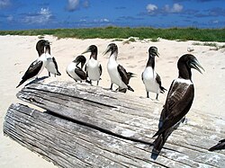 Young masked boobies (Sula dactylatra) on Green Island, Kure Atoll
 -
 Scaevola taccada (habit with sooty terns). Location: Kure Atoll, inland
 -
The flower of Verbesina encelioides at near camp of Kure Atoll
-
Young masked boobies (Sula dactylatra) sitting on marine debris on Green Island.


_(20159194319).jpg)


.jpg)
.jpg)
.jpg)
.jpg)
_(20319578286).jpg)
.jpg)
Climate
Temperatures at Kure Atoll range from about Template:Convert.<ref name=":0" /> There is usually a wind of about Template:Cvt that blows from the northeast trade winds.<ref name=":0" />
The data chart below is taken from Midway Atoll due to a lack of any weather stations present on Kure Atoll.
Kure Atoll features a tropical savanna climate (Köppen Aw) with high year-round temperatures. Rainfall is evenly distributed throughout the year, with only two months being able to be classified as dry season months (May and June).
See also
References
External links
- Quick Facts on the Kure Atoll from the PBS Ocean Adventures site
- Northwestern Hawaiian Islands Coral Reef Ecosystem Reserve
- List of DXpeditions to Kure Island
- Papahānaumokuākea Marine National Monument Information Management System
- State of Hawaii's Department of Land and Natural Resource—Division of Forestry and Wildlife
- Kure Atoll Conservancy
- Kure Island Nautical Chart
- Pages with broken file links
- Atolls of Hawaii
- Bird sanctuaries of the United States
- Cenozoic Hawaii
- Closed facilities of the United States Coast Guard
- Coral reefs of the United States
- Geography of Honolulu County, Hawaii
- Hawaiian–Emperor seamount chain
- Important Bird Areas of Hawaii
- Northwestern Hawaiian Islands
- Oligocene volcanoes
- Paleogene Oceania