Lääne-Viru County
Template:Short description Template:Main other{{#invoke:Infobox|infobox}}Template:Template other{{#invoke:Check for unknown parameters|check|unknown=Template:Main other|preview = Page using [[Template:Template:If empty]] with unknown parameter "_VALUE_"|ignoreblank=y|mapframe_args=y | alt | anthem | anthem_link | area_blank1_acre | area_blank1_dunam | area_blank1_ha | area_blank1_km2 | area_blank1_sq_mi | area_blank1_title | area_blank2_acre | area_blank2_dunam | area_blank2_ha | area_blank2_km2 | area_blank2_sq_mi | area_blank2_title | area_code | area_code_type | area_codes | area_footnotes | area_land_acre | area_land_dunam | area_land_ha | area_land_km2 | area_land_sq_mi | area_metro_acre | area_metro_dunam | area_metro_footnotes | area_metro_ha | area_metro_km2 | area_metro_sq_mi | area_note | area_rank | area_rural_acre | area_rural_dunam | area_rural_footnotes | area_rural_ha | area_rural_km2 | area_rural_sq_mi | area_total_acre | area_total_dunam | area_total_ha | area_total_km2 | area_total_sq_mi | area_urban_acre | area_urban_dunam | area_urban_footnotes | area_urban_ha | area_urban_km2 | area_urban_sq_mi | area_water_acre | area_water_dunam | area_water_ha | area_water_km2 | area_water_percent | area_water_sq_mi | blank_emblem_alt | blank_emblem_link | blank_emblem_size | blank_emblem_type | blank_emblem_sizedefault | blank_emblem_upright | blank_info | blank_info_sec1 | blank_info_sec2 | blank_name | blank_name_sec1 | blank_name_sec2 | blank1_info | blank1_info_sec1 | blank1_info_sec2 | blank1_name | blank1_name_sec1 | blank1_name_sec2 | blank2_info | blank2_info_sec1 | blank2_info_sec2 | blank2_name | blank2_name_sec1 | blank2_name_sec2 | blank3_info | blank3_info_sec1 | blank3_info_sec2 | blank3_name | blank3_name_sec1 | blank3_name_sec2 | blank4_info | blank4_info_sec1 | blank4_info_sec2 | blank4_name | blank4_name_sec1 | blank4_name_sec2 | blank5_info | blank5_info_sec1 | blank5_info_sec2 | blank5_name | blank5_name_sec1 | blank5_name_sec2 | blank6_info | blank6_info_sec1 | blank6_info_sec2 | blank6_name | blank6_name_sec1 | blank6_name_sec2 | blank7_info | blank7_info_sec1 | blank7_info_sec2 | blank7_name | blank7_name_sec1 | blank7_name_sec2 | caption | code1_info | code1_name | code2_info | code2_name | coor_pinpoint | coor_type | coordinates | coordinates_footnotes | demographics_type1 | demographics_type2 | demographics1_footnotes | demographics1_info1 | demographics1_info10 | demographics1_info2 | demographics1_info3 | demographics1_info4 | demographics1_info5 | demographics1_info6 | demographics1_info7 | demographics1_info8 | demographics1_info9 | demographics1_title1 | demographics1_title10 | demographics1_title2 | demographics1_title3 | demographics1_title4 | demographics1_title5 | demographics1_title6 | demographics1_title7 | demographics1_title8 | demographics1_title9 | demographics2_footnotes | demographics2_info1 | demographics2_info10 | demographics2_info2 | demographics2_info3 | demographics2_info4 | demographics2_info5 | demographics2_info6 | demographics2_info7 | demographics2_info8 | demographics2_info9 | demographics2_title1 | demographics2_title10 | demographics2_title2 | demographics2_title3 | demographics2_title4 | demographics2_title5 | demographics2_title6 | demographics2_title7 | demographics2_title8 | demographics2_title9 | dimensions_footnotes | dunam_link | elevation_footnotes | elevation_ft | elevation_link | elevation_m | elevation_max_footnotes | elevation_max_ft | elevation_max_m | elevation_max_point | elevation_max_rank | elevation_min_footnotes | elevation_min_ft | elevation_min_m | elevation_min_point | elevation_min_rank | elevation_point | embed | established_date | established_date1 | established_date2 | established_date3 | established_date4 | established_date5 | established_date6 | established_date7 | established_title | established_title1 | established_title2 | established_title3 | established_title4 | established_title5 | established_title6 | established_title7 | etymology | extinct_date | extinct_title | flag_alt | flag_border | flag_link | flag_size | footnotes | founder | geocode | governing_body | government_footnotes | government_type | government_blank1_title | government_blank1 | government_blank2_title | government_blank2 | government_blank2_title | government_blank3 | government_blank3_title | government_blank3 | government_blank4_title | government_blank4 | government_blank5_title | government_blank5 | government_blank6_title | government_blank6 | grid_name | grid_position | image_alt | image_blank_emblem | image_caption | image_flag | image_map | image_map1 | image_seal | image_shield | image_size | image_skyline | imagesize | image_sizedefault | image_upright | iso_code | leader_name | leader_name1 | leader_name2 | leader_name3 | leader_name4 | leader_name5 | leader_party | leader_title | leader_title1 | leader_title2 | leader_title3 | leader_title4 | leader_title5 | length_km | length_mi | map_alt | map_alt1 | map_caption | map_caption1 | mapsize | mapsize1 | module | motto | motto_link | mottoes | name | named_for | native_name | native_name_lang | nickname | nickname_link | nicknames | official_name | other_name | p1 | p10 | p11 | p12 | p13 | p14 | p15 | p16 | p17 | p18 | p19 | p2 | p20 | p21 | p22 | p23 | p24 | p25 | p26 | p27 | p28 | p29 | p3 | p30 | p31 | p32 | p33 | p34 | p35 | p36 | p37 | p38 | p39 | p4 | p40 | p41 | p42 | p43 | p44 | p45 | p46 | p47 | p48 | p49 | p5 | p50 | p6 | p7 | p8 | p9 | parts | parts_style | parts_type | pop_est_as_of | pop_est_footnotes | population | population_as_of | population_blank1 | population_blank1_footnotes | population_blank1_title | population_blank2 | population_blank2_footnotes | population_blank2_title | population_demonym | population_demonyms | population_density_blank1_km2 | population_density_blank1_sq_mi | population_density_blank2_km2 | population_density_blank2_sq_mi | population_density_km2 | population_density_metro_km2 | population_density_metro_sq_mi | population_density_rank | population_density_rural_km2 | population_density_rural_sq_mi | population_density_sq_mi | population_density_urban_km2 | population_density_urban_sq_mi | population_est | population_footnotes | population_metro | population_metro_footnotes | population_note | population_rank | population_rural | population_rural_footnotes | population_total | population_urban | population_urban_footnotes | postal_code | postal_code_type | postal2_code | postal2_code_type | pushpin_image | pushpin_label | pushpin_label_position | pushpin_map | pushpin_map_alt | pushpin_map_caption | pushpin_map_caption_notsmall | pushpin_map_narrow | pushpin_mapsize | pushpin_outside | pushpin_overlay | pushpin_relief | registration_plate | registration_plate_type | seal_alt | seal_link | seal_size | seal_type | seat | seat_type | seat1 | seat1_type | seat2 | seat2_type | settlement_type | shield_alt | shield_link | shield_size | short_description | subdivision_name | subdivision_name1 | subdivision_name2 | subdivision_name3 | subdivision_name4 | subdivision_name5 | subdivision_name6 | subdivision_type | subdivision_type1 | subdivision_type2 | subdivision_type3 | subdivision_type4 | subdivision_type5 | subdivision_type6 | template_name | timezone | timezone_DST | timezone_link | timezone1 | timezone1_DST | timezone1_location | timezone2 | timezone2_DST | timezone2_location | timezone3 | timezone3_DST | timezone3_location | timezone4 | timezone4_DST | timezone4_location | timezone5 | timezone5_DST | timezone5_location | total_type | translit_lang1 | translit_lang1_info | translit_lang1_info1 | translit_lang1_info2 | translit_lang1_info3 | translit_lang1_info4 | translit_lang1_info5 | translit_lang1_info6 | translit_lang1_type | translit_lang1_type1 | translit_lang1_type2 | translit_lang1_type3 | translit_lang1_type4 | translit_lang1_type5 | translit_lang1_type6 | translit_lang2 | translit_lang2_info | translit_lang2_info1 | translit_lang2_info2 | translit_lang2_info3 | translit_lang2_info4 | translit_lang2_info5 | translit_lang2_info6 | translit_lang2_type | translit_lang2_type1 | translit_lang2_type2 | translit_lang2_type3 | translit_lang2_type4 | translit_lang2_type5 | translit_lang2_type6 | type | unit_pref | utc_offset | utc_offset_DST | utc_offset1 | utc_offset1_DST | utc_offset2 | utc_offset2_DST | utc_offset3 | utc_offset3_DST | utc_offset4 | utc_offset4_DST | utc_offset5 | utc_offset5_DST | website | width_km | width_mi }}{{#invoke:Check for clobbered parameters|check | template = [[Template:Template:If empty]] | cat = Template:Main other | population; population_total | image_size; imagesize | image_alt; alt | image_caption; caption | settlement_type; type | utc_offset1; utc_offset | timezone1; timezone }}{{#if:
|
}}Template:Main other{{#ifexpr:{{#invoke:ParameterCount|main|mapframe|image_map|image_map1|pushpin_map}} >2 |Template:Main other}} Lääne-Viru County (Template:Langx or Lääne-Virumaa) is one of 15 counties of Estonia. It is in northern Estonia, on the south coast of the Gulf of Finland. In Estonian, lääne means 'western' and ida means 'east' or 'eastern'. Lääne-Viru borders Ida-Viru County to the east, Jõgeva County to the south, and Järva and Harju counties to the west. In January 2013, Lääne-Viru County had a population of 58,806, or 4.5% of the population of Estonia.<ref name="County_population">{{#invoke:citation/CS1|citation |CitationClass=web }}</ref>
History
In prehistoric times, Lääne-Virumaa was settled by Estonians of the Vironian tribe.
County government
Until 2017, the County Government (Template:Langx), seated in Rakvere, was led by a governor (Template:Langx), who was appointed by the Government of Estonia. Since 2014, the governor position was held by Marko Torm.
Municipalities
The county is subdivided into municipalities. There is one urban municipality (Template:Langx 'towns') and seven rural municipalities (Template:Langx 'parishes') in Lääne-Viru County.
| Rank | Municipality | Type | citation | CitationClass=web
}}</ref>!! Area | |
|---|---|---|---|---|---|
| 1 | Haljala Parish | Rural | 4,389 | 547 | 8.0 |
| 2 | Kadrina Parish | Rural | 4,958 | 355 | 14.0 |
| 3 | Rakvere Parish | Rural | 5,566 | 296 | 18.8 |
| 4 | Rakvere | Urban | 15,613 | 11 | 1,419.4 |
| 5 | Tapa Parish | Rural | 11,252 | 479 | 23.5 |
| 6 | Vinni Parish | Rural | 6,919 | 1,013 | 6.8 |
| 7 | Viru-Nigula Parish | Rural | 5,981 | 311 | 19.2 |
| 8 | Väike-Maarja Parish | Rural | 6,016 | 683 | 8.8 |

Religion
The largest number of congregations in the county are of the Estonian Evangelical Lutheran Church (EELC): in Haljala, Kunda, Kadrina, Käsmu, Rakvere, Simuna, Tamsalu, Viru-Jaagupi, Viru-Nigula and Väike-Maarja under EELC's Viru Deanery and in Tapa under EELC's Järva Deanery.<ref name="eelk.ee">{{#invoke:citation/CS1|citation |CitationClass=web }}</ref>
Eastern Orthodox congregations in the county are predominantly under the administration of the Estonian Apostolic Orthodox Church<ref name="orthodoxa.org">{{#invoke:citation/CS1|citation |CitationClass=web }}</ref> but some of them are also under the Estonian Orthodox Church of the Moscow Patriarchate.<ref name="et.orthodox.ee">{{#invoke:citation/CS1|citation |CitationClass=web }}</ref>
Several congregations of Baptists, a catholic congregation in Rakvere and other Christian churches operate in the county.
| CitationClass=web
}}
|
CitationClass=web
}}
|
CitationClass=web
}}
|
CitationClass=web
}}
|
CitationClass=web
}}
|
CitationClass=web
}} </ref> | |
| Religion | 2000 | 2011 | 2021 | |||
|---|---|---|---|---|---|---|
| Number | % | Number | % | Number | % | |
| Christianity | 10,764 | 19.9 | 8,429 | 16.7 | 8,040 | 15.9 |
| —Orthodox Christians | 2,152 | 4.0 | 2,777 | 5.5 | 3,040 | 6.1 |
| —Lutherans | 7,498 | 12.9 | 4,755 | 9.4 | 3,730 | 7.5 |
| —Catholics | 162 | 0.3 | 98 | 0.2 | 120 | 0.2 |
| —Baptists | 294 | 0.5 | 166 | 0.3 | 190 | 0.4 |
| —Jehovah's Witnesses | 234 | 0.4 | 187 | 0.3 | 170 | 0.3 |
| —Pentecostals | 135 | 0.2 | 102 | 0.2 | 170 | 0.3 |
| —Old Believers | 10 | 0.01 | 20 | 0.03 | - | - |
| —Methodists | 136 | 0.2 | 77 | 0.1 | 40 | 0.08 |
| —Adventists | 143 | 0.2 | 76 | 0.1 | 160 | 0.3 |
| —Other Christians | - | - | 171 | 0.3 | 420 | 0.8 |
| Islam | 23 | 0.03 | 26 | 0.05 | 20 | 0.04 |
| Buddhism | - | - | 30 | 0.05 | 50 | 0.1 |
| Other religions** | 237 | 0.4 | 361 | 0.7 | 680 | 1.3 |
| No religion | 24,820 | 46.0 | 35,239 | 69.8 | 35,790 | 72.3 |
| Not stated*** | 10,249 | 19.0 | 6,444 | 12.7 | 4,910 | 9.9 |
| Total population* | 53,957 | 50,425 | 49,490 | |||
| *The censuses of Estonia count the religious affiliations of the population older than 15 years of age.<ref name="Census" /> ".<ref name="Census" /> | ||||||
Geography
Gallery
-
 Porkuni Castle gate tower
 -
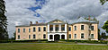
 Palmse manor
 -
 Rakvere Castle
 -
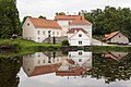
 Mõdriku manor
 -
 Malla manor
 -
 Vihula windmill
 -
 Laekvere pine
 -
 Lake Neeruti Tagajärv
 -
 View from tower on the hill of Emumägi
 -
 Toolse Castle
 -
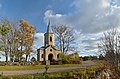 Vainupea Chapel
 -
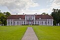
 Vihula Manor
 -
 Altja river
 -
 Sagadi manor
 -
 Viru bog in Lahemaa National Park
 -
 Mähu boulders in Lahemaa National Park
 -
 Rapeseed field near Laekvere


References
External links
{{#invoke:Navbox|navbox}} Template:Authority control