Laguna de Bay
Template:Short description Template:Use Philippine English Template:Use mdy dates Template:Infobox body of water
Laguna de Bay (Spanish for "Lagoon/Lake of Bay"; Template:Langx, {{#invoke:IPA|main}}), also known as Laguna Lake and alternatively spelled "Laguna de Bae",<ref>{{#invoke:citation/CS1|citation |CitationClass=web }}</ref> is the largest lake in the Philippines. Laguna de Bay remains one of the most important freshwater resources in the Philippines, supporting millions of residents through fisheries, agriculture, and domestic use. It is located southeast of Metro Manila, between the provinces of Laguna to the south and Rizal to the north. The freshwater lake has a surface area of 911–949 km2 (352–366 sq mi), with an average depth of about Template:Convert and an elevation of about one meter above sea level. It is shaped like a crow's foot, with two peninsulas jutting out from the northern shore and filling the large volcanic Laguna Caldera. In the middle of the lake is the large island of Talim.
The lake is one of the primary sources of freshwater fish in the country. Its water drains to Manila Bay via the Pasig River. Environmental issues such as water quality problems created by population pressure and industrialization, invasive species, and overfishing are of concern to the lake, hurting its economic importance to the country. As the population expands in the Bay, it is expected to rely more heavily on the lake as a source of freshwater. Thus, water quality directly affects human populations.<ref>Template:Cite journal</ref>
Etymology
Laguna de Bay means "Lagoon of [the town of] Bay" for the lakeshore town of Bay (pronounced Bä'ï), the former provincial capital of Laguna province.<ref name="feleosheniak">Template:Citation</ref> Alternate spellings of the town's name include "Bae" or "Ba-i", and in early colonial times, "Bayi" or "Vahi". The town's name is believed to have come from the Tagalog word for "settlement" (bahayan), and is related to the words for "house" (bahay), "shore" (baybayin), and "boundary" (baybay), among others. The introduction of the English language during the American administration of the Philippines, elicited confusion as the English word "bay", referring to another body of water, was mistakenly substituted for the town name that led to its mispronunciation.<ref name="feleosheniak" /> However, the word "Bay" in Laguna de Bay has always referred to the town.<ref name="odaluniliever">Template:Citation</ref>
The Spanish word laguna refers to not just lagoons but also to freshwater lakes, aside from lago.<ref>"Laguna". Spanish Dict. Retrieved on October 18, 2012.</ref> This would make the lake's alternate name, "Laguna Lake", tautological. However, the "Laguna" in "Laguna Lake" refers to the province of Laguna, the province at the southern shore of the lake, and not the lake itself. The province, though, was in turn named after the lake and was originally called La Laguna until the early 20th century.<ref>U.S. Bureau of Census (1905). "Census of the Philippine Islands, 1903, Vol. II". Government Printing Office, Washington.</ref>
In the pre-Hispanic era, the lake was known as "Puliran Kasumuran" (Laguna Copperplate Inscription, Template:Circa 900 AD), and later by "Pulilan" (Vocabulario de la lengua tagala, 1613. Pila, Laguna).
Currently, the lake is often incorrectly called "Laguna Bay," including in government websites, or "Laguna Lake", which is used by the Laguna Lake Development Authority.<ref>{{#invoke:citation/CS1|citation |CitationClass=web }}</ref>
Geography
Laguna de Bay is a large shallow freshwater body in the heart of Luzon Island with an aggregate area of about Template:Convert and a shoreline of Template:Convert.<ref name=LLDA1995_4/> It is considered to be the third largest inland body of water in Southeast Asia after Tonle Sap in Cambodia and Lake Toba in Sumatra, Indonesia. Laguna de Bay is bordered by the province of Laguna in the east, west and southwest, the province of Rizal in the north to northeast, and Metropolitan Manila in the northwest. The lake has an average depth of Template:Convert and its excess water is discharged through the Pasig River.<ref name=Gonzales1987>Gonzales, E. (1987). "A socio economics geography (1961–85) of the Laguna lake resources and its implications to aquatic resources management and development of the Philippine islands" Dissertation. Cambridge University, England, United Kingdom</ref><ref name=Guerrero1998>Guerrero, R. & Calpe, A. T. (1998). "Water resources management : A global priority". National Academy of Science and Technology, Manila, Philippines</ref>
The middle part of Laguna de Bay between Mount Sembrano and Talim Island, is the Laguna Caldera believed to have been formed by two major volcanic eruptions, around 1 million and 27,000–29,000 years ago. Remnants of its volcanic history are shown by the presence of a series of maars around the area of Tadlac Lake and Mayondon hill in Los Baños, Laguna,<ref>Santos-Borja, Adelina C. (2008). "Multi-Stakeholders' Efforts for the Sustainable Management of Tadlac Lake, The Philippines" Template:Webarchive. Research Center for Sustainability and Environment, Shiga University.</ref> another maar at the southern end of Talim Island, and a solfataric field in Jala Jala.<ref name="gvp"> Template:Cite gvp</ref>
Islands
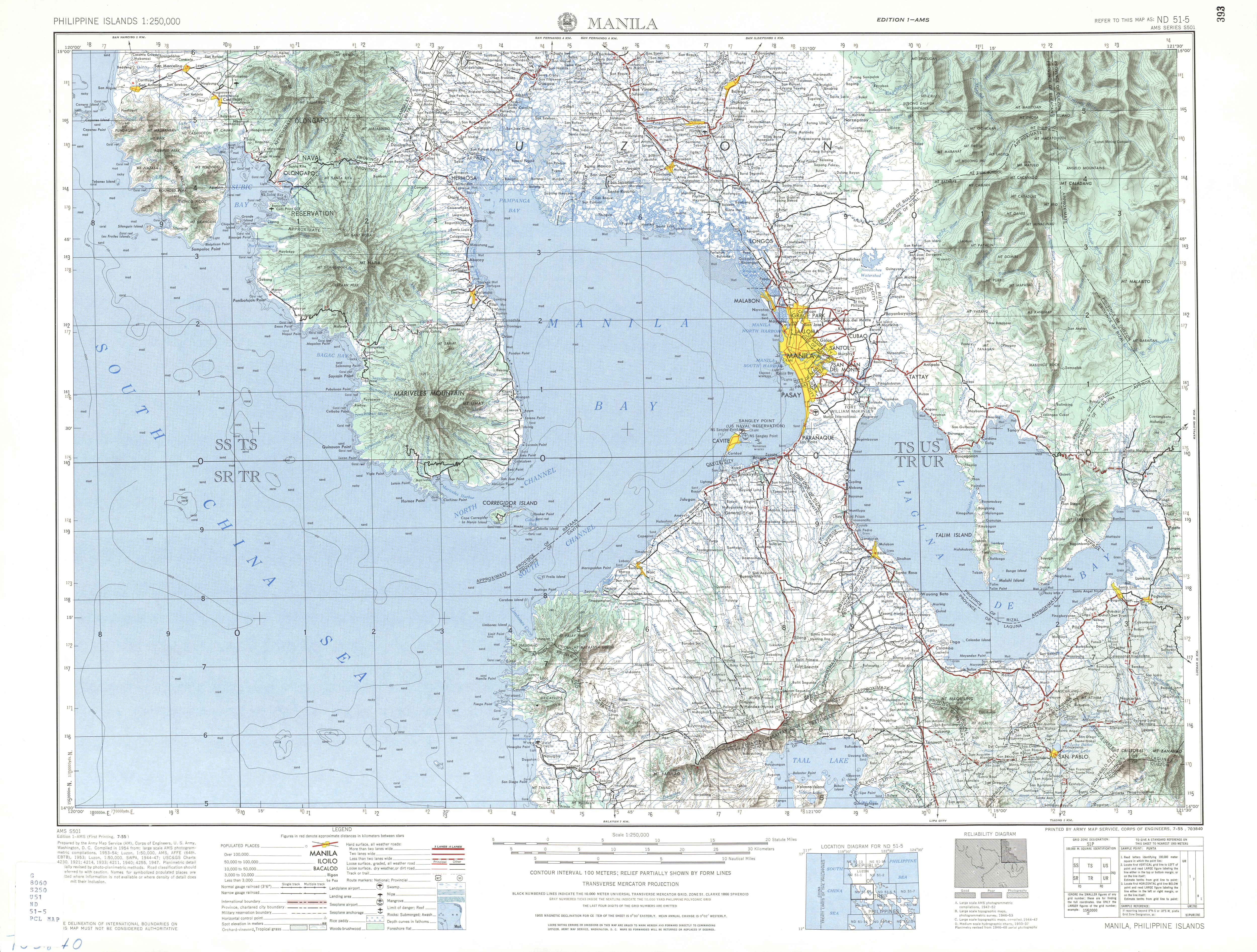
Known lake islands include Talim, the largest and most populated island on the lake;<ref name="coe1954">U.S. Army corps of Engineers (1954). "Manila (topographical map)". University of Texas in Austin Library. Retrieved on 2014-08-03.</ref> Calamba Island, which is completely occupied by the Wonder Island resort in Calamba, Laguna;<ref name="coe1954"/> Cielito Lindo, a privately owned island off the coast of mainland Cardona, Rizal;<ref name="coe1954"/><ref name="philstar.com">{{#invoke:citation/CS1|citation |CitationClass=web }}</ref> Malahi Island which used to be the site of Maligi Island military reservation, near the southern tip of Talim;<ref name="coe1954"/><ref name="books.google.com.ph">Template:Cite book</ref> the nearby islands of Bonga and Pihan, also in Cardona; and Bay Island off the coast of Bay, Laguna, which is closely associated with the precolonial crocodile-deity myths of that town.<ref name="odaluniliever"/>
Tributaries
The lake is fed by Template:Convert of catchment areas and its 21 major tributaries. Among these are the Pagsanjan River which is the source of 35% of the Lake's water, the Santa Cruz River which is the source of 15% of the Lake's water, the Marikina River (through the Manggahan Floodway), the Mangangate River, the Tunasan River, the San Pedro River, the Cabuyao River, the San Cristobal River, the San Juan River, the Bay, Calo and Maitem rivers in Bay, the Molawin, Dampalit and Pele rivers in Los Baños, the Pangil River, the Tanay River, the Morong River, the Siniloan River and the Sapang Baho River.<ref name=LLDA1995_4>LLDA 1995, p. 4.</ref> <ref>Template:Cite conference</ref>
The lake is primarily drained through the Pasig River, which is technically a tidal estuary instead of a unidirectional "river."
Uses
The lake is a multipurpose resource,<ref>LLDA 1995, pp. 4–6.</ref> used for fishery, transportation, irrigation of agricultural lands, power generation, and as a reservoir for regional flood management, among other things.
The lake has been used as a navigation lane for passenger boats since the Spanish colonial era. It is also used as a source of water for the Kalayaan Pumped-Storage Hydroelectric Project in Kalayaan, Laguna. Other uses include fishery, aquaculture, recreation, food support for the growing duck industry, irrigation and a "virtual" cistern for domestic, agricultural, and industrial effluents.<ref name=Gonzales1987 />
On December 15, 2023, Marcos, Jr., assisted by Maynilad president and CEO Ramoncito Fernandez, MWSS administrator, Leonor Cleofas and Manuel Pangilinan inaugurated Maynilad Water Services’s P11-billion Poblacion Water Treatment Plant in Muntinlupa City. The operation and maintenance of the Laguna Lake Drinking Water Treatment Plant was awarded by Maynilad Water Services to Acciona, CEO José Díaz-Caneja, and D.M Consulting Inc.-DMCI Holdings, Inc. It will process 150 million liters of drinking water a day from Laguna de Bay.<ref>Template:Cite news</ref><ref>Template:Cite news</ref>
Environmental issues
Template:Further Because of its importance in the development of the Laguna de Bay Region, unlike other lakes in the country, its water quality and general condition are closely monitored.<ref>Department of Environment and Natural Resources, 1996</ref> This important water resource has been greatly affected by development pressures like population growth, rapid industrialization, and resource allocation.<ref name=Batu1996>Batu, M. (1996) Factors affecting productivity of selected inland bodies of water in the Philippines: The case of the Laguna Lake 1986 to 1996. Undergraduate thesis. San Beda College, Manila.</ref>
Invasive species
At least 18 fish species are known from Laguna de Bay; none are strictly endemic to the lake, but 3 are endemic to the Philippines: Gobiopterus lacustris, Leiopotherapon plumbeus and Zenarchopterus philippinus.<ref>Template:Cite journal</ref> Aquaculture is widespread in Laguna de Bay, but often involves non-native species.<ref>Santos-Borja, A., and D.N. Nepomuceno (2005). Laguna de Bay, Experiences and lessons learned brief Template:Webarchive, pp. in: 225–258 in: Lake Basin Management Initiative. Retrieved 13 November 2012</ref> Some of these, such as the janitor fish, clown knifefish, Thai catfish, and blackchin tilapia,<ref>Template:Cite news</ref> have escaped and have become invasive species, representing a threat to native fish.<ref>Template:Cite journal</ref>
Pollution
Government data showed that about 60% of the estimated 8.4 million people residing in the Laguna de Bay Region discharge their solid and liquid wastes indirectly to the lake through its tributaries. A large percentage of these wastes are mainly agricultural while the rest are either domestic or industrial<ref>DENR, 1997</ref> According to DENR (1997), domestic and industrial wastes contribute almost equally at 30% each. Meanwhile, agricultural waste takes up the remaining 40%. In a recent sensitivity waste load model ran by the Laguna Lake Development Authority's (LLDA) Integrated Water Resources Management (IWRM) division, it revealed that 70% of biochemical oxygen demand (BOD) loadings came from households, 19% from industries, and 11% came from land run-off or erosion (LLDA, 2005).
As far as industries and factories are concerned, there are about 1,481 and an increase is expected.<ref name=Guerrero1998 /> Of the said figure, about 695 have wastewater treatment facilities. Despite this, the lake is absorbing huge amounts of pollution from these industries in the form of discharges of industrial cooling water, toxic spills from barges and transport operations, and hazardous chemicals like lead, mercury, aluminum and cyanide.<ref>Sly, 1984</ref> Based on the said figure, 65% are classified as "pollutive" industries.
The hastened agricultural modernization throughout the region took its toll on the lake. This paved the way for massive and intensified use of chemical based fertilizers and pesticides whose residues eventually found their way to the lake basin. These chemicals induce rapid algal growth in the area that depletes oxygen levels in the water. Hence, oxygen available to the lake is being used up thereby depleting the available oxygen for the fish, causing massive fish kills.<ref name=SPP1992>Solidarity for People's Power (1992) Laguna de bay: Racing against time. Pamphlet article. Los Baños, Laguna, Philippines.</ref> A 2012 study found excessive pesticide use largely attributed to overapplication of pesticides close to waterways.<ref>Template:Cite journal</ref>
As far as domestic wastes are concerned, around 10% of the Template:Convert of waste generated by residents of Metro Manila is dumped into the lake, causing siltation of the lake. As reported by the now defunct Metropolitan Manila Waterworks and Sewerage System (MWSS), only 15% of the residents in the area have an effective waste disposal system. Moreover, around 85% of the families living along the shoreline do not have toilets and/or septic tanks.<ref name=Batu1996 /><ref name=SPP1992 />
In 2018 a survey on Microplastics were conducted by researchers from the Polytechnic University of the Philippines, and have found out that the Laguna de Bay is heavily polluted with microplastics. The study involved three (3) barangays and these are Napindan, San Isidro, and Sampiruhan. Among the barangays, Sampiruhan in Calamba, Laguna has the most microplastics, with a median of 15 ranging from 11 to 24 microplastics per 1000 liters of lake water.<ref>Deocaris, C.C., Fernandez, M.C., Lee, A.R., Miao, S.L.A., and Padolina, J.B.P.(2023). Identification and Characterization of Microplastics on the Surface Water in Laguna de Bay, Philippines. Nature Environment and Pollution Technology. Volume 22, Issue 2, Pages: 1073-1080. Retrieved from: https://neptjournal.com/upload-images/(55)D-1429.pdf</ref> The data from the conducted survey is available in Mendeley Data.<ref>Deocaris, Chester; Fernandez, Martin ; Lee, Angelika; Miao, Sermel Louie; Padolina, Jan Bernel (2022), "Survey of Microplastics in Laguna de Bay 2018", Mendeley Data, V1, doi: 10.17632/bxd3k2yntp.1</ref>
Overfishing
On January 29, 2008, the Mamamayan Para sa Pagpapanatili ng Pagpapaunlad ng Lawa ng Laguna (Mapagpala) accused the Laguna Lake Development Authority (LLDA) of the deterioration of Laguna de Bay due to multiplication of fish pens beyond the allowable limit.<ref>{{#invoke:citation/CS1|citation |CitationClass=web }}</ref>
Infrastructure
Manggahan floodway
Laguna Lakeshore Expressway Dike
Template:ExcerptThe project was initially conceived as a public-private partnership project, but the project was not successful in receiving bids.<ref>Template:Cite news</ref> The project would later be revised as an untolled highway, known as the Laguna Lakeshore Road Network (LLRN) under a new proposal. The highway project has a total length of about 37.4 kilometers (km) expressway from Lower Bicutan in NCR to Calamba in Laguna Province, consisting of (i) 11.7 km long viaduct from Lower Bicutan to Tunasan; and (ii) 25.7km long combination of shoreline viaduct and embankment from Tunasan to Calamba. The expressway will be an access-controlled road with eight interchanges, with an access road at each interchange to connect to the existing road networks.<ref>{{#invoke:citation/CS1|citation |CitationClass=web }}</ref> The Export-Import Bank of Korea-Economic Development Cooperation Fund (KEXIM-EDCF) and the Asian Development Bank (ADB) will jointly finance the project.<ref>{{#invoke:citation/CS1|citation |CitationClass=web }}</ref>
Eastbay Submarine Pipeline and Pakil Water Treatment Plant Projects
The Manila Water began laying down in 2021 two high density polyethylene (HDPE) underground and 21 km submarine pipes from Binangonan, Cardona, Morong, and Pililla to expand their services under the East Bay Phase 1 Project. These two pipes once completed will deliver 50 million liters per day (MLD) to the said area. The environmental impact of the project was worked on by the University of the Philippines Los Baños.<ref name="LinkedIn">{{#invoke:citation/CS1|citation |CitationClass=web }}</ref><ref name="Inquirer 07272022">Template:Cite news</ref>
East Bay Phase 2 Project will involve construction of a water treatment plant (WTP) at Bgy. Kabulusan, Pakil, Laguna beginning 2023. The WTP once completed will produce 200 MLD for the Metro Manila East Zone through the submarine pipeline under the lake.<ref name="Manila Water 1">{{#invoke:citation/CS1|citation |CitationClass=web }}</ref><ref name="Water Waste Water Asia">{{#invoke:citation/CS1|citation |CitationClass=web }}</ref>
Governance
{{#invoke:Labelled list hatnote|labelledList|Main article|Main articles|Main page|Main pages}} The main agency tasked with overseeing the programs that aimed to develop and protect Laguna de Bay is the Laguna Lake Development Authority (LLDA), signed into law under Republic Act (RA) 4850 in 1966 during the Marcos administration.<ref>"Republic Act no. 4850"Template:Dead link. Laguna Lake Development Authority. Retrieved on 2012-10-22.</ref> Originally only created as a quasi-government agency with regulatory and proprietary functions, its charter was strengthened by Presidential Decree (PD) 817 in 1975 and by Executive Order (EO) 927 in 1983 to include environmental protection and jurisdiction over the surface waters of the lake basin. In 1993, by virtue of the devolution, the administrative supervision of the LLDA was transferred to the DENR by EO 149.<ref>LLDA 2009, p. 9.</ref>
Clean Water Act
The technical aspect regarding the quality of wastewater is given in DENR Administrative Order 1990–35. The order defines the critical water parameters' value versus the classification of the body of water (e.g., lake or river). Discharge permits are issued by the LLDA only if the wastewater being discharged complies with the said order.<ref>Department of Environment and Natural Resources (1990). Administrative Order No. 35, March 20, 1990 'Revised Effluent Regulations of 1990, Revising and Amending the Effluent Regulations of 1982'. Template:Webarchive DENR Website. Retrieved on 2012-10-20.</ref>
According to the Clean Water Act of 2004, the DENR (through the LLDA) shall implement a wastewater charge system in all management areas including the Laguna Lake region and Regional Industrial Centers through the collection of wastewater charges/fees. The system shall be established on the basis of payment to the government for discharging wastewater into the water bodies. Wastewater charges shall be established taking into consideration the following: a) to provide strong economic inducement for polluters to modify their production or management processes or to invest in pollution control technology in order to reduce the amount of water pollutants generated; b) to cover the cost of administering water quality management or improvement programs, including the cost of administering the discharge permitting and water pollution charge system; c) reflect damages caused by water pollution on the surrounding environment, including the cost of rehabilitation; d) type of pollutant; e) classification of the receiving water body; and f) other special attributes of the water body.<ref>Department of Environment and Natural Resources (2005). "Implementing Rules and Regulations of the Clean Water Act of 2004 (Republic Act no. 9275)." Template:Webarchive DENR Website. Retrieved on 2012-10-20.</ref>
Integrated Coastal Ecosystem Conservation and Adaptive Management
CECAM is a 5-year research cooperation between Japanese and Filipino scientists. Seven monitoring instruments are being used as part of the Continuous and Comprehensive Monitoring System (CCMS) provided by the Japanese government.<ref>{{#invoke:citation/CS1|citation |CitationClass=web }}Template:Dead link</ref>
Cultural impact
Laguna de Bay has had a significant impact on the cultures of the communities that grew up around its shores, ranging from folk medicine to architecture. For example, the traditional cure for a child constantly experiencing a nose bleed in Victoria, Laguna is to have the child submerge his or her head in the lake water at daybreak.<ref>Template:Cite thesis</ref> When nipa huts were more common, huts made in the lake area were constructed out of bamboo that would first be cured in the waters of Laguna de Bay.<ref>Template:Cite news</ref> Some experts on the evolution of local mythologies suggest that the legend of Mariang Makiling may have started out as that of the Lady (Ba'i) of Laguna de Bay, before the legend was transmuted to Mount Makiling.<ref>Template:Cite book</ref>
Mythology
Maria Makiling is a diwata and guardian spirit known for watching over both the mountain that bears her name and the nearby lake, Laguna de Bay. She is often described as a beautiful fairy maiden, surrounded by tiny winged fairies called lambana. As the protector of the mountain and its resources, she helps the people who live nearby by making sure the land stays rich and fruitful. Many legends say that Laguna de Bay and the fish within it are also under her care. She was sent by Bathalà, the supreme god, to guide and support the people in their daily lives.<ref>Perdon, Renato (2012). Pocket Tagalog Dictionary: Tagalog-English English-Tagalog. Tuttle Publishing, 2012. Template:ISBN</ref><ref>Lanuza, Michelle, The Legend of Maria Makiling, archived from the original on 2007-10-02, retrieved September 30, 2007</ref> <ref>Template:Cite journal</ref><ref>{{#invoke:citation/CS1|citation |CitationClass=web }}</ref> <ref name="pinoymountaineer">Template:Citation</ref>
See also
- Laguna Lake Development Authority
- Laguna Lakeshore Expressway Dike
- Rehabilitation of the Pasig River
References
Sources
- Laguna Lake Development Authority, LLDA (2009). "2009 Annual Report".
- Laguna Lake Development Authority, LLDA (1995). "Laguna de Bay Master Plan – Final Report".
Further reading
- Alviar, Rene M. (1996, November 7). “Laguna lake revival plan set for next three years." Philippine Daily Inquirer as cited in Laguna de Bay: The Living Lake - Page 151 (Ed. R.G. Alejandro)
- Canonoy, F. V. (1997). Lake Laguna's environmental user fee system.
- Laguna Lake Development Authority. "Frequently Asked Questions (archived 2007-06-08)".
- McKitrick, R. (1999). A derivation of the marginal abatement cost curve. Template:Webarchive
- National Statistical Coordination Board (1996). Estimation of fish biomass in Laguna de Bay based on primary productivity.
External links
- Template:Commons category-inline
- Template:OSM relation
- Laguna Lake Development Authority
- Department of Environment and Natural Resources
Template:Laguna de Bay Template:Lakes of the Philippines Template:Laguna Special Zones Template:Metro Manila Template:Authority control