List of Pennsylvania state parks
Template:Short description Template:Use mdy dates Template:Featured list Template:Image frame Template:As of, there are 124 state parks in the U.S. state of Pennsylvania.<ref>{{#invoke:citation/CS1|citation |CitationClass=web }}</ref> The Pennsylvania Bureau of State Parks, a division of the Pennsylvania Department of Conservation and Natural Resources (DCNR), is the governing body for all these parks, and directly operates 116 of them. The remaining parks are operated in cooperation with other public and private organizations.Template:Ref label
The first Pennsylvania state park, at Valley Forge, opened in 1893 and was given to the National Park Service (NPS) for the United States Bicentennial in 1976. There are a total of seventeen former Pennsylvania state parks: four former parks have been transferred to the NPS, four to the Pennsylvania Historical Museum Commission, two to the U.S. Army Corps of Engineers, one to both the Corps and the Pennsylvania Game Commission, five to the Pennsylvania Bureau of Forestry, and one has ceased to exist. Nine current and two former state parks have had major name changes or have been known under alternate names.
The list gives an overview of Pennsylvania state parks and a brief history of their development since the first park opened in 1893. State parks range in size from Template:Convert to Template:Convert and comprise one percent of Pennsylvania's total land area.<ref>{{#invoke:citation/CS1|citation |CitationClass=web }}</ref> According to Dan Cupper (1993), "Pennsylvania is the thirty-third largest state, but only Alaska and California have more park land".<ref name="heritage">{{#invoke:citation/CS1|citation |CitationClass=web }} Note: URL is to Pennsylvania Department of Environmental Protection reprint of article</ref><ref name="cupper">Template:Cite book</ref>
Overview
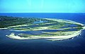
There are state parks in 62 of Pennsylvania's 67 counties,Template:Ref label which nearly reaches Pennsylvania's goal of having a state park within 25 miles (40 km) of every resident in the Commonwealth.<ref name="goddard">{{#invoke:citation/CS1|citation |CitationClass=web }}</ref>Template:Ref label Eleven parks do not have "State Park" in their name. Three are "Conservation Areas": Boyd Big Tree Preserve, Joseph E. Ibberson, and Varden; four are "Environmental Education Centers": Jacobsburg, Jennings, Kings Gap (also a "Training Center") and Nolde Forest; White Clay Creek is a "Preserve"; Norristown is a "Farm Park"; and Big Spring is a "State Forest Picnic Area".<ref name="list">{{#invoke:citation/CS1|citation |CitationClass=web }} Note: this list of all 121 parks is the default reference for current individual Pennsylvania state parks.</ref>
Seven parks are undeveloped with no facilities: Allegheny Islands, Benjamin Rush, Bucktail, Erie Bluffs, Prompton, Swatara, and Varden; the last four of these are in the process of being developed. Five state parks are small picnic areas: Laurel Summit, Patterson, Prouty Place, Sand Bridge, and Upper Pine Bottom. Five state parks have major U.S. Army Corps of Engineers dams and/or lakes: Bald Eagle, Beltzville, Elk, Kettle Creek, and Sinnemahoning. Three former parks now belong, at least partly, to the U.S. Army Corps of Engineers. Seven parks preserve the industrial past: Canoe Creek is the site of a former lime kiln, and Caledonia, French Creek, Greenwood Furnace, Kings Gap, Mont Alto, and Pine Grove Furnace (plus one former park) are all former iron furnace sites.<ref name="list"/><ref name="cupper"/> Eight current parks and one former park contain at least part of eight different National Natural Landmarks.<ref name="nnl">{{#invoke:citation/CS1|citation |CitationClass=web }}</ref>Template:Ref label
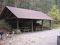
According to the DCNR, the state parks in Pennsylvania are on more than Template:Convert with some 606 full-time and more than 1,600 part-time employees serving approximately 36 million visitors each year. Admission to all Pennsylvania state parks is free, although there are fees charged for use of cabins, marinas, etc. Pennsylvania's state parks offer "over 7,000 family campsites, 286 cabins, nearly 30,000 picnic tables, 56 major recreational lakes, 10 marinas, 61 beaches for swimming, 17 swimming pools" and over 1,000 miles (1,600 km) of trails.<ref name="history">{{#invoke:citation/CS1|citation |CitationClass=web }}</ref>
-
 style }}
 -
 style }}
 -
 style }}
 -
 style }}


History
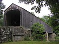
Pennsylvania's first state park was Valley Forge State Park, purchased by the Commonwealth on May 30, 1893, to preserve Valley Forge. It was transferred to the National Park Service (NPS) on the Bicentennial of the United States, July 4, 1976.<ref name="first">{{#invoke:citation/CS1|citation |CitationClass=web }}</ref> Many state parks still preserve history: as of 2012, forty-two Pennsylvania state park sites are on the National Register of Historic Places, including two National Historic Landmarks (Delaware Canal and Point), twenty-eight Civilian Conservation Corps sites in nineteen parks, and twelve other parks' historic sites and districts.<ref name="register">{{#invoke:citation/CS1|citation |CitationClass=web }}</ref> Eight of the former state parks were also chiefly historic.<ref name="cupper"/>
In addition to preserving historic sites, Pennsylvania also sought to preserve natural beauty and offer opportunities for recreation in its state parks. In 1902, Mont Alto State Forest Park was the second park established, a year after the state "Bureau of Forestry" was set up to purchase, preserve, and restore Pennsylvania's forests, which had been ravaged by lumbering, charcoal production, and wild fires. Parks were added sporadically until the 1930s, some mere camping and picnic areas in state forests, while others preserved unique sites.<ref name="early">{{#invoke:citation/CS1|citation |CitationClass=web }}</ref> The 1930s saw a great expansion of parks and their facilities under Governor Gifford Pinchot, who cooperated with President Franklin Roosevelt, despite their being of different political parties. The Civilian Conservation Corps (CCC) established 113 CCC camps in Pennsylvania (second only to California). Using CCC and Works Progress Administration (WPA) labor, the NPS built five Recreation Demonstration Areas, which became Pennsylvania state parks in 1945 and 1946: Blue Knob, French Creek, Hickory Run, Laurel Hill, and Raccoon Creek. The CCC also "fought forest fires, planted trees, built roads, buildings, picnic areas, swimming areas, campgrounds and created many state parks".Template:Ref label<ref name="ccc">{{#invoke:citation/CS1|citation |CitationClass=web }}</ref>
In 1956, there were forty-four state parks in Pennsylvania, mostly in rural areas. Forty-five parks had been added by 1979, mostly near urban areas, and the system had increased by Template:Convert. This was thanks largely to the efforts of Maurice K. Goddard, who served as director of the precursors to the DCNR for twenty-four years under six administrations. The number of visitors to parks more than tripled in this time and two voter approved bond issues (Projects 70 and 500) raised millions of dollars for park expansions and improvements.<ref name="goddard"/> All this expansion was not without costs and by 1988 there was an estimated $90 million in deferred maintenance. In 1993, as the park system celebrated its one-hundredth anniversary, new tax and bond revenues were earmarked for the parks.<ref name="heritage"/> Since 2000, parks are being improved through the state's Growing Greener and Growing Greener II and bond programs.<ref name="gg">{{#invoke:citation/CS1|citation |CitationClass=web }}</ref>
-
 style }}
 -
 style }}
 -
 style }}
 -
style }}


Current parks
.jpg)
Other names of current parks
The following are significantly different former or alternate names for nine current Pennsylvania state parks. Note that many parks were originally "State Forest Parks" or were state public camping or picnic areas in Pennsylvania state forests. In modern times, some "State Parks" have become "Environmental Education Centers", while other parks have dropped one word from their name ("Cherry Springs Drive" is now Cherry Springs, "Codorus Creek" is now Codorus, "Kooser Lake" is now Kooser, "Laurel Hill Summit" is now Laurel Summit, and "Promised Land Lake" is now Promised Land). Such minor name changes are not included in this table.
| Former or alternate Name | County or counties | Date name changed | Current park name | Remarks | |
|---|---|---|---|---|---|
| Adams Falls Class A Campground<ref name="cupper"/> | Westmoreland County | unknown | Linn Run State Park | Adams Falls is a waterfall on Linn Run within Linn Run State Park (which has both an "Adams Falls Picnic Area" and "Adams Falls Trail"). | |
| Halfway State Park<ref>{{#invoke:citation/CS1|citation | CitationClass=web
}}</ref> |
Union County | 1955 | R. B. Winter State Park | Park was renamed for Raymond B. Winter, a Forest Ranger who established it and worked there 45 years; also known as "Halfway Dam State Park". |
| High Rocks State Park<ref>{{#invoke:citation/CS1|citation | CitationClass=web
}}</ref> |
Bucks County | unknown | Ralph Stover State Park | "High Rocks" refers to part of park added in 1956; this name is listed in the USGS GNIS, but was never an official DCNR name or separate park. |
| Pennsylvania State Park at Erie<ref name="heritage"/> | Erie County | unknown | Presque Isle State Park | This was only the second "State Park" by name in the state when established in 1921; also known unofficially as "Peninsula State Park". | |
| Sandy Creek State Park<ref name="cupper"/> | Mercer County | 1969 | Maurice K. Goddard State Park | Proposed as "Sandy Creek" (on Sandy Creek), but the name was changed (despite the objections of Dr. Goddard) before park officially opened in 1972. | |
| Theodore Roosevelt State Park<ref>{{#invoke:citation/CS1|citation | CitationClass=web
}}</ref> |
Bucks and Northampton Counties | 1989 | Delaware Canal State Park | Park was originally named for Theodore Roosevelt, who had no connection to it; renamed for its focus, the Delaware Canal. |
| Tohickon State Park<ref>{{#invoke:citation/CS1|citation | CitationClass=web
}}</ref> |
Bucks County | 1965 | Nockamixon State Park | Park was proposed in 1958 as "Tohickon" (on Tohickon Creek), but the name was changed before the park officially opened in 1973. |
| Whirl's End State Park<ref>{{#invoke:citation/CS1|citation | CitationClass=web
}}</ref> |
Sullivan County | 1936 and 1943 | Worlds End State Park | "Whirl's End" 1936–1943 (for whirlpool in Loyalsock Creek); "Worlds End" 1932–1936 and 1943 to present (for remote location); also known as "Whirl's Glen" |
| Valhalla State Forest Park<ref name="cupper"/> | Potter County | 1920s | Ole Bull State Park | "Valhalla" was a settlement in Ole Bull's failed Norwegian colony, now within the boundaries of Ole Bull State Park. |
-
style }}
-
style }}
-
style }}
-
style }}
Former parks
The following eighteen were once Pennsylvania state parks, but have been transferred to federal (National Park Service, U.S. Army Corps of Engineers) or state (Pennsylvania Historical and Museum Commission, Pennsylvania Game Commission, Pennsylvania Bureau of Forestry) agencies, or ceased to exist.Template:Ref label
| Former state park | County or counties | Date jurisdiction changed | Current name | Remarks | ||
|---|---|---|---|---|---|---|
| Allegheny River State Park<ref name="cupper"/> | Venango County | citation | CitationClass=web
}}</ref> || Kennerdell (or Allegheny River) tract<ref>{{#invoke:citation/CS1|citation |
CitationClass=web
}}Template:Dead linkTemplate:Cbignore</ref> ||Now part of Clear Creek State Forest (Pennsylvania Bureau of Forestry) | ||
| Blue Marsh State Park<ref name="heritage"/><ref name="cupper"/> | Berks County | 1978 | Blue Marsh Lake and Pennsylvania State Game Lands Number 280<ref>{{#invoke:citation/CS1|citation | CitationClass=web
}}</ref><ref>{{#invoke:citation/CS1|citation |
CitationClass=web
}}</ref> ||Park was completed, but without funds to operate it, so was given to the Pennsylvania Game Commission, now also partly a U.S. Army Corps of Engineers site. | |
| Brandywine Battlefield State Park<ref name="cupper"/><ref>{{#invoke:citation/CS1|citation | CitationClass=web
}}</ref> |
Delaware County | unknown | Brandywine Battlefield<ref name = "phmc">{{#invoke:citation/CS1|citation | CitationClass=web
}}</ref> ||Now a Pennsylvania Historical and Museum Commission site | |
| Bushy Run Battlefield State Park<ref name="cupper"/><ref>{{#invoke:citation/CS1|citation | CitationClass=web
}}</ref> |
Westmoreland County | unknown | Bushy Run Battlefield<ref name = "phmc"/> | Now a Pennsylvania Historical and Museum Commission site | |
| Colerain State Park<ref name="cupper"/> | Huntingdon County | unknown | citation | CitationClass=web
}}</ref> ||Now part of Rothrock State Forest (Pennsylvania Bureau of Forestry) although as of 2012 it is not shown on the official state forest web site or map;<ref>{{#invoke:citation/CS1|citation |
CitationClass=web
}}</ref><ref>{{#invoke:citation/CS1|citation |
CitationClass=web
}}</ref> also known historically as "Colerain Forge". |
| Conrad Weiser Memorial Park<ref name="cupper"/> | Berks County | 1953 | Conrad Weiser Homestead<ref name = "phmc"/> | Now a Pennsylvania Historical and Museum Commission site | ||
| Crooked Creek State Park<ref name="heritage"/><ref name="cupper"/><ref>{{#invoke:citation/CS1|citation | CitationClass=web
}}</ref> |
Armstrong County | unknown | Crooked Creek Lake Recreation Area<ref>{{#invoke:citation/CS1|citation | CitationClass=web
}}</ref> ||Now a U.S. Army Corps of Engineers site | |
| Curwensville State Park<ref name="heritage"/><ref name="cupper"/><ref>{{#invoke:citation/CS1|citation | CitationClass=web
}}</ref> |
Clearfield County | unknown | Curwensville Lake on the West Branch Susquehanna River<ref>{{#invoke:citation/CS1|citation | CitationClass=web
}}</ref> ||Now a U.S. Army Corps of Engineers site, recreation area operated by Clearfield County | |
| Drake Well State Park<ref name="cupper"/><ref>{{#invoke:citation/CS1|citation | CitationClass=web
}}</ref> |
Venango County | 1943 | Drake Well Museum<ref name = "phmc"/> | Now a Pennsylvania Historical and Museum Commission site | |
| Fort Necessity State Park<ref name="cupper"/><ref>{{#invoke:citation/CS1|citation | CitationClass=web
}}</ref> |
Fayette County | 1961 | Fort Necessity National Battlefield<ref name = "necessity">{{#invoke:citation/CS1|citation | CitationClass=web
}}</ref> ||Now part of a National Park Service site | |
| George W. Childs State Park<ref name="cupper"/><ref name="early"/><ref>{{#invoke:citation/CS1|citation | CitationClass=web
}}</ref><ref>{{#invoke:citation/CS1|citation |
CitationClass=web
}}</ref> |
Pike County | 1983 | George W. Childs Recreation Site<ref>{{#invoke:citation/CS1|citation | CitationClass=web
}}</ref> ||Now part of Delaware Water Gap National Recreation Area, a National Park Service site; it was donated to the state for a park in 1912 by the widow of Dr. Childs. |
| Hemlock State Forest Park<ref name="central"/> | Perry County | unknown | citation | CitationClass=web
}}</ref> ||Now part of Tuscarora State Forest (Pennsylvania Bureau of Forestry) | ||
| Independence Mall State Park<ref name="cupper"/><ref name="goddard"/><ref>{{#invoke:citation/CS1|citation | CitationClass=web
}}</ref> |
Philadelphia County | 1975 | Independence National Historical Park<ref>{{#invoke:citation/CS1|citation | CitationClass=web
}}</ref> ||Now a National Park Service site | |
| Moosic Lake State Park<ref name="cupper"/> | Lackawanna County | 1930s | No longer in existence | The Pennsylvania state legislature created park in early 1930s, but did not fund it, so it never came into existence. | ||
| Snyder-Middleswarth State Park<ref name="cupper"/><ref>{{#invoke:citation/CS1|citation | CitationClass=web
}}</ref>Template:Ref label |
Snyder County | 1980s | Snyder Middleswarth Natural Area and Picnic Area<ref>{{#invoke:citation/CS1|citation | CitationClass=web
}}</ref><ref name="bald eagle">{{#invoke:citation/CS1|citation |
CitationClass=web
}} Note: shows Snyder Middleswarth Natural Area, Hairy Johns Picnic Area</ref> ||Now part of Bald Eagle State Forest (Pennsylvania Bureau of Forestry), established 1921 |
| Valley Forge State Park<ref name="cupper"/><ref name="first"/> | Montgomery County | 1976 | Valley Forge National Historical Park<ref>{{#invoke:citation/CS1|citation | CitationClass=web
}}</ref> ||Now a National Park Service site, it was established in 1893 as the first state park in Pennsylvania. | ||
| Voneida State Forest Park<ref name="cupper"/><ref>{{#invoke:citation/CS1|citation | CitationClass=web
}}</ref> |
Centre County | unknown | Hairy Johns State Forest Picnic Area<ref name="bald eagle"/> | Now part of Bald Eagle State Forest (Pennsylvania Bureau of Forestry), it was established 1922 and named for "Hairy John" Voneida<ref name="cupper"/><ref name="central">Template:Cite book</ref> |
-
style }}
-
style }}
-
style }}
-
style }}
Other names of former parks
The following are significantly different former or alternate names for two former Pennsylvania state parks. One former park dropped one word from its name ("Colerain Forge" became "Colerain" sometime between 1924 and 1937). Such minor name changes are not included in this table.
| Former or alternate name | County or counties | Date name changed | Former park name | Remarks | |
|---|---|---|---|---|---|
| Braddock Grave State Park<ref>{{#invoke:citation/CS1|citation | CitationClass=web
}}</ref> |
Fayette County | 1961 | Part of Fort Necessity State Park | Now part of Fort Necessity National Battlefield (National Park Service)<ref name = "necessity"/> |
| Hairy John's State Forest Park<ref name="cupper"/> | Centre County | unknown | Voneida State Forest Park | Now a State Forest Picnic Area in Bald Eagle State Forest (Pennsylvania Bureau of Forestry),<ref name="bald eagle"/> it was originally named for "Hairy John" Voneida, a 19th-century hermit who lived nearby. |
See also
Notes
- a. Template:Note labelAs of 2012, three Pennsylvania state parks are also the site of ski areas run by private contractors: Big Pocono (Ski Camelback), Blue Knob (Ski Blue Knob), and Denton Hill (Ski Denton).<ref name="list"/> (Two other state parks had commercial ski operations in the past Laurel Mountain (from 1939 to 2005)<ref>Template:Cite news
</ref> and Black Moshannon (from 1965 to 1982).<ref name="cupper"/><ref>Template:Cite news</ref>) Two parks are operated by other governmental bodies: Hillman (managed for hunting by the Pennsylvania Game Commission) and Norristown Farm (operated by the Montgomery County Department of Parks). Three parks are operated by other organizations: Susquehanna (operated by the Williamsport/Lycoming Chamber of Commerce), Prompton (operated by non-profit "Friends of Prompton"), and Salt Springs (operated by non-profit "Friends of Salt Springs").<ref name="list"/>
- b. Template:Note label The Pennsylvania counties without state parks as of 2023 are: Armstrong, Juniata, Lehigh, Montour, and Snyder counties. Two of these counties are sites of former state parks: Crooked Creek in Armstrong County, and Snyder-Middleswarth in Snyder County.<ref name="list"/><ref name="cupper"/>
- c. Template:Note label The goal of having a state park within 25 miles (40 km) of every resident was set by Maurice K. Goddard (Secretary of the Pennsylvania Department of Forests and Waters, and then of the Department of Environmental Resources from 1955 to 1979).<ref name="goddard"/>
- d. Template:Note label The seven National Natural Landmarks at least partly within current state parks (with the park name in parentheses, if different) are: Cook Forest, Ferncliff Peninsula (Ohiopyle), the Glens Natural Area (Ricketts Glen), Hickory Run Boulder Field (Hickory Run), McConnells Mill, the Pine Creek Gorge (includes Colton Point and Leonard Harrison), and Presque Isle. One National Natural Landmark, Snyder Middleswarth Natural Area, is a former state park.<ref name="nnl"/>
- e. Template:Note label The date of establishment for many Pennsylvania state parks is not always clear, especially for parks developed from state forest property. As an example, consider Upper Pine Bottom, which, as of 2012, is a picnic area surrounded by Tiadaghton State Forest. These state forest lands were acquired by the state by the early 1900s, the site was "Upper Pine Bottom Class B Public Campground" by 1924, the CCC built a pavilion there in 1936 (which is no longer extant), but it was not officially transferred from the Bureau of Forests to State Parks until 1962.<ref name="cupper"/>
- f. Template:Note label This park was one of twenty-five chosen by the Pennsylvania Bureau of Parks for its "25 Must-See Pennsylvania State Parks" list.<ref>{{#invoke:citation/CS1|citation
|CitationClass=web }}</ref>
- g. Template:Note label This park has one or more historic sites or districts on the National Register of Historic Places.<ref name = "register"/>
- h. Template:Note label There have been a considerable number of changes in Pennsylvania's categorization of its state parks and other protected areas over the years, so that what can be called a former state park is not always clear. This can be seen by comparing the following three lists from 1923, 1924, and 1937.
In 1923, the Pennsylvania Department of Forests and Waters listed seven "State Forest Parks": Caledonia, Childs (now part of Delaware Water Gap National Recreation Area), Hairy John's (now a picnic area in Bald Eagle State Forest), James Buchanan, Leonard Harrison, Mont Alto, and Valhalla (now Ole Bull). Note this does not include Snyder-Middleswarth State Forest Park, established in 1921.<ref name="cupper"/>
One year later the state listed twenty-six public campgrounds in state forests, which included three of the previous year's state forest parks, plus twelve sites that later became state parks. The ten Class A Public Campgrounds (with space for cars and tents, on main highways) were: Adams Falls (now Linn Run), Big Spring, Caledonia, Childs, Colerain Forge, Darling Run, Laurel Run Park, Ole Bull, Promised Land, and Tea Springs. The sixteen Class B Public Campgrounds (lean-to shelter, on secondary roads) were: Baldwin, Bear Valley, Cherry Springs Drive, Clear Creek, Donnelly, Joyce Kilmer, Kansas, Kooser, Laurel Hill Summit (now Laurel Summit), Laurel Lake Park, Locusts, McCall's Dam, Ravensburg, Sizerville, Sulphur Springs, and Upper Pine Bottom.<ref name="cupper"/>
In 1937, the state published a brochure listing the following forty-nine protected areas: six State Parks (Caledonia, Childs, Cook Forest, Presque Isle, Pymatuning, and Ralph Stover); eight State Monuments (Bushy Run, Conrad Weiser, Drake Well, Fort Necessity, Fort Washington, James Buchanan, Valley Forge, and Washington Crossing); ten Forest Recreational Reserves (Clear Creek, Colton Point, Cowans Gap, Kooser Lake, Parker Dam, Pecks Pond, Promised Land Lake, Snow Hill, Whipple Dam, Whirl's End); sixteen Wayside Areas (Big Spring, Black Moshannon, Cherry Spring, Colerain, Greenwood Furnace, Halfway (now R.B. Winter), Joyce Kilmer, Kettle Creek, Mont Alto, Pine Grove Furnace, Reeds Gap, S.B. Elliott, Sideling Hill, Sizerville, and Tea Spring); seven Forest Monuments (Alan Seeger, Bear Meadows, Ole Bull, Detweiler Run, McConnell Narrows, Mount Logan, and Snyder-Middleswarth); and three State Forest Lookouts (Leonard Harrison, Martins Hill, and Mount Riansares).<ref>Template:Cite news</ref>
Only twelve of the twenty-six public campgrounds from 1924 are on the 1937 list. Of the forty-nine areas on the 1937 list, twenty-eight are state parks as of 2012, while nine are former state parks, and twelve are in state forests (eight of these still retain their names as state forest picnic, natural or wild areas).
References
External links
Template:US state navigation box Template:Protected areas of Pennsylvania Template:Lists of state parks by U.S. state