List of villages depopulated during the Arab–Israeli conflict
Template:Short description Template:See also Template:Pp-extended Template:More footnotes needed
Below is a list of villages depopulated or destroyed during the Arab–Israeli conflict.
1880–1946
Arab villages
A number of these villages, those in the Jezreel Valley, were inhabited by tenants of land which was sold by a variety of owners, some local and others absentee landlord families, such as the Karkabi, Tueini, Farah and Khuri families and Sursock family of Lebanon. In some cases land was sold directly by local fellahim (peasant owners).<ref name="Verso">Said and Hitchens, 2001, p. 217; notes 28, 29, on p. 232</ref> The sale of land to Jewish organizations meant that tenant farmers were displaced.<ref>Kenneth W. Stein, The Land Question in Palestine, 1917–1939, UNC Press Books, 1987 p.60. The Sursocks sold Jinujar, Tall al-Adas, Jabata, Khuneifis, Jeida, Harbaj, Harithiya, Affula, Shuna, Jidru, Majdal.</ref><ref>Barbara Jean Smith, The Roots of Separatism in Palestine: British Economic Policy, 1920–1929, Syracuse University Press, 1993 pp.96–97;</ref><ref>Mark A. Tessler, A History of the Israeli–Palestinian Conflict, Indiana University Press, 1994 p.177, writes 'The Sursock deal is known to have involved the eviction of about 8000 tenants "compensated" at three pounds ten shillings [about $17] a head.'</ref><ref>Huneidi and Khalidi, 2001, p. 223</ref><ref>Palestine Commission on the Disturbances of August 1929, H.M.S.O., 1930, vol.1 p.437:'The Sursock titles should have been looked into as was acknowledged by the government officials themselves.The transfer became an irregular one, if not an illegal one, because the peasants' claims were not satisfied.'</ref><ref>Henry Laurens, La Question de Palestine, vol.2 (Une mission sacrée de civilisation), Fayard, Paris, 2002 pp.143–148.</ref>
List of Palestinian villages from which tenant farmers were uprooted before 1948, with the cause of the uprooting (i.e., sale by landlord or some other cause) given along with the name of Jewish settlements on newly acquired land (in parentheses) can be seen below.
Template:Col-begin Template:Col-3 Safed district
- al-Mutila, 1896 (Metula) Land, 12,800 dunams, sold under Ottoman law by landlord, a Christian from Sidon named Jabur Bey, to Baron de Rothschild's chief officer Joshua Ossovetski. Druze villagers displaced.<ref>Benny Morris, Righteous Victims. First Vintage 2001 edition, p55.</ref><ref name="Avneri">Avneri, 1984, pp. 96-98</ref>
- Difna, 1939 (Dafna)Template:Citation needed
- al-Manara, unknown date (Manara) 2538 dunams of land purchased by the Jewish National Fund from the landlord, Asa'ad Bey Khuri of Beirut.<ref name=Avneri203>Avneri, 1984, p. 203</ref>
- Najmat as-Subah, unknown date (Ayelet HaShahar)Template:Citation needed
Acre district
- Ja'atoun, unknown date (Ga'aton)Template:Citation needed
- Khirbat Jiddin, 1946, other sources says 1948 (Yehiam)Template:Citation needed
Tiberias district
- Um al-Junah, unknown date (Degania Bet)<ref name=Karmon167>Karmon, 1960, p. 167</ref>
- Malhamiyah, 1902 According to Edward Said, the Jewish farming village of Menahemia) was established in 1902 on land purchased by the Jewish Colonization Association in 1901; 3,000 dunams were purchased directly from local fellahim, 700 dunhams from local landlords, and over 60,000 dunams from landlords in Beirut; the Sursuq, Tuenis, and Mudawwar families. The Arab tenant farmers were evicted by Ottoman authorities.<ref name="Verso"/>
- Sha’arah, beginning of the 20th century (Omer Sha’ara, today Shadmot Dvora)Template:Citation needed
- Sarona, 1910 (Sharona)
- Sarjuna, unknown date (Shorshim, today HaZor'im)Template:Citation needed
- Yammah, 1901 (Yavniel)<ref name=Karmon167/>
Nazareth district
- Jabata, 1926 (Gvat)<ref name=Dayan>Moshe Dayan, cited in Rogan and Shlaim, 2001, p. 207</ref>
- Khunaifis, 1926 (Sarid)<ref name=Dayan/>
- Ganigar, Jinjar, Jenjar, Junjar, 1922, Ginegar,<ref>Grootkerk, 2000, pp. 280-1</ref>
- Rab an-Nasrah, unknown date (Mazra)Template:Citation needed
- Tal al-’Adas, unknown date (Tel Adashim)<ref>Stein, 1987, p. 60</ref>
- al-'Afoulah, 1925 (Afula)
- al-Foulah, 1910 (Merhavia)
- Mashah, 1902 (Kfar Tavor)<ref name=Karmon167/>
- Samouniyah, unknown date (Shimron nature reserve, Timrat)<ref>Karmon, 1960, p. 163</ref>
- Umm Kubei, unknown date<ref name=KhalidiXIX>Khalidi, 1992, p. xix</ref>
Beisan district
- Khirbat Bayt Ilfa, unknown date (Beit Alpha)Template:Citation needed
- Shatah, unknown date (Beit HaShita)
- Tall al-Fir, 1922 (none)Template:Citation needed
- Jaloud, 1922 (Ein Harod)Template:Citation needed
- Zarra'a, Jewish National Fund bought the land in the 1930s, Tirat Tzvi established on the site in 1938<ref>Khalidi, 1992, pp. XIX-XX</ref>
- Jisr Majami<ref name=Census1922a>Barron, 1923, Table IX, Sub-district of Baisan, p. 31</ref><ref name="Census1931">Mills, 1932, p. 79</ref>
Haifa district
- Jadroun, 1925 (Kfar Bialik)Template:Citation needed
- Kurdani, unknown date (Afek)<ref>Pringle, 1997, p. 62</ref>
- Kafr Ata, 1925 (Kfar Ata – today Kiryat Ata)
- al-Majdal, 1925 (none)Template:Citation needed
- al-Harbaj, 1924 (Kfar Hasidim)<ref name=Avneri156>Avneri, 1984, pp. 156-7</ref>
- al-Harithiyah, 1924 (Sha'ar HaAmakim)<ref name=Avneri156/>
- Tab’oun, unknown date (Tivon, today Kiryat Tivon)<ref name=Avneri156/>
- Qusqous, unknown date (Alonim)<ref name=Avneri156/>
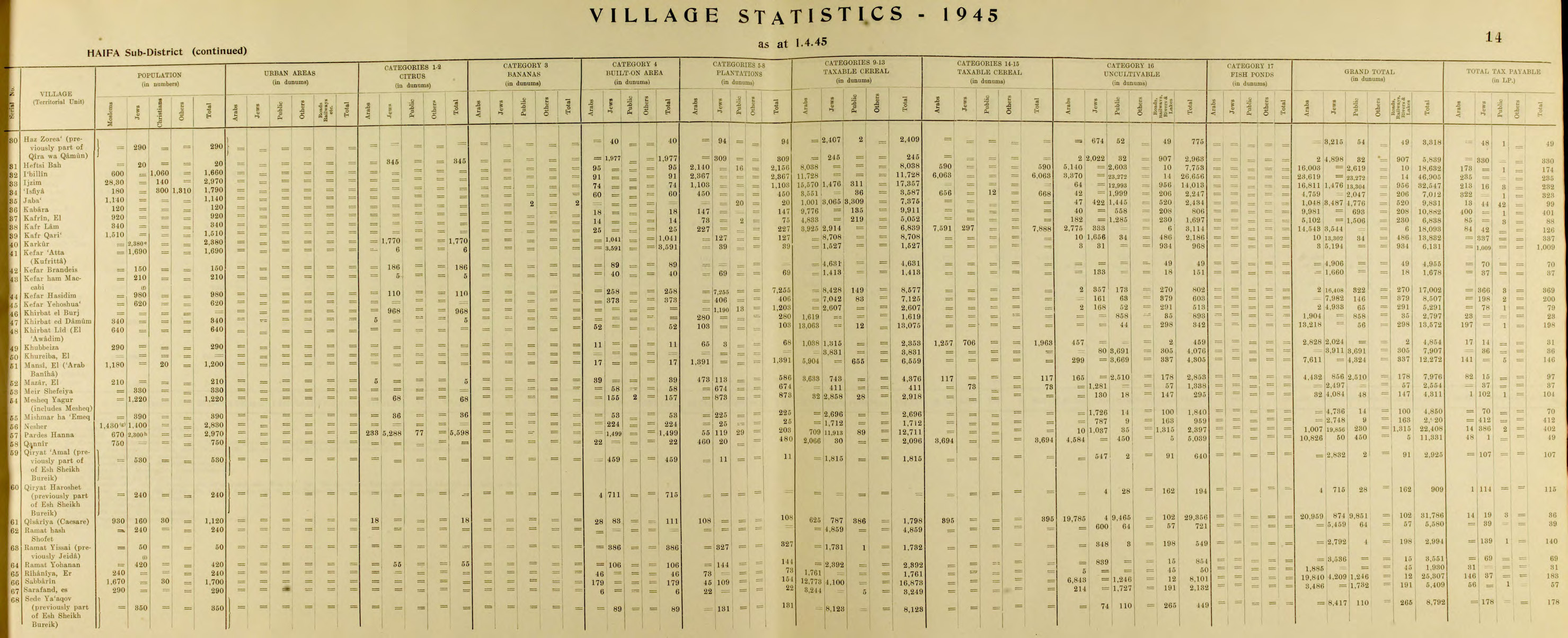
- Jida, 1925 (Ramat Yishai)<ref name=1945p14>Department of Statistics, 1945, p. 14</ref><ref name=Hadawip49>Government of Palestine, Department of Statistics. Village Statistics, April, 1945. Quoted in Hadawi, 1970, p. 49</ref>
- Tal ash-Shamam, 1925 (Kfar Yehoshua)<ref name=Dayan/>
- Qamoun, 1925 (Yokneam)Template:Citation needed
- Ja’ara, unknown date (Ein HaShofet)<ref name=1945p13>Department of Statistics, 1945, p. 13</ref><ref name=Hadawip47>Government of Palestine, Department of Statistics. Village Statistics, April, 1945. Quoted in Hadawi, 1970, p. 47</ref>
- Um ad-Dafouf, unknown date (Dalia)<ref name=Avnerip210>Avneri, 1984, p. 210, note #87, on p. 297</ref><ref name=Khalidip158>Khalidi, 1992, p. 158</ref>
- Um at-Tout, unknown date (none)Template:Citation needed
- Shifiyah, unknown date (Meir Shfeya)<ref>Barron, 1923, Table XI, Sub-district of Haifa, p. 34</ref>
- Zamarin (Zikhron Ya'akov), 1948<ref>Template:Cite journal</ref> – Following Jewish settlement in 1882,<ref>Template:Cite book</ref> Arabs continued to live and work in the community alongside Jews.<ref>Template:Cite book</ref><ref>Template:Cite book</ref><ref>{{#invoke:citation/CS1|citation
|CitationClass=web }}</ref>
- Um al-’Alaq, unknown date, (Ramat HaNadiv)<ref>Sandra Marlene Sufian and Mark LeVine (2007) Reapproaching Borders: New Perspectives on the Study of Israel–Palestine Rowman & Littlefield, Template:ISBN pp. 32</ref>
- ash-Shounah, unknown date (none),Template:Citation needed maybe identical to Khirbat al-Shuna destroyed in 1948
- Zarghaniyah, unknown date (Binyamina)Template:Citation needed
- al-Buraij, unknown date (Binyamina)Template:Citation needed
- Natalah, unknown date (No data)Template:Citation needed
- Nazlah, unknown date (none)Template:Citation needed
- Safsaf, unknown date (none)Template:Citation needed
- Hadidun, unknown date (none)Template:Citation needed
- Karkour, unknown date (Ein Shemer, Gan HaShomron, Karkur, Tel Shalom)Template:Citation needed
- Bidous, unknown date (Maanit)Template:Citation needed
- Shaikh Hilw, unknown date (Nahliel, now part from Hadera)Template:Citation needed
- Zardarah, unknown date (Gan Shmuel)Template:Citation needed
- Baika, unknown date (Hadera)Template:Citation needed
- al-Marah, 1903 (Givat Ada)Template:Citation needed
- ’Aabiyah, 1929 (Pardes Hanna)Template:Citation needed
- Sheikh Bureik Sold during the early 1920s, by the Sursuk family to the Jewish National Fund.<ref name=Avneri122>Avneri, 1984, p. 122</ref> The Arab tenants were evicted and in 1925 an agricultural settlement also named Sheikh Abreik was established there by the Hapoel HaMizrachi, a Zionist political party.<ref>Universal Jewish Encyclopedia, Vol 6, entry "Colonies, Agricultural", p. 287.</ref>
Tulkarm district
- Shaikh Muhammad, unknown date (Elyashiv)
Jerusalem district
Ramla district
- Kafr Wariyah, unknown date (Kfar Uria)<ref name=Kfarim>Template:Cite news</ref>
- Jindas<ref name=KhalidiXIX/> (Ginaton)
Jewish villages
1929 Palestine riots
During the 1929 Palestine riots: Template:Col-begin Template:Col-3
- Bat YamTemplate:Citation needed
- Be'er TuviaTemplate:Citation needed
- Giv'on HaHadashahTemplate:Citation needed
- Hartuv<ref>Kark and Oren-Nordheim, 2001, p.319</ref>
- Kfar UriaTemplate:Citation needed
- Kiryat AtaTemplate:Citation needed
- MotzaTemplate:Citation needed
- Ramat RachelTemplate:Citation needed
- HebronTemplate:Citation needed
1936–1939 Arab revolt in Palestine
During the 1936–1939 Arab revolt in Palestine:
- Kfar ShiloahTemplate:Citation needed
- Silwan Jewish population removed by the Kehillah Welfare Bureau and later the British authorities during the 1936–1939 Arab revolt in Palestine<ref>Sylva M. Gelber, No Balm in Gilead: A Personal Retrospective of Mandate Days in Palestine, Carleton University/McGill University Press 1989 p.88.</ref><ref name="Friedland">Template:Cite book</ref><ref name="Shragai">Template:Cite news</ref><ref>Palestine Post, August 15, 1938, p. 2</ref>
- Kfar EtzionTemplate:Citation needed
- HebronTemplate:Citation needed
1948 Arab–Israeli War
Arab villages
{{#invoke:Labelled list hatnote|labelledList|Main article|Main articles|Main page|Main pages}} Palestinian Arab residents were expelled from hundreds of towns and villages by the Israel Defense Forces, or fled in fear as the Israeli army advanced.Template:Citation needed Around 400 Arab towns and villages were depopulated.
Jewish villages
The main Jewish areas depopulated in 1948 were the Jewish Quarter of the Old City of Jerusalem and the Gush Etzion. Approximately 30–40 km2 of land was owned by Jews in the areas which became the West Bank and Gaza Strip (approximately 6,000 km2); some of this land was uninhabited.<ref>Eyal Benvenisti and Eyal Zamir. “Private Claims to Property Rights in the Future Israeli-Palestinian Settlement” The American Journal of International Law, vol. 89, no. 2, 1995, pp. 298: "All in all, between thirty and forty square kilometers of land and several hundred buildings (primarily in the West Bank) owned by Israelis were located in the territories occupied by Jordan and Egypt. [Footnote: Some of the Jewish-owned lands in these areas were not inhabited, but most were. Some of the inhabitants had been forced to leave their property during the turbulence of the 1920s and 1930s, and most of them (several thousand, mainly from the Jewish quarter of Jerusalem and the Gush Etzion settlements south of Jerusalem) were displaced in the 1948 war. Yet, unlike the Palestinian refugees, these Jewish refugees were rehabilitated and resettled with the help of the Israeli authorities, which prevented the creation of a permanent problem.]"</ref>
- In areas that became the West Bank
- North Jerusalem bloc (Atarot and Neve Yaakov)Template:Citation needed
- Dead Sea block (Kalia and Beit HaArava)Template:Citation needed
- Jewish Quarter (Jerusalem)Template:Citation needed
- Gush Etzion bloc<ref name="History of the Etzion Bloc: The Siege and Fall ">History of the Etzion Bloc: The Siege and Fall Template:Webarchive Page 8 of 11</ref> near Jerusalem (Ein Tzurim, Kfar Etzion, Masuot Yitzhak, Revadim)
- In areas that became Gaza Strip (All-Palestine protectorate)
- Kfar Darom (resettled but evacuated as part of the Israeli disengagement from Gaza in 2005)
- In Transjordan
Many of these areas were repopulated after the Six-Day War.
Six-Day War
West Bank
Three Arab villages, Bayt Nuba, Imwas and Yalo, located in the Latrun Corridor were destroyed on the orders of Yitzhak Rabin due to the corridor's strategic location and route to Jerusalem and because of the residents' alleged aiding of Egyptian commandos in their attack on the city of Lod. The residents of the three villages were offered compensation but were not allowed to return.<ref>Template:Cite book</ref>
Hebron/Bethlehem area<ref name="UN Doc">UN Doc A/8389 Template:Webarchive of 5 October 1971</ref>
Jordan Valley<ref name="UN Doc"/>
- al-Jiftlik (depopulated but soon repopulated)
- Agarith
- Huseirat
Jerusalem area<ref name="UN Doc"/>
In the Negev/Sinai Desert
- Auja al-Hafir – A demilitarized zone
Golan Heights
{{#invoke:Labelled list hatnote|labelledList|Main article|Main articles|Main page|Main pages}} Over 100,000 Golan Heights residents were evacuated from about 25 villages whether on orders of the Syrian government or through fear of an attack by the Israeli Defense Forces and expulsion after the ceasefire.<ref>Report of the Special Committee to Investigate Israeli Practices Affecting the Human Rights of the Population of the Occupied Territories Template:Webarchive (UN Doc A/8089) 5 October 1970</ref> During the following months, more than a hundred Syrian villages were destroyed by Israel.<ref name=shai>"The Fate of Abandoned Arab Villages, 1965–1969" by Aron Shai (History & Memory - Volume 18, Number 2, Fall/Winter 2006, pp. 86–106)</ref>
1979 Egypt–Israel Peace Treaty
Israeli settlements
Israeli settlements in the Sinai Peninsula were evacuated as a result of the 1979 Egypt–Israel peace treaty.
- Avshalom<ref name="Sinai"/>
- Dikla<ref>Gorenberg, Gershom. Accidental Empire, p. 197–198</ref>
- Netiv HaAsara, Sinai<ref name="Sinai"/>
- Ofira<ref>Template:Cite news</ref>
- Pri'el<ref name="Sinai">Template:Cite book</ref>
- Sufa<ref name="Sinai"/>
- Talmei Yosef<ref name="Sinai"/>
- Yamit<ref>Template:Cite news</ref>
Israel's unilateral disengagement plan
As a part of Israel's unilateral disengagement plan, 21 civilian Israeli settlements were forcibly evacuated, as well as an area in the northern West Bank containing four Israeli villages. The residential buildings were razed by Israel but public structures were left intact. The religious structures not removed by Israel were later destroyed by Palestinians.
Israeli settlements
| In the Gaza Strip (all 21 settlements, as well as 1 Bedouin village): | |||
|
|||
| In the West Bank (4 settlements): | |||
Since 2005
On 5 November 2020, Israeli bulldozers demolished most of the village of Khirbet Humsa al-Fawqa and forced 73 of its Palestinian residents, including 41 children to leave in what was the largest demolition in years.<ref>Israel demolishes most of Palestinian Bedouin village in West Bank 5 November 2020 www.abc.net.au accessed 18 April 2021</ref> On 4 February 2021, Israel razed for the second time because of what it claimed was an illegal settlement next to a military firing range.<ref>Israel begins razing Palestinian Bedouin village for second time 4 February 2021 www.nbc.com accessed 18 April 2021</ref> On 7 July 2021, it was demolished by Israel again for at least the third time.<ref>Israel again tears down contested Palestinian hamlet in Jordan Valley 7 July 2021 www.timesofisrael.com accessed 14 July 2021</ref>
In May 2023, the Israeli army destroyed the village of Ein Samiya, forcibly expelling 170 people.<ref>{{#invoke:citation/CS1|citation |CitationClass=web }}</ref>
See also
- Killings and massacres during the 1948 Palestine War
- Transfer Committee
- 1948 Palestinian expulsion and flight
References
Bibliography
- Template:Cite book
- Template:Cite book
- Template:Cite book
- Template:Cite book
- Template:Cite book
- Template:Cite book
- Template:Cite book
- Template:Cite journal
- Template:Cite book
- Template:Cite book
- Template:Cite book
- Template:Cite book
External links
Template:Palestinian Arab villages depopulated during the 1948 Palestine War Template:Jewish villages depopulated during the 1948 Palestine war Template:Arab-Israeli Conflict