Mount Mitchell (Queensland)
Template:Short description Template:Use Australian English Template:Use dmy dates Template:Infobox mountain Mount Mitchell (Aboriginal: Cooyinnirra<ref name="amr">{{#invoke:citation/CS1|citation |CitationClass=web }}</ref>), is a twin-peaked volcanic mountain with an elevation above sea level of Template:Convert,<ref>Template:Cite book</ref> located in the Main Range, is about Template:Convert west of Brisbane, Queensland, Australia and immediately south of Cunninghams Gap.
Features and history
The peak to the south of the gap was named by Allan Cunningham in 1828 and today is part of the Main Range National Park. Cunningham named the mountain after the Surveyor-General, Thomas Mitchell.<ref name="nch">{{#invoke:citation/CS1|citation |CitationClass=web }}</ref>
To the north of Cunninghams Gap is Mount Cordeaux, while Spicers Peak is located a small distance to the south east.
A trail, classified as grade 4,<ref>{{#invoke:citation/CS1|citation |CitationClass=web }}</ref> winds Template:Convert up to the main summit which offers some great views. From the peak on a clear day the tallest buildings in Brisbane can be seen, as can the D'Aguilar Range, Teviot Range, Fassifern Valley and many other parts of the Scenic Rim. At the top of mountain there are sheer cliff edges.
Gallery
-
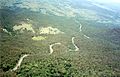 Cunningham Highway viewed from the top of Mount Mitchell.
 -
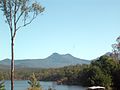 View from Lake Moogerah, 2011.

