North Gyeongsang Province
Template:Short description Template:Use dmy dates Template:Main other{{#invoke:Infobox|infobox}}Template:Template other{{#invoke:Check for unknown parameters|check|unknown=Template:Main other|preview = Page using [[Template:Template:If empty]] with unknown parameter "_VALUE_"|ignoreblank=y|mapframe_args=y | alt | anthem | anthem_link | area_blank1_acre | area_blank1_dunam | area_blank1_ha | area_blank1_km2 | area_blank1_sq_mi | area_blank1_title | area_blank2_acre | area_blank2_dunam | area_blank2_ha | area_blank2_km2 | area_blank2_sq_mi | area_blank2_title | area_code | area_code_type | area_codes | area_footnotes | area_land_acre | area_land_dunam | area_land_ha | area_land_km2 | area_land_sq_mi | area_metro_acre | area_metro_dunam | area_metro_footnotes | area_metro_ha | area_metro_km2 | area_metro_sq_mi | area_note | area_rank | area_rural_acre | area_rural_dunam | area_rural_footnotes | area_rural_ha | area_rural_km2 | area_rural_sq_mi | area_total_acre | area_total_dunam | area_total_ha | area_total_km2 | area_total_sq_mi | area_urban_acre | area_urban_dunam | area_urban_footnotes | area_urban_ha | area_urban_km2 | area_urban_sq_mi | area_water_acre | area_water_dunam | area_water_ha | area_water_km2 | area_water_percent | area_water_sq_mi | blank_emblem_alt | blank_emblem_link | blank_emblem_size | blank_emblem_type | blank_emblem_sizedefault | blank_emblem_upright | blank_info | blank_info_sec1 | blank_info_sec2 | blank_name | blank_name_sec1 | blank_name_sec2 | blank1_info | blank1_info_sec1 | blank1_info_sec2 | blank1_name | blank1_name_sec1 | blank1_name_sec2 | blank2_info | blank2_info_sec1 | blank2_info_sec2 | blank2_name | blank2_name_sec1 | blank2_name_sec2 | blank3_info | blank3_info_sec1 | blank3_info_sec2 | blank3_name | blank3_name_sec1 | blank3_name_sec2 | blank4_info | blank4_info_sec1 | blank4_info_sec2 | blank4_name | blank4_name_sec1 | blank4_name_sec2 | blank5_info | blank5_info_sec1 | blank5_info_sec2 | blank5_name | blank5_name_sec1 | blank5_name_sec2 | blank6_info | blank6_info_sec1 | blank6_info_sec2 | blank6_name | blank6_name_sec1 | blank6_name_sec2 | blank7_info | blank7_info_sec1 | blank7_info_sec2 | blank7_name | blank7_name_sec1 | blank7_name_sec2 | caption | code1_info | code1_name | code2_info | code2_name | coor_pinpoint | coor_type | coordinates | coordinates_footnotes | demographics_type1 | demographics_type2 | demographics1_footnotes | demographics1_info1 | demographics1_info10 | demographics1_info2 | demographics1_info3 | demographics1_info4 | demographics1_info5 | demographics1_info6 | demographics1_info7 | demographics1_info8 | demographics1_info9 | demographics1_title1 | demographics1_title10 | demographics1_title2 | demographics1_title3 | demographics1_title4 | demographics1_title5 | demographics1_title6 | demographics1_title7 | demographics1_title8 | demographics1_title9 | demographics2_footnotes | demographics2_info1 | demographics2_info10 | demographics2_info2 | demographics2_info3 | demographics2_info4 | demographics2_info5 | demographics2_info6 | demographics2_info7 | demographics2_info8 | demographics2_info9 | demographics2_title1 | demographics2_title10 | demographics2_title2 | demographics2_title3 | demographics2_title4 | demographics2_title5 | demographics2_title6 | demographics2_title7 | demographics2_title8 | demographics2_title9 | dimensions_footnotes | dunam_link | elevation_footnotes | elevation_ft | elevation_link | elevation_m | elevation_max_footnotes | elevation_max_ft | elevation_max_m | elevation_max_point | elevation_max_rank | elevation_min_footnotes | elevation_min_ft | elevation_min_m | elevation_min_point | elevation_min_rank | elevation_point | embed | established_date | established_date1 | established_date2 | established_date3 | established_date4 | established_date5 | established_date6 | established_date7 | established_title | established_title1 | established_title2 | established_title3 | established_title4 | established_title5 | established_title6 | established_title7 | etymology | extinct_date | extinct_title | flag_alt | flag_border | flag_link | flag_size | footnotes | founder | geocode | governing_body | government_footnotes | government_type | government_blank1_title | government_blank1 | government_blank2_title | government_blank2 | government_blank2_title | government_blank3 | government_blank3_title | government_blank3 | government_blank4_title | government_blank4 | government_blank5_title | government_blank5 | government_blank6_title | government_blank6 | grid_name | grid_position | image_alt | image_blank_emblem | image_caption | image_flag | image_map | image_map1 | image_seal | image_shield | image_size | image_skyline | imagesize | image_sizedefault | image_upright | iso_code | leader_name | leader_name1 | leader_name2 | leader_name3 | leader_name4 | leader_name5 | leader_party | leader_title | leader_title1 | leader_title2 | leader_title3 | leader_title4 | leader_title5 | length_km | length_mi | map_alt | map_alt1 | map_caption | map_caption1 | mapsize | mapsize1 | module | motto | motto_link | mottoes | name | named_for | native_name | native_name_lang | nickname | nickname_link | nicknames | official_name | other_name | p1 | p10 | p11 | p12 | p13 | p14 | p15 | p16 | p17 | p18 | p19 | p2 | p20 | p21 | p22 | p23 | p24 | p25 | p26 | p27 | p28 | p29 | p3 | p30 | p31 | p32 | p33 | p34 | p35 | p36 | p37 | p38 | p39 | p4 | p40 | p41 | p42 | p43 | p44 | p45 | p46 | p47 | p48 | p49 | p5 | p50 | p6 | p7 | p8 | p9 | parts | parts_style | parts_type | pop_est_as_of | pop_est_footnotes | population | population_as_of | population_blank1 | population_blank1_footnotes | population_blank1_title | population_blank2 | population_blank2_footnotes | population_blank2_title | population_demonym | population_demonyms | population_density_blank1_km2 | population_density_blank1_sq_mi | population_density_blank2_km2 | population_density_blank2_sq_mi | population_density_km2 | population_density_metro_km2 | population_density_metro_sq_mi | population_density_rank | population_density_rural_km2 | population_density_rural_sq_mi | population_density_sq_mi | population_density_urban_km2 | population_density_urban_sq_mi | population_est | population_footnotes | population_metro | population_metro_footnotes | population_note | population_rank | population_rural | population_rural_footnotes | population_total | population_urban | population_urban_footnotes | postal_code | postal_code_type | postal2_code | postal2_code_type | pushpin_image | pushpin_label | pushpin_label_position | pushpin_map | pushpin_map_alt | pushpin_map_caption | pushpin_map_caption_notsmall | pushpin_map_narrow | pushpin_mapsize | pushpin_outside | pushpin_overlay | pushpin_relief | registration_plate | registration_plate_type | seal_alt | seal_link | seal_size | seal_type | seat | seat_type | seat1 | seat1_type | seat2 | seat2_type | settlement_type | shield_alt | shield_link | shield_size | short_description | subdivision_name | subdivision_name1 | subdivision_name2 | subdivision_name3 | subdivision_name4 | subdivision_name5 | subdivision_name6 | subdivision_type | subdivision_type1 | subdivision_type2 | subdivision_type3 | subdivision_type4 | subdivision_type5 | subdivision_type6 | template_name | timezone | timezone_DST | timezone_link | timezone1 | timezone1_DST | timezone1_location | timezone2 | timezone2_DST | timezone2_location | timezone3 | timezone3_DST | timezone3_location | timezone4 | timezone4_DST | timezone4_location | timezone5 | timezone5_DST | timezone5_location | total_type | translit_lang1 | translit_lang1_info | translit_lang1_info1 | translit_lang1_info2 | translit_lang1_info3 | translit_lang1_info4 | translit_lang1_info5 | translit_lang1_info6 | translit_lang1_type | translit_lang1_type1 | translit_lang1_type2 | translit_lang1_type3 | translit_lang1_type4 | translit_lang1_type5 | translit_lang1_type6 | translit_lang2 | translit_lang2_info | translit_lang2_info1 | translit_lang2_info2 | translit_lang2_info3 | translit_lang2_info4 | translit_lang2_info5 | translit_lang2_info6 | translit_lang2_type | translit_lang2_type1 | translit_lang2_type2 | translit_lang2_type3 | translit_lang2_type4 | translit_lang2_type5 | translit_lang2_type6 | type | unit_pref | utc_offset | utc_offset_DST | utc_offset1 | utc_offset1_DST | utc_offset2 | utc_offset2_DST | utc_offset3 | utc_offset3_DST | utc_offset4 | utc_offset4_DST | utc_offset5 | utc_offset5_DST | website | width_km | width_mi }}{{#invoke:Check for clobbered parameters|check | template = [[Template:Template:If empty]] | cat = Template:Main other | population; population_total | image_size; imagesize | image_alt; alt | image_caption; caption | settlement_type; type | utc_offset1; utc_offset | timezone1; timezone }}{{#if:
|
}}Template:Main other{{#ifexpr:{{#invoke:ParameterCount|main|mapframe|image_map|image_map1|pushpin_map}} >2 |Template:Main other}} North Gyeongsang Province (Template:Korean, {{#invoke:IPA|main}}) is a province in eastern South Korea, and with an area of Template:Convert, it is the largest province in the Korean peninsula. The province was formed in 1896 from the northern half of the former Gyeongsang province, and remained a province of Korea (as Keishōhoku-dō during Japanese rule) until the country's division in 1945, then became part of South Korea.
Daegu was the capital of North Gyeongsang Province between 1896 and 1981, but has not been a part of the province since 1981. In 2016, the provincial capital moved from Daegu to Andong.<ref>{{#invoke:citation/CS1|citation |CitationClass=web }}</ref>
History
Template:See also The 1,000-year-old Silla Kingdom flourished and unified the previous three kingdoms. The area was named Gyeongsang-do in 1314 during the Goryeo Dynasty. In 1896, during the Joseon Dynasty, the area was renamed Gyeongsangbuk-do as 13 roads were reorganized. The current administrative district was reorganized with the reorganization of Bu, Gun, and Myeon in 1914.<ref>{{#invoke:citation/CS1|citation |CitationClass=web }}</ref>
Geography and climate
The province is part of the Yeongnam region, bordered to the south by South Gyeongsang Province, to the west by North Jeolla and North Chungcheong Provinces, and to the north by Gangwon Province. It is largely surrounded by mountains: the Taebaek Mountains in the east and the Sobaek Mountains in the west.Template:Citation needed The province also contains the island of Ulleungdo, the seventh largest island in South Korea, located in the Sea of Japan.<ref>{{#invoke:citation/CS1|citation |CitationClass=web }}</ref>
Culture
Cuisine
Andong Sikhye, a local food from Andong and northern North Gyeongsang Province, is essential for entertaining guests on Seollal or feast days. Unlike ordinary Sikhye, it is red with Chili powder, has more grains of rice, and less soup.<ref>{{#invoke:citation/CS1|citation |CitationClass=web }}</ref>
Tourism
North Gyeongsang Province is the homeland of the former kingdom of Silla and has retained much of its cultural tradition. A number of artists, political leaders and scholars have come from the province.
-
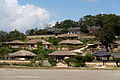
 View of Hahoe Folk Village in Andong
 -
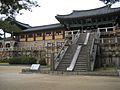
 View of Yangdong Folk Village in Gyeongju
 -

-


.jpg)
Demographics
Template:Historical populations
Cities, towns, and villages
Religion
According to the census of 2015, 25.3% followed Buddhism and 18.5% followed Christianity (13.3% Protestantism and 5.2% Catholicism). 55.4% of the population is irreligious.<ref name="2015census">{{#invoke:citation/CS1|citation |CitationClass=web }}</ref>
Administrative divisions
Gyeongsangbuk-do is divided into 10 cities (si) and 12 counties (gun). The names below are given in English, hangul, and hanja. Gyeongsang do is originated from Gyeongju & Sangju old city of Gyeong+Sang from Joseon Dynasty (1392–1910). Do means road to 8 directional road from Seoul. Pohang is Korean steel production hub, Gumi is electronics capital of South Korea.

| Map | # | Name | Hangul | Hanja | citation | CitationClass=web
}}</ref> |
Subdivisions |
|---|---|---|---|---|---|---|---|

| |||||||
| — Specific City — | |||||||
| 1 | Pohang | Template:Nowrap | Template:Nowrap | 492,041 | 2 ilban-gu — 4 eup, 10 myeon, 15 haengjeong-dong | ||
| — City — | |||||||
| 2 | Gumi | lang}} | lang}} | 404,691 | 2 eup, 6 myeon, 19 haengjeong-dong | ||
| 3 | Gyeongsan | lang}} | lang}} | 266,951 | 2 eup, 6 myeon, 7 haengjeong-dong | ||
| 4 | Gyeongju | lang}} | lang}} | 245,365 | 4 eup, 8 myeon, 11 haengjeong-dong | ||
| 5 | Andong | lang}} | lang}} | 153,348 | 1 eup, 13 myeon, 10 haengjeong-dong | ||
| 6 | Gimcheon | lang}} | lang}} | 135,767 | 1 eup, 14 myeon, 7 haengjeong-dong | ||
| 7 | Yeongju | lang}} | lang}} | 99,309 | 1 eup, 9 myeon, 9 haengjeong-dong | ||
| 8 | Sangju | lang}} | lang}} | 92,452 | 1 eup, 17 myeon, 6 haengjeong-dong | ||
| 9 | Yeongcheon | lang}} | lang}} | 99,034 | 1 eup, 10 myeon, 5 haengjeong-dong | ||
| 10 | Mungyeong | lang}} | lang}} | 67,544 | 2 eup, 7 myeon, 5 haengjeong-dong | ||
| — County — | |||||||
| 11 | Chilgok County | lang}} | lang}} | 108,119 | 3 eup, 5 myeon | ||
| 12 | Uiseong County | lang}} | lang}} | 56,777 | 1 eup, 17 myeon | ||
| 13 | Uljin County | lang}} | lang}} | 46,112 | 2 eup, 8 myeon | ||
| 14 | Yecheon County | lang}} | lang}} | 45,948 | 1 eup, 11 myeon | ||
| 15 | Cheongdo County | lang}} | lang}} | 43,787 | 2 eup, 7 myeon | ||
| 16 | Seongju County | lang}} | lang}} | 44,824 | 1 eup, 9 myeon | ||
| 17 | Yeongdeok County | lang}} | lang}} | 40,213 | 1 eup, 8 myeon | ||
| 18 | Goryeong County | lang}} | lang}} | 35,281 | 1 eup, 7 myeon | ||
| 19 | Bonghwa County | lang}} | lang}} | 33,936 | 1 eup, 9 myeon | ||
| 20 | Cheongsong County | lang}} | lang}} | 26,432 | 1 eup, 7 myeon | ||
| 21 | Yeongyang County | lang}} | lang}} | 18,259 | 1 eup, 5 myeon | ||
| 22 | Ulleung County | lang}} | lang}} | 10,557 | 1 eup, 2 myeon | ||
Economy
In October 2022, the province announced its plan to make the province a leading area centered on the domestic metaverse. It is also a specialized complex for semiconductor and secondary battery national high-tech strategic industries.<ref>Template:Cite news</ref>
Industry
The service industry accounts for 58.3%, mining manufacturing industry account for 30.6%, construction account for 10.5%, and agriculture and fishing account for 0.6%. Mobile convergence, digital device parts, and energy material parts are major specialized industries.<ref name=":0">{{#invoke:citation/CS1|citation |CitationClass=web }}</ref>
Transportation
Airports
The province is served by these airports:
Railway

The railway stations in North Gyeongsang Province are as follows: Template:Div col
- Andong station
- Apo station
- Bonghwa station
- Cheongdo station
- Daesin station
- Gimcheon station
- Gimcheon (Gumi) station
- Gumi station
- Gyeongju station
- Gyeongsan station
- Hwabon station
- Jeomchon Station
- Jicheon station
- Jikjisa station
- Jinyeong station
- Moryang station
- Mungyeong station
- Munsu station
- Namseonghyeon station
- Pohang station
- Punggi station
- Sagok station
- Samseong station
- Sinam station
- Sindong station
- Singeo station
- Uiseong station
- Waegwan station
- Yangmok station
- Yeongcheon station
- Yeongdeok station
- Yeongju station
- Yeonhwa station
Recent discoveries
In September 2021, archaeologists announced the discovery of 1500 years-old woman skeleton with a necklace and a bracelet in North Gyeongsang Province. The remains of a 135-centimeter-tall woman, who is estimated to have died in her 20s, were discovered along with the bones of animals such as horses and cows, as well as earthenware.<ref>{{#invoke:citation/CS1|citation |CitationClass=web }}</ref><ref>{{#invoke:citation/CS1|citation |CitationClass=web }}</ref><ref>{{#invoke:citation/CS1|citation |CitationClass=web }}</ref><ref>{{#invoke:citation/CS1|citation |CitationClass=web }}</ref>
Notable people from North Gyeongsang Province
- Lee Myung-bak, Former President of South Korea
- Han Duck-soo, Former Prime minister of South Korea
- Cho Tae-yul, 41st Foreign Minister of South Korea
- Taeyeon (born Kim Tae-yeon 1989), singer and member of Girls' Generation
- Kwon Yong-jin, South Korean politician
- Kim Boo-kyum, South Korean politician
- Park Chung Hee, Former South Korean President
- Ahn Ji-young, a member of Korean band Bolbbalgan4
- Yoo Jae-ha, South Korean singer and songwriter
See also
References
External links
- {{#invoke:URL|url}}{{#invoke:Check for unknown parameters|check|unknown=Template:Main other|preview=Page using Template:URL with unknown parameter "_VALUE_"|ignoreblank=y | 1 | 2 }} Template:In lang
- Template:In lang Alsace/Gyeongsangbuk-do
- Template:Wikivoyage inline
Template:Geographic location Template:North Gyeongsang {{#invoke:Navbox|navbox}}