Patterson railway station
Template:Short description Template:Not to be confused with Template:Use dmy dates Template:Use Australian English Template:Infobox station
Patterson railway station is a commuter railway station on the Frankston line, which is part of the Melbourne railway network. It serves the south-eastern suburb of Bentleigh, in Melbourne, Victoria, Australia. Patterson station is a ground level unstaffed station, featuring three platforms, an island platform with two faces and one side platform. It opened on 28 May 1961, with the current station provided in 1987.<ref name="theage1">Template:Cite news</ref>
While the station had been proposed in 1930s<ref>Template:Cite news</ref><ref>Template:Cite news</ref><ref>Template:Cite news</ref> demands from local residents intensified throughout the 1950s.<ref>Template:Cite news</ref>
Named after Patterson Road, which is located immediately south of the station and also provides access, construction of the station commenced in 1958.<ref name="divisionaldiarymar58">Template:Cite magazine</ref> An island platform was provided, and provision made for another platform face on the eastern side of the station. A photo taken by Weston Langford(1941-2014) on the day prior to the official opening clearly shows the new "middle" line about to be connected (see below), and the easternmost line removed shortly afterwards. There was also a signal box located at the eastern side (down line) that has since been removed. On 28 June 1987, a third track was provided between Caulfield and Moorabbin, and platform 3 was constructed on the eastern side.<ref name="newsrailsep87">Template:Cite magazine</ref>
On 17 December 1994, a deliberately lit fire damaged parts of the station.<ref name="theage2">Template:Cite news</ref><ref name="heraldsun">Template:Cite news</ref>
Platforms and services
Patterson has one island platform with two faces and one side platform. It is serviced by Metro Trains' Frankston line services.<ref>Template:Cite PTV route</ref>
Current
| colspan="6" style="background:#Template:Rcr;background-image: linear-gradient(to right, #Template:Rcr); " |Patterson platform arrangement | |||||
|---|---|---|---|---|---|
| Platform | Line | Destination | Via | Service Type | Notes |
| 1 | Template:RouteBox | Flinders Street, Werribee, Williamstown | Flinders Street | All stations and limited express services | |
| 2 | Template:RouteBox | Services may occasionally stop at this platform. Peak hour services run express through this station. | |||
| 3 | Template:RouteBox | Frankston | All stations |
From 1 February 2026
| colspan="6" style="background:#Template:Rcr;background-image: linear-gradient(to right, #Template:Rcr); " |Patterson platform arrangement | |||||
|---|---|---|---|---|---|
| Platform | Line | Destination | Via | Service Type | Notes |
| 1 | Template:RouteBox | Flinders Street | City Loop | All stations and limited express services | |
| 2 | Template:RouteBox | Services may occasionally stop at this platform. Peak hour services run express through this station. | |||
| 3 | Template:RouteBox | Frankston | All stations |
Art installation
In 2011, Pamela Irving curated a mosaic installation named Stationary Faces, consisting of a collage of various mosaic portraits. This project was funded by government department Arts Victoria (now Creative Victoria) and VicTrack, and was developed in collaboration with an estimate of 750 school students and youth services from Australia and abroad, inspired by Irving's mosaic works.<ref name="blogIrving">{{#invoke:citation/CS1|citation |CitationClass=web }}</ref>
Stationary Faces was proposed by Irving in order to combat constant vandalism in the station's underpass, with the assistance of Rob Hudson, the Victorian parliament member for Bentleigh at the time. Irving's aims with the project were two-fold; to contribute to a "cultural sprawl" alongside the city of Melbourne's urban sprawl,<ref name="smhIrving">{{#invoke:citation/CS1|citation |CitationClass=web }}</ref> and to use recycled/donated tiles and ceramics for environmental sustainability.
Gallery
-
 Southbound view from Platform 3, June 2014
 -
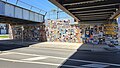 Art installation under the staton's rail corridor bridge
.jpg)

References
External links
- Melway map at street-directory.com.au