Pecos River
Template:Short description Template:Infobox river The Pecos River (Template:IPAc-en Template:Respell;<ref>{{#invoke:citation/CS1|citation |CitationClass=web }}</ref> Template:Langx) originates in north-central New Mexico and flows into Texas, emptying into the Rio Grande. Its headwaters are on the eastern slope of the Sangre de Cristo mountain range in Mora County north of Pecos, New Mexico, at an elevation of over 12,000 feet (3,700 m).<ref>{{#invoke:citation/CS1|citation |CitationClass=web }}</ref> The river flows for 926 miles (1,490 km) before reaching the Rio Grande near Del Rio. Its drainage basin encompasses about 44,300 square miles (115,000 km2).<ref name=largest>Largest Rivers of the United States, USGS</ref>
The name "Pecos" derives from the Keresan (Native American language) term for the Pecos Pueblo, [p'æyok'ona].<ref name="Bright2004">Template:Cite book</ref> The river was also historically referred to as the Río Natagés for the Mescalero people.<ref>{{#invoke:citation/CS1|citation |CitationClass=web }}</ref>
History
The river was the eastern territory of the Faraon (‘Pharaoh’) Apache Indians, a tribe of Apache, probably closely related to the Mescalero Apache, if not part of them. Their divisions were Ancavistis, Jacomis, Orejones, Carlanes, and Cuampes, but of these the Carlanes at least belonged to the Jicarillas. The river later played a large role in the exploration of Texas by the Spanish. In the latter half of the 19th century, "West of the Pecos" was a reference to the rugged desolation of the Wild West. New Mexico and Texas disputed water rights to the river until the U.S. government settled the dispute in 1949 with the Pecos River Compact.<ref>{{#invoke:citation/CS1|citation |CitationClass=web }}</ref> The Pecos River Settlement Agreement was signed between New Mexico and Texas in 2003.<ref>Pecos River Settlement Agreement </ref>
Dams
Multiple dams have been built along the Pecos River. Santa Rosa Lake is 117 miles/188 km east of Albuquerque.<ref>{{#invoke:citation/CS1|citation |CitationClass=web }}</ref> Sumner Lake, formed by the 1939 Sumner Dam, is located between Santa Rosa and Fort Sumner, New Mexico.<ref>{{#invoke:citation/CS1|citation |CitationClass=web }}</ref> Two dams are located north of Carlsbad, New Mexico, at Avalon Dam and Brantley Dam, to help irrigate about Template:Convert as part of the Carlsbad reclamation project (established in 1906). Texas has also dammed the river at the Red Bluff Dam in the western part of that state to form the Red Bluff Reservoir. The portion of the reservoir that extends into New Mexico forms the lowest point in that state.
Wild and Scenic river
On June 6, 1990, Template:Convert of the Pecos River—from its headwaters to the townsite of Tererro—received National Wild and Scenic River designation. It includes Template:Convert designated "wild" and Template:Convert designated "recreational".<ref>Pecos Wild and Scenic River, New Mexico Template:Webarchive - National Wild and Scenic Rivers System</ref>
-
 Pecos River between Terrerro and Pecos, New Mexico
 -
 The Pecos River flowing south of Grandfalls, Texas
 -
 Pecos River near the Rio Grande
 -
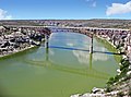 Pecos River Highway Bridge


Pecos River Flume

The Pecos River Flume is an aqueduct carrying irrigation water over the Pecos River. Construction took place from 1889 to 1890 and was part of the Pecos River Reclamation Project. It was originally constructed of wood and spanned Template:Convert. It carried water at a depth of Template:Convert. In 1902, a flood destroyed the flume and it was subsequently rebuilt using concrete. In 1902, it was identified as the largest concrete aqueduct in the world.<ref name="ArchulettaHolden2003">Template:Cite book</ref><ref name="Institute2002">Template:Cite book</ref>
The flume and its surrounding area have been reclaimed by the city of Carlsbad and transformed into a tourist attraction, with park improvements along the river and spotlights to give a spectacular nightly view.
See also
- List of longest rivers of the United States (by main stem)
- List of tributaries of the Rio Grande
- List of rivers of New Mexico
- List of rivers of Texas
References
External links
- Pecos River
- Rivers of New Mexico
- Rivers of Texas
- Tributaries of the Rio Grande
- Wild and Scenic Rivers of the United States
- Rivers of Eddy County, New Mexico
- Rivers of San Miguel County, New Mexico
- Bodies of water of Ward County, Texas
- Rivers of Val Verde County, Texas
- Bodies of water of Loving County, Texas
- Bodies of water of Reeves County, Texas
- Bodies of water of Pecos County, Texas
- Bodies of water of Crane County, Texas
- Bodies of water of Crockett County, Texas
- Bodies of water of Terrell County, Texas
- Pecos, Texas