Polillo Islands
Template:Short description Template:Distinguish Template:Infobox islands
The Polillo Islands is a group of about 27 islands in the Philippine Sea lying about Template:Convert to the east of the Philippine island of Luzon. It is separated from the mainland Luzon Island by the Polillo Strait and forms the northern side of Lamon Bay. The islands are part of the province of Quezon in the Calabarzon region of the Philippines.<ref name="pol">{{#invoke:citation/CS1|citation |CitationClass=web }}</ref><ref name="bl">{{#invoke:citation/CS1|citation |CitationClass=web }}</ref> The combined land area of all the islands is about 875 square kilometers making Polillo islands even larger than the island city-state of Singapore.
Major islands
The three major islands are:
- Polillo Island
- Patnanungan Island
- Jomalig Island
These islands comprise the towns of Polillo, Patnanungan, Jomalig, Panukulan and Burdeos.
The biggest Polillo Island is divided into three municipalities of Polillo, Burdeos, and Panukulan.
Burdeos Bay lies in between the islands of Patnanungan and Polillo
Polillo also includes the privately owned resort island of Balesin, located further south in the middle of Lamon Bay.
- Polillo (southern part of Polillo Island, including Balesin Island)
- Burdeos (northeastern part of Polillo Island, including smaller islands like Palasan, Kalotkot, and Kalongkooan)
- Panukulan (northwestern part of Polillo Island)
- Patnanungan (middle island)
- Jomalig (easternmost island)
Gallery
-
 Kanaway beach in Jomalig
 -
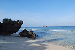
 A beach in southeastern Jomalig
 -
 Lingayen Cove in Jomalig
 -
 A beach in Balesin
 -
Themed accommodations at the Balesin Island Club
-
Resort grounds in Balesin


References
External links
Template:Geographic location
Template:Quezon
Template:Authority control