Samzhubzê, Xigazê
Template:Main other{{#invoke:Infobox|infobox}}Template:Template other{{#invoke:Check for unknown parameters|check|unknown=Template:Main other|preview = Page using [[Template:Template:If empty]] with unknown parameter "_VALUE_"|ignoreblank=y|mapframe_args=y | alt | anthem | anthem_link | area_blank1_acre | area_blank1_dunam | area_blank1_ha | area_blank1_km2 | area_blank1_sq_mi | area_blank1_title | area_blank2_acre | area_blank2_dunam | area_blank2_ha | area_blank2_km2 | area_blank2_sq_mi | area_blank2_title | area_code | area_code_type | area_codes | area_footnotes | area_land_acre | area_land_dunam | area_land_ha | area_land_km2 | area_land_sq_mi | area_metro_acre | area_metro_dunam | area_metro_footnotes | area_metro_ha | area_metro_km2 | area_metro_sq_mi | area_note | area_rank | area_rural_acre | area_rural_dunam | area_rural_footnotes | area_rural_ha | area_rural_km2 | area_rural_sq_mi | area_total_acre | area_total_dunam | area_total_ha | area_total_km2 | area_total_sq_mi | area_urban_acre | area_urban_dunam | area_urban_footnotes | area_urban_ha | area_urban_km2 | area_urban_sq_mi | area_water_acre | area_water_dunam | area_water_ha | area_water_km2 | area_water_percent | area_water_sq_mi | blank_emblem_alt | blank_emblem_link | blank_emblem_size | blank_emblem_type | blank_emblem_sizedefault | blank_emblem_upright | blank_info | blank_info_sec1 | blank_info_sec2 | blank_name | blank_name_sec1 | blank_name_sec2 | blank1_info | blank1_info_sec1 | blank1_info_sec2 | blank1_name | blank1_name_sec1 | blank1_name_sec2 | blank2_info | blank2_info_sec1 | blank2_info_sec2 | blank2_name | blank2_name_sec1 | blank2_name_sec2 | blank3_info | blank3_info_sec1 | blank3_info_sec2 | blank3_name | blank3_name_sec1 | blank3_name_sec2 | blank4_info | blank4_info_sec1 | blank4_info_sec2 | blank4_name | blank4_name_sec1 | blank4_name_sec2 | blank5_info | blank5_info_sec1 | blank5_info_sec2 | blank5_name | blank5_name_sec1 | blank5_name_sec2 | blank6_info | blank6_info_sec1 | blank6_info_sec2 | blank6_name | blank6_name_sec1 | blank6_name_sec2 | blank7_info | blank7_info_sec1 | blank7_info_sec2 | blank7_name | blank7_name_sec1 | blank7_name_sec2 | caption | code1_info | code1_name | code2_info | code2_name | coor_pinpoint | coor_type | coordinates | coordinates_footnotes | demographics_type1 | demographics_type2 | demographics1_footnotes | demographics1_info1 | demographics1_info10 | demographics1_info2 | demographics1_info3 | demographics1_info4 | demographics1_info5 | demographics1_info6 | demographics1_info7 | demographics1_info8 | demographics1_info9 | demographics1_title1 | demographics1_title10 | demographics1_title2 | demographics1_title3 | demographics1_title4 | demographics1_title5 | demographics1_title6 | demographics1_title7 | demographics1_title8 | demographics1_title9 | demographics2_footnotes | demographics2_info1 | demographics2_info10 | demographics2_info2 | demographics2_info3 | demographics2_info4 | demographics2_info5 | demographics2_info6 | demographics2_info7 | demographics2_info8 | demographics2_info9 | demographics2_title1 | demographics2_title10 | demographics2_title2 | demographics2_title3 | demographics2_title4 | demographics2_title5 | demographics2_title6 | demographics2_title7 | demographics2_title8 | demographics2_title9 | dimensions_footnotes | dunam_link | elevation_footnotes | elevation_ft | elevation_link | elevation_m | elevation_max_footnotes | elevation_max_ft | elevation_max_m | elevation_max_point | elevation_max_rank | elevation_min_footnotes | elevation_min_ft | elevation_min_m | elevation_min_point | elevation_min_rank | elevation_point | embed | established_date | established_date1 | established_date2 | established_date3 | established_date4 | established_date5 | established_date6 | established_date7 | established_title | established_title1 | established_title2 | established_title3 | established_title4 | established_title5 | established_title6 | established_title7 | etymology | extinct_date | extinct_title | flag_alt | flag_border | flag_link | flag_size | footnotes | founder | geocode | governing_body | government_footnotes | government_type | government_blank1_title | government_blank1 | government_blank2_title | government_blank2 | government_blank2_title | government_blank3 | government_blank3_title | government_blank3 | government_blank4_title | government_blank4 | government_blank5_title | government_blank5 | government_blank6_title | government_blank6 | grid_name | grid_position | image_alt | image_blank_emblem | image_caption | image_flag | image_map | image_map1 | image_seal | image_shield | image_size | image_skyline | imagesize | image_sizedefault | image_upright | iso_code | leader_name | leader_name1 | leader_name2 | leader_name3 | leader_name4 | leader_name5 | leader_party | leader_title | leader_title1 | leader_title2 | leader_title3 | leader_title4 | leader_title5 | length_km | length_mi | map_alt | map_alt1 | map_caption | map_caption1 | mapsize | mapsize1 | module | motto | motto_link | mottoes | name | named_for | native_name | native_name_lang | nickname | nickname_link | nicknames | official_name | other_name | p1 | p10 | p11 | p12 | p13 | p14 | p15 | p16 | p17 | p18 | p19 | p2 | p20 | p21 | p22 | p23 | p24 | p25 | p26 | p27 | p28 | p29 | p3 | p30 | p31 | p32 | p33 | p34 | p35 | p36 | p37 | p38 | p39 | p4 | p40 | p41 | p42 | p43 | p44 | p45 | p46 | p47 | p48 | p49 | p5 | p50 | p6 | p7 | p8 | p9 | parts | parts_style | parts_type | pop_est_as_of | pop_est_footnotes | population | population_as_of | population_blank1 | population_blank1_footnotes | population_blank1_title | population_blank2 | population_blank2_footnotes | population_blank2_title | population_demonym | population_demonyms | population_density_blank1_km2 | population_density_blank1_sq_mi | population_density_blank2_km2 | population_density_blank2_sq_mi | population_density_km2 | population_density_metro_km2 | population_density_metro_sq_mi | population_density_rank | population_density_rural_km2 | population_density_rural_sq_mi | population_density_sq_mi | population_density_urban_km2 | population_density_urban_sq_mi | population_est | population_footnotes | population_metro | population_metro_footnotes | population_note | population_rank | population_rural | population_rural_footnotes | population_total | population_urban | population_urban_footnotes | postal_code | postal_code_type | postal2_code | postal2_code_type | pushpin_image | pushpin_label | pushpin_label_position | pushpin_map | pushpin_map_alt | pushpin_map_caption | pushpin_map_caption_notsmall | pushpin_map_narrow | pushpin_mapsize | pushpin_outside | pushpin_overlay | pushpin_relief | registration_plate | registration_plate_type | seal_alt | seal_link | seal_size | seal_type | seat | seat_type | seat1 | seat1_type | seat2 | seat2_type | settlement_type | shield_alt | shield_link | shield_size | short_description | subdivision_name | subdivision_name1 | subdivision_name2 | subdivision_name3 | subdivision_name4 | subdivision_name5 | subdivision_name6 | subdivision_type | subdivision_type1 | subdivision_type2 | subdivision_type3 | subdivision_type4 | subdivision_type5 | subdivision_type6 | template_name | timezone | timezone_DST | timezone_link | timezone1 | timezone1_DST | timezone1_location | timezone2 | timezone2_DST | timezone2_location | timezone3 | timezone3_DST | timezone3_location | timezone4 | timezone4_DST | timezone4_location | timezone5 | timezone5_DST | timezone5_location | total_type | translit_lang1 | translit_lang1_info | translit_lang1_info1 | translit_lang1_info2 | translit_lang1_info3 | translit_lang1_info4 | translit_lang1_info5 | translit_lang1_info6 | translit_lang1_type | translit_lang1_type1 | translit_lang1_type2 | translit_lang1_type3 | translit_lang1_type4 | translit_lang1_type5 | translit_lang1_type6 | translit_lang2 | translit_lang2_info | translit_lang2_info1 | translit_lang2_info2 | translit_lang2_info3 | translit_lang2_info4 | translit_lang2_info5 | translit_lang2_info6 | translit_lang2_type | translit_lang2_type1 | translit_lang2_type2 | translit_lang2_type3 | translit_lang2_type4 | translit_lang2_type5 | translit_lang2_type6 | type | unit_pref | utc_offset | utc_offset_DST | utc_offset1 | utc_offset1_DST | utc_offset2 | utc_offset2_DST | utc_offset3 | utc_offset3_DST | utc_offset4 | utc_offset4_DST | utc_offset5 | utc_offset5_DST | website | width_km | width_mi }}{{#invoke:Check for clobbered parameters|check | template = [[Template:Template:If empty]] | cat = Template:Main other | population; population_total | image_size; imagesize | image_alt; alt | image_caption; caption | settlement_type; type | utc_offset1; utc_offset | timezone1; timezone }}{{#if:
|
}}Template:Main other{{#ifexpr:{{#invoke:ParameterCount|main|mapframe|image_map|image_map1|pushpin_map}} >2 |Template:Main other}} Template:Infobox Chinese Samzhubzê District (also spelled Sangzhuzi District, Samdruptse District) is a district in the Tibet Autonomous Region of the China, and the administrative center of the prefecture-level city of Shigatse (Tibetan Pinyin: Xigazê). Prior to 2014 it was known as the county-level city of Shigatse. It was the ancient capital of Ü-Tsang province and is the second largest city in Tibet with an estimated population of 117,000 in 2013. Samzhubzê is located at the confluence of the Yarlung Tsangpo River and the Nyang River (Nyang Chu or Nyanchue), about Template:Convert southwest of Lhasa and Template:Convert northwest of Gyantse, at an altitude of Template:Convert.
History
In the 17th century, the city and the dzong was called Samdrubtsé (one of the transliterations of the current name). It was the capital of the Tsang.
In the 19th century, the "Tashi" or Panchen Lama had temporal power over Tashilhunpo Monastery and three small districts, though not over the town of Shigatse itself, which was administered by two Dzongpön (Prefects) appointed from Lhasa.<ref name="Chapman, Spencer F. 1940 p. 141">Chapman, Spencer F. (1940). Lhasa: The Holy City, p. 141. Readers Union Ltd., London.</ref> The Tibetan territory was divided into 53 prefecture districts called Dzongs.<ref name="Le Tibet">Le Tibet, Marc Moniez, Christian Deweirdt, Monique Masse, Éditions de l'Adret, Paris, 1999, Template:ISBN</ref>
There were two Dzongpöns for every Dzong—a lama (Tse-dung) and a layman. They were entrusted with both civil and military powers and are equal in all respects, though subordinate to the generals and the Chinese Amban in military matters.<ref>Das, Sarat Chandra. (1902). Lhasa and Central Tibet. Reprint (1988): Mehra Offset Press, Delhi, p. 176.</ref> However, there were only one or two Ambans representing the Qing (Manchu) Chinese emperor residing in Lhasa, directing a little garrison, and their power installed since 1728, progressively declined to end-up as observer at the eve of their expulsion in 1912 by the 13th Dalai Lama.<ref name="Le Tibet" /> In 1952, shortly after the annexation of Tibet by the People's Republic of China, Shigatse had a population of perhaps 12,000 people, making it the second largest town in Tibet.<ref>Richardson (1984), p. 7.</ref>
In 1959, Shigatse was made the administrative center of an eponymous special district ({{#invoke:Lang|lang}}) of Tibet. In 1970 the special district was upgraded to a prefecture and the town designated a county. In 1986 the county became a county-level city, and when the prefecture was again upgraded to a prefecture-level city in 2014, the county-level city was redesignated a district and given the new name of Samzhubzê.<ref>{{#invoke:citation/CS1|citation |CitationClass=web }}</ref> On 26 June 2014 Rikaze region upgraded to prefecture-level Rikaze city, the original county-level Rikaze city renamed Samzhubzê District.<ref>Template:Cite news</ref>
Geography and climate
Samzhubzê lies on flat terrain surrounded by high mountains, and the urban area is located just south of the Yarlung Zangbo River. The city lies at an elevation of around Template:Convert, and within its administrative area there are five peaks higher than Template:Convert.<ref name="Geo Background">{{#invoke:citation/CS1|citation |CitationClass=web }}. Accessed 26 May 2011.</ref> The city's administrative area ranges in latitude from 29° 07' to 29° 09' N and in longitude from 88° 03' to 89° 08' E.
Samzhubzê has a monsoon-influenced, alpine version of a humid continental climate (Köppen Dwb), with frosty, very dry winters and warm, wet summers. Temperatures are relatively moderate for the Tibetan Plateau, as the annual mean temperature is Template:Convert.<ref name = "2008 factsheet"/> Barely any precipitation falls from November to March, when the diurnal temperature variation can frequently exceed Template:Convert. Nearly two-thirds of the annual rainfall occurs in July and August alone. Sunshine is abundant year-round, totaling 3248 hours annually.<ref name="Geo Background" />
Samzhubzê is rich in medicinal herbs, with more than 300 varieties of commonly used medicinal plants, such as Cordyceps, Bayberry, Tianma, Snowdrop, Rhodiola Rosea, Rhubarb, etc.
Administrative divisions


Shigatse administers two subdistricts and ten townships.<ref name = "2008 factsheet" />
Tashilhunpo

Samzhubzê contains the huge Tashilhunpo Monastery, founded in 1447 by Gendun Drup, the First Dalai Lama.<ref>Chö Yang: The Voice of Tibetan Religion and Culture. (1991) Year of Tibet Edition, p.79. Gangchen Kyishong, Dharmasala, H.P., India.</ref> It is the traditional seat of the Panchen Lamas. Until the Chinese arrived in the 1950s, the "Tashi" or Panchen Lama had temporal power over three small districts, though not over Samzhubzê itself, which was administered by a dzongpön (general) appointed from Lhasa.<ref name="Chapman, Spencer F. 1940 p. 141"/> In the 2nd week of the 5th lunar month (around June/July), Tashilhunpo Monastery is the scene of a 3-day festival and a huge thangka is displayed.<ref>"Introducing Shigatse."</ref>


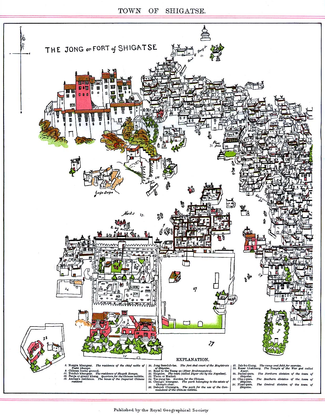
The imposing castle, Samdrubtse Dzong or "Shigatse Dzong", was probably built in the 15th century. It looked something like a smaller version of the Potala Palace in Lhasa, and had turret-like fortifications at the ends and a central Red Palace. It used to be the seat of the kings of Ü-Tsang and the capital of the province of Ü-Tsang or Tsang.<ref>Mayhew, Bradley and Kohn, Michael. (2005). Tibet, p. 172. 6th Edition. Lonely Planet Publications. Template:ISBN.</ref>
The castle was totally dismantled, rock by rock, by hundreds of Tibetans at the instigation of the Chinese in 1961.<ref>Tibet: a travel survival kit, p. 168. (1986). Michael Buckley and Robert Strauss. Lonely Planet Publications, South Yarra, Vic., Australia. Template:ISBN.</ref><ref>Tibet: A Fascinating Look at the Roof of the World, Its People and Culture, p. 115. (1982). Elisabeth B. Booz. Passport Books.</ref> Between 2005 and 2007, the building was reconstructed, financed by donations from Shanghai. Such "Preservation and Reparation Project of Sangzhutse Fortress of Shigatse City" was completed in May 2007 and was designed by the Construction Design Institute of Shanghai Tongji University. Old photographs served as a basis for the reconstruction, which was executed in concrete.<ref>Cp. Shigatse Dzong https://www.flickr.com/photos/anyongfu/744385254/</ref> Afterwards, the exterior was to be wainscotted with natural stones. The dzong, which in the 17th century served as a model for the construction of the Potala Palace, is set to become a museum for Tibetan culture.<ref>Template:Cite news</ref><ref>Template:Cite news</ref>
Nearby attractions include:
- Shalu Monastery
- Narthang, the first printing establishment in central Tibet<ref name="McCue 2010 p. 167">Template:Cite book</ref>
- Mount Everest
Infrastructure and transport
- Samzhubzê is the hub of the road network between Lhasa, Nepal and western Tibet.
- Construction started in 2010 of the Lhasa–Shigatse Railway to Samzhubzê and was completed in 2014. Start operated on 15 August 2014. A further extension to the Nepalese border is planned.<ref>"China: Building Starts on Rail Line to Tibet" article by Andrew Jacobs in The New York Times 27 September 2010, accessed 28 September 2010</ref>
- The nearest railhead in India is the station of New Jalpaiguri, a suburb of Siliguri, West Bengal.
- Shigatse Peace Airport began operations on 30 October 2010 and was Tibet's fifth commercial airport. It is located 43 kilometres from central Shigatse at Jangdam Township at an altitude of 3,782 metres. The airport is designed to handle up to 230,000 passengers annually by 2020.<ref>{{#invoke:citation/CS1|citation
|CitationClass=web }}</ref>
References
Citations
Sources
- Das, Sarat Chandra. 1902. Lhasa and Central Tibet. Reprint: Mehra Offset Press, Delhi. 1988. Template:ISBN
- Dorje, Gyurme. 1999. Footprint Tibet Handbook. 2nd Edition. Bath, England. Template:ISBN. Also published in Chicago, U.S.A. Template:ISBN.
- Dowman, Keith. 1988. The Power-Places of Central Tibet: The Pilgrim's Guide, p. 59. Routledge & Kegan Paul. London. Template:ISBN (ppk).
- Richardson, Hugh E (1984). Tibet and its History. Second Edition, Revised and Updated. Shambhala Publications, Boston. Template:ISBN.
External links
Template:Tibet Autonomous Region Template:Xigaze Prefecture Template:Towns in Xigazê Template:Authority control