Westwood, Queensland
Template:Use dmy dates Template:Use Australian English Template:GeoGroup Template:Infobox Australian place Westwood is a town in the Rockhampton Region and a locality split between the Rockhampton Region and the Shire of Banana in Queensland, Australia.<ref name=":0">Template:Cite QPN</ref><ref>Template:Cite QPN</ref><ref>Template:Cite QPN</ref> It was the first town that was gazetted by the Queensland Government. In the Template:CensusAU, the locality of Westwood had a population of 199 people.<ref name=Census2021/>
Geography
The northern half of the locality of Westwood is in Rockhampton region while the southern part is in the Shire of Banana.<ref name="globe">Template:Queensland Globe</ref>
The town is in the south-east of the locality with two other neighbourhoods in the north-east of locality
- Huxham (Template:Coord). It takes its name from the Huxham railway station, which in turn was named on 21 August 1919 by the Queensland Railways Department after John Saunders Huxham, the Home Secretary of Queensland.<ref name="qpn16551">Template:Cite QPN</ref>
- Spring Creek (Template:Coord)<ref name="qpn39319">Template:Cite QPN</ref>
The Capricorn Highway passes through the town, and the intersection with the Leichhardt Highway is a few kilometres to the southwest.<ref name="globe" />
The Blackwater railway line enters the locality from the north (Wycarbah), passes through the town, and exits to the south-west (Gogango).<ref name="globe" />
Westwood has the following mountains:<ref name="globenatural">{{#invoke:citation/CS1|citation |CitationClass=web }}</ref>
- Sugarloaf Mountain in the north-east of the locality (Template:Coord), rising to Template:Convert above sea level<ref name="MountainPeaksCapes">{{#invoke:citation/CS1|citation
|CitationClass=web }}</ref><ref>Template:Cite QPN</ref>
- Norman Head in the north-east of the locality (Template:Coord), Template:Convert<ref name="MountainPeaksCapes2">{{#invoke:citation/CS1|citation
|CitationClass=web }}</ref><ref>Template:Cite QPN</ref>
- Cobbler Mountain in the west of the locality (Template:Coord), Template:Convert<ref name="MountainPeaksCapes2" /><ref>Template:Cite QPN</ref>
- Sebastopol Mountain in the south of the locality (Template:Coord), Template:Convert<ref name="MountainPeaksCapes2" /><ref>Template:Cite QPN</ref>
The predominant land use is grazing on native vegetation.<ref name="globe" />
History


Although towns such as Brisbane, Maryborough and Rockhampton had been gazetted by the New South Wales Government prior to the separation of Queensland, Westwood was the first town to be gazetted by the newly established Queensland Government on 23 May 1860. Although the area was named Prestone on the original survey plan, Queensland Governor George Bowen decided to name the town Westwood after Westwood House, the home of Sir John Pakington, the Secretary of State for the Colonies and War in 1852.<ref name=":0" /><ref>{{#invoke:citation/CS1|citation |CitationClass=web }}</ref>
On 29 September 1867, the first stage of the Great Northern Railway (now known as the Central Western Line) reached the area from Rockhampton, and Westwood became the railhead.<ref>The Centenary of the Central Line Knowles, J.W. Australian Railway Historical Society Bulletin, September, 1967 pp181-202</ref> The first load of wool was railed from the town on 23 August.
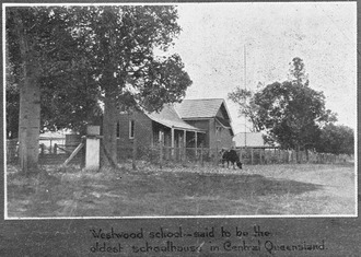
Westwood State School opened on 26 August 1872.<ref name=qs>Template:Cite QldSchool</ref><ref>Template:Cite QSA Agency</ref>
A Protestant church opened in Westwood on Thursday 2 October 1873.<ref>Template:Cite news</ref>
The town was meant to be the railhead for only a short time. However, bureaucracy and financial difficulties for the state meant that the next section of the line did not commence construction until 1873. The significance of Westwood declined when the railhead moved further west.
On Saturday 6 September 1919, John Huxham, the Queensland Home Secretary opened the Westwood Sanatorium,<ref>Template:Cite news</ref><ref>{{#invoke:citation/CS1|citation |CitationClass=web }}</ref> a 64-bed sanitorium was opened in Westwood to treat miner's phthisis,<ref>Template:Cite news</ref> a lung disease suffered by miners from working in dusty conditions. Later, it treated patients with Tuberculosis.<ref>Template:Cite journal</ref> In 1953, a ¾ mile bitumen road was built from the Huxham railway siding (just to the north of Westwood) to the sanitorium and named Haigh Drive in memory of Leonard Garfield Haigh, the former chairman of the Rockhampton Hospitals Board from 2 June 1933 to 16 February 1953. Commencing with a tiled-roof waiting shed at the siding with a plaque commemorating Haigh, the drive to the sanitorium was flanked with Peltophorum trees and was officially opened by James Larcombe (MLA for Rockhampton) in the presence of Haigh's widow on Sunday 1 November 1953.<ref>Template:Cite news</ref><ref>Template:Cite news</ref> More effective medical treatments for tuberculous resulted in the closure of the sanitorium in 1959, but the building continued to be used as a nursing home until the 1980s. The sanitorium buildings were then relocated or demolished; one is in use as a private home in Emerald.<ref>{{#invoke:citation/CS1|citation |CitationClass=web }}</ref>
In 1996, Westwood held its first Anzac Day ceremony at its new memorial which was dedicated the same day.<ref>{{#invoke:citation/CS1|citation |CitationClass=web }}</ref> The event, organised by the Westwood Progress Association, was attended by approximately 80 people including official guests Fitzroy Shire mayor Mary Seierup, state MP Jim Pearce and federal MP Paul Marek.<ref name=anzac>{{#invoke:citation/CS1|citation |CitationClass=web }}</ref> Fitzroy Shire councillor Vince Reynolds was the master of ceremonies while Uniting Church pastor Dorothy Demack served as the worship leader.<ref name=anzac/>
Westwood was in the Shire of Fitzroy until local government amalgamations in 2008 resulted in it being in the Rockhampton Region.<ref>{{#invoke:citation/CS1|citation |CitationClass=web }}</ref>
Demographics
In the Template:CensusAU, the locality of Westwood and the surrounding area had a population of 253 people.<ref name="Census2006">Template:Census 2006 AUS</ref>
In the Template:CensusAU, the locality of Westwood had a population of 240 people.<ref name="Census2011/">Template:Census 2011 AUS</ref>
In the Template:CensusAU, the locality of Westwood had a population of 174 people.<ref name=Census2016>Template:Census 2016 AUS</ref>
In the Template:CensusAU, the locality of Westwood had a population of 199 people.<ref name=Census2021>Template:Census 2021 AUS</ref>
Heritage listings
Westwood has the following heritage-listed sites:
- remains of the Adolphus William Copper Smelter<ref>Template:Cite QHR</ref>
Education
Westwood State School is a government primary (Prep-6) school for boys and girls at 108 Herbert Street (Template:Coord).<ref name=SchoolList2018>{{#invoke:citation/CS1|citation |CitationClass=web }}</ref><ref>{{#invoke:citation/CS1|citation |CitationClass=web }}</ref> In 2017, the school had an enrolment of 13 students with 2 teachers (1 full-time equivalent) and 4 non-teaching staff (2 full-time equivalent).<ref name=ACARA2017>{{#invoke:citation/CS1|citation |CitationClass=web }}</ref> In 2022, the school had 20 students.<ref>{{#invoke:citation/CS1|citation |CitationClass=web }}</ref>
There are no secondary schools in Westwood. The nearest government secondary school is Rockhampton State High School in Wandal, Rockhampton to the north-east.<ref name="globe" />
References
Further reading
External links
- {{#invoke:citation/CS1|citation
|CitationClass=web }}
- {{#invoke:citation/CS1|citation
|CitationClass=web }}
Template:Rockhampton Region Template:Banana Shire Template:Central Queensland