Ajigasawa, Aomori
Template:Main other{{#invoke:Infobox|infobox}}Template:Template other{{#invoke:Check for unknown parameters|check|unknown=Template:Main other|preview = Page using [[Template:Template:If empty]] with unknown parameter "_VALUE_"|ignoreblank=y|mapframe_args=y | alt | anthem | anthem_link | area_blank1_acre | area_blank1_dunam | area_blank1_ha | area_blank1_km2 | area_blank1_sq_mi | area_blank1_title | area_blank2_acre | area_blank2_dunam | area_blank2_ha | area_blank2_km2 | area_blank2_sq_mi | area_blank2_title | area_code | area_code_type | area_codes | area_footnotes | area_land_acre | area_land_dunam | area_land_ha | area_land_km2 | area_land_sq_mi | area_metro_acre | area_metro_dunam | area_metro_footnotes | area_metro_ha | area_metro_km2 | area_metro_sq_mi | area_note | area_rank | area_rural_acre | area_rural_dunam | area_rural_footnotes | area_rural_ha | area_rural_km2 | area_rural_sq_mi | area_total_acre | area_total_dunam | area_total_ha | area_total_km2 | area_total_sq_mi | area_urban_acre | area_urban_dunam | area_urban_footnotes | area_urban_ha | area_urban_km2 | area_urban_sq_mi | area_water_acre | area_water_dunam | area_water_ha | area_water_km2 | area_water_percent | area_water_sq_mi | blank_emblem_alt | blank_emblem_link | blank_emblem_size | blank_emblem_type | blank_emblem_sizedefault | blank_emblem_upright | blank_info | blank_info_sec1 | blank_info_sec2 | blank_name | blank_name_sec1 | blank_name_sec2 | blank1_info | blank1_info_sec1 | blank1_info_sec2 | blank1_name | blank1_name_sec1 | blank1_name_sec2 | blank2_info | blank2_info_sec1 | blank2_info_sec2 | blank2_name | blank2_name_sec1 | blank2_name_sec2 | blank3_info | blank3_info_sec1 | blank3_info_sec2 | blank3_name | blank3_name_sec1 | blank3_name_sec2 | blank4_info | blank4_info_sec1 | blank4_info_sec2 | blank4_name | blank4_name_sec1 | blank4_name_sec2 | blank5_info | blank5_info_sec1 | blank5_info_sec2 | blank5_name | blank5_name_sec1 | blank5_name_sec2 | blank6_info | blank6_info_sec1 | blank6_info_sec2 | blank6_name | blank6_name_sec1 | blank6_name_sec2 | blank7_info | blank7_info_sec1 | blank7_info_sec2 | blank7_name | blank7_name_sec1 | blank7_name_sec2 | caption | code1_info | code1_name | code2_info | code2_name | coor_pinpoint | coor_type | coordinates | coordinates_footnotes | demographics_type1 | demographics_type2 | demographics1_footnotes | demographics1_info1 | demographics1_info10 | demographics1_info2 | demographics1_info3 | demographics1_info4 | demographics1_info5 | demographics1_info6 | demographics1_info7 | demographics1_info8 | demographics1_info9 | demographics1_title1 | demographics1_title10 | demographics1_title2 | demographics1_title3 | demographics1_title4 | demographics1_title5 | demographics1_title6 | demographics1_title7 | demographics1_title8 | demographics1_title9 | demographics2_footnotes | demographics2_info1 | demographics2_info10 | demographics2_info2 | demographics2_info3 | demographics2_info4 | demographics2_info5 | demographics2_info6 | demographics2_info7 | demographics2_info8 | demographics2_info9 | demographics2_title1 | demographics2_title10 | demographics2_title2 | demographics2_title3 | demographics2_title4 | demographics2_title5 | demographics2_title6 | demographics2_title7 | demographics2_title8 | demographics2_title9 | dimensions_footnotes | dunam_link | elevation_footnotes | elevation_ft | elevation_link | elevation_m | elevation_max_footnotes | elevation_max_ft | elevation_max_m | elevation_max_point | elevation_max_rank | elevation_min_footnotes | elevation_min_ft | elevation_min_m | elevation_min_point | elevation_min_rank | elevation_point | embed | established_date | established_date1 | established_date2 | established_date3 | established_date4 | established_date5 | established_date6 | established_date7 | established_title | established_title1 | established_title2 | established_title3 | established_title4 | established_title5 | established_title6 | established_title7 | etymology | extinct_date | extinct_title | flag_alt | flag_border | flag_link | flag_size | footnotes | founder | geocode | governing_body | government_footnotes | government_type | government_blank1_title | government_blank1 | government_blank2_title | government_blank2 | government_blank2_title | government_blank3 | government_blank3_title | government_blank3 | government_blank4_title | government_blank4 | government_blank5_title | government_blank5 | government_blank6_title | government_blank6 | grid_name | grid_position | image_alt | image_blank_emblem | image_caption | image_flag | image_map | image_map1 | image_seal | image_shield | image_size | image_skyline | imagesize | image_sizedefault | image_upright | iso_code | leader_name | leader_name1 | leader_name2 | leader_name3 | leader_name4 | leader_name5 | leader_party | leader_title | leader_title1 | leader_title2 | leader_title3 | leader_title4 | leader_title5 | length_km | length_mi | map_alt | map_alt1 | map_caption | map_caption1 | mapsize | mapsize1 | module | motto | motto_link | mottoes | name | named_for | native_name | native_name_lang | nickname | nickname_link | nicknames | official_name | other_name | p1 | p10 | p11 | p12 | p13 | p14 | p15 | p16 | p17 | p18 | p19 | p2 | p20 | p21 | p22 | p23 | p24 | p25 | p26 | p27 | p28 | p29 | p3 | p30 | p31 | p32 | p33 | p34 | p35 | p36 | p37 | p38 | p39 | p4 | p40 | p41 | p42 | p43 | p44 | p45 | p46 | p47 | p48 | p49 | p5 | p50 | p6 | p7 | p8 | p9 | parts | parts_style | parts_type | pop_est_as_of | pop_est_footnotes | population | population_as_of | population_blank1 | population_blank1_footnotes | population_blank1_title | population_blank2 | population_blank2_footnotes | population_blank2_title | population_demonym | population_demonyms | population_density_blank1_km2 | population_density_blank1_sq_mi | population_density_blank2_km2 | population_density_blank2_sq_mi | population_density_km2 | population_density_metro_km2 | population_density_metro_sq_mi | population_density_rank | population_density_rural_km2 | population_density_rural_sq_mi | population_density_sq_mi | population_density_urban_km2 | population_density_urban_sq_mi | population_est | population_footnotes | population_metro | population_metro_footnotes | population_note | population_rank | population_rural | population_rural_footnotes | population_total | population_urban | population_urban_footnotes | postal_code | postal_code_type | postal2_code | postal2_code_type | pushpin_image | pushpin_label | pushpin_label_position | pushpin_map | pushpin_map_alt | pushpin_map_caption | pushpin_map_caption_notsmall | pushpin_map_narrow | pushpin_mapsize | pushpin_outside | pushpin_overlay | pushpin_relief | registration_plate | registration_plate_type | seal_alt | seal_link | seal_size | seal_type | seat | seat_type | seat1 | seat1_type | seat2 | seat2_type | settlement_type | shield_alt | shield_link | shield_size | short_description | subdivision_name | subdivision_name1 | subdivision_name2 | subdivision_name3 | subdivision_name4 | subdivision_name5 | subdivision_name6 | subdivision_type | subdivision_type1 | subdivision_type2 | subdivision_type3 | subdivision_type4 | subdivision_type5 | subdivision_type6 | template_name | timezone | timezone_DST | timezone_link | timezone1 | timezone1_DST | timezone1_location | timezone2 | timezone2_DST | timezone2_location | timezone3 | timezone3_DST | timezone3_location | timezone4 | timezone4_DST | timezone4_location | timezone5 | timezone5_DST | timezone5_location | total_type | translit_lang1 | translit_lang1_info | translit_lang1_info1 | translit_lang1_info2 | translit_lang1_info3 | translit_lang1_info4 | translit_lang1_info5 | translit_lang1_info6 | translit_lang1_type | translit_lang1_type1 | translit_lang1_type2 | translit_lang1_type3 | translit_lang1_type4 | translit_lang1_type5 | translit_lang1_type6 | translit_lang2 | translit_lang2_info | translit_lang2_info1 | translit_lang2_info2 | translit_lang2_info3 | translit_lang2_info4 | translit_lang2_info5 | translit_lang2_info6 | translit_lang2_type | translit_lang2_type1 | translit_lang2_type2 | translit_lang2_type3 | translit_lang2_type4 | translit_lang2_type5 | translit_lang2_type6 | type | unit_pref | utc_offset | utc_offset_DST | utc_offset1 | utc_offset1_DST | utc_offset2 | utc_offset2_DST | utc_offset3 | utc_offset3_DST | utc_offset4 | utc_offset4_DST | utc_offset5 | utc_offset5_DST | website | width_km | width_mi }}{{#invoke:Check for clobbered parameters|check | template = [[Template:Template:If empty]] | cat = Template:Main other | population; population_total | image_size; imagesize | image_alt; alt | image_caption; caption | settlement_type; type | utc_offset1; utc_offset | timezone1; timezone }}{{#if:
|
}}Template:Main other{{#ifexpr:{{#invoke:ParameterCount|main|mapframe|image_map|image_map1|pushpin_map}} >2 |Template:Main other}}


Template:Nihongo is a town located in Aomori Prefecture, Japan. Template:As of, the town had an estimated population of 8,951 in 4394 households,<ref>Ajigsawa Town official statisticsTemplate:In lang</ref> and a population density of 26 persons per km2. The total area of the town is Template:Convert.
Geography
Ajigasawa is in Nishitsugaru District, Aomori southwestern corner of Aomori Prefecture on the border with Akita Prefecture, facing the Sea of Japan to the northwest, and the slopes of Mount Iwaki to the southeast. Part of the town is located within the borders of the Shirakami-Sanchi, a UNESCO World Heritage Site, and some coastal areas of the town are within the Tsugaru Quasi-National Park. The Akaishi Keiryū Anmon no Taki Prefectural Natural Park is also partly located within the borders of Ajigasawa.
Neighbouring municipalities
Akita Prefecture
Aomori Prefecture
Climate
The town has a cold humid continental climate (Köppen Dfb) characterized by warm short summers and long cold winters with heavy snowfall. The average annual temperature in Ajigasawa is 10.7 °C. The average annual rainfall is 1480 mm with September as the wettest month. The temperatures are highest on average in August, at around 22.9 °C, and lowest in January, at around −3.1 °C.<ref>Ajigasawa climate data</ref> Template:Weather box
Demographics
Per Japanese census data,<ref>Ajigasawa population statistics</ref> the population of Ajigasawa has decreased by more than half over the past 60 years.
Template:Historical populations
History
Oura Mitsunobu, the founder of the Tsugaru clan, settled in Tanesato (now part of Ajigasawa) in 1491, which developed into a port for the Tsugaru region. The area around Ajigasawa was controlled by the Tsugaru clan of Hirosaki Domain during the Edo period. Ajigasawa became a village in Nishitsugaru District, Aomori with the establishment of the modern municipalities system on April 1, 1889, and was elevated to town status on March 31, 1955 by annexing the neighboring villages of Akaishi, Nakamura, Narusawa and Maido.
Government
Ajigasawa has a mayor-council form of government with a directly elected mayor and a unicameral town legislature of 12 members. Nishitsugaru District contributes one member to the Aomori Prefectural Assembly. In terms of national politics, the town is part of Aomori 3rd district of the lower house of the Diet of Japan.
Economy
The economy of Ajigasawa is heavily dependent on agriculture (rice and horticulture) and on commercial fishing, especially for squid. Other species commonly caught in the local waters include the Japanese flounder, Japanese horse mackerel, Atka mackerel, red snapper, cod, angler fish, octopus, sharks and salmon.
Education
Ajigasawa has two public elementary schools and one public junior high schools operated by the town government and one public high school operated by the Aomori Prefectural Board of Education.
The Shirakami Nature School is a non-profit organization that is housed in a 19th-century wooden building that was used as an elementary school until the spring of 2003. The Shirakami Nature School hosts a wide variety of environmental education including classroom activities and open-air classes to people of all ages.
Transportation
Railway
![]() East Japan Railway Company (JR East) - Gonō Line
East Japan Railway Company (JR East) - Gonō Line
Highway
International relations
- Template:Flagicon – São Sebastião, São Paulo, Brazil since October 26, 1984 <ref name=International>{{#invoke:citation/CS1|citation
|CitationClass=web }}</ref>
Local attractions
- The Kikuya squid stand on the outskirts of town is the home of Wasao, an Akita dog that garnered nationwide attention after starring in a 2011 feature film which was filmed on location in the town.
- Aomori Spring Ski Resort (formerly known as NAQUA Shirakami Ski Resort).
- Aomori Spring Golf Club
- Rockwood Hotel & Spa
- Ajigasawa Beach is about a ten-minute walk from the train station and has both grass and sand areas with a view of the Sea of Japan.
- Umi No Eki “Wando” is a collection of stores, much like a market, that sells local goods directly from the farmers and fishermen. The products sold here are all local, and very fresh.
- Shirakami-Sanchi – UNESCO World Heritage Site
- Otaka-yama park is open to the public and includes a multipurpose stadium, tennis courts, amphitheater, go-carts and an elaborate playground.
- Template:Nihongo, gets its name from its appearance; it looks like a standing black bear. It is one of Japan’s Top 100 Waterfalls.
- Tanesato Castle ruins, a National Historic Site<ref>Agency for Cultural Affairs Template:In lang</ref>*Akaishi Keiryū Anmon no Taki Prefectural Natural Park
Noted people from Ajigasawa
- Hiyori Kon, sumo wrestler
- Mainoumi Shuhei, sumo wrestler
- Homarefuji Yoshiyuki, sumo wrestler
Gallery
-
 Formerly town office
 -
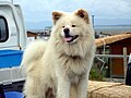 Wasao
Wasao -
 Kurokuma Falls
 -
 Rice fields near Minami Kanazawa
 -
 Dried Cuttlefish Curtain


References
External links
Template:Commons category-inline
{{#invoke:Navbox|navbox}} Template:Authority control