Broadway Bridge (Manhattan)
Template:Short description Template:Use American English Template:Use mdy dates Template:Good article Template:Infobox Bridge
The Broadway Bridge is a vertical-lift bridge across the Harlem River Ship Canal in the borough of Manhattan in New York City. It connects the neighborhoods of Inwood on Manhattan Island and Marble Hill on the mainland. The bridge consists of two decks. The lower deck carries Broadway, which is designated as U.S. Route 9 at this location. The upper deck carries the New York City Subway's IRT Broadway–Seventh Avenue Line, serving the Template:NYCS trains.
The site was previously occupied by two successive swing bridges. The first, known as the Harlem Ship Canal Bridge, was built between 1893 and 1895 to cross the canal, which had been constructed to bypass a meandering alignment of the Spuyten Duyvil Creek. By the first decade of the 20th century, the construction of the city's first subway line had made the original bridge obsolete, and a double-decker span called the 225th Street Bridge was built to accommodate the subway line above highway traffic. Between 1905 and 1906, the second bridge was installed, and the first bridge was relocated southward on the Harlem River, becoming the University Heights Bridge.
The current bridge was constructed between 1957 and 1962 to replace the second span. It contains a navigable channel Template:Convert wide. The bridge provides Template:Convert of vertical clearance when it is in the open position and Template:Convert of vertical clearance in the closed position.
Description
The Broadway Bridge is a double-deck vertical-lift bridge crossing the Harlem River Ship Canal in the New York City borough of Manhattan. It carries Broadway, also known as U.S. Route 9, on the lower level and three New York City Subway tracks on the upper level.<ref name="NYCDOT1">{{#invoke:citation/CS1|citation |CitationClass=web }}</ref> Although the bridge serves as a route for traffic between Manhattan and the Bronx, it is entirely in Manhattan. The southern end of the bridge is in Inwood, on Manhattan Island, while the northern end is in Marble Hill, on the mainland United States.<ref name="NYCityMap">{{#invoke:citation/CS1|citation |CitationClass=web }}</ref><ref>Template:Cite news</ref> The bridge also passes over the Metro-North Railroad's Hudson Line on its northern end.<ref name="NYCityMap" />
The lower level is used by the Template:NYC bus link local bus routes, operated by MTA New York City Transit, and the Template:NYC bus link express bus route operated by the MTA Bus Company.<ref>Template:Cite NYC bus map</ref> The subway tracks carry the Broadway–Seventh Avenue Line (Template:NYCS trains). Immediately to the north of the bridge along this line is the Marble Hill–225th Street station.<ref>Template:NYCS const</ref> In 2016, the New York City Department of Transportation, which operates and maintains the bridge, reported an average daily traffic volume in both directions of 36,027.<ref name="nyc-bridge"/> The peak ADT over the Broadway Bridge was 42,555 vehicles in 1990.<ref>{{#invoke:citation/CS1|citation |CitationClass=web }}</ref> Between 2000 and 2014, the bridge opened for vessels 434 times.<ref>{{#invoke:citation/CS1|citation |CitationClass=web }}</ref>
The bridge measures Template:Convert long, including approaches.<ref name="NYCDOT1" /><ref>Template:Cite book</ref> The lift span is Template:Convert long<ref name="NYCDOT1" /><ref name="New York Area Roads, Crossings and Exits 1905">{{#invoke:citation/CS1|citation |CitationClass=web }}</ref><ref name="The Municipal Engineers Journal 1960 p. 178">Template:Cite book</ref> and sits Template:Convert above mean high water in the "closed" position, though it can be raised to Template:Convert above mean high water.<ref name="nyt19631101">Template:Cite news</ref><ref name="New York (N.Y.) Dept. of Public Works 1955 p.">Template:Cite book</ref> It weighs Template:Convert<ref name="New York (N.Y.) Dept. of Public Works 1955 p." /> and is composed of two Warren trusses.<ref name="The Municipal Engineers Journal 1960 p. 178" /> The lift span is supported by the lift towers at each end, which rise Template:Convert above mean water.<ref name="New York (N.Y.) Dept. of Public Works 1955 p." /> The lift span is suspended by two sets of 12 wire ropes at each corner. Each rope is wrapped around counterweights on each end: at the top of each tower and on the span. The span can be lifted by one electrical drive in each tower. The tops of the lift towers were tapered to be flush with the top of the lift span.<ref name="New York Area Roads, Crossings and Exits 1905" /><ref name="New York (N.Y.) Dept. of Public Works 1955 p." />
The lower deck contains two roadways and sidewalks, one on each of the west and east sides. The roadways are each Template:Convert wide, carrying one direction of traffic on Broadway, and the sidewalks are each Template:Convert wide. A median divides the two roadways.<ref name="NYCDOT1" /><ref name="New York Area Roads, Crossings and Exits 1905" /><ref name="New York (N.Y.) Dept. of Public Works 1955 p." /> In addition, there are Template:Convert of subway and electrical conduits along the bottom of the Harlem Ship Canal.<ref>Template:Cite news</ref><ref>Template:Cite news</ref> The conduits had to be placed in a trench at the bottom of the canal because it was infeasible to place fixed conduits on the movable span.<ref>{{#invoke:citation/CS1|citation |CitationClass=web }}</ref>
Previous spans
The first span at the site, the Harlem Ship Canal Bridge, was a single-deck swing bridge. It measured Template:Convert from end to end,<ref name="Burr p. 3">Template:Harvnb</ref><ref>Template:Cite news</ref> or Template:Convert excluding stone abutments.<ref name="ER p. 116">Template:Harvnb</ref> It was constructed with four sections supported by three masonry piers. The two central sections comprised the swing span, which pivoted around a small masonry island in the middle of the canal. On either side of the masonry island were navigable openings that measured Template:Convert wide at mean high water.<ref name="Burr p. 3" /><ref name="ER p. 116" /><ref name="nyt18930201">Template:Cite news</ref> The swing span was flanked by two Template:Convert approach structures, as well as stone abutments.<ref name="Burr p. 3" /><ref name="ER p. 116" /> It was operated by steam engines.<ref name="NYCDOT1" /><ref name="ER p. 116" /> The bridge had a total width of Template:Convert, with a roadway of Template:Convert and two sidewalks of Template:Convert.<ref name="ER p. 116" /><ref name="nyt18930201" /><ref name="Burr p. 4" /> The bridge weighed Template:Convert, with the machinery comprising one-sixth of the weight.<ref name="tribune19040814">Template:Cite news</ref>
The second span, the 225th Street Bridge, was a double-deck swing bridge. The upper deck carried the subway tracks while the lower deck carried a Template:Convert road, two Template:Convert sidewalks, and the Metropolitan Street Railway's streetcar tracks.<ref name="ER p. 116" /><ref name="tribune19040814" /><ref name="Howe p. 3">Template:Harvnb</ref> There was room for three vehicular lanes.<ref name="The Municipal Engineers Journal 1960 p. 178" /><ref name="nyt19490718">Template:Cite news</ref> The swing span was Template:Convert long and, when closed, provided Template:Convert of vertical clearance and Template:Convert of horizontal clearance.<ref name="New York Area Roads, Crossings and Exits 1905" /> It weighed Template:Convert and was operated by two electric motors, each of Template:Convert.<ref name="Howe p. 13" /> The approach spans had riveted Warren trusses about Template:Convert deep with their centers spaced Template:Convert apart.<ref name="ER p. 116" /> The south approach measured Template:Convert in length and weighed Template:Convert, while the north approach measured Template:Convert in length and weighed Template:Convert.<ref name="ER p. 116" /><ref name="Howe pp. 4-5">Template:Harvnb</ref>
History
_-_re-tinted_Marble_Hill_detail.png)
Prior to the construction of the Harlem River Ship Canal, Marble Hill was part of Manhattan Island, and the Spuyten Duyvil Creek made a tight curve around the northern shore of Marble Hill, connecting the Hudson River on the west shore of Manhattan Island with Harlem River on the east shore.<ref name="NYCL p. 2">Template:Harvnb</ref><ref name="Kadinsky2016" /> Early crossings of the creek included the King's Bridge, opened in 1693,<ref name="Kadinsky2016" /><ref>{{#invoke:citation/CS1|citation |CitationClass=web }}</ref><ref name="Howe p. 1; NYCL p. 2">Template:Harvnb; Template:Harvnb</ref> and the Free (or Farmers) Bridge, opened in 1759.<ref name="Howe p. 1; NYCL p. 2" /><ref name="NYCPks-SpuytenDuyvilCrk" /><ref>Template:Cite book</ref> Both bridges were relatively narrow; the King's Bridge was Template:Convert wide and the Farmers Bridge was Template:Convert wide.<ref>Template:Harvnb</ref>
Though plans to connect the Harlem and Hudson rivers with a more straightforward path were proposed in the early 19th century,<ref name="Kadinsky2016">Template:Cite Hidden Waters NYC</ref><ref>Template:Harvnb</ref> construction of the Harlem River Ship Channel did not start until January 1888.<ref>Template:Harvnb</ref><ref>Template:Cite book</ref> Furthermore, as a result of the River and Harbor Act, passed by the United States Congress in 1890, bridges on the Harlem River with low vertical clearance were to be replaced with those with at least Template:Convert of clearance during mean high water springs. Drawbridges and swing spans were determined to be most suitable for this purpose.<ref name="Burr p. 3" /><ref>Template:Cite book</ref><ref>Template:Cite news</ref>
First span
In accordance with the canal project and the congressional legislation, in 1892, the New York City Department of Public Works was commissioned to build a bridge connecting Inwood and Marble Hill, which would carry Broadway.<ref name="NYCL p. 2" /><ref>Template:Cite book</ref> A corresponding state law, passed that April, allocated $400,000 (Template:InflationTemplate:Inflation/fn) to the project.<ref name="nyt18920407" /><ref>Template:Cite news</ref> The canal was to be opened only after the bridge's abutments were constructed, thus saving the bridge's builders $50,000 (Template:InflationTemplate:Inflation/fn) by allowing them to construct the abutments in the dry canal bed.<ref name="nyt18920407">Template:Cite news</ref> The New York City Board of Estimate approved the Harlem Ship Canal Bridge in February 1893.<ref name="nyt18930201" /> William Hubert Burr, Alfred P. Boller, and George W. Birdsall were named as the bridge's architects, while A. McMullen & Co. was named as contractor.<ref name="NYCL p. 2" />
When the bridge and canal were being constructed, one Template:Convert dam was placed at each end of the canal; any leaks were pumped away by steam engines. The bridge's piers were then installed in the path of the canal.<ref name="Burr p. 4">Template:Harvnb</ref> During construction, in April 1893, the dams were destroyed in a heavy storm, causing the canal bed to be flooded before the canal was completed.<ref name="Burr p. 4" /><ref>Template:Cite news</ref> The foundations for the bridge's abutments were sunk into the bed of the canal using caissons.<ref name="ER p. 116" /><ref>Template:Harvnb</ref> The bridge opened on January 1, 1895.<ref name="tribune19040814" /><ref name="NYCL p. 2" /><ref>Template:Cite news</ref> At the time, it was one of several swing bridges that had been built on the Harlem River, and it was the second-oldest major bridge in New York City behind the Brooklyn Bridge.<ref name="NYCL p. 2" /> After the Marble Hill section of the canal opened on June 17, 1895, the Harlem Ship Canal Bridge was able to swing open for boat traffic.<ref name="NYCPks-SpuytenDuyvilCrk">{{#invoke:citation/CS1|citation |CitationClass=web }}</ref><ref>Template:Harvnb</ref><ref>Template:Cite news</ref>
The Harlem Ship Canal Bridge connected the islands of Manhattan and Marble Hill, as the Spuyten Duyvil Creek continued to flow around the northern side of Marble Hill until 1914.<ref>{{#invoke:citation/CS1|citation |CitationClass=web }}</ref> Another bridge on the northern side of Marble Hill opened in 1900; it carried Broadway over the old creek bed and, along with the King's and Farmers' Bridges, provided direct connections to the Bronx. That span, which had also been called the Broadway Bridge, was demolished by the late 1920s.<ref>Template:Cite news</ref>
Second span
Around 1900, the city sold the Harlem Ship Canal Bridge to the Rapid Transit Construction Company, which was building the first city subway line.<ref name="nyt19031227">Template:Cite news</ref> The subway's West Side Branch was to cross the Harlem River Ship Canal above Broadway, which necessitated modifying or replacing the existing bridge.<ref>Template:Cite news</ref> The Interborough Rapid Transit Company (IRT), which had been formed to operate the subway, determined the existing structure could not support the elevated subway line,<ref name="ER p. 116" /><ref name="nyt19051107" /><ref name="tribune19051107" /> choosing instead to build a second, double-decker swing bridge.<ref name="NYCDOT1" /><ref name="aia5">Template:Cite aia5</ref> The old substructure was deemed to be sufficiently strong to support the weight of a new span.<ref name="ER p. 116" /> The need to replace the Harlem Ship Canal Bridge was further emphasized in 1903,<ref name="NYCL p. 6">Template:Harvnb</ref><ref>Template:Cite book</ref> when the New York State Legislature passed legislation allowing the realignment of the New York Central Railroad's Spuyten Duyvil Line (now the Metro-North Railroad's Hudson Line) along the Harlem River's eastern bank.<ref>Template:Cite book</ref> The railroad wished to avoid a grade crossing with the Metropolitan Street Railway's streetcar tracks, to be built on the lower deck.<ref name="tribune19040814" /><ref name="nyt19031227" /> Ultimately, the city made an agreement with the three railroads to relocate the first span down the Harlem River, only ten years after it had been constructed.<ref name="Howe p. 3" /><ref name=aia5/><ref name="NYCL p. 6" /> The old Harlem Ship Canal Bridge became the University Heights Bridge, which opened in 1908.<ref name="Howe p. 13">Template:Harvnb</ref><ref>Template:Cite news</ref><ref>Template:Cite news</ref>
The American Bridge Company was contracted to construct the new bridge.<ref name="ER p. 116" /> The temporary framework for the second bridge's swing span was constructed at 216th Street in Manhattan, slightly south of the bridge site. The approach spans were constructed next to Broadway, along the shore where they were to be installed.<ref name="ER p. 116" /><ref name="Burr p. 4" /> Pile-driving for the new swing span began at 216th Street in May 1905 and was finished that September.<ref name="Burr p. 4" /> The approach spans were built on crib piers that rested along flatcars, with each span slightly overhanging the shore on either end. After the approach spans were completed, the approach spans were pushed off the flatcars and floated onto scows.<ref name="Howe pp. 4-5" /><ref>Template:Harvnb</ref> The spans of the old Harlem Ship Canal Bridge were replaced with the new double-decker spans in three phases. Traffic on Broadway was not to be interrupted for more than five days total. After the old spans were disconnected from their old location and moved aside, the corresponding sections of the second bridge were floated into place.<ref>Template:Harvnb</ref> The southern approach at Broadway was replaced in October 1905,<ref>Template:Harvnb</ref><ref>Template:Cite news</ref> followed by the northern approach in November.<ref name="nyt19051107">Template:Cite news</ref><ref name="tribune19051107">Template:Cite news</ref><ref>Template:Harvnb</ref> The old swing span was replaced with the new swing span in June 1906.<ref>Template:Harvnb</ref><ref>Template:Harvnb</ref> The second span ultimately cost $1,182,782 to install.<ref name="NYCDOT1" /> When the IRT's West Side Branch was extended in March 1906, it had a temporary terminal at 221st Street, just south of the bridge's Manhattan end.<ref>Template:Cite book</ref><ref>Template:Cite news</ref> Subway service was extended over the Broadway Bridge to Marble Hill–225th Street in January 1907 and the 221st Street station was closed.<ref>Template:Cite news</ref>
By the early 1930s, there were proposals to build the long-delayed Henry Hudson Bridge to the west, carrying traffic on the Henry Hudson Parkway (New York State Route 9A). The project was being upheld as a way to alleviate traffic on the Broadway Bridge, which in 1933 accommodated 28,000 vehicles a day, almost as much as the Holland Tunnel between New Jersey and New York.<ref>Template:Cite news</ref> While the Henry Hudson Bridge was to be a toll bridge, the Broadway Bridge charged no toll for the eleven million vehicles that, at the time, crossed it every year.<ref>Template:Cite news</ref> In mid-December 1934, the section of Broadway across the bridge was signed as US 9 within New York City for the first time, as were several other U.S. Highways and state routes. The section of US 9 south of the bridge ran to 179th Street, turning west to the George Washington Bridge to New Jersey, while the section north of the bridge ran to the Bronx and Westchester County.<ref>Template:Cite news</ref> The Henry Hudson Bridge opened in 1936.<ref>{{#invoke:citation/CS1|citation |CitationClass=web }}</ref><ref>Template:Cite news</ref>
In 1949, the city's commissioner of public works proposed that a lift bridge be built for $7.64 million (equivalent to $Template:Inflation million in Template:Inflation/yearTemplate:Inflation/fn) to replace the second Broadway Bridge. The swing span's three vehicular lanes could no longer accommodate modern traffic loads, and a lift span would provide more horizontal clearance for marine traffic. As part of this proposal, the lift bridge would carry six lanes, and the sections of Broadway on either side of the bridge would be widened to Template:Convert.<ref name="nyt19490718" /><ref>Template:Cite news</ref> The Bridge Department again called for the construction of a lift bridge in 1956, this time at a cost of $12.71 million (equivalent to $Template:Inflation million in Template:Inflation/yearTemplate:Inflation/fn), although the city would still not include money for a new bridge in its budget.<ref name="nyt19561012">Template:Cite news</ref> The 225th Street Bridge was damaged by fire that October,<ref name="nyt19561012" /><ref>Template:Cite news</ref> requiring it to be closed for emergency repairs.<ref>Template:Cite news</ref> In January 1957, Public Works Commissioner Frederick H. Zurmuhlen announced that the swing bridge had sustained more severe damage than originally projected, and that it would be difficult to close the swing span due to warping of the steel beams.<ref>Template:Cite news</ref> The swing bridge was closed to tall marine vessels in 1957.<ref name="nyt19631101" />
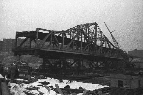
Third span
Zurmuhlen announced in February 1958 that work would commence on a new lift span costing $13.4 million (equivalent to $Template:Inflation million in Template:Inflation/yearTemplate:Inflation/fn). The first phase of the work was awarded to the Moore & Lopier Construction Corporation and involved constructing new piers parallel to the second swing span.<ref>Template:Cite news</ref> The American Bridge Company constructed the new lift span on the Bronx side of the bridge. Because the second 225th Street Bridge was so heavily used, with an average of 23,000 vehicles per weekday, the lift span was built before the lift towers, in the opposite sequence from other lift bridges.<ref>Template:Cite news</ref> A construction schedule was planned so that subway traffic would be disrupted as little as possible.<ref name="New York (N.Y.) Dept. of Public Works 1955 p." />
At the end of November 1960, the second bridge was closed to vehicular traffic, but remained open for subway operation.<ref>Template:Cite news</ref><ref>Template:Cite news</ref> Subway service on the bridge was suspended for three days starting on December 23, 1960, to install the lift span during the Christmas weekend.<ref>Template:Cite news</ref> High winds delayed the installation of the lift span by one day.<ref>Template:Cite news</ref> Subway service and pedestrian crossings resumed on December 26; the iron-grating roadbed had yet to be welded at the time. The second swing span was towed to just north of the University Heights Bridge, where it was cut up into scrap.<ref>Template:Cite news</ref> The new lift bridge opened to vehicles in January 1961,<ref name="nyt19631101" /> but was closed to vehicles again that July. This closure allowed the lift machinery to be installed and the approach roadways to be rebuilt.<ref>Template:Cite news</ref><ref>Template:Cite news</ref> The eastern roadway of the new bridge reopened to two-way vehicular traffic on July 1, 1962, while the western roadway opened that November.<ref>Template:Cite news</ref> After further intermittent closures to marine, road, and subway traffic, work was complete by November 1963.<ref name="nyt19631101" />
Mayor John Lindsay proposed enacting tolls along the University Heights Bridge, as well as all other free bridges across the East and Harlem rivers, in 1971.<ref>Template:Cite news</ref><ref>Template:Cite news</ref> The proposal failed in 1977 after the United States Congress moved to ban tolls on these bridges.<ref>Template:Cite news</ref>
The NYCDOT made some minor renovations to the Broadway Bridge in 2003.<ref>Template:Cite news</ref> The work, costing $10 million, included repairs to the deck as well as placing a protective coating on the lift span's steel beams.<ref name="New York Area Roads, Crossings and Exits 1905" /> By 2005, the NYCDOT had classified the bridge's condition as fair, with a 3.986 rating out of 7, indicating that some components were in need of repair. At the time, it had never undergone a major rehabilitation.<ref>{{#invoke:citation/CS1|citation |CitationClass=web }}</ref> In 2018, the NYCDOT awarded a contract to Tutor Perini to renovate architectural, electrical, mechanical, and structural components of the bridge.<ref>{{#invoke:citation/CS1|citation |CitationClass=web }}</ref><ref>{{#invoke:citation/CS1|citation |CitationClass=web }}</ref> The same year, the agency announced a plan to improve pedestrian and cyclist access to several bridges over the Harlem River, including the Broadway Bridge. As part of the plan, bike lanes would be added to the bridge by 2021.<ref>Template:Cite news</ref><ref>{{#invoke:citation/CS1|citation |CitationClass=web }}</ref>
See also
References
Notes Template:Reflist
Sources
- Template:Cite book
- Template:Cite concrete
- Template:Cite journal
- Template:Cite journal
- {{#invoke:citation/CS1|citation
|CitationClass=web }}
External links
- Pages with broken file links
- Bridges completed in 1895
- Bridges completed in 1962
- Bridges in Manhattan
- Bridges of the United States Numbered Highway System
- Bridges over the Harlem River
- Broadway (Manhattan)
- Inwood, Manhattan
- Marble Hill, Manhattan
- Pedestrian bridges in New York City
- Railroad bridges in New York City
- Road bridges in New York City
- Road-rail bridges in the United States
- U.S. Route 9
- Vertical lift bridges in New York City