Campos do Jordão
Template:Short description Template:Main other{{#invoke:Infobox|infobox}}Template:Template other{{#invoke:Check for unknown parameters|check|unknown=Template:Main other|preview = Page using [[Template:Template:If empty]] with unknown parameter "_VALUE_"|ignoreblank=y|mapframe_args=y | alt | anthem | anthem_link | area_blank1_acre | area_blank1_dunam | area_blank1_ha | area_blank1_km2 | area_blank1_sq_mi | area_blank1_title | area_blank2_acre | area_blank2_dunam | area_blank2_ha | area_blank2_km2 | area_blank2_sq_mi | area_blank2_title | area_code | area_code_type | area_codes | area_footnotes | area_land_acre | area_land_dunam | area_land_ha | area_land_km2 | area_land_sq_mi | area_metro_acre | area_metro_dunam | area_metro_footnotes | area_metro_ha | area_metro_km2 | area_metro_sq_mi | area_note | area_rank | area_rural_acre | area_rural_dunam | area_rural_footnotes | area_rural_ha | area_rural_km2 | area_rural_sq_mi | area_total_acre | area_total_dunam | area_total_ha | area_total_km2 | area_total_sq_mi | area_urban_acre | area_urban_dunam | area_urban_footnotes | area_urban_ha | area_urban_km2 | area_urban_sq_mi | area_water_acre | area_water_dunam | area_water_ha | area_water_km2 | area_water_percent | area_water_sq_mi | blank_emblem_alt | blank_emblem_link | blank_emblem_size | blank_emblem_type | blank_emblem_sizedefault | blank_emblem_upright | blank_info | blank_info_sec1 | blank_info_sec2 | blank_name | blank_name_sec1 | blank_name_sec2 | blank1_info | blank1_info_sec1 | blank1_info_sec2 | blank1_name | blank1_name_sec1 | blank1_name_sec2 | blank2_info | blank2_info_sec1 | blank2_info_sec2 | blank2_name | blank2_name_sec1 | blank2_name_sec2 | blank3_info | blank3_info_sec1 | blank3_info_sec2 | blank3_name | blank3_name_sec1 | blank3_name_sec2 | blank4_info | blank4_info_sec1 | blank4_info_sec2 | blank4_name | blank4_name_sec1 | blank4_name_sec2 | blank5_info | blank5_info_sec1 | blank5_info_sec2 | blank5_name | blank5_name_sec1 | blank5_name_sec2 | blank6_info | blank6_info_sec1 | blank6_info_sec2 | blank6_name | blank6_name_sec1 | blank6_name_sec2 | blank7_info | blank7_info_sec1 | blank7_info_sec2 | blank7_name | blank7_name_sec1 | blank7_name_sec2 | caption | code1_info | code1_name | code2_info | code2_name | coor_pinpoint | coor_type | coordinates | coordinates_footnotes | demographics_type1 | demographics_type2 | demographics1_footnotes | demographics1_info1 | demographics1_info10 | demographics1_info2 | demographics1_info3 | demographics1_info4 | demographics1_info5 | demographics1_info6 | demographics1_info7 | demographics1_info8 | demographics1_info9 | demographics1_title1 | demographics1_title10 | demographics1_title2 | demographics1_title3 | demographics1_title4 | demographics1_title5 | demographics1_title6 | demographics1_title7 | demographics1_title8 | demographics1_title9 | demographics2_footnotes | demographics2_info1 | demographics2_info10 | demographics2_info2 | demographics2_info3 | demographics2_info4 | demographics2_info5 | demographics2_info6 | demographics2_info7 | demographics2_info8 | demographics2_info9 | demographics2_title1 | demographics2_title10 | demographics2_title2 | demographics2_title3 | demographics2_title4 | demographics2_title5 | demographics2_title6 | demographics2_title7 | demographics2_title8 | demographics2_title9 | dimensions_footnotes | dunam_link | elevation_footnotes | elevation_ft | elevation_link | elevation_m | elevation_max_footnotes | elevation_max_ft | elevation_max_m | elevation_max_point | elevation_max_rank | elevation_min_footnotes | elevation_min_ft | elevation_min_m | elevation_min_point | elevation_min_rank | elevation_point | embed | established_date | established_date1 | established_date2 | established_date3 | established_date4 | established_date5 | established_date6 | established_date7 | established_title | established_title1 | established_title2 | established_title3 | established_title4 | established_title5 | established_title6 | established_title7 | etymology | extinct_date | extinct_title | flag_alt | flag_border | flag_link | flag_size | footnotes | founder | geocode | governing_body | government_footnotes | government_type | government_blank1_title | government_blank1 | government_blank2_title | government_blank2 | government_blank2_title | government_blank3 | government_blank3_title | government_blank3 | government_blank4_title | government_blank4 | government_blank5_title | government_blank5 | government_blank6_title | government_blank6 | grid_name | grid_position | image_alt | image_blank_emblem | image_caption | image_flag | image_map | image_map1 | image_seal | image_shield | image_size | image_skyline | imagesize | image_sizedefault | image_upright | iso_code | leader_name | leader_name1 | leader_name2 | leader_name3 | leader_name4 | leader_name5 | leader_party | leader_title | leader_title1 | leader_title2 | leader_title3 | leader_title4 | leader_title5 | length_km | length_mi | map_alt | map_alt1 | map_caption | map_caption1 | mapsize | mapsize1 | module | motto | motto_link | mottoes | name | named_for | native_name | native_name_lang | nickname | nickname_link | nicknames | official_name | other_name | p1 | p10 | p11 | p12 | p13 | p14 | p15 | p16 | p17 | p18 | p19 | p2 | p20 | p21 | p22 | p23 | p24 | p25 | p26 | p27 | p28 | p29 | p3 | p30 | p31 | p32 | p33 | p34 | p35 | p36 | p37 | p38 | p39 | p4 | p40 | p41 | p42 | p43 | p44 | p45 | p46 | p47 | p48 | p49 | p5 | p50 | p6 | p7 | p8 | p9 | parts | parts_style | parts_type | pop_est_as_of | pop_est_footnotes | population | population_as_of | population_blank1 | population_blank1_footnotes | population_blank1_title | population_blank2 | population_blank2_footnotes | population_blank2_title | population_demonym | population_demonyms | population_density_blank1_km2 | population_density_blank1_sq_mi | population_density_blank2_km2 | population_density_blank2_sq_mi | population_density_km2 | population_density_metro_km2 | population_density_metro_sq_mi | population_density_rank | population_density_rural_km2 | population_density_rural_sq_mi | population_density_sq_mi | population_density_urban_km2 | population_density_urban_sq_mi | population_est | population_footnotes | population_metro | population_metro_footnotes | population_note | population_rank | population_rural | population_rural_footnotes | population_total | population_urban | population_urban_footnotes | postal_code | postal_code_type | postal2_code | postal2_code_type | pushpin_image | pushpin_label | pushpin_label_position | pushpin_map | pushpin_map_alt | pushpin_map_caption | pushpin_map_caption_notsmall | pushpin_map_narrow | pushpin_mapsize | pushpin_outside | pushpin_overlay | pushpin_relief | registration_plate | registration_plate_type | seal_alt | seal_link | seal_size | seal_type | seat | seat_type | seat1 | seat1_type | seat2 | seat2_type | settlement_type | shield_alt | shield_link | shield_size | short_description | subdivision_name | subdivision_name1 | subdivision_name2 | subdivision_name3 | subdivision_name4 | subdivision_name5 | subdivision_name6 | subdivision_type | subdivision_type1 | subdivision_type2 | subdivision_type3 | subdivision_type4 | subdivision_type5 | subdivision_type6 | template_name | timezone | timezone_DST | timezone_link | timezone1 | timezone1_DST | timezone1_location | timezone2 | timezone2_DST | timezone2_location | timezone3 | timezone3_DST | timezone3_location | timezone4 | timezone4_DST | timezone4_location | timezone5 | timezone5_DST | timezone5_location | total_type | translit_lang1 | translit_lang1_info | translit_lang1_info1 | translit_lang1_info2 | translit_lang1_info3 | translit_lang1_info4 | translit_lang1_info5 | translit_lang1_info6 | translit_lang1_type | translit_lang1_type1 | translit_lang1_type2 | translit_lang1_type3 | translit_lang1_type4 | translit_lang1_type5 | translit_lang1_type6 | translit_lang2 | translit_lang2_info | translit_lang2_info1 | translit_lang2_info2 | translit_lang2_info3 | translit_lang2_info4 | translit_lang2_info5 | translit_lang2_info6 | translit_lang2_type | translit_lang2_type1 | translit_lang2_type2 | translit_lang2_type3 | translit_lang2_type4 | translit_lang2_type5 | translit_lang2_type6 | type | unit_pref | utc_offset | utc_offset_DST | utc_offset1 | utc_offset1_DST | utc_offset2 | utc_offset2_DST | utc_offset3 | utc_offset3_DST | utc_offset4 | utc_offset4_DST | utc_offset5 | utc_offset5_DST | website | width_km | width_mi }}{{#invoke:Check for clobbered parameters|check | template = [[Template:Template:If empty]] | cat = Template:Main other | population; population_total | image_size; imagesize | image_alt; alt | image_caption; caption | settlement_type; type | utc_offset1; utc_offset | timezone1; timezone }}{{#if:
|
}}Template:Main other{{#ifexpr:{{#invoke:ParameterCount|main|mapframe|image_map|image_map1|pushpin_map}} >2 |Template:Main other}}
Campos do Jordão ({{#invoke:IPA|main}}) is a municipality in the state of São Paulo in southeastern Brazil. It is part of the Metropolitan Region of Vale do Paraíba e Litoral Norte.<ref>{{#invoke:citation/CS1|citation |CitationClass=web }}</ref> The population is 52,405 (2020 est.) in an area of Template:Convert.<ref>Instituto Brasileiro de Geografia e Estatística</ref> The city is situated Template:Convert above sea level and is the highest city in Brazil.<ref>{{#invoke:citation/CS1|citation |CitationClass=web }}</ref>
There are numerous outdoor activities for tourists and winter residents. These include hiking, mountain climbing, treetop cable swings (arborismo), horseback riding, and ATV and motorbike riding. July, of winter season vacations, sees an enormous influx of visitors (more than quadrupling the city's population), due in part to the winter festival of classical music.Template:Citation needed
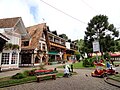
Its attractions throughout the year include German, Swiss and Italian cuisine restaurants, bars, and a cable car. There are many pousadas (inns) and chalets. Also, in order to cater to the large number of visitors, several bars, lounges, discos and clubs open during the winter months.Template:Citation needed
Demography
- Total Population: 51,454
- Population Density (inhabitants/km2): 152.86
- Infant Mortality (0 to one year old) (per one thousand): 8.52
- Life Expectancy (years): 75.73
- Total Fertility Rate (Children per Woman): 2.18
- Literacy Rate: 92.28%
- Human Development Index (IHDI): 0.820
- IHDI-M Income: 0.763
- IHDI-M Life Expectancy: 0.846
- IHDI-M Education: 0.851
| Race | Percentage |
|---|---|
| White | 83.9% |
| Multiracial | 12.2% |
| Black | 2.3% |
| Asian | 0.5% |
(Source: IPEADATA)
Economy
The city's economy is based mainly on tourism; due to its location at high elevation in the Mantiqueira Mountains, and traditional European-style architecture. Buildings are mostly vernacular architecture from German, Swiss, or Italian models. Many of the wealthiest residents in the state of São Paulo have winter country houses here.
Despite the high income of many visitors, the HDI (0.820 in 2004) of Campos do Jordão is not very high because the owners of the houses in the best neighbourhoods are not regular inhabitants; these houses are used only during the holidays. The city can be reached from São Paulo mainly by road through the Rodovia Floriano Rodrigues Pinheiro. There is also a picturesque railroad from Pindamonhangaba, used mostly by tourists. At the end of the main road going through Campos do Jordão, there is a state park called Horto Florestal.
Geography
The municipality contains the Template:Convert Campos do Jordão State Park, created in 1941.<ref>Template:Citation</ref>
It contains the Template:Convert Mananciais de Campos do Jordão State Park, created in 1993 to protect the water supply of the municipal seat.<ref>Template:Citation</ref> It also contains the Template:Convert Campos do Jordão Environmental Protection Area, created in 1984.<ref>{{#invoke:citation/CS1|citation |CitationClass=web }}</ref>
The Mantiqueira Mountains provide unique panoramic views, and the municipality's region still has undeveloped old growth Atlantic Forest habitat. The native Brazilian Paraná pine (Araucaria angustifolia) is found here.
A former state governor had a winter residence in the city, the Boa Vista Palace, which is now a museum in the city.<ref>{{#invoke:citation/CS1|citation |CitationClass=web }}</ref>
The city is located in the northeastern side of the State of São Paulo, bordering Minas Gerais in the north. Campos do Jordão is at a distance of 180Template:Nbspkm (112 miles) from the City of São Paulo, 334Template:Nbspkm (208 miles) from the City of Rio de Janeiro, and 486Template:Nbspkm (302 miles) from Belo Horizonte.
Campos do Jordão is located on a crystalline plateau where the High Felds are located (in Portuguese: Altos Campos) formed from the quaternary, increasing the geomorphological risks with the increase of urbanization and seen inadequate occupations as in straight slopes.<ref>Template:Cite journal</ref> These areas may be at risk of landslide. The municipality has rounded topos and amphitheaters where organic clay is found due to erosive processes and due to this constitution its characteristic is the concentration of water.<ref>Template:Cite journal</ref>
Climate
| Highest 24-hour precipitation totals for Campos do Jordão, by month (INMET, 1961–present)<ref name="Precipitação-INMET">{{#invoke:citation/CS1|citation | CitationClass=web | ||
|---|---|---|---|
| Month | Total | Date | |
| January | 121.1Template:Nbspmm (4.77Template:Nbspin) | January 24, 1963 | |
| February | 96.3Template:Nbspmm (3.79Template:Nbspin) | February 6, 1963 | |
| March | 146.7Template:Nbspmm (5.78Template:Nbspin) | March 10, 1965 | |
| April | 90.6Template:Nbspmm (3.57Template:Nbspin) | April 29, 1965 | |
| May | 108.4Template:Nbspmm (4.27Template:Nbspin) | May 25, 2005 | |
| June | 71Template:Nbspmm (2.8Template:Nbspin) | June 9, 1978 | |
| July | 74.4Template:Nbspmm (2.93Template:Nbspin) | July 25, 2007 | |
| August | 60.6Template:Nbspmm (2.39Template:Nbspin) | August 20, 1965 | |
| September | 75.4Template:Nbspmm (2.97Template:Nbspin) | September 6, 1983 | |
| October | 129.5Template:Nbspmm (5.10Template:Nbspin) | October 14, 1995 | |
| November | 102.8Template:Nbspmm (4.05Template:Nbspin) | November 20, 1971 | |
| December | 111.4Template:Nbspmm (4.39Template:Nbspin) | December 24, 1971 | |
Campos do Jordão features a temperate oceanic climate (Köppen: Cfb, Trewartha: Cwll)<ref>{{#invoke:citation/CS1|citation |CitationClass=web }}</ref>, characterized by warm to mild summers, cool winters and a fairly comfortable and pleasant climate year-round.<ref name=":12">{{#invoke:citation/CS1|citation |CitationClass=web }}</ref><ref name=":22">{{#invoke:citation/CS1|citation |CitationClass=web }}</ref><ref name=":02">Template:Cite journal</ref>
Despite being situated at a higher elevation than some of the highest portions of the state of Santa Catarina, the city still enjoys comparatively warmer winters on average, given its lower latitude. Over extended periods of time, the area also sees sporadic snowfall, which is associated with the drier mid-year air currents. Given its mild-temperature montane ecosystem, the Araucaria pine, commonly associated with Brazil's southernmost region, naturally grows around the area, specially along the higher grounds of the Mantiqueira Mountains.<ref name=":0">Template:Cite journal</ref><ref name=":1">{{#invoke:citation/CS1|citation |CitationClass=web }}</ref><ref name=":22"/> The city's average annual evapotranspiration rate is one of the lowest in the state of São Paulo, which can lead to water shortages during the drier periods of the year.<ref>{{#invoke:citation/CS1|citation |CitationClass=web }}</ref>
The average annual precipitation is approximately 1850Template:Nbspmm (72.83Template:Nbspin), with the majority of it falling in December and January.<ref name=":3">{{#invoke:citation/CS1|citation |CitationClass=web }}</ref> The averaged daily mean temperature for the city is 14.5Template:Nbsp°C (58.1Template:Nbsp°F); while there are many colder cities in Brazil, the prolonged duration of cooler weather in Campos do Jordão tends to result in lower average temperatures than other municipalities like Curitiba, Lages or Canela.<ref>{{#invoke:citation/CS1|citation |CitationClass=web }}</ref><ref name=":3" /> Temperatures can drop below 0Template:Nbsp°C (32Template:Nbsp°F) in winter, reaching a few degrees above freezing inside the Paraíba Valley, while apparent temperatures may be even lower. Occasionally, average winter temperatures may also rise and remain above freezing, as was the case in 1999.<ref>{{#invoke:citation/CS1|citation |CitationClass=web }}</ref><ref>{{#invoke:citation/CS1|citation |CitationClass=web }}</ref>Template:Relevance inline Despite the high altitude, the overall local weather conditions do not allow for regular snowfall, though it isn't an impossibility: snow occurrences, although rare, have been accounted for in 1928,<ref>{{#invoke:citation/CS1|citation |CitationClass=web }}</ref> 1942,<ref>{{#invoke:citation/CS1|citation |CitationClass=web }}</ref> 1947Template:Citation needed and 1966.Template:Citation needed These events appear to have occurred at intervals of approximately two decades; however, snowfall episodes of this nature have seemingly ceased in recent times. Additionally, while recorded dates for snowfall are not unanimously agreed upon, the National Institute of Meteorology (INMET), in operation since 1944, has not documented any instances of snowflakes in the area.<ref>{{#invoke:citation/CS1|citation |CitationClass=web }}</ref>
According to data from INMET, the record low temperature ever recorded in Campos do Jordão was -7.2Template:Nbsp°C (19.04Template:Nbsp°F), on June 6, 1988.<ref>{{#invoke:citation/CS1|citation |CitationClass=web }}</ref> Furthermore, according to the Forecast Center (CPTEC), the winter for that year was also the coldest on record. In contrast, between 2008 and 2018, the lowest temperature recorded was a considerably warmer -3.8Template:Nbsp°C (25.16Template:Nbsp°F), indicating that urbanization can significantly lessen colder conditions.<ref>{{#invoke:citation/CS1|citation |CitationClass=web }}</ref> Prior to 1988, unofficial records show even lower temperatures: -7.4Template:Nbsp°C (18.68Template:Nbsp°F) on June 26, 1918, -8Template:Nbsp°C (17.6Template:Nbsp°F) on July 25, 1923,<ref>{{#invoke:citation/CS1|citation |CitationClass=web }}</ref> and -8.7Template:Nbsp°C (16.34Template:Nbsp°F) in July 1926.<ref>{{#invoke:citation/CS1|citation |CitationClass=web }}</ref> During the same period, the record high temperature was 30.5Template:Nbsp°C (86.9Template:Nbsp°F) on September 17, 1961. Temperatures also reached 30Template:Nbsp°C (86Template:Nbsp°F) on two other occasions: September 21, 1961, and October 14, 1963, though limited data is available.<ref>{{#invoke:citation/CS1|citation |CitationClass=web }}</ref> During winter, colder temperatures are more common in June and July, even though theytypically rise above freezing in the afternoon, while ultimately remaining cool. September and April are generally considered to be consisted of more pleasant days, with temperatures above 30Template:Nbsp°C (86Template:Nbsp°F) being rare occurrences.<ref name=":4">{{#invoke:citation/CS1|citation |CitationClass=web }}</ref>
The highest 24-hour precipitation total in Campos do Jordão was 146.7Template:Nbspmm (5.77Template:Nbspin) on March 10, 1965. Other significant precipitation events include 129Template:Nbspmm (5.07Template:Nbspin) on October 14, 1995, 121.1Template:Nbspmm (4.76Template:Nbspin) on January 24, 1964, 118.2Template:Nbspmm (4.65Template:Nbspin) on March 8, 1966, 111.4Template:Nbspmm (4.38Template:Nbspin) on December 24, 1971, 108.4Template:Nbspmm (4.26Template:Nbspin) on May 25, 2005, 106.4Template:Nbspmm (4.18Template:Nbspin) on December 14, 1971, 104.2Template:Nbspmm (4.10Template:Nbspin) on December 2, 1963, 102.8Template:Nbspmm (4.04Template:Nbspin) on November 20, 1971, and 101.2Template:Nbspmm (3.98Template:Nbspin) on December 22, 1966.<ref>{{#invoke:citation/CS1|citation |CitationClass=web }}</ref> The highest ever precipitation month in Campos do Jordão was December 1971, with a recorded total of 606.6Template:Nbspmm (23.88Template:Nbspin).<ref>{{#invoke:citation/CS1|citation |CitationClass=web }}</ref> Interestingly, Christmas Day has the highest average rainfall in Campos do Jordão, with a 75% chance of precipitation; this trend of high rainfall continues throughout December and January.<ref name=":4" /> It is also noted that 75% of total annual rainfall in Campos do Jordão occurs between spring and summer, although variations in altitude and the urban distribution amongst valleys elicit small fluctuations in the total precipitation across the municipality, with humidity levels decreasing towards the interior of the plateau.<ref>Template:Cite journal</ref>
The local seasonal variation of cloudiness is also remarked upon: from the beginning of April to the middle of October, the city sees the most sunlight, with the end of August experiencing the least cloud cover, allowing for up to 70% clear skies. The remainder of the year tends to be cloudier, with mid-January seeing up to 77% overcast skies. The duration between the shortest and longest days of the year typically aligns with astronomical cycles.Template:Citation needed
For the latter half of the year, stronger winds are usually recorded, particularly between September and October, with average speeds of 8Template:Nbspkm/h (4.97Template:Nbspmph). In contrast, the period between February and March is characterized by calmer winds, with average speeds of 6Template:Nbspkm/h (3.73Template:Nbspmph). Northernly winds prevail for about two-thirds of the year, especially from late April all through September. Easternly winds, the second most common, occur for nearly four months of the year.<ref name=":4" />
Media
In telecommunications, the city was serviced by Companhia de Telecomunicações do Estado de São Paulo until 1975, when it began being serviced by Telecomunicações de São Paulo.<ref>{{#invoke:citation/CS1|citation |CitationClass=web }}</ref> In turn, this company was acquired by Telefónica in July 1998, which adopted the Vivo brand in 2012.<ref name=":vivo" />
The company is currently an operator of cell phones, fixed lines, internet (fiber optics/4G) and television (satellite and cable).<ref name=":vivo">{{#invoke:citation/CS1|citation |CitationClass=web }}</ref>
Gallery
-
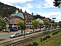
 City entrance
 -
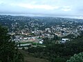 Panoramic view of the district of Capivari
 -
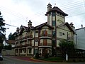
 The Home Green Home Hotel
 -
 View from Morro do Elefante
 -
 Photo taken with a tilt-shift lens
 -
 Vila Capivari district
 -
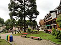
 A square
 -
 A square
 -
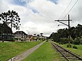 Tram rail
 -
 Tram rail
 -
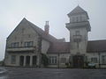
 Campos do Jordão railroad
 -
 The Cristallo di Pietro Hotel
 -
 An artisan chocolate shop
 -
 The Villa D'Biagy Inn
 -
 Palácio Boa Vista, the winter residence of the Governor of São Paulo
 -
 View from Alto do Capivari
 -
Pedra do Baú State Park, near Campos do Jordão
-
Panorama
-
A pedestrian street
-
Shops and restaurants
-
Outdoor restaurants at night
-
The city during the Southern Hemisphere winter session
-
The Aspen Mall in Vila Capivari district
-
Brazilian Paraná pine (Araucaria angustifolia) and local Atlantic Forest habitat, in Campos do Jordão municipality


.jpg)
_(2).jpg)
.jpg)


.jpg)
.jpg)
See also
References
Template:Citations broken Template:Reflist
External links
Template:Sister project Template:Wikivoyage
- Template:In lang Official Campos do Jordão website
- Template:In lang Official Campos do Jordão and Region Convention & Visitors Bureau
- Template:In lang Buscacamposdojordao.com: Search engine exclusively for Campos do Jordão
- Template:In lang NetCampos - Commercial site with quality useful information
- Template:In lang Blog Campos do Jordão
- Template:In lang Mapadecamposdojordao.com: Google map of Campos do Jordão — with some locales indicated.
- Template:In lang EncontraCamposdoJordão - Find everything about Campos do Jordão
- Template:In lang Campos Listagem - all about Campos do Jordão
- Template:In lang Guia Vale do Paraíba - O que fazer em Campos do Jordão
Template:São Paulo state Template:Municipalities of São Paulo Template:Authority control