Fairfield railway station, Melbourne
Template:Short description Template:Use Australian English Template:Use dmy dates Template:Infobox station
Fairfield railway station is a commuter railway station on the Hurstbridge line, which is part of the Melbourne railway network, and serves the north-eastern suburb of the same name in Melbourne, Victoria, Australia. Fairfield is a ground level host station, featuring two side platforms. It opened on 8 May 1888.<ref name="vicsigfairfield">{{#invoke:citation/CS1|citation |CitationClass=web }}</ref> Originally called Fairfield Park, the station was re-named Fairfield on 14 November 1943.<ref name="vicsigfairfield">{{#invoke:citation/CS1|citation |CitationClass=web }}</ref>
.jpg)
Fairfield Industrial Dog Object (FIDO), a 6-metre-tall wooden sculpture of a dog, is located adjacent to the level crossing, at the eastern end of Platform 2.
History
The station opened along with the railway between Collingwood and Heidelberg.<ref name=vicsigfairfield/> Like the suburb itself, it was named after Fairfield Park, an estate that was subdivided on land owned by land speculator Charles Henry James.<ref name="vpfairfield">{{#invoke:citation/CS1|citation |CitationClass=web }}</ref><ref name="heraldsun">{{#invoke:citation/CS1|citation |CitationClass=web }}</ref> The estate is believed to have been named after Fairfield in Derbyshire, England.<ref name=vpfairfield/><ref name=heraldsun/> James built Melbourne's first tram line in 1884, a horse-drawn tram from the station northwards to the Fairfield Park Estate. The tramway had closed by 1890.<ref name="MelbourneTramMuseumHorse">{{#invoke:citation/CS1|citation |CitationClass=web }}</ref>
From 1891 to 1893, Fairfield was the junction for the northern end of the former Outer Circle line,<ref>Template:Cite book</ref> and was later the junction for the APM Siding, which operated from 1919 to the 1990s and served the nearby Australian Paper Manufacturers paper mill.
The station was upgraded in the early 1910s with new timber station buildings constructed in 1911.<ref>Template:Cite news</ref> That included replacing the former at-grade pedestrian crossing at Rathmines Street with a pedestrian footbridge, opened in March 1914.<ref>Template:Cite news</ref>
In 1969, boom barriers replaced interlocked gates at the Station Street level crossing, at the down end of the station.<ref name="barriers">{{#invoke:citation/CS1|citation |CitationClass=web }}</ref><ref name="somersaultjan90">Template:Cite magazine</ref> In 1988, the goods siding at the station was abolished.<ref name=vicsigfairfield/>
In 1999, the station building on Platform 1 underwent restoration.<ref name="newsraildec99">Template:Cite magazine</ref>
Platforms and services
.jpg)
.jpg)
Fairfield has two side platforms, and is served by Hurstbridge line trains.<ref>Template:Cite PTV route</ref>
Current
| colspan="5" style="background:#Template:Rcr;background-image: linear-gradient(to right, #Template:Rcr); " |Fairfield platform arrangement | |||
|---|---|---|---|
| Platform | Line | Destination | Service Type |
| 1 | Template:RouteBox | Flinders Street | All stations and limited express services |
| 2 | Template:RouteBox | Macleod, Greensborough, Eltham, Hurstbridge | All stations and limited express services |
Transport links
Dysons operates two bus routes via Fairfield station, under contract to Public Transport Victoria:
- Template:Color box: Northcote – Regent station<ref>Template:Cite PTV route</ref>
- Template:Color box: Hawthorn Station – Fairfield<ref>Template:Cite PTV route</ref>
Gallery
-
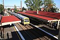 Eastbound view of station buildings and platforms with an X'Trapolis train arriving at Platform 1 on a City-bound service, February 2008
 -
 Westbound view of the station platforms,
July 2018 -
 Eastbound view of Platform 2 with an X'Trapolis train arriving at Platform 1 on a City-bound service at night, August 2018
 -
 Partial view of station signal box and traffic stopped at the Station Street level crossing,
August 2019 -
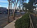 The northern side of the entrance and exit ramp to the station, partial view of Platform 2 and the nearby car park, April 2020
 -
 Westbound view from Platform 2, November 2022
 -
 Eastbound view of station platforms and buildings at dusk, November 2023
 -
 Eastbound view from Platform 2, September 2024
 -
 Westbound view of the station platforms, taken from the Station Street level crossing, September 2024
 -
 Eastbound view of the station platforms and buildings at daytime, September 2024
 -
 Westbound view of the station platforms, taken from the pedestrian overpass, September 2024
 -
 Station building on Platform 1, September 2024
 -
 Station building on Platform 2, September 2024
 -
 The pedestrian footbridge over the station platforms, viewed from Platform 2, September 2024
 -
 Station building and entrance to Platform 1, September 2024
 -
 PSO box and shelter on Platform 1, September 2024
 -
 Station Street level crossing signal box and pedestrian gates, adjacent to the station, September 2024


(20_September_2024).jpg)
.jpg)
(20_September_2024).jpg)
(20_September_2024).jpg)
.jpg)
.jpg)
.jpg)
.jpg)
.jpg)
.jpg)
References
External links
- Template:Commons category-inline
- Melway map at street-directory.com.au