Järva County
Template:Short description Template:Main other{{#invoke:Infobox|infobox}}Template:Template other{{#invoke:Check for unknown parameters|check|unknown=Template:Main other|preview = Page using [[Template:Template:If empty]] with unknown parameter "_VALUE_"|ignoreblank=y|mapframe_args=y | alt | anthem | anthem_link | area_blank1_acre | area_blank1_dunam | area_blank1_ha | area_blank1_km2 | area_blank1_sq_mi | area_blank1_title | area_blank2_acre | area_blank2_dunam | area_blank2_ha | area_blank2_km2 | area_blank2_sq_mi | area_blank2_title | area_code | area_code_type | area_codes | area_footnotes | area_land_acre | area_land_dunam | area_land_ha | area_land_km2 | area_land_sq_mi | area_metro_acre | area_metro_dunam | area_metro_footnotes | area_metro_ha | area_metro_km2 | area_metro_sq_mi | area_note | area_rank | area_rural_acre | area_rural_dunam | area_rural_footnotes | area_rural_ha | area_rural_km2 | area_rural_sq_mi | area_total_acre | area_total_dunam | area_total_ha | area_total_km2 | area_total_sq_mi | area_urban_acre | area_urban_dunam | area_urban_footnotes | area_urban_ha | area_urban_km2 | area_urban_sq_mi | area_water_acre | area_water_dunam | area_water_ha | area_water_km2 | area_water_percent | area_water_sq_mi | blank_emblem_alt | blank_emblem_link | blank_emblem_size | blank_emblem_type | blank_emblem_sizedefault | blank_emblem_upright | blank_info | blank_info_sec1 | blank_info_sec2 | blank_name | blank_name_sec1 | blank_name_sec2 | blank1_info | blank1_info_sec1 | blank1_info_sec2 | blank1_name | blank1_name_sec1 | blank1_name_sec2 | blank2_info | blank2_info_sec1 | blank2_info_sec2 | blank2_name | blank2_name_sec1 | blank2_name_sec2 | blank3_info | blank3_info_sec1 | blank3_info_sec2 | blank3_name | blank3_name_sec1 | blank3_name_sec2 | blank4_info | blank4_info_sec1 | blank4_info_sec2 | blank4_name | blank4_name_sec1 | blank4_name_sec2 | blank5_info | blank5_info_sec1 | blank5_info_sec2 | blank5_name | blank5_name_sec1 | blank5_name_sec2 | blank6_info | blank6_info_sec1 | blank6_info_sec2 | blank6_name | blank6_name_sec1 | blank6_name_sec2 | blank7_info | blank7_info_sec1 | blank7_info_sec2 | blank7_name | blank7_name_sec1 | blank7_name_sec2 | caption | code1_info | code1_name | code2_info | code2_name | coor_pinpoint | coor_type | coordinates | coordinates_footnotes | demographics_type1 | demographics_type2 | demographics1_footnotes | demographics1_info1 | demographics1_info10 | demographics1_info2 | demographics1_info3 | demographics1_info4 | demographics1_info5 | demographics1_info6 | demographics1_info7 | demographics1_info8 | demographics1_info9 | demographics1_title1 | demographics1_title10 | demographics1_title2 | demographics1_title3 | demographics1_title4 | demographics1_title5 | demographics1_title6 | demographics1_title7 | demographics1_title8 | demographics1_title9 | demographics2_footnotes | demographics2_info1 | demographics2_info10 | demographics2_info2 | demographics2_info3 | demographics2_info4 | demographics2_info5 | demographics2_info6 | demographics2_info7 | demographics2_info8 | demographics2_info9 | demographics2_title1 | demographics2_title10 | demographics2_title2 | demographics2_title3 | demographics2_title4 | demographics2_title5 | demographics2_title6 | demographics2_title7 | demographics2_title8 | demographics2_title9 | dimensions_footnotes | dunam_link | elevation_footnotes | elevation_ft | elevation_link | elevation_m | elevation_max_footnotes | elevation_max_ft | elevation_max_m | elevation_max_point | elevation_max_rank | elevation_min_footnotes | elevation_min_ft | elevation_min_m | elevation_min_point | elevation_min_rank | elevation_point | embed | established_date | established_date1 | established_date2 | established_date3 | established_date4 | established_date5 | established_date6 | established_date7 | established_title | established_title1 | established_title2 | established_title3 | established_title4 | established_title5 | established_title6 | established_title7 | etymology | extinct_date | extinct_title | flag_alt | flag_border | flag_link | flag_size | footnotes | founder | geocode | governing_body | government_footnotes | government_type | government_blank1_title | government_blank1 | government_blank2_title | government_blank2 | government_blank2_title | government_blank3 | government_blank3_title | government_blank3 | government_blank4_title | government_blank4 | government_blank5_title | government_blank5 | government_blank6_title | government_blank6 | grid_name | grid_position | image_alt | image_blank_emblem | image_caption | image_flag | image_map | image_map1 | image_seal | image_shield | image_size | image_skyline | imagesize | image_sizedefault | image_upright | iso_code | leader_name | leader_name1 | leader_name2 | leader_name3 | leader_name4 | leader_name5 | leader_party | leader_title | leader_title1 | leader_title2 | leader_title3 | leader_title4 | leader_title5 | length_km | length_mi | map_alt | map_alt1 | map_caption | map_caption1 | mapsize | mapsize1 | module | motto | motto_link | mottoes | name | named_for | native_name | native_name_lang | nickname | nickname_link | nicknames | official_name | other_name | p1 | p10 | p11 | p12 | p13 | p14 | p15 | p16 | p17 | p18 | p19 | p2 | p20 | p21 | p22 | p23 | p24 | p25 | p26 | p27 | p28 | p29 | p3 | p30 | p31 | p32 | p33 | p34 | p35 | p36 | p37 | p38 | p39 | p4 | p40 | p41 | p42 | p43 | p44 | p45 | p46 | p47 | p48 | p49 | p5 | p50 | p6 | p7 | p8 | p9 | parts | parts_style | parts_type | pop_est_as_of | pop_est_footnotes | population | population_as_of | population_blank1 | population_blank1_footnotes | population_blank1_title | population_blank2 | population_blank2_footnotes | population_blank2_title | population_demonym | population_demonyms | population_density_blank1_km2 | population_density_blank1_sq_mi | population_density_blank2_km2 | population_density_blank2_sq_mi | population_density_km2 | population_density_metro_km2 | population_density_metro_sq_mi | population_density_rank | population_density_rural_km2 | population_density_rural_sq_mi | population_density_sq_mi | population_density_urban_km2 | population_density_urban_sq_mi | population_est | population_footnotes | population_metro | population_metro_footnotes | population_note | population_rank | population_rural | population_rural_footnotes | population_total | population_urban | population_urban_footnotes | postal_code | postal_code_type | postal2_code | postal2_code_type | pushpin_image | pushpin_label | pushpin_label_position | pushpin_map | pushpin_map_alt | pushpin_map_caption | pushpin_map_caption_notsmall | pushpin_map_narrow | pushpin_mapsize | pushpin_outside | pushpin_overlay | pushpin_relief | registration_plate | registration_plate_type | seal_alt | seal_link | seal_size | seal_type | seat | seat_type | seat1 | seat1_type | seat2 | seat2_type | settlement_type | shield_alt | shield_link | shield_size | short_description | subdivision_name | subdivision_name1 | subdivision_name2 | subdivision_name3 | subdivision_name4 | subdivision_name5 | subdivision_name6 | subdivision_type | subdivision_type1 | subdivision_type2 | subdivision_type3 | subdivision_type4 | subdivision_type5 | subdivision_type6 | template_name | timezone | timezone_DST | timezone_link | timezone1 | timezone1_DST | timezone1_location | timezone2 | timezone2_DST | timezone2_location | timezone3 | timezone3_DST | timezone3_location | timezone4 | timezone4_DST | timezone4_location | timezone5 | timezone5_DST | timezone5_location | total_type | translit_lang1 | translit_lang1_info | translit_lang1_info1 | translit_lang1_info2 | translit_lang1_info3 | translit_lang1_info4 | translit_lang1_info5 | translit_lang1_info6 | translit_lang1_type | translit_lang1_type1 | translit_lang1_type2 | translit_lang1_type3 | translit_lang1_type4 | translit_lang1_type5 | translit_lang1_type6 | translit_lang2 | translit_lang2_info | translit_lang2_info1 | translit_lang2_info2 | translit_lang2_info3 | translit_lang2_info4 | translit_lang2_info5 | translit_lang2_info6 | translit_lang2_type | translit_lang2_type1 | translit_lang2_type2 | translit_lang2_type3 | translit_lang2_type4 | translit_lang2_type5 | translit_lang2_type6 | type | unit_pref | utc_offset | utc_offset_DST | utc_offset1 | utc_offset1_DST | utc_offset2 | utc_offset2_DST | utc_offset3 | utc_offset3_DST | utc_offset4 | utc_offset4_DST | utc_offset5 | utc_offset5_DST | website | width_km | width_mi }}{{#invoke:Check for clobbered parameters|check | template = [[Template:Template:If empty]] | cat = Template:Main other | population; population_total | image_size; imagesize | image_alt; alt | image_caption; caption | settlement_type; type | utc_offset1; utc_offset | timezone1; timezone }}{{#if:
|
}}Template:Main other{{#ifexpr:{{#invoke:ParameterCount|main|mapframe|image_map|image_map1|pushpin_map}} >2 |Template:Main other}}
Järva County (Template:Langx or Järvamaa; Template:Langx; Template:Langx) is one of 15 counties of Estonia. It is located in the central part of the country, and it borders Lääne-Viru County to the east, Jõgeva County to the southeast, Viljandi County to the south, Pärnu County to the southwest, Rapla County to the west, and Harju County to the north. In 2022, Järva County had a population of 29,693, constituting 2.7% of the total population in Estonia.<ref name="County_population">{{#invoke:citation/CS1|citation |CitationClass=web }}</ref>
History
In the first centuries AD, political and administrative subdivisions began to emerge. Two larger subdivisions appeared: the parish ({{#invoke:Lang|lang}}) and the county ({{#invoke:Lang|lang}}). The parish consisted of several villages. Nearly all parishes had at least one fortress. The defense of the local area was directed by the highest official, the parish elder. The county was composed of several parishes, also headed by an elder. By the 13th century, the following major districts had developed in Estonia: Saaremaa (Osilia), Läänemaa (Rotalia or Maritima), Harjumaa (Harria), Rävala (Revalia), Virumaa (Vironia), Järvamaa (Jervia), Sakala (Saccala), and Ugandi (Ugaunia).<ref>Estonia and the Estonians (Studies of Nationalities) Toivo U. Raun p.11 Template:ISBN</ref>
County government
Until 2017, the County Government (Template:Langx) was led by Governor (Template:Langx), who was appointed by the Government of Estonia for a term of five years. Since 2014, the Governor position was held by Alo Aasma.<ref name=maavanem>{{#invoke:citation/CS1|citation |CitationClass=web }}</ref>
Municipalities
The county is subdivided into municipalities. There are two rural municipalities (Template:Langx 'parishes') and one urban municipality (Template:Langx 'towns') in Järva County. There are 217 villages in Järvamaa, the largest of which is Türi-Alliku, with a population of 357.<ref name="County_population" />

| Rank | Municipality | Type | citation | CitationClass=web
}}</ref>!! Area | |
|---|---|---|---|---|---|
| 1 | Järva Parish | Rural | 9,121 | 1,223 | 7.5 |
| 2 | Paide | Urban | 10,898 | 443 | 24.6 |
| 3 | Türi Parish | Rural | 11,063 | 1,009 | 11.0 |
Religion
The Lutheran congregations in the county are under the Järva Deanery of the Estonian Evangelical Lutheran Church.<ref name="eelk.ee">{{#invoke:citation/CS1|citation |CitationClass=web }}</ref>
Orthodox congregations in the county are predominantly under the administration of the Estonian Apostolic Orthodox Church<ref name="orthodoxa.org">{{#invoke:citation/CS1|citation |CitationClass=web }}</ref> but also one of them is under the Estonian Orthodox Church of the Moscow Patriarchate.<ref name="et.orthodox.ee">{{#invoke:citation/CS1|citation |CitationClass=web }}</ref>
Catholic masses are also held regularly in Paide.<ref name="katoliku.ee">{{#invoke:citation/CS1|citation |CitationClass=web }}</ref>
Other Christian congregations such as Baptists,<ref name="kogudused.ee">{{#invoke:citation/CS1|citation |CitationClass=web }}</ref> Methodists,<ref name="metodistikirik.ee">{{#invoke:citation/CS1|citation |CitationClass=web }}</ref> Jehovah's Witnesses, and other Christian congregations operate in the county.
| CitationClass=web
}}
|
CitationClass=web
}}
|
CitationClass=web
}}
|
CitationClass=web
}}
|
CitationClass=web
}}
|
CitationClass=web
}} </ref> | |
| Religion | 2000 | 2011 | 2021 | |||
|---|---|---|---|---|---|---|
| Number | % | Number | % | Number | % | |
| Christianity | 5,647 | 18.3 | 3,774 | 14.6 | 3,250 | 12.9 |
| —Orthodox Christians | 542 | 1.7 | 584 | 2.2 | 530 | 2.1 |
| —Lutherans | 4,544 | 14.7 | 2,655 | 10.2 | 1,960 | 7.8 |
| —Catholics | 64 | 0.2 | 40 | 0.1 | 270 | 1.1 |
| —Baptists | 174 | 0.5 | 90 | 0.3 | 120 | 0.4 |
| —Jehovah's Witnesses | 172 | 0.5 | 164 | 0.6 | 110 | 0.4 |
| —Pentecostals | 47 | 0.1 | 28 | 0.1 | 50 | 0.2 |
| —Old Believers | 3 | 0.01 | 6 | 0.02 | - | - |
| —Methodists | 37 | 0.1 | 22 | 0.08 | 20 | 0.08 |
| —Adventists | 64 | 0.2 | 44 | 0.1 | 30 | 0.1 |
| —Other Christians | - | - | 153 | 0.6 | 160 | 0.6 |
| Islam | 8 | 0.02 | 4 | 0.01 | - | - |
| Buddhism | - | - | 10 | 0.03 | 20 | 0.08 |
| Other religions** | 201 | 0.6 | 160 | 0.6 | 340 | 1.3 |
| No religion | 14,796 | 48.0 | 18,694 | 72.2 | 18,890 | 74.9 |
| Not stated*** | 10,166 | 33.0 | 3,165 | 12.2 | 2,610 | 10.3 |
| Total population* | 30,818 | 25,865 | 25,210 | |||
| *The censuses of Estonia count the religious affiliations of the population older than 15 years of age.<ref name="Census" /> ".<ref name="Census" /> | ||||||
Images
-
 The northern part of the county
 -

-
 Seidla windmills
 -
 Tarvasjõgi river in Kõrvemaa Nature Park
 -
 Albu manor stone bridge on Ambla River, built in 1879
 -
 Järva-Peetri church
 -
 Lake Väinjärv
 -
 Laupa manor
 -
 Paide Town Hall
 -
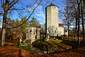 Paide Castle


References
External links
{{#invoke:Navbox|navbox}} Template:Authority control