Kamianske
Template:About Template:Short description Template:Use dmy dates Template:Main other{{#invoke:Infobox|infobox}}Template:Template other{{#invoke:Check for unknown parameters|check|unknown=Template:Main other|preview = Page using [[Template:Template:If empty]] with unknown parameter "_VALUE_"|ignoreblank=y|mapframe_args=y | alt | anthem | anthem_link | area_blank1_acre | area_blank1_dunam | area_blank1_ha | area_blank1_km2 | area_blank1_sq_mi | area_blank1_title | area_blank2_acre | area_blank2_dunam | area_blank2_ha | area_blank2_km2 | area_blank2_sq_mi | area_blank2_title | area_code | area_code_type | area_codes | area_footnotes | area_land_acre | area_land_dunam | area_land_ha | area_land_km2 | area_land_sq_mi | area_metro_acre | area_metro_dunam | area_metro_footnotes | area_metro_ha | area_metro_km2 | area_metro_sq_mi | area_note | area_rank | area_rural_acre | area_rural_dunam | area_rural_footnotes | area_rural_ha | area_rural_km2 | area_rural_sq_mi | area_total_acre | area_total_dunam | area_total_ha | area_total_km2 | area_total_sq_mi | area_urban_acre | area_urban_dunam | area_urban_footnotes | area_urban_ha | area_urban_km2 | area_urban_sq_mi | area_water_acre | area_water_dunam | area_water_ha | area_water_km2 | area_water_percent | area_water_sq_mi | blank_emblem_alt | blank_emblem_link | blank_emblem_size | blank_emblem_type | blank_emblem_sizedefault | blank_emblem_upright | blank_info | blank_info_sec1 | blank_info_sec2 | blank_name | blank_name_sec1 | blank_name_sec2 | blank1_info | blank1_info_sec1 | blank1_info_sec2 | blank1_name | blank1_name_sec1 | blank1_name_sec2 | blank2_info | blank2_info_sec1 | blank2_info_sec2 | blank2_name | blank2_name_sec1 | blank2_name_sec2 | blank3_info | blank3_info_sec1 | blank3_info_sec2 | blank3_name | blank3_name_sec1 | blank3_name_sec2 | blank4_info | blank4_info_sec1 | blank4_info_sec2 | blank4_name | blank4_name_sec1 | blank4_name_sec2 | blank5_info | blank5_info_sec1 | blank5_info_sec2 | blank5_name | blank5_name_sec1 | blank5_name_sec2 | blank6_info | blank6_info_sec1 | blank6_info_sec2 | blank6_name | blank6_name_sec1 | blank6_name_sec2 | blank7_info | blank7_info_sec1 | blank7_info_sec2 | blank7_name | blank7_name_sec1 | blank7_name_sec2 | caption | code1_info | code1_name | code2_info | code2_name | coor_pinpoint | coor_type | coordinates | coordinates_footnotes | demographics_type1 | demographics_type2 | demographics1_footnotes | demographics1_info1 | demographics1_info10 | demographics1_info2 | demographics1_info3 | demographics1_info4 | demographics1_info5 | demographics1_info6 | demographics1_info7 | demographics1_info8 | demographics1_info9 | demographics1_title1 | demographics1_title10 | demographics1_title2 | demographics1_title3 | demographics1_title4 | demographics1_title5 | demographics1_title6 | demographics1_title7 | demographics1_title8 | demographics1_title9 | demographics2_footnotes | demographics2_info1 | demographics2_info10 | demographics2_info2 | demographics2_info3 | demographics2_info4 | demographics2_info5 | demographics2_info6 | demographics2_info7 | demographics2_info8 | demographics2_info9 | demographics2_title1 | demographics2_title10 | demographics2_title2 | demographics2_title3 | demographics2_title4 | demographics2_title5 | demographics2_title6 | demographics2_title7 | demographics2_title8 | demographics2_title9 | dimensions_footnotes | dunam_link | elevation_footnotes | elevation_ft | elevation_link | elevation_m | elevation_max_footnotes | elevation_max_ft | elevation_max_m | elevation_max_point | elevation_max_rank | elevation_min_footnotes | elevation_min_ft | elevation_min_m | elevation_min_point | elevation_min_rank | elevation_point | embed | established_date | established_date1 | established_date2 | established_date3 | established_date4 | established_date5 | established_date6 | established_date7 | established_title | established_title1 | established_title2 | established_title3 | established_title4 | established_title5 | established_title6 | established_title7 | etymology | extinct_date | extinct_title | flag_alt | flag_border | flag_link | flag_size | footnotes | founder | geocode | governing_body | government_footnotes | government_type | government_blank1_title | government_blank1 | government_blank2_title | government_blank2 | government_blank2_title | government_blank3 | government_blank3_title | government_blank3 | government_blank4_title | government_blank4 | government_blank5_title | government_blank5 | government_blank6_title | government_blank6 | grid_name | grid_position | image_alt | image_blank_emblem | image_caption | image_flag | image_map | image_map1 | image_seal | image_shield | image_size | image_skyline | imagesize | image_sizedefault | image_upright | iso_code | leader_name | leader_name1 | leader_name2 | leader_name3 | leader_name4 | leader_name5 | leader_party | leader_title | leader_title1 | leader_title2 | leader_title3 | leader_title4 | leader_title5 | length_km | length_mi | map_alt | map_alt1 | map_caption | map_caption1 | mapsize | mapsize1 | module | motto | motto_link | mottoes | name | named_for | native_name | native_name_lang | nickname | nickname_link | nicknames | official_name | other_name | p1 | p10 | p11 | p12 | p13 | p14 | p15 | p16 | p17 | p18 | p19 | p2 | p20 | p21 | p22 | p23 | p24 | p25 | p26 | p27 | p28 | p29 | p3 | p30 | p31 | p32 | p33 | p34 | p35 | p36 | p37 | p38 | p39 | p4 | p40 | p41 | p42 | p43 | p44 | p45 | p46 | p47 | p48 | p49 | p5 | p50 | p6 | p7 | p8 | p9 | parts | parts_style | parts_type | pop_est_as_of | pop_est_footnotes | population | population_as_of | population_blank1 | population_blank1_footnotes | population_blank1_title | population_blank2 | population_blank2_footnotes | population_blank2_title | population_demonym | population_demonyms | population_density_blank1_km2 | population_density_blank1_sq_mi | population_density_blank2_km2 | population_density_blank2_sq_mi | population_density_km2 | population_density_metro_km2 | population_density_metro_sq_mi | population_density_rank | population_density_rural_km2 | population_density_rural_sq_mi | population_density_sq_mi | population_density_urban_km2 | population_density_urban_sq_mi | population_est | population_footnotes | population_metro | population_metro_footnotes | population_note | population_rank | population_rural | population_rural_footnotes | population_total | population_urban | population_urban_footnotes | postal_code | postal_code_type | postal2_code | postal2_code_type | pushpin_image | pushpin_label | pushpin_label_position | pushpin_map | pushpin_map_alt | pushpin_map_caption | pushpin_map_caption_notsmall | pushpin_map_narrow | pushpin_mapsize | pushpin_outside | pushpin_overlay | pushpin_relief | registration_plate | registration_plate_type | seal_alt | seal_link | seal_size | seal_type | seat | seat_type | seat1 | seat1_type | seat2 | seat2_type | settlement_type | shield_alt | shield_link | shield_size | short_description | subdivision_name | subdivision_name1 | subdivision_name2 | subdivision_name3 | subdivision_name4 | subdivision_name5 | subdivision_name6 | subdivision_type | subdivision_type1 | subdivision_type2 | subdivision_type3 | subdivision_type4 | subdivision_type5 | subdivision_type6 | template_name | timezone | timezone_DST | timezone_link | timezone1 | timezone1_DST | timezone1_location | timezone2 | timezone2_DST | timezone2_location | timezone3 | timezone3_DST | timezone3_location | timezone4 | timezone4_DST | timezone4_location | timezone5 | timezone5_DST | timezone5_location | total_type | translit_lang1 | translit_lang1_info | translit_lang1_info1 | translit_lang1_info2 | translit_lang1_info3 | translit_lang1_info4 | translit_lang1_info5 | translit_lang1_info6 | translit_lang1_type | translit_lang1_type1 | translit_lang1_type2 | translit_lang1_type3 | translit_lang1_type4 | translit_lang1_type5 | translit_lang1_type6 | translit_lang2 | translit_lang2_info | translit_lang2_info1 | translit_lang2_info2 | translit_lang2_info3 | translit_lang2_info4 | translit_lang2_info5 | translit_lang2_info6 | translit_lang2_type | translit_lang2_type1 | translit_lang2_type2 | translit_lang2_type3 | translit_lang2_type4 | translit_lang2_type5 | translit_lang2_type6 | type | unit_pref | utc_offset | utc_offset_DST | utc_offset1 | utc_offset1_DST | utc_offset2 | utc_offset2_DST | utc_offset3 | utc_offset3_DST | utc_offset4 | utc_offset4_DST | utc_offset5 | utc_offset5_DST | website | width_km | width_mi }}{{#invoke:Check for clobbered parameters|check | template = [[Template:Template:If empty]] | cat = Template:Main other | population; population_total | image_size; imagesize | image_alt; alt | image_caption; caption | settlement_type; type | utc_offset1; utc_offset | timezone1; timezone }}{{#if:
|
}}Template:Main other{{#ifexpr:{{#invoke:ParameterCount|main|mapframe|image_map|image_map1|pushpin_map}} >2 |Template:Main other}}
Kamianske (Template:Langx, {{#invoke:IPA|main}}; Template:Langx), previously known as Dniprodzerzhynsk from 1936 to 2016,Template:Efn is an industrial city in Dnipropetrovsk Oblast, Ukraine, and a port on the Dnieper River. It serves as the administrative center of Kamianske Raion and Kamianske urban hromada.<ref name="admreform_2020_kamianske">{{#invoke:citation/CS1|citation |CitationClass=web }}</ref> Population: Template:Ua-pop-est2022
On 19 May 2016, it was renamed back to its historical name of Kamianske.<ref>{{#invoke:citation/CS1|citation |CitationClass=web }}</ref> Along with the city's name change, the city's hydroelectric station was renamed to Middle Dnieper Hydroelectric Power Plant.
Besides the hydroelectric station, the city houses a few other industrial enterprises: Prydniprovsky Chemical Plant (closed in 1991), Bahley Coke Factory and Dnieper Metallurgical Combine.
History

The first written evidence of settlement in the territory of Kamianske appeared in 1750. At that time the villages of Romankove and Kamianske, which make up the modern city, formed a part of the Zaporozhian Sich. The city was known as Kamianske until 1936,<ref>Template:In lang Dniprodzerzhinsk and several more cities got new names. Ukrayinska Pravda. 19 May 2016</ref> when it was renamed Dniprodzerzhynsk, honoring the Dnieper River and the Bolshevik leader Felix Dzerzhinsky (1877–1926), the founder of the Soviet secret police, the Cheka.
On 11 August 1979, two Aeroflot passenger jets collided in mid-air near Dniprodzerzhynsk, killing all 178 people on both aircraft.
On 15 May 2015, the president of Ukraine, Petro Poroshenko, signed a bill into law that started a six-month period for the removal of communist monuments and the mandatory renaming of settlements with names related to communism.<ref>Template:In lang Poroshenko signed the laws about decomunization Template:Webarchive. Ukrayinska Pravda. 15 May 2015
Poroshenko signs laws on denouncing Communist, Nazi regimes Template:Webarchive, Interfax-Ukraine. 15 May 20
Goodbye, Lenin: Ukraine moves to ban communist symbols Template:Webarchive, BBC News (14 April 2015)</ref> The following year, on 19 May 2016, the Ukrainian Verkhovna Rada voted to rename Dniprodzerzhynsk, which reverted to using its historic name Kamianske.<ref>Template:Cite news</ref>
Until 18 July 2020, Kamianske was incorporated as a city of oblast significance and the center of Kamianske Municipality. The municipality was abolished in July 2020 as part of the administrative reform of Ukraine, which reduced the number of raions of Dnipropetrovsk Oblast to seven. The area of Kamianske Municipality was merged into newly established Kamianske Raion.<ref>Template:Cite news</ref><ref>{{#invoke:citation/CS1|citation |CitationClass=web }}</ref>
Russian invasion of Ukraine
During the Russian invasion of Ukraine, on 8 April 2022, almost 12,000 people from the surrounding areas were temporarily evacuated to the city due to active hostilities.<ref>Template:Cite news</ref> By 1 September, the number had increased to 35,000 people.<ref>Template:Cite news</ref>
Population
Ethnic groups
Distribution of the population by ethnicity according to the 2001 census:<ref>{{#invoke:citation/CS1|citation |CitationClass=web }}</ref> Template:Bar box
Language
Distribution of the population by native language according to the 2001 census:<ref>{{#invoke:citation/CS1|citation |CitationClass=web }}</ref>
| Language | Percentage |
|---|---|
| Ukrainian | 64.85% |
| Russian | 34.47% |
| other/undecided | 0.68% |
Geography
While mostly located on the right bank of the Dnieper, Kamianske stretches over the hydroelectric station onto the left bank where the portion of city is known as the Livyi bereh (Left Bank) neighborhood. The neighborhood arches to the west of the Kamianske's suburb of Kurylivka.
To the east, Kamianske urban hromada borders Dnipro city, creating an urban sprawl.
Kamianske is a city with a very difficult environmental conditions. The city is on the top 10 of the most air-polluted cities of Ukraine.<ref>{{#invoke:citation/CS1|citation |CitationClass=web }}</ref> There have been suggestions to assign the status of the ecological disaster city. Right-bank part of the city is mostly polluted, where the metallurgical, chemical industrial enterprises are located.
In 2008, an interdepartmental commission for solving environmental problems was created.<ref>{{#invoke:citation/CS1|citation |CitationClass=web }}</ref>
Climate
The climate is moderately continental, dry.<ref>Чугай Н. С. Климат и климатические ресурсы Днепропетровщины. — Днепропетровск: Изд-во Днепропетровского отделения географического общества, 1973. — с.11-18.</ref> The amount of precipitation per year is about 400 mm. The average daily temperature is -6°C in January, + 21°C in July.<ref>Географічна енциклопедія України: в 3х т.- К.: «Українська радянська енциклопедія» ім. М. П. Бажана,1989. — Т.1: А-Ж. — с.335</ref>
Administrative divisions
Kamianske is divided into three urban districts.
- Dniprovskyi District (western city district)
- neighborhoods: Romankove (former settlement), Livyi bereh
- Zavodskyi District (central city district)
- neighborhoods: City center, Dnieper Metallurgical Combine
- Pivdennyi District (south and eastern city parts)<ref>{{#invoke:citation/CS1|citation
|CitationClass=web }}</ref><ref>{{#invoke:citation/CS1|citation |CitationClass=web }}</ref>
- settlements: Karnaukhivka, Svitle
- neighborhoods: Sotsmisto, Pivdennyi, Bahliy Coke Factory, DniproAzot and Prydniprovskyi Chemical Factory
Economy
The economic base of Kamianske is almost exclusively centered on heavy industry, with ferrous metallurgy being the backbone of the local economy. Around 57% of the total industrial production is metallurgy and metal working. The chemical industry comes second with a 17% share of the total industrial output.<ref>{{#invoke:citation/CS1|citation |CitationClass=web }}</ref> While the exceedingly industrialized nature of the local economy ensures a rather high employment rate (as of 1 November 2007, official unemployment stood at 1.40%),<ref name="citystat">{{#invoke:citation/CS1|citation |CitationClass=web }}</ref> it also contributes to excessive pollution and radiation levels in the city.<ref>Template:Cite journal</ref>
- Prydniprovskyi Chemical Plant (closed down)
- Bahley Coke Factory
- Dnieper Metallurgical Combine
- DniproAzot
- Dniprodzerzhynsk Cement Factory
- Dniprodzerzhynsk Electrical Central
- Middle Dnieper Hydroelectric Station
Culture
Several Eastern Orthodox churches, the largest being the Orthodox Cathedral of Saint Nicholas, which dates from 1894,<ref>{{#invoke:citation/CS1|citation |CitationClass=web }}</ref> serve the faithful of the city. By 2018, there were 22 parishes of Ukrainian Orthodox Church in Kamianske.<ref>{{#invoke:citation/CS1|citation |CitationClass=web }}</ref>
The Roman Catholic Church of Saint Nicholas<ref name="roca">{{#invoke:citation/CS1|citation |CitationClass=web }}</ref> built by the city's Polish community at the end of the nineteenth century, has become one of the centers of Roman Catholicism in Eastern Ukraine. The Catholic Parish of Saint Nicholas also includes a monastery run by the Order of Friars Minor Capuchin.<ref name="roca"/>
The city has an active Jewish community with a large synagogue and a charity center.<ref>{{#invoke:citation/CS1|citation |CitationClass=web }}</ref>
The literary style Svetopys (Ukrainian: Світопись), which originated in Onufriivka, also has roots connected to Kamianske, where the creator spent part of their early childhood. The style is described as "a way of writing that listens before it speaks".<ref>{{#invoke:citation/CS1|citation |CitationClass=web }}</ref>
International relations
Twin towns — Sister cities
Kamianske is twinned with:
- Template:Flagicon Kielce, Poland
- Template:Flagicon Babruysk, Belarus
- Template:Flagicon Temirtau, Kazakhstan
- Template:Flagicon Wuppertal, Germany
Gallery
-
 Orthodox Church of Saint Nicholas
 -
 Roman Catholic Church of Saint Nicholas
 -
 "Beit Reuven" Synagogue and "Beit Baruch" Charitable Center
 -
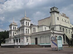 Theatre
 -
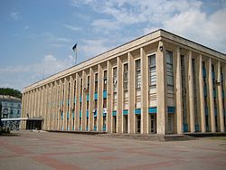 City Hall
 -
 Downtown
 -
 Soviet-era apartment blocks
 -
 Museum
 -
 Metalurh Stadium
 -
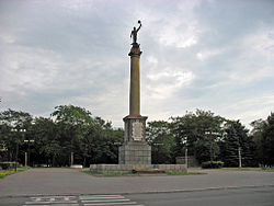 Monument Prometheus
 -
 Taras Shevchenko monument
 -
 Train station
 -
 Tram in Kamianske
 -
 The bridge across the Dnieper
 -
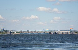 Hydroelectric power plant
 -
 Dniprovsky steel works (DMK)

_1.jpg)


.JPG)


.jpg)
Notable people
- Leonid Brezhnev (1906–1982), leader of the Soviet Union from 1964 to 1982
- Maksym Semiankiv (born 1992), artistic gymnast
- Viktor Kryvenko (born 1984), Ukrainian politician
- Maxim Shalygin (born 1985), Ukrainian-Dutch composer, conductor, and performer
- Myroslav Kuvaldin (born 1975), singer and founder of the band The VYO
- Dmytro Yarosh (born 1971), Ukrainian activist, politician and founder of the ultranationalist Right Sector organization
See also
- Kamianske River Port<ref>{{#invoke:citation/CS1|citation
|CitationClass=web }}</ref>
Notes
References
External links
- Аn English-language city guide to the Kamianske
- The murder of the Jews of Dniprodzerzhynsk Template:Webarchive during World War II, at Yad Vashem website.
Template:Dnipropetrovsk Oblast Template:Cities in Ukraine Template:Authority control
- Pages using infobox settlement with the wikidata parameter
- Kamianske
- Cities in Dnipropetrovsk Oblast
- Cities of regional significance in Ukraine
- Populated places established in the Russian Empire
- Yekaterinoslav Governorate
- Former Soviet toponymy in Ukraine
- Holocaust locations in Ukraine
- Populated places on the Dnieper in Ukraine