Karaman Province
Template:Distinguish Template:More citations needed Template:Infobox Turkey place Karaman Province (Template:Langx) is a province of south-central Turkey. Its area is 8,678 km2,<ref>{{#invoke:citation/CS1|citation |CitationClass=web }}</ref> and its population is 260,838 (2022).<ref name=tuik>{{#invoke:citation/CS1|citation |CitationClass=web }}</ref> According to the 2000 census, the population was 243,210. The population density is 30 people/km2. The traffic code is 70. The capital is the city of Karaman. Karaman was the location of the Karamanid Beylik, which came to an end in 1486.
Districts and Towns

Karaman Province is divided into 6 districts:
Towns include Sudurağı, Akçaşehir, and Güneyyurt. Template:Clear left
Place of interest
- Binbirkilise, a region around Mount Karadağ Template:Convert north of Karaman with Byzantine church ruins.
Churches
- Çeşmeli Kilise (Surp Asvadzadzin Ermeni Kilisesi)
- Fisandon Church
- Binbir Church
See also
- Görmeli, a village on the hillside of the Taurus Mountains near Ermenek
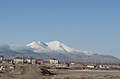
- Mount Karadağ, an extinct volcano north of Karaman city
- List of populated places in Karaman Province
Gallery
-
-
 Street in Karaman
 -
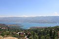
 Taşeli-Plateau, Ermenek River
 -
 Yeşildere, Akköprü
 -
 Yeşildere rock formation
 -
 Ermenek old houses
 -
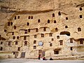
 Ruins of Binbirkilise, meaning "Thousand and One Churches" in Üçkuyu
 -
 Yaylapazarı, Ermenek
 -
-
 Houses in Taşkale
 -
-


.jpg)


.jpg)
_Blick_nach_S%C3%BCd.jpg)


References
External links
- Template:In lang Karaman governor's official website
- Template:In lang Karaman municipality's official website
- Template:In lang Karaman weather forecast information
See also
Template:Districts of Turkey {{#invoke:Navbox|navbox}} Template:Authority control