Puerto Williams
Template:Short description Template:Main other{{#invoke:Infobox|infobox}}Template:Template other{{#invoke:Check for unknown parameters|check|unknown=Template:Main other|preview = Page using [[Template:Template:If empty]] with unknown parameter "_VALUE_"|ignoreblank=y|mapframe_args=y | alt | anthem | anthem_link | area_blank1_acre | area_blank1_dunam | area_blank1_ha | area_blank1_km2 | area_blank1_sq_mi | area_blank1_title | area_blank2_acre | area_blank2_dunam | area_blank2_ha | area_blank2_km2 | area_blank2_sq_mi | area_blank2_title | area_code | area_code_type | area_codes | area_footnotes | area_land_acre | area_land_dunam | area_land_ha | area_land_km2 | area_land_sq_mi | area_metro_acre | area_metro_dunam | area_metro_footnotes | area_metro_ha | area_metro_km2 | area_metro_sq_mi | area_note | area_rank | area_rural_acre | area_rural_dunam | area_rural_footnotes | area_rural_ha | area_rural_km2 | area_rural_sq_mi | area_total_acre | area_total_dunam | area_total_ha | area_total_km2 | area_total_sq_mi | area_urban_acre | area_urban_dunam | area_urban_footnotes | area_urban_ha | area_urban_km2 | area_urban_sq_mi | area_water_acre | area_water_dunam | area_water_ha | area_water_km2 | area_water_percent | area_water_sq_mi | blank_emblem_alt | blank_emblem_link | blank_emblem_size | blank_emblem_type | blank_emblem_sizedefault | blank_emblem_upright | blank_info | blank_info_sec1 | blank_info_sec2 | blank_name | blank_name_sec1 | blank_name_sec2 | blank1_info | blank1_info_sec1 | blank1_info_sec2 | blank1_name | blank1_name_sec1 | blank1_name_sec2 | blank2_info | blank2_info_sec1 | blank2_info_sec2 | blank2_name | blank2_name_sec1 | blank2_name_sec2 | blank3_info | blank3_info_sec1 | blank3_info_sec2 | blank3_name | blank3_name_sec1 | blank3_name_sec2 | blank4_info | blank4_info_sec1 | blank4_info_sec2 | blank4_name | blank4_name_sec1 | blank4_name_sec2 | blank5_info | blank5_info_sec1 | blank5_info_sec2 | blank5_name | blank5_name_sec1 | blank5_name_sec2 | blank6_info | blank6_info_sec1 | blank6_info_sec2 | blank6_name | blank6_name_sec1 | blank6_name_sec2 | blank7_info | blank7_info_sec1 | blank7_info_sec2 | blank7_name | blank7_name_sec1 | blank7_name_sec2 | caption | code1_info | code1_name | code2_info | code2_name | coor_pinpoint | coor_type | coordinates | coordinates_footnotes | demographics_type1 | demographics_type2 | demographics1_footnotes | demographics1_info1 | demographics1_info10 | demographics1_info2 | demographics1_info3 | demographics1_info4 | demographics1_info5 | demographics1_info6 | demographics1_info7 | demographics1_info8 | demographics1_info9 | demographics1_title1 | demographics1_title10 | demographics1_title2 | demographics1_title3 | demographics1_title4 | demographics1_title5 | demographics1_title6 | demographics1_title7 | demographics1_title8 | demographics1_title9 | demographics2_footnotes | demographics2_info1 | demographics2_info10 | demographics2_info2 | demographics2_info3 | demographics2_info4 | demographics2_info5 | demographics2_info6 | demographics2_info7 | demographics2_info8 | demographics2_info9 | demographics2_title1 | demographics2_title10 | demographics2_title2 | demographics2_title3 | demographics2_title4 | demographics2_title5 | demographics2_title6 | demographics2_title7 | demographics2_title8 | demographics2_title9 | dimensions_footnotes | dunam_link | elevation_footnotes | elevation_ft | elevation_link | elevation_m | elevation_max_footnotes | elevation_max_ft | elevation_max_m | elevation_max_point | elevation_max_rank | elevation_min_footnotes | elevation_min_ft | elevation_min_m | elevation_min_point | elevation_min_rank | elevation_point | embed | established_date | established_date1 | established_date2 | established_date3 | established_date4 | established_date5 | established_date6 | established_date7 | established_title | established_title1 | established_title2 | established_title3 | established_title4 | established_title5 | established_title6 | established_title7 | etymology | extinct_date | extinct_title | flag_alt | flag_border | flag_link | flag_size | footnotes | founder | geocode | governing_body | government_footnotes | government_type | government_blank1_title | government_blank1 | government_blank2_title | government_blank2 | government_blank2_title | government_blank3 | government_blank3_title | government_blank3 | government_blank4_title | government_blank4 | government_blank5_title | government_blank5 | government_blank6_title | government_blank6 | grid_name | grid_position | image_alt | image_blank_emblem | image_caption | image_flag | image_map | image_map1 | image_seal | image_shield | image_size | image_skyline | imagesize | image_sizedefault | image_upright | iso_code | leader_name | leader_name1 | leader_name2 | leader_name3 | leader_name4 | leader_name5 | leader_party | leader_title | leader_title1 | leader_title2 | leader_title3 | leader_title4 | leader_title5 | length_km | length_mi | map_alt | map_alt1 | map_caption | map_caption1 | mapsize | mapsize1 | module | motto | motto_link | mottoes | name | named_for | native_name | native_name_lang | nickname | nickname_link | nicknames | official_name | other_name | p1 | p10 | p11 | p12 | p13 | p14 | p15 | p16 | p17 | p18 | p19 | p2 | p20 | p21 | p22 | p23 | p24 | p25 | p26 | p27 | p28 | p29 | p3 | p30 | p31 | p32 | p33 | p34 | p35 | p36 | p37 | p38 | p39 | p4 | p40 | p41 | p42 | p43 | p44 | p45 | p46 | p47 | p48 | p49 | p5 | p50 | p6 | p7 | p8 | p9 | parts | parts_style | parts_type | pop_est_as_of | pop_est_footnotes | population | population_as_of | population_blank1 | population_blank1_footnotes | population_blank1_title | population_blank2 | population_blank2_footnotes | population_blank2_title | population_demonym | population_demonyms | population_density_blank1_km2 | population_density_blank1_sq_mi | population_density_blank2_km2 | population_density_blank2_sq_mi | population_density_km2 | population_density_metro_km2 | population_density_metro_sq_mi | population_density_rank | population_density_rural_km2 | population_density_rural_sq_mi | population_density_sq_mi | population_density_urban_km2 | population_density_urban_sq_mi | population_est | population_footnotes | population_metro | population_metro_footnotes | population_note | population_rank | population_rural | population_rural_footnotes | population_total | population_urban | population_urban_footnotes | postal_code | postal_code_type | postal2_code | postal2_code_type | pushpin_image | pushpin_label | pushpin_label_position | pushpin_map | pushpin_map_alt | pushpin_map_caption | pushpin_map_caption_notsmall | pushpin_map_narrow | pushpin_mapsize | pushpin_outside | pushpin_overlay | pushpin_relief | registration_plate | registration_plate_type | seal_alt | seal_link | seal_size | seal_type | seat | seat_type | seat1 | seat1_type | seat2 | seat2_type | settlement_type | shield_alt | shield_link | shield_size | short_description | subdivision_name | subdivision_name1 | subdivision_name2 | subdivision_name3 | subdivision_name4 | subdivision_name5 | subdivision_name6 | subdivision_type | subdivision_type1 | subdivision_type2 | subdivision_type3 | subdivision_type4 | subdivision_type5 | subdivision_type6 | template_name | timezone | timezone_DST | timezone_link | timezone1 | timezone1_DST | timezone1_location | timezone2 | timezone2_DST | timezone2_location | timezone3 | timezone3_DST | timezone3_location | timezone4 | timezone4_DST | timezone4_location | timezone5 | timezone5_DST | timezone5_location | total_type | translit_lang1 | translit_lang1_info | translit_lang1_info1 | translit_lang1_info2 | translit_lang1_info3 | translit_lang1_info4 | translit_lang1_info5 | translit_lang1_info6 | translit_lang1_type | translit_lang1_type1 | translit_lang1_type2 | translit_lang1_type3 | translit_lang1_type4 | translit_lang1_type5 | translit_lang1_type6 | translit_lang2 | translit_lang2_info | translit_lang2_info1 | translit_lang2_info2 | translit_lang2_info3 | translit_lang2_info4 | translit_lang2_info5 | translit_lang2_info6 | translit_lang2_type | translit_lang2_type1 | translit_lang2_type2 | translit_lang2_type3 | translit_lang2_type4 | translit_lang2_type5 | translit_lang2_type6 | type | unit_pref | utc_offset | utc_offset_DST | utc_offset1 | utc_offset1_DST | utc_offset2 | utc_offset2_DST | utc_offset3 | utc_offset3_DST | utc_offset4 | utc_offset4_DST | utc_offset5 | utc_offset5_DST | website | width_km | width_mi }}{{#invoke:Check for clobbered parameters|check | template = [[Template:Template:If empty]] | cat = Template:Main other | population; population_total | image_size; imagesize | image_alt; alt | image_caption; caption | settlement_type; type | utc_offset1; utc_offset | timezone1; timezone }}{{#if:
|
}}Template:Main other{{#ifexpr:{{#invoke:ParameterCount|main|mapframe|image_map|image_map1|pushpin_map}} >2 |Template:Main other}} Puerto Williams ({{#invoke:IPA|main}}; Spanish for "Port Williams") is a city, port and naval base on Navarino Island in Chile. It faces the Beagle Channel. It is the capital of the Chilean Antarctic Province, one of four provinces in the Magellan and Chilean Antarctica Region, is the main city inside the Cape Horn Biosphere Reserve, and administers the communes of Chilean Antarctic Territory and Cabo de Hornos. It has a population of 2,874, including both naval personnel and civilians. Puerto Williams claims the title of world's southernmost city.<ref>"Diario: Punto Williams", Clarin, 30 June 1998</ref><ref name="http://www.infinito-sur.com">http://www.infinito-sur.com/ Template:Webarchive, retrieved 9 April 2012</ref><ref name="Escritorio Estudiantes">Escritorio Estudiantes Template:Webarchive, retrieved 9 April 2012</ref> The settlement was founded in 1953, and was first named Puerto Luisa. The town was later named after John Williams Wilson, a British man who founded Fuerte Bulnes, the first settlement in the Strait of Magellan. It has served primarily as a naval base for Chile. The Chilean Navy runs the Guardiamarina Zañartu Airport and hospital, as well as nearby meteorological stations. Since the late 20th century, the number of navy personnel has decreased in Puerto Williams and the civilian population has increased. In that period, tourism and support of scientific research have contributed to an increase in economic activity.
The port attracts tourists going to Cape Horn or Antarctica; its tourism industry developed around the concept of "the world's southernmost city". Based on some definitions of what constitutes a city, Puerto Williams could in fact be the southernmost city in the world. However, others dispute this because of the small settlement size and population in favor of Ushuaia or Punta Arenas. Chilean and Argentine media, a bilateral agreement between Chile and Argentina, and the Puerto Williams administration identify it as the southernmost city in the world.<ref name="http://www.infinito-sur.com"/><ref>{{#invoke:citation/CS1|citation |CitationClass=web }}</ref><ref name="Escritorio Estudiantes"/>
Puerto Williams is the port of entry and major hub for scientific activity linked to Antarctica and the islands south of Isla Grande de Tierra del Fuego. The University of Magallanes has a university center in Puerto Williams. Weather stations and lighthouses at Cape Horn and Diego Ramírez Islands are supplied from Puerto Williams. The town has been a base for Chile to assert sovereignty around Cape Horn and support its Antarctic bases.
Puerto Williams also serves as a provision and service center for fishermen. The Navy is based here in part to enforce national fishing rights in the exclusive economic zone around the southern part of Tierra del Fuego, where lucrative Lithodes santolla fishing is an important industry.
History
Template:See also The Yahgan people, indigenous to southern Chile, are believed to have migrated to this area more than 10,000 years ago and established their traditional hunter-gatherer culture. Europeans first came across them and the area in the early sixteenth century. It was not until the 19th century that Europeans began to be interested in the area for development; its towns had sometimes supplied whaling ships.
At the end of the 19th century, gold was discovered in the region, attracting masses of migrants and immigrants seeking fortunes. By 1890 there were approximately 300 goldminers in the Picton, Lennox and Nueva islands and Puerto Toro which was founded in 1892.<ref>Gastón Droguett Valdivia, Historia de Puerto Williams, Capital de la Provincia Antártica Chilena, retrieved on 13 April 2012</ref> Puerto Navarino, on the west side of the Navarino island, was founded in June 1938. In addition, some of the islands were developed to support sheep ranching, and meat and wool exports became important.
Puerto Williams was founded 1953, developed primarily as a naval base for Chile. Its naval hospital of 463 m2 (today 638 m2) opened in 1960.<ref>Historia Hospital Naval de Puerto Williams Template:Webarchive, retrieved on 13 April 2012</ref> In 2002 the electrical power supply was transferred from the Chilean Navy to a private provider.<ref>"1897 La luz llega a Magallanes" Template:Webarchive, Edelmag, </ref>
According to the Treaty of Peace and Friendship of 1984 between Chile and Argentina, Puerto Williams is the start point for vessels of all nations in traffic between the Straits of Magellan and Argentine ports in the Beagle Channel.
Urban landscape

Puerto Williams extends in a continuous coastal strip along the south bank of the Beagle Channel, with a low-rise urban profile-one and two-storey housing and facilities, and the Dientes de Navarino massif as an immediate backdrop. The town’s linear layout and the orientation of streets and viewpoints toward the channel organize both the views and daily life. The waterfront concentrates recognizable landmarks: the pontoon Micalvi a former Navy transport now serving as a yacht club and social pier, and the facilities of the Beagle Naval District, the historical core of the settlement since 1953.<ref>{{#invoke:citation/CS1|citation |CitationClass=web }}</ref> In recent years, public works have reinforced this shoreline, such as the multipurpose pier for cruise and research vessels and the passenger terminal at Guardia Marina Zañartu Airport, improving tourism and logistics connectivity.<ref>{{#invoke:citation/CS1|citation |CitationClass=web }}</ref>
Architecture
The built fabric combines timber housing with light metal cladding and gabled roofs-solutions widespread in southern Chile-alongside more recent, larger-scale facilities.<ref>Template:Cite book</ref> The naval base defined the first residential and civic ensembles; from that period there are still on foot, foundational buildings now listed as Historic Monuments: Naval House No. 1 (1953) and the former Headquarters of the Beagle Naval District (1954). Local heritage also includes Stirling House, a prefabricated Anglican dwelling from the 19th century relocated via the Falkland Islands and today preserved next to the territorial museum.<ref>{{#invoke:citation/CS1|citation |CitationClass=web }}</ref>

A contemporary icon is the Cape Horn Sub-Antarctic Center (CHIC), a university and research complex inaugurated in 2022 whose architecture adapts to the sub-Antarctic climate with a three-canoe form that shelters from prevailing winds, as well as solar panels. It stands on the upper urban slope with views over the Beagle Channel and the Dientes.<ref>{{#invoke:citation/CS1|citation |CitationClass=web }}</ref> At the eastern end of the layout, Villa Ukika, adjacent to the eponymous river, gathers housing and amenities of the Yaghan community, consolidating a neighborhood contiguous with the city.
Demography
According to the 2017 Chilean census, Puerto Williams had a population of 1,868 inhabitants, of whom 1,039 (55.6%) were men and 829 (44.4%) were women, making it the fourth most populated settlement in the region. A total of 662 dwellings were recorded within an area of 0.99 km², resulting in a population density of 1,887 inhabitants per km2.<ref name="INE2017">{{#invoke:citation/CS1|citation |CitationClass=web }}</ref> Data from the Subsecretariat of Regional Development in 2016 estimated the town’s population at just over 3,000, while the commune of Cabo de Hornos was projected at 3,180 inhabitants.<ref>{{#invoke:citation/CS1|citation |CitationClass=web }}</ref><ref name="INE2001">Template:Citation</ref>
Population trends
Until 1970, Puerto Williams was counted within the rural population. It first appeared as a separate locality in the 1982 census, registering 1,059 inhabitants. In Chile, settlements are classified as urban if they exceed 2,000 residents, or if between 1,000 and 2,000, more than half are engaged in Secondary sector or Tertiary sector activities.<ref>Template:Cite journal</ref>
In the 1992 census, the town was classified as a pueblo with 1,550 inhabitants (892 men and 658 women) and 404 dwellings. The 2002 census recorded 1,952 inhabitants (1,128 men and 824 women) and 561 dwellings.<ref name="INE2007">{{#invoke:citation/CS1|citation |CitationClass=web }}</ref><ref>{{#invoke:citation/CS1|citation |CitationClass=web }}</ref>
In 2019, the National Statistics Institute revised the criteria for classifying cities. Previously requiring 5,000 inhabitants, the new definition also includes any settlement that serves as a provincial or regional capital. Under this change, Puerto Williams, as a provincial capital, was officially recognized as a city.<ref>{{#invoke:citation/CS1|citation |CitationClass=web }}</ref>
Early settlement included descendants of British immigrants who arrived in the late 19th century through government colonization schemes, as well as families of Chilean Armed Forces personnel stationed in the area.<ref>{{#invoke:citation/CS1|citation |CitationClass=web }}</ref> After a long period of stagnation and decline, population growth resumed, driven mainly by the expansion of public services and new economic activities.

Age structure
The 2017 census shows a relatively broad base, typical of younger settlements. The largest cohort corresponds to the 24–43 age group,<ref name="CENSO2017">{{#invoke:citation/CS1|citation |CitationClass=web }}</ref> largely composed of naval personnel, public officials, and service-sector workers. The 16–23 group is the least represented, reflecting youth migration to larger cities for higher education.

Ethnic composition
The 2017 census also recorded indigenous self-identification. About 300 residents (18%) declared belonging to an indigenous group. Distribution was as follows:
- Mapuche: 197 (59%)
- Yaghan: 89 (27%)
- Huilliche: 22 (7%)
- Kawesqar: 13 (4%)
- Other (Diaguita, Aymara, Ona, among others): 12 (4%)
Local celebrations
Glorias Navales Regata: In the last week of May, the city holds a sailing competition attracting international participants. The competition is on its 7th season and has more than 300 participants every year. The journey starts from the city's port and takes the fjords route. The regatta is part of the Chilean Navy's Month of the Sea activities that commemorate the Naval Battle of Iquique in 1879.
Fiesta de la nieve ("Snow Festival"): Celebrating the winter season in July, the city celebrates the winter with snow games, cars and rodeos, in a celebration that lasts 6 days.<ref>"Puerto Williams", Letsgochile.com</ref>
Geography
Puerto Williams lies on the north coast of Navarino Island, part of the Tierra del Fuego archipelago at the southern tip of South America, between the Pacific and Atlantic oceans. Navarino Island has an area of about Template:Convert, sits immediately south of the Isla Grande de Tierra del Fuego, and is separated from it by the Beagle Channel. The channel is about Template:Convert wide between Punta Gusano and the northern shore.<ref>{{#invoke:citation/CS1|citation |CitationClass=web }}</ref><ref>Template:Cite journal</ref>
Topography
The southern archipelago forms the continuation of the Andes known locally as the Fuegian Andes, which trend east-west here, unlike the predominantly north-south orientation on the continent. Navarino’s relief is largely of sub-glacial origin and generally more rounded than the rugged neighboring Hoste Island. Most summits are below Template:Convert; the Dientes de Navarino massif reaches about Template:Convert a.s.l., the island’s highest point. Gentler peripheral slopes have historically supported ranching, smallholder agriculture and native-forest use, activities that were not established on Hoste Island.<ref>{{#invoke:citation/CS1|citation |CitationClass=web }}</ref>
Geology and seismicity
Puerto Williams is situated on the Scotia plate, a little over Template:Convert south of the Magallanes-Fagnano Fault system, an east-west transform boundary between the South American and Scotia plates. Regional seismicity is moderate. A major historical event was the 17 December 1949 Tierra del Fuego earthquake (about M 7.8). More recently, on 2 May 2025 (09:58 UTC−3), an Template:Nowrap earthquake occurred in the Drake Passage along the Shackleton fracture zone, roughly Template:Convert south of the Diego Ramírez Islands and Template:Convert from Puerto Williams. The town experienced a maximum intensity of V (Mercalli), with no significant damage or casualties reported; a precautionary local tsunami alert was issued minutes after the mainshock, prompting temporary coastal evacuations.<ref>{{#invoke:citation/CS1|citation |CitationClass=web }}</ref>
Climate
Template:See also The climate of Puerto Williams is a subpolar oceanic climate (Cfc) bordering closely on a tundra climate (ET) according to the Köppen climate classification. The summers are short and cool while the winters are long, wet, but moderate. Rainfall is around Template:Convert a year and temperatures are steady throughout the year. Snowfall can occur in summer. The cold and wet summers help preserve glaciers. Although the area around the town is well-forested, exposed areas at some distance from or altitude above it have a sub-Antarctic climate typical of tundra, which makes the growth of trees impossible.<ref name=":0">Template:Cite journal</ref>
Vegetation and ecosystems
The town lies within the Magellanic sub-Antarctic forest ecoregion, the world’s southernmost forest domain. Evergreen stands of Magellanic beech and canelo dominate low coastal belts and valley floors. Between roughly Template:Convert and Template:Convert the canopy becomes mixed, and at higher elevations deciduous lenga prevails, with ñire on more exposed slopes. Above about Template:Convert-Template:Convert the forest gives way to alpine tundra with extensive Cushion plant carpets and lichens. <ref>Template:Cite journal</ref>In drier, relatively flat sectors of northern Navarino there are steppe-like shrublands with mata verde and coirón, while poorly drained flats support blanket bogs dominated by Sphagnum (“pompón”) that store large carbon stocks and cover substantial portions of the island.<ref name=":0" /> Puerto Williams is the gateway city of the Cape Horn Biosphere Reserve and four National Parks: Cabo de Hornos National Park, Alberto de Agostini National Park, Yendegaia National Park and Diego Ramirez Islands & Drake Passage National Park, all of them under the political administration of the commune.
Environmental issues
The introduction of the North American beaver to Tierra del Fuego in the mid-20th century has caused extensive ecological alteration, including the flooding and loss of native Nothofagus forests on Navarino.<ref>Template:Cite journal</ref> Ongoing programs by Chile’s forestry agency (CONAF), the Chilean Navy and local authorities, in partnership with universities and NGOs, target beaver control, forest restoration and low-impact trail planning.<ref>Template:Cite journal</ref>
Economy

Puerto Williams’ economy rests on four complementary pillars: the logistical presence of the Chilean Navy, artisanal fishing for king crab, special-interest (conservation) tourism, and the public services sector.
The Puerto Williams Naval Base provides direct and indirect employment in maintenance, provisioning, and sub-Antarctic/Antarctic operations, and it supports logistics for the Yaghan ferry, essential for the supply and mobility of residents and visitors, with public support exceeding CLP 3.6 billion per year (3.6 million USD). In the primary sector, the artisanal fishery for southern king crab begins each July; during the first landing of 2024, 350 kg were unloaded, underscoring the importance of this emblematic resource for household income and regional exports.<ref>{{#invoke:citation/CS1|citation |CitationClass=web }}</ref>
The city receives thousands of hikers and cruise passengers annually, drawn by the Cape Horn Biosphere Reserve and the Dientes de Navarino trekking circuit, generating jobs in hostels, guiding, and local transport. This flow has been reinforced since 2022 by the opening of the Cape Horn Subantarctic Center (CHIC), which combines world-class research with outreach, producing a multiplier effect in the urban economy through its infrastructure.<ref>Template:Cite news</ref><ref>{{#invoke:citation/CS1|citation |CitationClass=web }}</ref> The fourth pillar is the public sector: as a provincial capital and service hub for the archipelago, more than one-third of the workforce is employed by the Municipality, the Presidential Delegation, and agencies such as the Judiciary, which operate in modern buildings inaugurated in recent years.
Taken together, these sectors form a small but diversified economic fabric, creating opportunities for sustained local development.
Tourism
Tourism is one of the city’s main economic activities. Visitor accommodation is provided chiefly by hostels and a small number of hotels. Numerous trails have been established for backpackers and multi-day treks in the Dientes de Navarino at the south of Puerto Williams, Wulaia at the west of the island, and Windhond Lake just before the bay of the same name at the island’s southern tip. Remains of Yaghan camps and fish traps can be found along the city’s eastern shoreline.
The Omora Park offers exploration of the Subantarctic forests and focuses on the region’s biocultural biodiversity. It is notable for its emphasis on small-scale plant species and its "ecotourism with a hand-lens" (ecoturismo con lupa) proposal, inviting visitors to observe and understand the microscopic life of flora such as mosses, lichens and bryophytes, and freshwater invertebrate fauna.<ref>{{#invoke:citation/CS1|citation |CitationClass=web }}</ref> This activity strengthens appreciation for the area’s unique biodiversity and highlights the intrinsic relationship between nature and local culture.
Cruise tourism-especially “expedition” vessels-uses Puerto Williams as a gateway to Antarctica and other surrounding destinations (Patagonia, in Chile and Argentina, the Falkland Islands, islands of the South Atlantic, Tristan da Cunha). The 2024–2025 season marked the start of an increase in calls. Luxury lines such as Silversea Cruises make technical stops and operate using the city as a home port, also employing “fly-cruise” logistics (direct flights from another city) to move passengers for itineraries in the area or to re-embark in Antarctica, thus avoiding the Drake Passage. The same company, in association with Chilean firms such as DAP Airways and foreign partners like Royal Caribbean International, announced plans to open the town's first “six-star” hotel (150 rooms) for the 2025-2026 season,<ref>{{#invoke:citation/CS1|citation |CitationClass=web }}</ref> in which 47 cruise calls by different lines are expected at the port.<ref>Template:Cite news</ref> In the 2022-2023 season there were 34 calls,<ref>Template:Cite news</ref> while around 70 cruise ships remained anchored off the port without docking, which involved 54,000 passengers in transit recorded by port offices and the disembarkation of some 5,000 tourists.<ref name="verano2025">Template:Cite news</ref> In the same period there were 410 calls by smaller vessels of the companies Cruz del Sur and Akawiai from Ushuaia to nearby Puerto Navarino, bringing a further thousand passengers and tourists to Puerto Williams who combined the Beagle Channel crossing with minibus transport across Navarino Island.<ref name="verano2025" />
Overall, Puerto Williams, which eschews mass tourism, is oriented toward "special-interest" tourism.<ref>{{#invoke:citation/CS1|citation |CitationClass=web }}</ref> This is dominated by nearby natural destinations such as the Dientes de Navarino and by the city’s role as the last urban center before Cape Horn and Antarctica, making it a base for recreational sailing and expedition tourism to those areas. There are also historical and cultural attractions related to the Yaghan people, Western exploration and navigation since the 16th century and 17th century, missionary acculturation efforts, the gold rush in the archipelago in the latter half of the 19th century, and settler colonization in the 20th century. Another attraction is visiting trenches and defenses prepared during the Beagle conflict in the surrounding area.
Conservation and ecology
Since 2005 Puerto Williams has been part of the Cape Horn Biosphere Reserve, recognized by UNESCO for its biological and cultural singularity in small plants such as mosses and Liverworts (bryophytes and hepatics).<ref>{{#invoke:citation/CS1|citation |CitationClass=web }}</ref> The reserve includes three national parks: Alberto de Agostini, Yendegaia and Cape Horn; and, since 2018, the Diego Ramirez Islands & Drake Passage National Park, a protected area safeguarding key habitats for Black-browed albatrosses and Grey-headed albatrosses, among other seabirds, down to latitude 59°59′ S, supports the Biosphere Reserve.<ref>{{#invoke:citation/CS1|citation |CitationClass=web }}</ref><ref>{{#invoke:citation/CS1|citation |CitationClass=web }}</ref>
Just outside the city lies the Omora Ethnobotanical Park (c. 1,000 ha), a founder site of the LTSER-Chile network.<ref>{{#invoke:citation/CS1|citation |CitationClass=web }}</ref> Since 2000 it has hosted long-term studies on sub-Antarctic forests, peatlands and fauna, as well as a "ecotourism with a hand-lens" program that showcases the micro-biodiversity of mosses and lichens.<ref>Template:Cite journal</ref>
At the community level, the Communal Environmental Committee (CAC) promoted creation of Puerto Williams’ first urban wetland: the Huairavo Urban Wetland, recognized by the Ministry for the Environment (Chile).
Public services, connectivity and commerce
Due to its extreme location, Puerto Williams faces major logistical and connectivity challenges to ensure access to basic services and communication with other parts of the country.
Public services
As a provincial capital, the city has a Provincial Presidential Delegation; a Municipality; a Carabineros de Chile police station; a detachment of the Investigations Police of Chile; a Chilean Navy base including the Beagle Naval District and the Port Captaincy with annex facilities (warehouse, gym, bakery and church); a fire station; a Court of Letters and General Jurisdiction; a Local Police Court; offices of the Public Prosecutor’s Office, the Public Criminal Defender’s Office, the Civil Registry, the Social Security Institute, the Agriculture and Livestock Service (SAG), Correos de Chile, the Customs Service, and municipal services that provide support in areas such as education, health and social development, including the Municipal Stadium "Luis Sánchez". The city also hosts the Usi Yagán Territorial Museum, a Chilean rodeo arena, and a yacht club.
The Cristina Calderón Community Hospital-classified by the Ministry of Health (Chile) as a "low-complexity" facility-is the principal local health center, providing basic medical care, emergency attention and minor surgery. It is not designed to routinely handle births, so expectant mothers generally travel to Punta Arenas for delivery.<ref>Template:Cite news</ref> There is also the Puerto Williams Naval Hospital, inaugurated in 1960 as the "Casa de Socorros y Primeros Auxilios", expanded into a more complete health center in 1979 and remodeled to its current state in 1999.<ref>{{#invoke:citation/CS1|citation |CitationClass=web }}</ref>
Commerce, private and financial services
Puerto Williams has a branch of a private bank (Banco de Chile) and, since 2025, a branch of the state-owned BancoEstado.<ref>Template:Cite news</ref><ref>{{#invoke:citation/CS1|citation |CitationClass=web }}</ref> Local commerce includes small shops and supermarkets, a service station (Copec), roughly twenty food outlets (restaurants, cafés, bars and a pastry shop), a campground, pharmacy, bakery, veterinary services, about sixteen hostels and small hotels, several cabin rentals, clothing and houseware shops, a barber, vehicle rental, shuttle and on-island transport, marine and maritime transport services, indigenous crafts and souvenirs, a ceramics workshop (sales and courses), and tourism and expedition operators.<ref>{{#invoke:citation/CS1|citation |CitationClass=web }}</ref> Because of distance and relative isolation, goods and services are generally more expensive in Puerto Williams than elsewhere in Chile and the Magallanes Region.
Connectivity infrastructure: recent investments and future plans
In recent years Puerto Williams has received public investment to enhance connectivity. It already has 5G internet via a submarine fiber-optic link. Airport infrastructure (a new passenger terminal) was completed in 2024.<ref>Template:Cite news</ref> A new multipurpose pier entered service in 2023,<ref>{{#invoke:citation/CS1|citation |CitationClass=web }}</ref> with future plans to extend it to receive longer vessels and to add a passenger maritime terminal aimed at Cruise ship operations.<ref>Template:Cite news</ref> According to the Ministry of Public Works (Chile), the passenger terminal-complete with customs, immigration police and SAG services, and outfitting for berthing longer ships-was scheduled for completion by late December 2025.<ref>{{#invoke:citation/CS1|citation |CitationClass=web }}</ref> The new pier adds to existing smaller facilities such as the fishermen’s pier, the Armada de Chile’s Muelle Guardián Brito, and the roll-on/roll-off ferry ramp receiving periodic arrivals from Punta Arenas. The ferry voyage takes about 32 hours between the two points<ref>{{#invoke:citation/CS1|citation |CitationClass=web }}</ref> and is subsidized for residents.
Future connectivity is also associated with a new ferry ramp at Puerto Navarino, west of the commune capital, which-after its 2024 inauguration-reinstated the bimodal connection (fast-boat Beagle Channel crossing plus overland transport) with Ushuaia that had been interrupted during the 2020 pandemic.<ref>Template:Cite news</ref> The Puerto Navarino ramp is also expected to enable ferry connections to Yendegaia Bay, and-once the road being built from northern Chilean Tierra del Fuego crosses the Cordillera Darwin to meet Yendegaia-to eventually offer a faster, largely overland connection from Puerto Williams to Punta Arenas and the rest of the region via Tierra del Fuego.<ref>Template:Cite news</ref><ref>Template:Cite news</ref>
Transport
Access is by daily air service from Guardiamarina Zañartu Airport provided by Aerovías DAP or by the weekly vehicle ferry, Yaghan, from Punta Arenas, Template:Convert to the north.<ref>Template:Cite news</ref> There is no formal public transport service, but an expensive transfer is possible using smaller boats to Ushuaia on the main island of Tierra del Fuego, in Argentina.<ref>{{#invoke:citation/CS1|citation |CitationClass=web }}</ref>
Naval base
Puerto Williams is one of the principal naval bases of the Chilean Navy. The base is used as start point for patrol, reconnaissance missions, and rescues in the areas of Beagle Channel, Cape Horn, Drake Passage and the Antarctic Peninsula. The Chilean Navy operates Guardia Marina Zañartu Airport and the Naval Hospital of Puerto Williams in Puerto Williams. Navy personnel make up a considerable portion of the population, although their numbers have decreased in the 21st century.
The following patrol boats and ships are stationed at Puerto Williams:<ref>Armada de Chile, Tercera Zona Naval: Unidades Dependientes.</ref>
- PSG Sibbald
- PSG Isaza
- LSG Hallef
- LSG Alacalufe
- PM Puerto Williams
The bow section of the Yelcho, the tug used by Luis Pardo on 30 August 1916 to rescue Ernest Shackleton's men stranded on Elephant Island, has been installed at the front of the Naval headquarters.<ref>John F.Mann, "The S.S. Yelcho" Template:Webarchive, Endurance obituaries website, retrieved on 15 April 2012</ref>
Services and facilities
The city has a branch of Banco de Chile, and supports a fire station, and a police station of the Carabineros de Chile. Children are educated at a kindergarten, and primary and secondary schools, and a university center of the University of Magallanes. The Martin Gusinde Anthropological Museum, an airport, seaport, and Micalvi Yacht Club are attractions.
Puerto Williams is served by Radio Navarino.<ref>{{#invoke:citation/CS1|citation |CitationClass=web }}</ref>
Administration
Puerto Williams, as the capital of the commune of Cabo de Hornos and of Antártica Chilena Province, forms part of the Magallanes and Chilean Antarctica Region under regional and provincial administration. The commune is governed by a directly elected Mayor and Municipal Council responsible for urban planning, social development and local services. Puerto Williams is represented in the national legislature through Deputies’ Electoral District No. 28 and the 15th Senatorial Constituency (Magallanes).
Representation
In the Chamber of Deputies of Chile of the National Congress of Chile, the area is represented by Carlos Bianchi Chelech (Ind.), Christian Matheson (Ind./Evópoli), and Javiera Morales (CS). In the Senate of Chile it is represented by Alejandro Kusanovic (Ind./RN) and Karim Bianchi (Ind.).
The Municipality of Cabo de Hornos is led by the Mayor Patricio Fernández Alarcón (PDC), advised by six councillors whose terms run from 6 December 2024 to 6 December 2028:
- Milena Díaz Villarroel (PPD)
- Carolina Guenel González (RN)
- Karina Sandoval Mansilla (RN)
- Pamela Tapia Villarroel (PDC)
- Patricia Almonacid Salas (PS)
- Karina Cárcamo Barria (UDI)
The Province’s representation in the regional government consists of two popularly elected Regional Councillors:
The Presidential Provincial Delegation of Antártica Chilena Province has been headed by Delegate Ignacia Calisto since 2024.
The Regional Government is presided over by Jorge Flies, elected Regional Governor (term: 14 July 2021–6 December 2028).
The Regional Presidential Delegation for the Magallanes Region is headed by José Ruiz Pivcevic, appointed by the President of Chile.
Gallery
-
 O'Higgins Plaza.
 -
 Arturo Prat Plaza.
 -
 Antártica Chilena Province Governorate in Puerto Williams.
 -

-
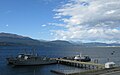
 Puerto Williams from the port.
 -
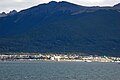 Puerto Williams from the Beagle Channel.
 -
 Puerto Williams in 1957.
 -
 Naval base of Puerto Williams.
 -
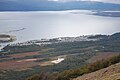 Puerto Williams from Cerro Bandera.


.jpg)

.jpg)
See also
- Bahía Wulaia
- Southernmost settlements
- Beagle conflict
- Alert, Nunavut, the northernmost continuously inhabited place in the world
References
External links
Template:Commons category-inline
- Information from the Chilean Tourism Service regarding activities in Puerto Williams and Cabo de Hornos National Park
- Spanish WP on Commune of Cabo de Hornos
- Puerto Williams and Commune of Cabo de Hornos official website
- Official website of Puerto Williams
- Prensa Antártica - News of the Antártica Chilena Province
- Museo Antropológico Martín Gusinde
- Cape Horn Biosphere Reserve
- Pages using infobox settlement with the wikidata parameter
- Pages with broken file links
- Capitals of Chilean provinces
- Cities and towns in Tierra del Fuego
- Navarino Island
- Populated places established in 1953
- Populated places in Antártica Chilena
- Ports and harbours of Chile
- Ports and harbours of the Atlantic Ocean
- Port settlements in Chile
- Populated places in the fjords and channels of Chile
- 1953 establishments in Chile