South Northamptonshire
Template:Short description Template:About Template:Use dmy dates Template:Main other{{#invoke:Infobox|infobox}}Template:Template other{{#invoke:Check for unknown parameters|check|unknown=Template:Main other|preview = Page using [[Template:Template:If empty]] with unknown parameter "_VALUE_"|ignoreblank=y|mapframe_args=y | alt | anthem | anthem_link | area_blank1_acre | area_blank1_dunam | area_blank1_ha | area_blank1_km2 | area_blank1_sq_mi | area_blank1_title | area_blank2_acre | area_blank2_dunam | area_blank2_ha | area_blank2_km2 | area_blank2_sq_mi | area_blank2_title | area_code | area_code_type | area_codes | area_footnotes | area_land_acre | area_land_dunam | area_land_ha | area_land_km2 | area_land_sq_mi | area_metro_acre | area_metro_dunam | area_metro_footnotes | area_metro_ha | area_metro_km2 | area_metro_sq_mi | area_note | area_rank | area_rural_acre | area_rural_dunam | area_rural_footnotes | area_rural_ha | area_rural_km2 | area_rural_sq_mi | area_total_acre | area_total_dunam | area_total_ha | area_total_km2 | area_total_sq_mi | area_urban_acre | area_urban_dunam | area_urban_footnotes | area_urban_ha | area_urban_km2 | area_urban_sq_mi | area_water_acre | area_water_dunam | area_water_ha | area_water_km2 | area_water_percent | area_water_sq_mi | blank_emblem_alt | blank_emblem_link | blank_emblem_size | blank_emblem_type | blank_emblem_sizedefault | blank_emblem_upright | blank_info | blank_info_sec1 | blank_info_sec2 | blank_name | blank_name_sec1 | blank_name_sec2 | blank1_info | blank1_info_sec1 | blank1_info_sec2 | blank1_name | blank1_name_sec1 | blank1_name_sec2 | blank2_info | blank2_info_sec1 | blank2_info_sec2 | blank2_name | blank2_name_sec1 | blank2_name_sec2 | blank3_info | blank3_info_sec1 | blank3_info_sec2 | blank3_name | blank3_name_sec1 | blank3_name_sec2 | blank4_info | blank4_info_sec1 | blank4_info_sec2 | blank4_name | blank4_name_sec1 | blank4_name_sec2 | blank5_info | blank5_info_sec1 | blank5_info_sec2 | blank5_name | blank5_name_sec1 | blank5_name_sec2 | blank6_info | blank6_info_sec1 | blank6_info_sec2 | blank6_name | blank6_name_sec1 | blank6_name_sec2 | blank7_info | blank7_info_sec1 | blank7_info_sec2 | blank7_name | blank7_name_sec1 | blank7_name_sec2 | caption | code1_info | code1_name | code2_info | code2_name | coor_pinpoint | coor_type | coordinates | coordinates_footnotes | demographics_type1 | demographics_type2 | demographics1_footnotes | demographics1_info1 | demographics1_info10 | demographics1_info2 | demographics1_info3 | demographics1_info4 | demographics1_info5 | demographics1_info6 | demographics1_info7 | demographics1_info8 | demographics1_info9 | demographics1_title1 | demographics1_title10 | demographics1_title2 | demographics1_title3 | demographics1_title4 | demographics1_title5 | demographics1_title6 | demographics1_title7 | demographics1_title8 | demographics1_title9 | demographics2_footnotes | demographics2_info1 | demographics2_info10 | demographics2_info2 | demographics2_info3 | demographics2_info4 | demographics2_info5 | demographics2_info6 | demographics2_info7 | demographics2_info8 | demographics2_info9 | demographics2_title1 | demographics2_title10 | demographics2_title2 | demographics2_title3 | demographics2_title4 | demographics2_title5 | demographics2_title6 | demographics2_title7 | demographics2_title8 | demographics2_title9 | dimensions_footnotes | dunam_link | elevation_footnotes | elevation_ft | elevation_link | elevation_m | elevation_max_footnotes | elevation_max_ft | elevation_max_m | elevation_max_point | elevation_max_rank | elevation_min_footnotes | elevation_min_ft | elevation_min_m | elevation_min_point | elevation_min_rank | elevation_point | embed | established_date | established_date1 | established_date2 | established_date3 | established_date4 | established_date5 | established_date6 | established_date7 | established_title | established_title1 | established_title2 | established_title3 | established_title4 | established_title5 | established_title6 | established_title7 | etymology | extinct_date | extinct_title | flag_alt | flag_border | flag_link | flag_size | footnotes | founder | geocode | governing_body | government_footnotes | government_type | government_blank1_title | government_blank1 | government_blank2_title | government_blank2 | government_blank2_title | government_blank3 | government_blank3_title | government_blank3 | government_blank4_title | government_blank4 | government_blank5_title | government_blank5 | government_blank6_title | government_blank6 | grid_name | grid_position | image_alt | image_blank_emblem | image_caption | image_flag | image_map | image_map1 | image_seal | image_shield | image_size | image_skyline | imagesize | image_sizedefault | image_upright | iso_code | leader_name | leader_name1 | leader_name2 | leader_name3 | leader_name4 | leader_name5 | leader_party | leader_title | leader_title1 | leader_title2 | leader_title3 | leader_title4 | leader_title5 | length_km | length_mi | map_alt | map_alt1 | map_caption | map_caption1 | mapsize | mapsize1 | module | motto | motto_link | mottoes | name | named_for | native_name | native_name_lang | nickname | nickname_link | nicknames | official_name | other_name | p1 | p10 | p11 | p12 | p13 | p14 | p15 | p16 | p17 | p18 | p19 | p2 | p20 | p21 | p22 | p23 | p24 | p25 | p26 | p27 | p28 | p29 | p3 | p30 | p31 | p32 | p33 | p34 | p35 | p36 | p37 | p38 | p39 | p4 | p40 | p41 | p42 | p43 | p44 | p45 | p46 | p47 | p48 | p49 | p5 | p50 | p6 | p7 | p8 | p9 | parts | parts_style | parts_type | pop_est_as_of | pop_est_footnotes | population | population_as_of | population_blank1 | population_blank1_footnotes | population_blank1_title | population_blank2 | population_blank2_footnotes | population_blank2_title | population_demonym | population_demonyms | population_density_blank1_km2 | population_density_blank1_sq_mi | population_density_blank2_km2 | population_density_blank2_sq_mi | population_density_km2 | population_density_metro_km2 | population_density_metro_sq_mi | population_density_rank | population_density_rural_km2 | population_density_rural_sq_mi | population_density_sq_mi | population_density_urban_km2 | population_density_urban_sq_mi | population_est | population_footnotes | population_metro | population_metro_footnotes | population_note | population_rank | population_rural | population_rural_footnotes | population_total | population_urban | population_urban_footnotes | postal_code | postal_code_type | postal2_code | postal2_code_type | pushpin_image | pushpin_label | pushpin_label_position | pushpin_map | pushpin_map_alt | pushpin_map_caption | pushpin_map_caption_notsmall | pushpin_map_narrow | pushpin_mapsize | pushpin_outside | pushpin_overlay | pushpin_relief | registration_plate | registration_plate_type | seal_alt | seal_link | seal_size | seal_type | seat | seat_type | seat1 | seat1_type | seat2 | seat2_type | settlement_type | shield_alt | shield_link | shield_size | short_description | subdivision_name | subdivision_name1 | subdivision_name2 | subdivision_name3 | subdivision_name4 | subdivision_name5 | subdivision_name6 | subdivision_type | subdivision_type1 | subdivision_type2 | subdivision_type3 | subdivision_type4 | subdivision_type5 | subdivision_type6 | template_name | timezone | timezone_DST | timezone_link | timezone1 | timezone1_DST | timezone1_location | timezone2 | timezone2_DST | timezone2_location | timezone3 | timezone3_DST | timezone3_location | timezone4 | timezone4_DST | timezone4_location | timezone5 | timezone5_DST | timezone5_location | total_type | translit_lang1 | translit_lang1_info | translit_lang1_info1 | translit_lang1_info2 | translit_lang1_info3 | translit_lang1_info4 | translit_lang1_info5 | translit_lang1_info6 | translit_lang1_type | translit_lang1_type1 | translit_lang1_type2 | translit_lang1_type3 | translit_lang1_type4 | translit_lang1_type5 | translit_lang1_type6 | translit_lang2 | translit_lang2_info | translit_lang2_info1 | translit_lang2_info2 | translit_lang2_info3 | translit_lang2_info4 | translit_lang2_info5 | translit_lang2_info6 | translit_lang2_type | translit_lang2_type1 | translit_lang2_type2 | translit_lang2_type3 | translit_lang2_type4 | translit_lang2_type5 | translit_lang2_type6 | type | unit_pref | utc_offset | utc_offset_DST | utc_offset1 | utc_offset1_DST | utc_offset2 | utc_offset2_DST | utc_offset3 | utc_offset3_DST | utc_offset4 | utc_offset4_DST | utc_offset5 | utc_offset5_DST | website | width_km | width_mi }}{{#invoke:Check for clobbered parameters|check | template = [[Template:Template:If empty]] | cat = Template:Main other | population; population_total | image_size; imagesize | image_alt; alt | image_caption; caption | settlement_type; type | utc_offset1; utc_offset | timezone1; timezone }}{{#if:
|
}}Template:Main other{{#ifexpr:{{#invoke:ParameterCount|main|mapframe|image_map|image_map1|pushpin_map}} >2 |Template:Main other}}
South Northamptonshire was a local government district in Northamptonshire, England, from 1974 to 2021. Its council was based in the town of Towcester, first established as a settlement in Roman Britain. The population of the Local Authority District Council in 2011 was 85,189.<ref>{{#invoke:citation/CS1|citation |CitationClass=web }}</ref>
The largest town in the district was Brackley, which had a population of 14,000 in 2008,<ref name = "SNC"/> followed by Towcester, which had a population of nearly 10,000.<ref name = "SNC"/> Other significant settlements in size included Deanshanger, Bugbrooke, Roade, King's Sutton, Silverstone and Middleton Cheney. Many of the villages listed had populations exceeding 1,000.<ref group="n">Such as Kislingbury, Potterspury and Yardley Gobion</ref>
Geography
Elevations and shape
The northern half of the district was generally higher than the south, reaching 192m AOD<ref name="os">pOrdnance Survey map for grid reference SP44</ref> northeast of the centre of Aston-le-Walls, and 182m on the road east of Culworth, a village which also rests on top of the ridge following the general WSW line of the county and of the district but except for this is north of the district. This ridge is part of the Jurassic Way.<ref group="n">On the third main ridge of Oolitic limestone in Britain (other than the Cotswolds and the North York Moors)</ref> Lower parts are at 85m AOD (above mean sea level) in the southwest corner<ref group="n">The border here in the southwest is the River Cherwell</ref> and Template:Convert AOD in the northeast.<ref group="n">The border here in the northeast is the River Nene after it has flowed through Northampton</ref>
The district was shaped approximately like the Christian cross in an ENE orientation extending from its top at the southeast of Northampton and reaching to a north–south line south-by-southeast of Banbury, Oxfordshire. An additional arm near its foot reached north through the large village of Chipping Warden to Upper Boddington.
Soil and geology
Land was taken up with for the most part with arable agriculture peppered by villages, however allows space for two towns of significant size. Supporting this <ref>National Soil Resources Institute - Cranfield University</ref> is a regular interspersion of two high fertility types of soil for most plants and crops: freely draining slightly acid but base-rich; and lime-rich loamy and clayey soils with impeded drainage soils, on a default (generally slightly lower) soil of slowly permeable seasonally wet slightly acid but base-rich loamy and clayey soils (of medium fertility). The district in terms of watercourses had sources and headwaters of the rivers Cherwell, Great Ouse and Nene.<ref name=os/>
Whittlewood Forest
Whittlewood Forest occupies a modest area for a forest and is broken up by fields (in the southern arm close to Milton Keynes which reaches to the Great Ouse) and this surrounds Whittlebury, the fields south of the upland village of Paulerspury on straight, Roman Watling Street which passes through the forest. This lies between Silverstone and Potterspury (also with a conservation area on Watling Street) or equally between Deanshanger and Towcester.
Demography and human geography
With just over 79,293 people in 2000<ref>{{#invoke:citation/CS1|citation |CitationClass=web }}</ref> and 91,000 in 2008, a 14.8% increase.<ref name = "SNC">Template:Cite book</ref>
The growth in population between 2001 and 2007 was the third largest of all districts in the country and consisted of 35,700 households.<ref name = "TWA">Template:Cite book</ref>
The district was notable for the proportion of and growth in detached houses, and the district was one of a tiny proportion to have seen a growth in the proportion of this type of home relative to other types between 2001 and 2011.<ref>2011 Census interactive census map</ref>
History

The district was formed on 1 April 1974, under the Local Government Act 1972, and was a merger of the municipal borough of Brackley, along with Brackley Rural District, Towcester Rural District, and part of Northampton Rural District.
The council chose to based itself in Towcester. It was initially based itself at Towcester Town Hall, which had been built in 1865 and had been bought by Towcester Rural District Council in 1935.<ref>Template:NHLE</ref><ref>Template:Cite news</ref><ref>Template:London Gazette</ref> The council moved to a new building at the junction of Springfields and Brackley Road in 1982, which in turn was replaced by another new building called The Forum on Moat Lane in 2015.<ref>{{#invoke:citation/CS1|citation |CitationClass=web }}</ref>
Abolition and replacement
In March 2018 at Northamptonshire County Council, following financial and cultural mismanagement by the cabinet and officers, the then Secretary of State for Local Government, Sajid Javid, sent commissioner Max Caller into the council, who recommended the county council and all district and borough councils in the county be abolished, and replaced by two unitary authorities, one covering the West, and one the North of the county.<ref>{{#invoke:citation/CS1|citation |CitationClass=web }}</ref> These proposals were approved in April 2019. It meant that the districts of Daventry, Northampton and South Northamptonshire were merged to form a new unitary authority called West Northamptonshire, whilst the second unitary authority North Northamptonshire consists of Corby, East Northamptonshire, Kettering and Wellingborough districts. These new authorities came into being on 1 April 2021.<ref>{{#invoke:citation/CS1|citation |CitationClass=web }}</ref> Elections for the new authorities were due to be held on 7 May 2020, but were delayed due to the COVID-19 pandemic.<ref>{{#invoke:citation/CS1|citation |CitationClass=web }}</ref>
Settlements and parishes
For a county-wide list for Northamptonshire see List of places in Northamptonshire
- Abthorpe, Adstone, Ashton, Aston le Walls, Astrop, Aynho
- Blakesley, Blisworth, Boddington, Brackley, Bradden, Brafield-on-the-Green, Bugbrooke
- Caldecote, Castle Ashby, Chacombe, Charlton, Chipping Warden, Cogenhoe, Cold Higham, Cosgrove, Courteenhall, Croughton, Culworth
- Deanshanger, Denton
- Easton Neston, Edgcote, Evenley, Eydon
- Farthinghoe
- Gayton, Grafton Regis, Grange Park, Greatworth, Greens Norton, Grimscote
- Hackleton, Harpole, Hartwell, Helmdon, Hinton-in-the-Hedges
- King's Sutton, Kislingbury
- Litchborough, Little Houghton
- Maidford, Marston St Lawrence, Middleton Cheney, Milton Malsor, Moreton Pinkney
- Nether Heyford, Newbottle
- Old Stratford, Overthorpe
- Pattishall, Paulerspury, Potterspury
- Quinton
- Radstone, Roade, Rothersthorpe
- Shutlanger, Silverstone, Slapton, Stoke Bruerne, Sulgrave, Syresham
- Thenford, Thorpe Mandeville, Tiffield, Towcester
- Upper Heyford
- Wappenham, Warkworth, Weedon Lois, Weston, Whiston, Whitfield, Whittlebury, Wicken, Woodend
- Yardley Gobion, Yardley Hastings
Gallery
-
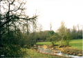 Farmland outside the village of King's Sutton in Northamptonshire in 2009.
 -
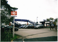 King's Sutton railway station was upgraded and re-gained its footbridge in 2009.
 -
 A picture of King' Sutton in 2000.
 -
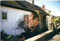
 A picture of King's Sutton in 2000.
.png)
.png)

.png)
Museum
Arms
See also
- South Northamptonshire local elections
- Grade I listed buildings in South Northamptonshire
- Grade II* listed buildings in South Northamptonshire
Notes and references
- Notes
- References