Nógrád County
Template:Short description Template:About Template:Main other{{#invoke:Infobox|infobox}}Template:Template other{{#invoke:Check for unknown parameters|check|unknown=Template:Main other|preview = Page using [[Template:Template:If empty]] with unknown parameter "_VALUE_"|ignoreblank=y|mapframe_args=y | alt | anthem | anthem_link | area_blank1_acre | area_blank1_dunam | area_blank1_ha | area_blank1_km2 | area_blank1_sq_mi | area_blank1_title | area_blank2_acre | area_blank2_dunam | area_blank2_ha | area_blank2_km2 | area_blank2_sq_mi | area_blank2_title | area_code | area_code_type | area_codes | area_footnotes | area_land_acre | area_land_dunam | area_land_ha | area_land_km2 | area_land_sq_mi | area_metro_acre | area_metro_dunam | area_metro_footnotes | area_metro_ha | area_metro_km2 | area_metro_sq_mi | area_note | area_rank | area_rural_acre | area_rural_dunam | area_rural_footnotes | area_rural_ha | area_rural_km2 | area_rural_sq_mi | area_total_acre | area_total_dunam | area_total_ha | area_total_km2 | area_total_sq_mi | area_urban_acre | area_urban_dunam | area_urban_footnotes | area_urban_ha | area_urban_km2 | area_urban_sq_mi | area_water_acre | area_water_dunam | area_water_ha | area_water_km2 | area_water_percent | area_water_sq_mi | blank_emblem_alt | blank_emblem_link | blank_emblem_size | blank_emblem_type | blank_emblem_sizedefault | blank_emblem_upright | blank_info | blank_info_sec1 | blank_info_sec2 | blank_name | blank_name_sec1 | blank_name_sec2 | blank1_info | blank1_info_sec1 | blank1_info_sec2 | blank1_name | blank1_name_sec1 | blank1_name_sec2 | blank2_info | blank2_info_sec1 | blank2_info_sec2 | blank2_name | blank2_name_sec1 | blank2_name_sec2 | blank3_info | blank3_info_sec1 | blank3_info_sec2 | blank3_name | blank3_name_sec1 | blank3_name_sec2 | blank4_info | blank4_info_sec1 | blank4_info_sec2 | blank4_name | blank4_name_sec1 | blank4_name_sec2 | blank5_info | blank5_info_sec1 | blank5_info_sec2 | blank5_name | blank5_name_sec1 | blank5_name_sec2 | blank6_info | blank6_info_sec1 | blank6_info_sec2 | blank6_name | blank6_name_sec1 | blank6_name_sec2 | blank7_info | blank7_info_sec1 | blank7_info_sec2 | blank7_name | blank7_name_sec1 | blank7_name_sec2 | caption | code1_info | code1_name | code2_info | code2_name | coor_pinpoint | coor_type | coordinates | coordinates_footnotes | demographics_type1 | demographics_type2 | demographics1_footnotes | demographics1_info1 | demographics1_info10 | demographics1_info2 | demographics1_info3 | demographics1_info4 | demographics1_info5 | demographics1_info6 | demographics1_info7 | demographics1_info8 | demographics1_info9 | demographics1_title1 | demographics1_title10 | demographics1_title2 | demographics1_title3 | demographics1_title4 | demographics1_title5 | demographics1_title6 | demographics1_title7 | demographics1_title8 | demographics1_title9 | demographics2_footnotes | demographics2_info1 | demographics2_info10 | demographics2_info2 | demographics2_info3 | demographics2_info4 | demographics2_info5 | demographics2_info6 | demographics2_info7 | demographics2_info8 | demographics2_info9 | demographics2_title1 | demographics2_title10 | demographics2_title2 | demographics2_title3 | demographics2_title4 | demographics2_title5 | demographics2_title6 | demographics2_title7 | demographics2_title8 | demographics2_title9 | dimensions_footnotes | dunam_link | elevation_footnotes | elevation_ft | elevation_link | elevation_m | elevation_max_footnotes | elevation_max_ft | elevation_max_m | elevation_max_point | elevation_max_rank | elevation_min_footnotes | elevation_min_ft | elevation_min_m | elevation_min_point | elevation_min_rank | elevation_point | embed | established_date | established_date1 | established_date2 | established_date3 | established_date4 | established_date5 | established_date6 | established_date7 | established_title | established_title1 | established_title2 | established_title3 | established_title4 | established_title5 | established_title6 | established_title7 | etymology | extinct_date | extinct_title | flag_alt | flag_border | flag_link | flag_size | footnotes | founder | geocode | governing_body | government_footnotes | government_type | government_blank1_title | government_blank1 | government_blank2_title | government_blank2 | government_blank2_title | government_blank3 | government_blank3_title | government_blank3 | government_blank4_title | government_blank4 | government_blank5_title | government_blank5 | government_blank6_title | government_blank6 | grid_name | grid_position | image_alt | image_blank_emblem | image_caption | image_flag | image_map | image_map1 | image_seal | image_shield | image_size | image_skyline | imagesize | image_sizedefault | image_upright | iso_code | leader_name | leader_name1 | leader_name2 | leader_name3 | leader_name4 | leader_name5 | leader_party | leader_title | leader_title1 | leader_title2 | leader_title3 | leader_title4 | leader_title5 | length_km | length_mi | map_alt | map_alt1 | map_caption | map_caption1 | mapsize | mapsize1 | module | motto | motto_link | mottoes | name | named_for | native_name | native_name_lang | nickname | nickname_link | nicknames | official_name | other_name | p1 | p10 | p11 | p12 | p13 | p14 | p15 | p16 | p17 | p18 | p19 | p2 | p20 | p21 | p22 | p23 | p24 | p25 | p26 | p27 | p28 | p29 | p3 | p30 | p31 | p32 | p33 | p34 | p35 | p36 | p37 | p38 | p39 | p4 | p40 | p41 | p42 | p43 | p44 | p45 | p46 | p47 | p48 | p49 | p5 | p50 | p6 | p7 | p8 | p9 | parts | parts_style | parts_type | pop_est_as_of | pop_est_footnotes | population | population_as_of | population_blank1 | population_blank1_footnotes | population_blank1_title | population_blank2 | population_blank2_footnotes | population_blank2_title | population_demonym | population_demonyms | population_density_blank1_km2 | population_density_blank1_sq_mi | population_density_blank2_km2 | population_density_blank2_sq_mi | population_density_km2 | population_density_metro_km2 | population_density_metro_sq_mi | population_density_rank | population_density_rural_km2 | population_density_rural_sq_mi | population_density_sq_mi | population_density_urban_km2 | population_density_urban_sq_mi | population_est | population_footnotes | population_metro | population_metro_footnotes | population_note | population_rank | population_rural | population_rural_footnotes | population_total | population_urban | population_urban_footnotes | postal_code | postal_code_type | postal2_code | postal2_code_type | pushpin_image | pushpin_label | pushpin_label_position | pushpin_map | pushpin_map_alt | pushpin_map_caption | pushpin_map_caption_notsmall | pushpin_map_narrow | pushpin_mapsize | pushpin_outside | pushpin_overlay | pushpin_relief | registration_plate | registration_plate_type | seal_alt | seal_link | seal_size | seal_type | seat | seat_type | seat1 | seat1_type | seat2 | seat2_type | settlement_type | shield_alt | shield_link | shield_size | short_description | subdivision_name | subdivision_name1 | subdivision_name2 | subdivision_name3 | subdivision_name4 | subdivision_name5 | subdivision_name6 | subdivision_type | subdivision_type1 | subdivision_type2 | subdivision_type3 | subdivision_type4 | subdivision_type5 | subdivision_type6 | template_name | timezone | timezone_DST | timezone_link | timezone1 | timezone1_DST | timezone1_location | timezone2 | timezone2_DST | timezone2_location | timezone3 | timezone3_DST | timezone3_location | timezone4 | timezone4_DST | timezone4_location | timezone5 | timezone5_DST | timezone5_location | total_type | translit_lang1 | translit_lang1_info | translit_lang1_info1 | translit_lang1_info2 | translit_lang1_info3 | translit_lang1_info4 | translit_lang1_info5 | translit_lang1_info6 | translit_lang1_type | translit_lang1_type1 | translit_lang1_type2 | translit_lang1_type3 | translit_lang1_type4 | translit_lang1_type5 | translit_lang1_type6 | translit_lang2 | translit_lang2_info | translit_lang2_info1 | translit_lang2_info2 | translit_lang2_info3 | translit_lang2_info4 | translit_lang2_info5 | translit_lang2_info6 | translit_lang2_type | translit_lang2_type1 | translit_lang2_type2 | translit_lang2_type3 | translit_lang2_type4 | translit_lang2_type5 | translit_lang2_type6 | type | unit_pref | utc_offset | utc_offset_DST | utc_offset1 | utc_offset1_DST | utc_offset2 | utc_offset2_DST | utc_offset3 | utc_offset3_DST | utc_offset4 | utc_offset4_DST | utc_offset5 | utc_offset5_DST | website | width_km | width_mi }}{{#invoke:Check for clobbered parameters|check | template = [[Template:Template:If empty]] | cat = Template:Main other | population; population_total | image_size; imagesize | image_alt; alt | image_caption; caption | settlement_type; type | utc_offset1; utc_offset | timezone1; timezone }}{{#if:
|
}}Template:Main other{{#ifexpr:{{#invoke:ParameterCount|main|mapframe|image_map|image_map1|pushpin_map}} >2 |Template:Main other}} Nógrád (Template:Langx, {{#invoke:IPA|main}}; Template:Langx) is a county (Template:Langx) of Hungary. It sits on the northern edge of Hungary and borders Slovakia.
Description
Nógrád county lies in northern Hungary. It shares borders with Slovakia and the Hungarian counties Pest, Heves and Borsod-Abaúj-Zemplén. The capital of Nógrád county is Salgótarján. Its area is 2,544 km². It is the smallest county by population and the second smallest by area (after Komárom-Esztergom).
Nógrád is famous for its historic architecture of ancient Gothic churches and stone castles dated to the 13th century. Some historic landmarks includes the Salgó Castle and several baroque buildings constructed in the 18th century and the Vay, Teleki. Much of the northern border of the county is formed by the river Ipoly. The mountain ranges Börzsöny, Cserhát and Mátra lie partly in the county.
Due to the mountains, the county is characterised by small villages nestled in the valleys. The two largest settlements are Balassagyarmat, the former county seat, and Salgótarján, which has become a center of industry in the early 20th century due to coal mines nearby.
History
{{#invoke:Labelled list hatnote|labelledList|Main article|Main articles|Main page|Main pages}} Nógrád (Template:Langx, Template:Langx or {{#invoke:Lang|lang}}, Template:Langx) was also the name of a historic administrative county (comitatus) of the Kingdom of Hungary. The name stems from the former Nógrád castle (Template:Langx - this name is still used in Slovakia as well as the informal designation of the corresponding territory, now located in southern Slovakia and in northern Hungary). In turn, Novohrad means "new castle" in Slovak.
Demographics
The population of Nógrád County was 182,459 as of the 2022 Census, with a population density of 72 individuals per square kilometer (72/km2). The number of households was 75,526 and the number of families was 49,077. Since the 2011 Census, the population decreased by 19,968 (-9.9%).<ref name="ksh-2022-db"></ref>
Template:Historical populations
Ethnicity
In the 2022 Census, the vast majority (86.3%) of the population identified as Hungarian. A minority of 7.8% identified as belonging to another ethnic group and 11.3% of the population did not respond. The ethnic groups most identified with were Romani (5.8%), Slovakian (1.2%), and German (0.4%). Small numbers identified as other domestic ethnic groups (390) or other groups (421).<ref name="ksh-2022-db"></ref>Template:Efn
In the 2011 Census, 85.4% of the population identified as Hungarian. Nearly a tenth (9.6%) of the population identified as belonging to another ethnic group and 13.0% did not respond. Romani made up 7.5% of the population, Slovakian 1.3%, and German (0.5%). Small numbers identified as other domestic ethnic groups (407) or other groups (308).<ref name=2011-nograd></ref>Template:Efn
Religion
Template:See alsoTemplate:Pie chart
In the 2022 Census, just over half of the population (51.4%) were religious adherents. The largest religious community was Roman Catholic (42.5%). Other communities included Lutheran (3.4%), Calvinist (2.0%), Greek Catholic (0.3%), Other Christian denomination (2.1%), and other religious affiliations (0.2%). Small numbers (less than 100) were affiliated with Judaism and Orthodox Christianity. The non-religious made up 12.2% of the population. More than a third (36.4%) of the population did not respond.
In the 2011 Census, 63.4% of the population were religious adherents. The largest religious community was Roman Catholic (55.4%). Others included Lutheran (3.9%), Calvinist (2.1%), Greek Catholic (0.2%), Other Christian denomination (1.6%), and other religious affiliations (0.2%). Small numbers (less than 100) were affiliated with Judaism and Orthodox Christianity. Atheists made up (0.9%) of the population and other non-religious made up 12.2%. Nearly a quarter (23.5%) of the population did not respond.<ref name="ksh-2022-db"></ref>
In 1930, the population was 85.6% Roman Catholic, 9.4% Lutheran, 2.8% Jewish, 1.9% Calvinist, and others (0.3%).<ref name="2011-nograd"></ref>
Regional structure

| № | English and Hungarian names |
Area (km²) |
Population (2022) |
Density (pop./km²) |
Seat | № of municipalities |
| 1 | Balassagyarmat District Balassagyarmati járás |
532.94 | 36,606 | 69 | Balassagyarmat | 29 |
| 2 | Bátonyterenye District Bátonyterenyei járás |
215.45 | 18,878 | 88 | Bátonyterenye | 8 |
| 3 | Pásztó District Pásztói járás |
551.56 | 29,415 | 53 | Pásztó | 26 |
| 4 | Rétság District Rétsági járás |
435.03 | 24,222 | 56 | Rétság | 25 |
| 5 | Salgótarján District Salgótarjáni járás |
525.23 | 55,769 | 106 | Salgótarján | 29 |
| 6 | Szécsény District Szécsényi járás |
285.26 | 17,569 | 62 | Szécsény | 14 |
| Nógrád County | 2,545.48 | 182,459 | 72 | Salgótarján | 131 | |
|---|---|---|---|---|---|---|
Politics
{{#invoke:Labelled list hatnote|labelledList|Main article|Main articles|Main page|Main pages}} The Nógrád County Council, elected at the 2024 local government elections,<ref>{{#invoke:citation/CS1|citation |CitationClass=web }}</ref> is made up of 15 counselors,<ref>{{#invoke:citation/CS1|citation |CitationClass=web }}</ref> with the following party composition:
| Party | Seats | Current County Assembly | ||||||||||
|---|---|---|---|---|---|---|---|---|---|---|---|---|
| style="background-color: Template:Party color | | Fidesz-KDNP | 10 | style="background-color: Template:Party color | | style="background-color: Template:Party color | | style="background-color: Template:Party color | | style="background-color: Template:Party color | | style="background-color: Template:Party color | | style="background-color: Template:Party color | | style="background-color: Template:Party color | | style="background-color: Template:Party color | | style="background-color: Template:Party color | | style="background-color: Template:Party color | |
| Our Homeland Movement | 3 | |||||||||||
| style="background-color: Template:Party color | | Democratic Coalition | 1 | style="background-color: Template:Party color | | |||||||||
| Momentum Movement | 1 | |||||||||||
Presidents of the General Assembly
| List of presidents since 1990<ref>Önkormányzati választások eredményei Template:In lang</ref><ref>General Assembly website</ref> | |
|---|---|
| Ferenc Korill (SZDSZ) | 1990–1994 |
| Sándor Smitnya (SZDSZ) | 1994–1998 |
| Zsolt Becsó (Fidesz) | 1998–2002 |
| Ottó Dóra (MSZP) | 2002–2006 |
| Zsolt Becsó (Fidesz-KDNP) | 2006–2014 |
| Nándor Skuczi (Fides-KDNP) | 2014– |
Municipalities
Nógrád County has 1 urban county, 5 towns and 125 villages.
- City with county rights
(ordered by population, as of 2011 census)
 Salgótarján (37,262) – county seat
- Towns
 Balassagyarmat (16,397)
- File:HUN Bátonyterenye Címer.svg Bátonyterenye (12,841)
- File:HUN Pásztó Címer.svg Pásztó (9,689)
- File:HUN Szécsény Címer.svg Szécsény (5,962)
- File:Coa Hungary Town Rétság.svg Rétság (2,822)
- Villages
- Alsópetény
- Alsótold
- Bánk
- Bárna
- Becske
- Bercel
- Berkenye
- Bér
- Bokor
- Borsosberény
- Buják
- Cered
- Csécse
- Cserháthaláp
- Cserhátsurány
- Cserhátszentiván
- Csesztve
- Csitár
- Debercsény
- Dejtár
- Diósjenő
- Dorogháza
- Drégelypalánk
- Ecseg
- Egyházasdengeleg
- Egyházasgerge
- Endrefalva
- Erdőkürt
- Erdőtarcsa
- Érsekvadkert
- Etes
- Felsőpetény
- Felsőtold
- Galgaguta
- Garáb
- Herencsény
- Héhalom
- Hollókő
- Hont
- Horpács
- Hugyag
- Iliny
- Ipolyszög
- Ipolytarnóc
- Ipolyvece
- Jobbágyi
- Karancsalja
- Karancsberény
- Karancskeszi
- Karancslapujtő
- Karancsság
- Kazár
- Kálló
- Keszeg
- Kétbodony
- Kisbágyon
- Kisbárkány
- Kisecset
- Kishartyán
- Kozárd
- Kutasó
- Legénd
- Litke
- Lucfalva
- Ludányhalászi
- Magyargéc
- Magyarnándor
- Márkháza
- Mátramindszent
- Mátranovák
- Mátraszele
- Mátraszőlős
- Mátraterenye
- Mátraverebély
- Mihálygerge
- Mohora
- Nagybárkány
- Nagykeresztúr
- Nagylóc
- Nagyoroszi
- Nemti
- Nézsa
- Nógrád
- Nógrádkövesd
- Nógrádmarcal
- Nógrádmegyer
- Nógrádsáp
- Nógrádsipek
- Nógrádszakál
- Nőtincs
- Őrhalom
- Ősagárd
- Palotás
- Patak
- Patvarc
- Piliny
- Pusztaberki
- Rákóczibánya
- Rimóc
- Romhány
- Ságújfalu
- Sámsonháza
- Somoskőújfalu
- Sóshartyán
- Szalmatercs
- Szanda
- Szarvasgede
- Szátok
- Szendehely
- Szente
- Szécsénke
- Szécsényfelfalu
- Szilaspogony
- Szirák
- Szuha
- Szurdokpüspöki
- Szügy
- Tar
- Terény
- Tereske
- Tolmács
- Vanyarc
- Varsány
- Vizslás
- Zabar
Gallery
-
 Salgótarján, the capital of the county
 -
 Hollókő village
 -

-
 Forgách Mansion in Szécsény
 -
 The Cserhát mountain range
 -
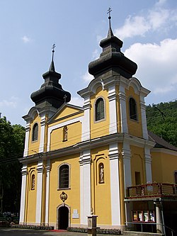 Our Lady church in Mátraverebély
 -

-
 Teleki Mansion in Szirák

.jpg)

.jpg)

_(6722._sz%C3%A1m%C3%BA_m%C5%B1eml%C3%A9k)_3.jpg)
.jpg)

Notes
References
Template:Sister project Template:Wikivoyage Template:Reflist
External links
- Official site in Hungarian
- Nógrád Megyei Hírlap (nhc24.hu) - The county portal
- Photos from Nograd County
Template:Nógrád Template:Districts of Nógrád County Template:Hungarian counties Template:Regions of Hungary